| Pages:
1
..
3
4
5
6 |
TMW
Select Nomad

Posts: 10659
Registered: 9-1-2003
Location: Bakersfield, CA
Member Is Offline
|
|
I just logged way points.
|
|
|
ehall
Super Nomad
Posts: 1906
Registered: 3-29-2014
Location: Buckeye, Az
Member Is Offline
Mood: It's 5 o'clock somewhere
|
|
Now I want to go and try to climb the rock!
|
|
|
ChuckMRN
Newbie
Posts: 10
Registered: 3-15-2015
Member Is Offline
|
|
Your rig would prob make it look easy Ed!
|
|
|
ehall
Super Nomad
Posts: 1906
Registered: 3-29-2014
Location: Buckeye, Az
Member Is Offline
Mood: It's 5 o'clock somewhere
|
|
Hey chuck how ya been? If these guys get a trip going this winter hope you can make it.
|
|
|
Ken Cooke
Elite Nomad
Posts: 8921
Registered: 2-9-2004
Location: Riverside, CA
Member Is Offline
Mood: Black Trans Lives Matter
|
|
Questions for TW
On my Pole Line Trip in November 2013, our group traveled up the Summit #2 and stumbled upon a tricky stairstep section that required each Jeep walk
up each step using front and rear lockers.
Question: Does Summit #3 have tricky sections like this one that I describe? With my short-wheelbase, lifted Jeep, hill climbs are less than stable
experiences I'd rather avoid.
Question: Have you come across this super steep climb on Summit #2 and what was your impression of it??
|
|
|
TMW
Select Nomad
Posts: 10659
Registered: 9-1-2003
Location: Bakersfield, CA
Member Is Offline
|
|
I have not been on Summit #3, at least yet.
The last time I was on Summit #2 was about 11 years ago and I don't recall how steep it was. I went up it in my 93 Toyota with no front locker. I
don't remember having any problems but as you know the rains can change everything.
A couple of years ago SCORE had to re-route the SF250 race because the rains had messed up the course up the race Summit #1.
|
|
|
David K
Honored Nomad
Posts: 64514
Registered: 8-30-2002
Location: San Diego County
Member Is Offline
Mood: Have Baja Fever
|
|
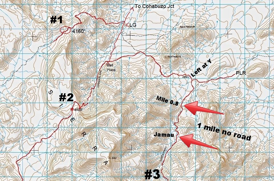
Ken, the purpose of the guy's last trip there was to see if the Mexican topo map was true, and a road came down from Summit 3 to the Pole Line Road
(at the Y/ Cañon Jamau Ranch), as it shows.
The finding is no... Lower end road ends near the canyon entrance, 0.8 mile from the Y. It is approx. 1 mile from there to the ranch/ shack site
'Jamau'. Photos they took look like no road ever existed in that mile.
From the ranch/ shack location (Gulick photos) up to the summit (#3) a road IS seen on Google Earth.
|
|
|
TMW
Select Nomad
Posts: 10659
Registered: 9-1-2003
Location: Bakersfield, CA
Member Is Offline
|
|
I'm planning another walk this Oct when it is cooler. From the end of the road coming from the PLR Y we got maybe half way to what looked to be a
water falls as we had to climb almost straight up 20+ feet or more. We walked back following a cow trail that was pretty easy more or less.
I plan to take the cow trail to the water falls then continue on to the shack if there is one and at least verify a road coming down from Summit #3.
I'm hoping the walk from the water fall toward the shack is not as bad as it was the first time in the wash.
Boulders, trees and bushes are not always fun.
|
|
|
PaulW
Ultra Nomad
Posts: 3014
Registered: 5-21-2013
Member Is Offline
|
|
Count me in . Late Oct
=======
Quote: Originally posted by TMW  | I'm planning another walk this Oct when it is cooler. From the end of the road coming from the PLR Y we got maybe half way to what looked to be a
water falls as we had to climb almost straight up 20+ feet or more. We walked back following a cow trail that was pretty easy more or less.
I plan to take the cow trail to the water falls then continue on to the shack if there is one and at least verify a road coming down from Summit #3.
I'm hoping the walk from the water fall toward the shack is not as bad as it was the first time in the wash.
Boulders, trees and bushes are not always fun. |
|
|
|
TMW
Select Nomad
Posts: 10659
Registered: 9-1-2003
Location: Bakersfield, CA
Member Is Offline
|
|
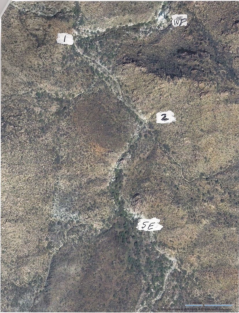
Here are two images of the path. The first is a Google Earth image of where the road ends at both the north end and south end.
From GE

Bing image shows a more clear picture. WF is the site of the water falls. SE is the south end and you can see the road coming in from Summit #3.
|
|
|
TMW
Select Nomad
Posts: 10659
Registered: 9-1-2003
Location: Bakersfield, CA
Member Is Offline
|
|
Thanks Paul, your in.
|
|
|
Ken Cooke
Elite Nomad
Posts: 8921
Registered: 2-9-2004
Location: Riverside, CA
Member Is Offline
Mood: Black Trans Lives Matter
|
|
TW - When we drove up (either Summit #1 or #2), we came across a seriously steep section of trail with stairsteps out of a Godzilla movie. I didn't
turn around or back off of the gas - just locked both axles and drove up it. Craziest mountain trail I've ever driven.
|
|
|
TMW
Select Nomad
Posts: 10659
Registered: 9-1-2003
Location: Bakersfield, CA
Member Is Offline
|
|
That had to be #2 because #1 was not a problem except where I met the rock. The bypass route around it was OK.
|
|
|
ehall
Super Nomad
Posts: 1906
Registered: 3-29-2014
Location: Buckeye, Az
Member Is Offline
Mood: It's 5 o'clock somewhere
|
|
Is one of those trails El Mano Pass?
|
|
|
Ken Cooke
Elite Nomad
Posts: 8921
Registered: 2-9-2004
Location: Riverside, CA
Member Is Offline
Mood: Black Trans Lives Matter
|
|
Look at this link from my Facebook page: https://www.facebook.com/BajaPoleLineGroup
album: Camp: Lower Mano Canyon
link: https://www.facebook.com/media/set/?set=a.619342491455971.10...
album: Jeep: Mano Canyon, Sierra Juarez, Ensenada, Tijuana
link: https://www.facebook.com/media/set/?set=a.619347511455469.10...
The steep hillclimb with the two built Jeeps shows a milder portion of the trail. Crazy camber with 1,000 ft. dropoff (w/washouts), rocky, and STEEP
climbs.
|
|
|
David K
Honored Nomad
Posts: 64514
Registered: 8-30-2002
Location: San Diego County
Member Is Offline
Mood: Have Baja Fever
|
|
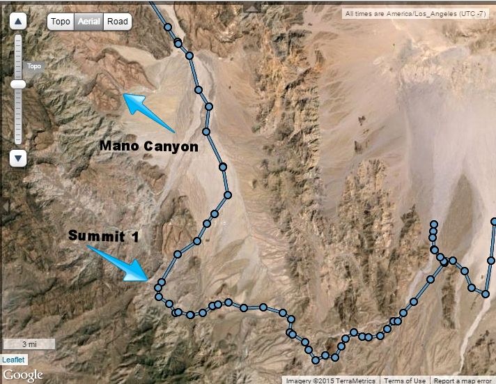
Nope...
The Mano Canyon road joined the one we were on last April, just south of Cohabuzo Jcn. (where we met up with Mick and the Bronco). Where the first
fence gate we opened and went left in the wash (following John M's GPS), the Mano Canyon junction was on the right road.
Here is your Pole Line Trip track map with the two mountain routes pointed out:
|
|
|
ehall
Super Nomad
Posts: 1906
Registered: 3-29-2014
Location: Buckeye, Az
Member Is Offline
Mood: It's 5 o'clock somewhere
|
|
Thanks
|
|
|
David K
Honored Nomad
Posts: 64514
Registered: 8-30-2002
Location: San Diego County
Member Is Offline
Mood: Have Baja Fever
|
|
My pleasure Ed.
|
|
|
Ken Cooke
Elite Nomad
Posts: 8921
Registered: 2-9-2004
Location: Riverside, CA
Member Is Offline
Mood: Black Trans Lives Matter
|
|
This map makes clear sense of the route I took in Nov. 2013 
|
|
|
David K
Honored Nomad
Posts: 64514
Registered: 8-30-2002
Location: San Diego County
Member Is Offline
Mood: Have Baja Fever
|
|
Thanks Ken. It shows the nearly equal distance to Guadalupe Canyon from either Hwy. 3 or Hwy. 5. That fork 2.4 miles south of Cohabuzo Jcn. is the
road south to the Pole Line Road (apparently too rough for the Auto Club mappers who turned around at 3.1 miles).
|
|
|
| Pages:
1
..
3
4
5
6 |


