| Pages:
1
2 |
Aldervale
Junior Nomad

Posts: 95
Registered: 12-22-2013
Member Is Offline
|
|
El Marmol Gieser ?
Does anyone know about a geiser in the drainage below and east of the El Marmol site ?
We visited several years ago and there was evidence of thermal and mineral action but never saw any real activity.
Perhaps it is more active in a particular season?
Has anyone explored further past the geiser site toward the gulf ?
We hope to hike further down in January
Many thanks
Aldervale
|
|
|
David K
Honored Nomad
Posts: 65587
Registered: 8-30-2002
Location: San Diego County
Member Is Offline
Mood: Have Baja Fever
|
|
Quote: Originally posted by Aldervale  | Does anyone know about a geiser in the drainage below and east of the El Marmol site ?
We visited several years ago and there was evidence of thermal and mineral action but never saw any real activity.
Perhaps it is more active in a particular season?
Has anyone explored further past the geiser site toward the gulf ?
We hope to hike further down in January
Many thanks
Aldervale |
YES!! Both the geyser and miles down the arroyo towards the gulf... (a dry waterfall prevents vehicles from crossing Baja in this arroyo, sadly)
Welcome to Baja Nomad!
The geyser (a cold water geyser) is called El Volcán... It is in the arroyo that is crossed 4.0 miles northeast from El Mármol on the road (now
graded) to the La Olvidada barite mine (6 additional miles beyond).
We took many photos and videos of the bubbling soda springs... no geyser eruption, sadly. It happens only once a month, it is reported. You would need
to be REAL lucky! No photos of the geyser erupting are known.
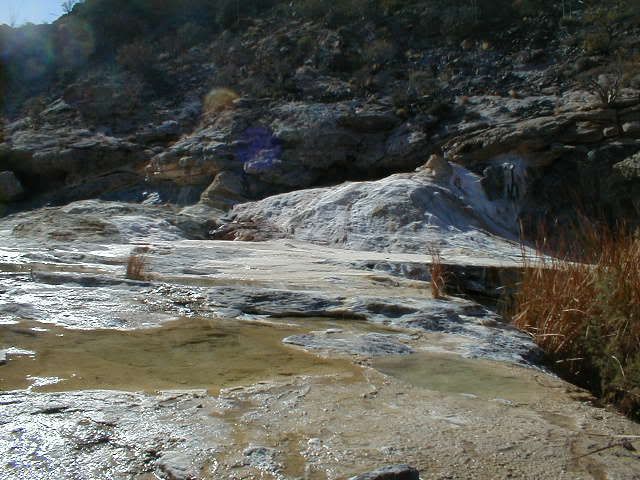
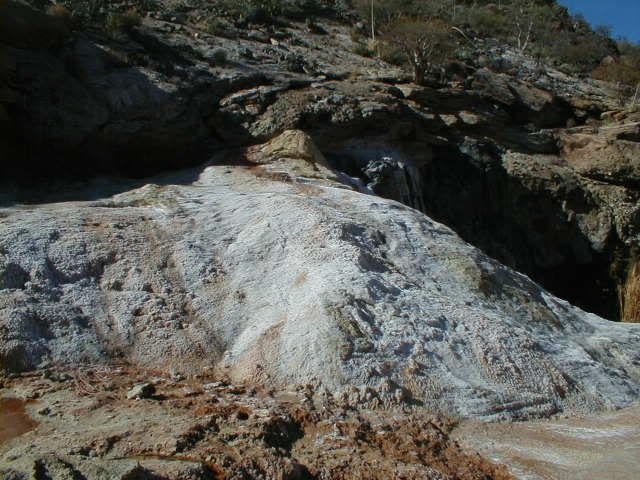
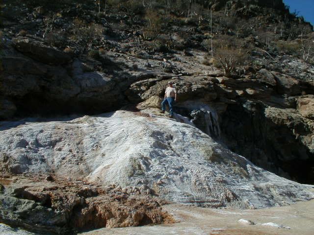
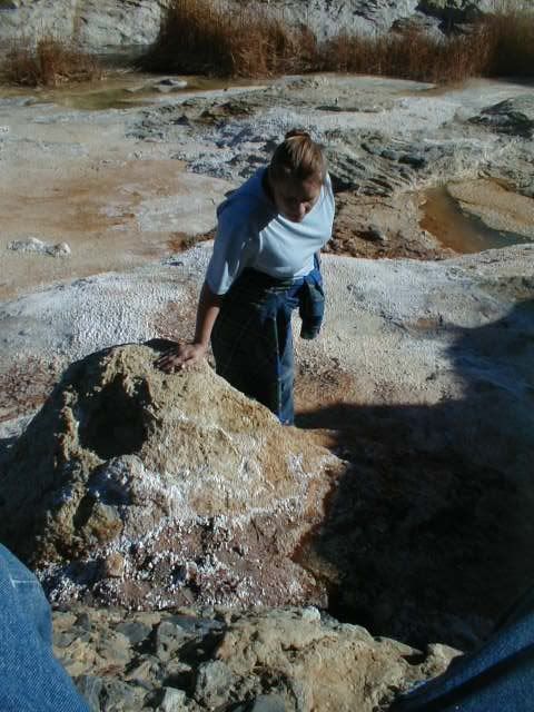
Here is El Volcán, up close... and on top. It is along the right hand side of the arroyo gorge, about 1/2 mile hike south from the road crossing. You
can see it easily on Google Earth, too. These photos are from 2006. More from 2011 in a blog page I made then: http://vivabajablog.blogspot.com/2011/07/lost-mission-expedi...
[Edited on 11-18-2015 by David K]
|
|
|
David K
Honored Nomad
Posts: 65587
Registered: 8-30-2002
Location: San Diego County
Member Is Offline
Mood: Have Baja Fever
|
|
Baja Lou's trip report of the hike down Arroyo El Volcán to search for a lost mission in 2011: http://forums.bajanomad.com/viewthread.php?tid=52928
Here is Part 1 of our huge, detailed trip report from 2011: http://forums.bajanomad.com/viewthread.php?tid=52696
Loads of photos and video clips of the bubbling soda springs at El Volcán included. We were having a fun search to find a point that a Nomad thought
could be ruins of the Lost Mission of Santa Isabel!
------------------------------------------------------------------------------------------------------
Most of us first saw El Volcán on a map in the 1962-1970 editions of the Lower California Guidebook:
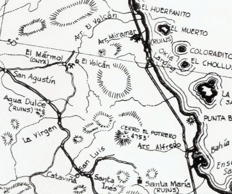
Or the newer 1975 'Baja California Guidebook' that included the new highway:
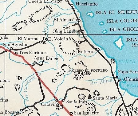
You may see that the Mexican topo maps (and Baja Almanac map) have the arroyo misnamed as "Zamora" and another minor arroyo is misnamed El Volcán.
Click on this picture and it becomes a short video with sound of the bubbling spring at El Volcán:

[Edited on 11-18-2015 by David K]
|
|
|
AKgringo
Elite Nomad
Posts: 6366
Registered: 9-20-2014
Location: Anchorage, AK (no mas!)
Member Is Offline
Mood: Retireded
|
|
Oh no....More maps!
Just kidding DK. This is a perfect example of a question that I would never think to ask, but someone did, and you have great answers right away.
Thank you!
If you are not living on the edge, you are taking up too much space!
"Could do better if he tried!" Report card comments from most of my grade school teachers. Sadly, still true!
|
|
|
Maron
Nomad
Posts: 458
Registered: 4-14-2014
Member Is Offline
|
|
WOW, David what detail and wonderful pictures. You are a very helpful fountain of info.
|
|
|
David K
Honored Nomad
Posts: 65587
Registered: 8-30-2002
Location: San Diego County
Member Is Offline
Mood: Have Baja Fever
|
|
The pleasure is mine... Baja is such an amazing place and El Volcán is one of the truly special Baja 'natural wonders'. If you have not yet, do click
on the links I added above to see some awesome photos and read some neat stories of our adventures.
In 2011, we had a great Baja Nomad group expedition: The late bajalou, TW (TMW now) and his brother Bill, XRPhlang, dtbushpilot, BAJACAT, El Vergel
and I were trying to find the lost mission of Santa Isabel using 'elbeau's Google Earth images.
|
|
|
motoged
Elite Nomad
Posts: 6481
Registered: 7-31-2006
Location: Kamloops, BC
Member Is Offline
Mood: Gettin' Better
|
|
David,
Good pics and enough maps ( i.e not a "ton" of them).
My first trip into El Marmol was in '94 by moto. Went past the school house to a quarry area and chatted with an older fellow (gringo)who was there
picking up rocks for his garden (he said).
I guess you could say I saw the El Marmol geezer spouting 
Don't believe everything you think....
|
|
|
David K
Honored Nomad
Posts: 65587
Registered: 8-30-2002
Location: San Diego County
Member Is Offline
Mood: Have Baja Fever
|
|
They are the only maps with a point called El Volcán on them. At least that I could post easily. Glad you enjoyed them.
|
|
|
wilderone
Ultra Nomad
Posts: 3914
Registered: 2-9-2004
Member Is Offline
|
|
Past the geiser site toward the gulf? Past Olividada mine? The road to the mine is now graded wide and busy with large dusty trucks rumbling through,
all the way from El Marmol. The pools of water in the drainage below the geiser are being sucked up with hoses. You should go and let us know the
latest in that area. I refuse to go there since it's been trashed like this. Past the mine, might be interesting, and you can drive to the mine.
|
|
|
Aldervale
Junior Nomad
Posts: 95
Registered: 12-22-2013
Member Is Offline
|
|
any thanks for the info.
The new barite mine operations means we will probably take a pass on El Marmol this trip.
There are a few other mines or places named Marmol.
I would like to find a reasonably easy to access Turquesa mine but needs to be hike able.
We have an old Toyota T100 and try not to abuse it.
Thanks again.
Aldervale
|
|
|
David K
Honored Nomad
Posts: 65587
Registered: 8-30-2002
Location: San Diego County
Member Is Offline
Mood: Have Baja Fever
|
|
| Quote: Originally posted by Aldervale | any thanks for the info.
The new barite mine operations means we will probably take a pass on El Marmol this trip.
There are a few other mines or places named Marmol.
I would like to find a reasonably easy to access Turquesa mine but needs to be hike able.
We have an old Toyota T100 and try not to abuse it.
Thanks again.
Aldervale |
What are you seeking? The La Olvidiada barite mine is 10 miles from El Marmol and has no effect on visiting El Marmol or enjoying El Volcan (unless
you are unable to drive off the graded road and up Arroyo el Volcan to park)?
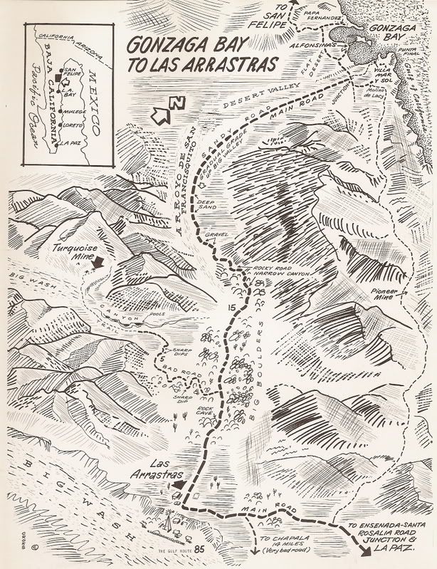
Now you are asking about turquoise mines? That's no problem either. There is one you can drive a 4WD to or a 2WD within a mile maybe... It is just
south of the end of pavement, south of Gonzaga Bay. La Turquesa Canyon and the Green Pools... Just search Nomad.
|
|
|
David K
Honored Nomad
Posts: 65587
Registered: 8-30-2002
Location: San Diego County
Member Is Offline
Mood: Have Baja Fever
|
|
I bumped up a long running thread on the turquoise mine and the 4WD route between Hwy. 1 and 5 there.
Here are the mileages south from Gonzaga with the turquoise mine road:
Total (and partial) mileages from San Luis Gonzaga
00.0 (0.0) Rancho Grande Store, Gonzaga (across from Pemex)
01.2 (1.2) Campo Beluga and El Sacrificio road
04.9 (3.7) Arroyo Santa Maria
07.2 (2.3) Las Palmitas/Santa Maria Canyon road
09.7 (2.5) Punta Final road
14.6 (4.9) La Turquesa road <<<
18.4 (3.8) Las Arrastras road
22.1 (3.7) Coco's Corner
34.8 (12.7) Hwy. 1, Laguna Chapala
This was pre-pavement, but should be very close since the pavement is over the same road the first 12 miles south.
From 1970:
[Edited on 11-19-2015 by David K]
|
|
|
ehall
Super Nomad
Posts: 1906
Registered: 3-29-2014
Location: Buckeye, Az
Member Is Offline
Mood: It's 5 o'clock somewhere
|
|
we need to set up a game camera to catch an eruption.
|
|
|
David K
Honored Nomad
Posts: 65587
Registered: 8-30-2002
Location: San Diego County
Member Is Offline
Mood: Have Baja Fever
|
|
That would be cool... 
|
|
|
4x4abc
Ultra Nomad
Posts: 4456
Registered: 4-24-2009
Location: La Paz, BCS
Member Is Offline
Mood: happy - always
|
|
there has never been a sign that water had been sprayed around anytime back. I think it is one of the many mineral springs (like in Calamajue canyon)
slowly bubbling out water. Creating onyx in the process. They all tend to choke themselves over their lifespan. Sometimes finding a new outlet close
by. Like the massive onyx field north of Santa Isabel. The water now coming out at Santa Isabel.
Harald Pietschmann
|
|
|
David K
Honored Nomad
Posts: 65587
Registered: 8-30-2002
Location: San Diego County
Member Is Offline
Mood: Have Baja Fever
|
|
Where is this Santa Isabel you mention?
The geyser eruption is described in Peterson's Baja Adventure Book.
|
|
|
4x4abc
Ultra Nomad
Posts: 4456
Registered: 4-24-2009
Location: La Paz, BCS
Member Is Offline
Mood: happy - always
|
|
La Visitacion - Santa Isabel - Agua del Mezquitito
Harald Pietschmann
|
|
|
4x4abc
Ultra Nomad
Posts: 4456
Registered: 4-24-2009
Location: La Paz, BCS
Member Is Offline
Mood: happy - always
|
|
Walt Peterson claims that the water shoots about once a month - but he does not report eyewitnessing it.
Harald Pietschmann
|
|
|
David K
Honored Nomad
Posts: 65587
Registered: 8-30-2002
Location: San Diego County
Member Is Offline
Mood: Have Baja Fever
|
|
He may have read an earlier accounting of it. When I am back home, I will look for it.
|
|
|
Gulliver
Senior Nomad
Posts: 651
Registered: 11-18-2013
Member Is Offline
|
|
I stared down that hole for an hour a few years ago. No action. Much laughter from Barbara. She had hopes of me getting a squirt in the eye.
|
|
|
| Pages:
1
2 |


