| Pages:
1
2
3
4 |
PaulW
Ultra Nomad

Posts: 3009
Registered: 5-21-2013
Member Is Offline
|
|
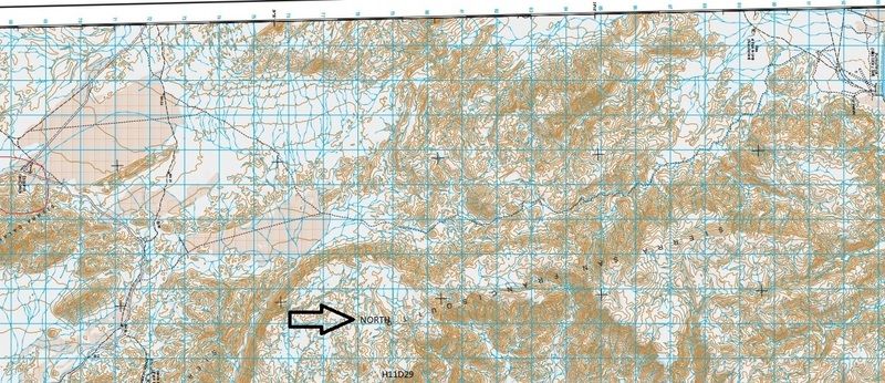
INEGI Topo Image
Road near Cocos to Punta Final
|
|
|
toronja
Nomad
Posts: 134
Registered: 2-1-2015
Location: Eugene, OR
Member Is Offline
|
|
I did check out 4x4abc's photos, David. From that sequence, we would not be comfortable tackling the rocky stretches between Punta Final and the
mine... There were not any particularly gnarly photos in the photo set after the mine visit, so my question was whether the south end of the road was
less difficult. Or perhaps the photos after that are of the west side of the loop before paving? I couldn't tell where they ended their journey.
|
|
|
David K
Honored Nomad
Posts: 64490
Registered: 8-30-2002
Location: San Diego County
Member Is Offline
Mood: Have Baja Fever
|
|
Paul's topo map section
That's the same road as in the maps I posted and in Harald's photos. It is 14.4 miles from Molino de Lacy south to the original Puerto Calamajué/ Las
Arrastras road, according to Howard Gulick in the 1958 edition of his Lower California Guidebook... when the Pioneer Mine road was the main road south
from Gonzaga Bay (in 1956), although the west side of the mountain road was also open then.
[Edited on 3-10-2016 by David K]
|
|
|
David K
Honored Nomad
Posts: 64490
Registered: 8-30-2002
Location: San Diego County
Member Is Offline
Mood: Have Baja Fever
|
|
Quote: Originally posted by toronja  | | I did check out 4x4abc's photos, David. From that sequence, we would not be comfortable tackling the rocky stretches between Punta Final and the
mine... There were not any particularly gnarly photos in the photo set after the mine visit, so my question was whether the south end of the road was
less difficult. Or perhaps the photos after that are of the west side of the loop before paving? I couldn't tell where they ended their journey.
|
You would be correct that the south road in and out of the Pioneer Mine would be the easier route. The Pioneer to Molino de Lacy section must be the
rockier, more deserted section. When I headed south of Molino de Lacy in 2002, I traveled 2.5 miles before the rocks got big enough to drive over
slowly, I turned around to spend more time exploring other areas.
[Edited on 3-10-2016 by David K]
|
|
|
4x4abc
Ultra Nomad
Posts: 4166
Registered: 4-24-2009
Location: La Paz, BCS
Member Is Offline
Mood: happy - always
|
|
the south end of the Pioneer mine road is super easy
the new gold mine is no longer new and now abandoned
even when it was active, it did never block the Pioneer mine road
Harald Pietschmann
|
|
|
toronja
Nomad
Posts: 134
Registered: 2-1-2015
Location: Eugene, OR
Member Is Offline
|
|
Thanks, gentlemen! I hope we get the chance to give it a try next time we're down, we haven't explored that area much.
|
|
|
PaulW
Ultra Nomad
Posts: 3009
Registered: 5-21-2013
Member Is Offline
|
|
Wow, such an interesting thread. I guess I will have to head down there and check out the roads. For sure its is more interesting than the paved road
these days.
If the pavement gets a little further south maybe we can find the Turquesia road turn off? If anyone finds it please post the coordinates.
|
|
|
David K
Honored Nomad
Posts: 64490
Registered: 8-30-2002
Location: San Diego County
Member Is Offline
Mood: Have Baja Fever
|
|
| Quote: Originally posted by PaulW | Wow, such an interesting thread. I guess I will have to head down there and check out the roads. For sure its is more interesting than the paved road
these days.
If the pavement gets a little further south maybe we can find the Turquesia road turn off? If anyone finds it please post the coordinates.
|
Paul, I have posted it...
Here you go, where La Turquesa Canyon road meets dirt Hwy. 5 (not necessarily the paved route when it reaches this point): 29º34.36', -114º22.01'
|
|
|
PaulW
Ultra Nomad
Posts: 3009
Registered: 5-21-2013
Member Is Offline
|
|
| Quote: Originally posted by David K | | Quote: Originally posted by PaulW | Wow, such an interesting thread. I guess I will have to head down there and check out the roads. For sure its is more interesting than the paved road
these days.
If the pavement gets a little further south maybe we can find the Turquesia road turn off? If anyone finds it please post the coordinates.
|
Paul, I have posted it...
Here you go, where La Turquesa Canyon road meets dirt Hwy. 5 (not necessarily the paved route when it reaches this point): 29º34.36', -114º22.01'
|
====
No, the new road erases your place. We need a new place. I could not even find the traditional coords. Lots pf changes thereabouts.
|
|
|
David K
Honored Nomad
Posts: 64490
Registered: 8-30-2002
Location: San Diego County
Member Is Offline
Mood: Have Baja Fever
|
|
Well... you just need to find a way off the new road once it reaches that area and it will be very close, naturally. The fun part is if they put up
the stupid barb wire fence along both sides blocking all existing side roads from the highway.
|
|
|
BajaRat
Super Nomad
Posts: 1302
Registered: 3-2-2010
Location: SW Four Corners / Bahia Asuncion BCS
Member Is Offline
Mood: Ready for some salt water with my Tecate
|
|
| Quote: Originally posted by PaulW | | Quote: Originally posted by David K | | Quote: Originally posted by PaulW | Wow, such an interesting thread. I guess I will have to head down there and check out the roads. For sure its is more interesting than the paved road
these days.
If the pavement gets a little further south maybe we can find the Turquesia road turn off? If anyone finds it please post the coordinates.
|
Paul, I have posted it...
Here you go, where La Turquesa Canyon road meets dirt Hwy. 5 (not necessarily the paved route when it reaches this point): 29º34.36', -114º22.01'
|
====
No, the new road erases your place. We need a new place. I could not even find the traditional coords. Lots pf changes thereabouts.
|
Me and The Fam had a heck of a time locating the access road to La Turquesa last Nov after the new concrete under hwy drains were poured. The original
access started in an arroyo which is now an overpass. A new track will have to be cut down the edge of the arroyo from the North after nipping the
fence up on the flat. Gonna take some time unless someone can convince the construction crew to do a 20 min D9 project before they move on. Just some
of the sad casualties of the hwy 5 paving project.
Lionel 
|
|
|
spikemd
Junior Nomad
Posts: 38
Registered: 10-4-2013
Member Is Offline
|
|
Looks like a cool road. Heading to Punta Final in a few weeks. Are the mines worth exploring? We will have a group of land rovers looking for some
adventures.
|
|
|
StuckSucks
Super Nomad
Posts: 2307
Registered: 10-17-2013
Member Is Offline
|
|
Here's a photo sphere I took next to the turn-off to the turquoise mine on Highway 5.
|
|
|
PaulW
Ultra Nomad
Posts: 3009
Registered: 5-21-2013
Member Is Offline
|
|
Boy it sure does not look like that now.
|
|
|
willardguy
Elite Nomad
Posts: 6451
Registered: 9-19-2009
Member Is Offline
|
|
it used to be marked by a car hood....man that camera shot that you can pan around and in and out is sure swanky! 
|
|
|
norte
Super Nomad
Posts: 1163
Registered: 10-8-2008
Member Is Offline
|
|
| Quote: Originally posted by David K | | Well... you just need to find a way off the new road once it reaches that area and it will be very close, naturally. The fun part is if they put up
the stupid barb wire fence along both sides blocking all existing side roads from the highway. |
Hey I figured you for a property rights kind of guy. Are you only a conservative when you are in the States? Fencing in private property is a
right, not a privilege.
|
|
|
TMW
Select Nomad
Posts: 10659
Registered: 9-1-2003
Location: Bakersfield, CA
Member Is Offline
|
|
The fence along the side of the highway is not a private property issue. If there are roads to private property the state or feds will let you cut the
wire for access, or they will do it. I think the fence is to keep large animals off the Hwy, like cows.
|
|
|
David K
Honored Nomad
Posts: 64490
Registered: 8-30-2002
Location: San Diego County
Member Is Offline
Mood: Have Baja Fever
|
|
A paved road doesn't magically turn the desert into private property. In fact, the fence blocks any property owners from accessing their land. So, for
the respect of land owners and taxpayers alike: Mr. Highway builder, tear down this fence!
|
|
|
rts551
Elite Nomad
Posts: 6699
Registered: 9-5-2003
Member Is Offline
|
|
| Quote: Originally posted by David K | | A paved road doesn't magically turn the desert into private property. In fact, the fence blocks any property owners from accessing their land. So, for
the respect of land owners and taxpayers alike: Mr. Highway builder, tear down this fence! |
Taxpayers? land owners? which are you to make this demand?
For your info, most of the land on either side of the road is Private Property. Some to ranches. Some to Ejidos. Some to large land developers.
As states above by TMW, if the Landowner, and only the landowner, wishes to put in a gate they are allowed to.
In this case, Norte has it right. What right do you have to trespass?
|
|
|
bajatrailrider
Super Nomad
Posts: 2423
Registered: 1-24-2015
Location: Mexico
Member Is Offline
Mood: Happy
|
|
Again RTS and Nerdy the real estate lawyers.Give it a rest , baja works little different. Everywhere in baja,when the state.Builds a new fence. They
block old existing roads,somehow they get gates. Just a fact of life.What right do you have to call anybody trespasser. You don't own it now do you.
|
|
|
| Pages:
1
2
3
4 |


