| Pages:
1
2
3 |
Ateo
Elite Nomad

Posts: 5914
Registered: 7-18-2011
Member Is Offline
|
|
Nice report Mulege C. Gracias.
|
|
|
Stewwalker
Newbie
Posts: 19
Registered: 11-4-2018
Member Is Offline
|
|
So is the most traveled road the west most road via El Datil? Planning on driving it in a few weeks.
Quote: Originally posted by David K  | 
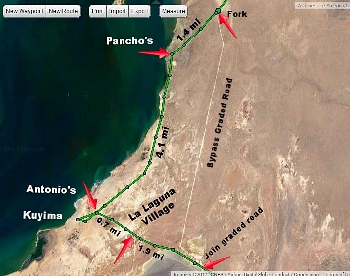
Here's my GPS track with mileages from San Juanico to El Datil:
El Datil north to the junction with the high road:
At Laguna San Ignacio:
----------------------------------------------------------------------------------------------------------------
|
|
|
|
David K
Honored Nomad
Posts: 65234
Registered: 8-30-2002
Location: San Diego County
Member Is Offline
Mood: Have Baja Fever
|
|
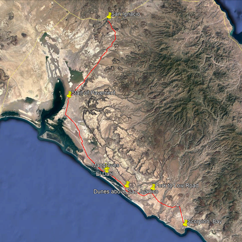
Stewwalker, when I did the trip (detailed on my maps above) it was August 2017. The El Datil/ Low or Salinas Road was the preferred route because the
High Road had numerous washouts reported.
The year after my trip, Desert Bull reported that the High Road was repaired and regraded, offering super-fast speeds.
Now, I hear the high road is not so fast, once again... so it is 50/50 on which to use. The High Road is a tiny bit shorter but the Low Road is
smoother... You just need to stay to the desert side of the salt flats and don't short cut across (mud danger) if you go that way.
There is sometimes a third route mentioned, but I can't help you with where it is in relation to the the two I have shown.
|
|
|
Howard
Super Nomad
Posts: 2353
Registered: 11-13-2007
Location: Loreto/Manhattan Beach/Kona
Member Is Offline
Mood: I'd rather regret the things I've done than regret the things I haven't done.
|
|
So for us map challenged people, how many miles/KM is it from the lagoon to San Juanico? I only have around a 100 miles range in my RZR and could
always bring spare gas. From S.J. all the way to the town of San Ignacio, is there anyone regularly selling gas and to really be fussy, hi octane?
Like I said, I can always bring spare gas but it's a matter of how much to bring.
Anyone have mileage from the gas station at Highway #1 to S.J.? By memory, they sell at least regular octane in S.J., correct?
We don't stop playing because we grow old;
we grow old because we stop playing
George Bernard Shaw
|
|
|
David K
Honored Nomad
Posts: 65234
Registered: 8-30-2002
Location: San Diego County
Member Is Offline
Mood: Have Baja Fever
|
|
| Quote: Originally posted by Howard | So for us map challenged people, how many miles/KM is it from the lagoon to San Juanico? I only have around a 100 miles range in my RZR and could
always bring spare gas. From S.J. all the way to the town of San Ignacio, is there anyone regularly selling gas and to really be fussy, hi octane?
Like I said, I can always bring spare gas but it's a matter of how much to bring.
Anyone have mileage from the gas station at Highway #1 to S.J.? By memory, they sell at least regular octane in S.J., correct?
|
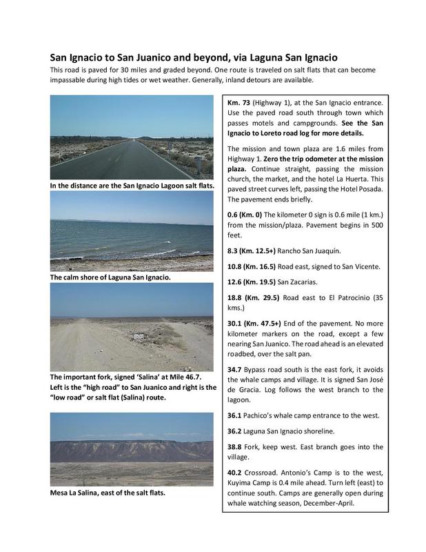
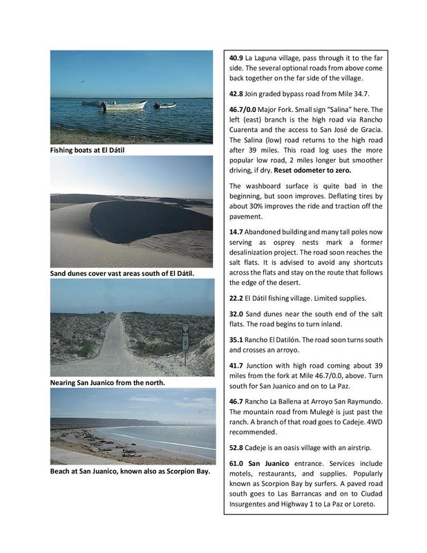
The maps go with my road logs... So here are the road log pages for San Ignacio to San Juanico. In a nutshell: San Ignacio to the lagoon is 36 miles
and the Lagoon to San Juanico is 70 miles. Gas for sale was signed at El Datil in 2017.
|
|
|
Howard
Super Nomad
Posts: 2353
Registered: 11-13-2007
Location: Loreto/Manhattan Beach/Kona
Member Is Offline
Mood: I'd rather regret the things I've done than regret the things I haven't done.
|
|
Thank you for the mileage.
We don't stop playing because we grow old;
we grow old because we stop playing
George Bernard Shaw
|
|
|
AKgringo
Elite Nomad
Posts: 6174
Registered: 9-20-2014
Location: Anchorage, AK (no mas!)
Member Is Offline
Mood: Retireded
|
|
What are you driving? Some vehicles do better than others on the flats.
If you are not living on the edge, you are taking up too much space!
"Could do better if he tried!" Report card comments from most of my grade school teachers. Sadly, still true!
|
|
|
chippy
Super Nomad
Posts: 1744
Registered: 2-2-2010
Member Is Offline
|
|
| Quote: Originally posted by Howard | So for us map challenged people, how many miles/KM is it from the lagoon to San Juanico? I only have around a 100 miles range in my RZR and could
always bring spare gas. From S.J. all the way to the town of San Ignacio, is there anyone regularly selling gas and to really be fussy, hi octane?
Like I said, I can always bring spare gas but it's a matter of how much to bring.
Anyone have mileage from the gas station at Highway #1 to S.J.? By memory, they sell at least regular octane in S.J., correct?
|
When I was there (San Juanico) in nov. my brother bought gas there. It was regular/verde but we never asked for hi/rojo. I bought diesel there also.
[Edited on 3-1-2020 by chippy]
|
|
|
TMW
Select Nomad
Posts: 10659
Registered: 9-1-2003
Location: Bakersfield, CA
Member Is Offline
|
|
According to SCORE race notes it is approx. 105 miles from the PEMEX station on Hwy 1 in San Ignacio to where the road curves left at San Juanico.
Note this is going thru El Datil or using the salt flat road.
[Edited on 3-1-2020 by TMW]
|
|
|
JZ
Select Nomad
Posts: 12600
Registered: 10-3-2003
Member Is Online
|
|
I'm going to trace a route of the Low Road on GE in a bit. Will posted it later.
|
|
|
Stewwalker
Newbie
Posts: 19
Registered: 11-4-2018
Member Is Offline
|
|
The chase truck is a Raptor.
|
|
|
JZ
Select Nomad
Posts: 12600
Registered: 10-3-2003
Member Is Online
|
|
Here is a track of the Low Road. I mapped it trying to stay East as much as possible, where it looked like dryer areas.
Let me know if any errors. I've been up to Dunes above Scorpion Bay before, so up to there should be good.
Attachment: Scorpion Bay to San Ignacio.kmz (7kB)
This file has been downloaded 379 times
[Edited on 3-2-2020 by JZ]
[Edited on 3-4-2020 by BajaNomad]
|
|
|
mtgoat666
Select Nomad
Posts: 19654
Registered: 9-16-2006
Location: San Diego
Member Is Offline
Mood: Hot n spicy
|
|
| Quote: Originally posted by JZ | Here is a track of the Low Road. I mapped it trying to stay West as much as possible where it looked like dryer areas.
Let me know if any errors. I've been up to Dunes above Scorpion Bay before, so up to there should be good.

[Edited on 3-2-2020 by JZ] |
Classic baja nomad bs. You haven’t been there, but you post a route map based on satellite photo you found on the internet, and you chose the
“dry-looking” roads 
[Edited on 3-2-2020 by mtgoat666]
[Edited on 3-4-2020 by BajaNomad]
Woke!
Hands off!
“Por el bien de todos, primero los pobres.”
“...ask not what your country can do for you – ask what you can do for your country.” “My fellow citizens of the world: ask not what America
will do for you, but what together we can do for the freedom of man.”
Pronoun: the royal we
|
|
|
JZ
Select Nomad
Posts: 12600
Registered: 10-3-2003
Member Is Online
|
|
| Quote: Originally posted by mtgoat666 |
Classic baja nomad bs. You haven’t been there, but you post a route map based on satellite photo you found on the internet, and you chose the
“dry-looking” roads
|
Maybe you missed the KMZ? It's mapped from GE by following the road tracks, not an internet photo you retard. Then did a screen shot. Already had
the first 30 miles from a previous trip.
I map out the tracks on GE of every trail we are going to hit before we take a trip. Export them to Back Country Navigator with offline HD satellite
imagery. It's like watching your truck drive live on GE.
Gonna do this route next month.
[Edited on 3-2-2020 by JZ]
|
|
|
geoffff
Senior Nomad
Posts: 709
Registered: 1-15-2009
Member Is Offline
|
|
| Quote: Originally posted by JZ | | I map out the tracks on GE of every trail we are going to hit before we take a trip. Export them to Back Country Navigator with offline HD satellite
imagery. It's like watching your truck drive live on GE. |
I do something very similar. Super fun to watch yourself from above!
-- Geoff
|
|
|
Mulege Canuck
Nomad
Posts: 393
Registered: 11-27-2016
Member Is Offline
|
|
I would not recommend anyone doing that low road without a track or a plotted route before you head out. Lots of turns and junctions.
Last year we missed a turn and ended up on the “middle road” which is sugar sand. I was surfing the F350 and was very lucky to not get stuck or
meet an on coming vehicle.
I use a navionics app to plot routes. I use the app for sailing my boat in BC off Vancouver Island but it works well in Baja for off-road stuff.
When in doubt, go walk any shortcut across the mud or just play it safe and meander along the tidal edge.
|
|
|
Mulege Canuck
Nomad
Posts: 393
Registered: 11-27-2016
Member Is Offline
|
|
| Quote: Originally posted by Mulege Canuck | I would not recommend anyone doing that low road without a track or a plotted route before you head out. Lots of turns and junctions.
Last year we missed a turn and ended up on the “middle road” which is sugar sand. I was surfing the F350 and was very lucky to not get stuck or
meet an on coming vehicle.
I use a navionics app to plot routes. I use the app for sailing my boat in BC off Vancouver Island but it works well in Baja for off-road stuff.
When in doubt, go walk any shortcut across the mud or just play it safe and meander along the tidal edge. |

|
|
|
JZ
Select Nomad
Posts: 12600
Registered: 10-3-2003
Member Is Online
|
|
It is incredibly cool! Blows my mind, cool.
|
|
|
Mulege Canuck
Nomad
Posts: 393
Registered: 11-27-2016
Member Is Offline
|
|
| Quote: Originally posted by Mulege Canuck | I would not recommend anyone doing that low road without a track or a plotted route before you head out. Lots of turns and junctions.
Last year we missed a turn and ended up on the “middle road” which is sugar sand. I was surfing the F350 and was very lucky to not get stuck or
meet an on coming vehicle.
I use a navionics app to plot routes. I use the app for sailing my boat in BC off Vancouver Island but it works well in Baja for off-road stuff.
When in doubt, go walk any shortcut across the mud or just play it safe and meander along the tidal edge. |

|
|
|
Desertbull
Senior Nomad
Posts: 558
Registered: 8-27-2003
Member Is Offline
|
|
The path of least resistance is still the High Road via San Jose de Gracia road ... 2WD in my 20 year old Toyota Tundra easy peasy.
As Mulege Canuck says you better have the latest file from someone trust worthy ... I've towed many out of the tidal flat mud and the deep sand when
they made the wrong turn ...
Every super moon changes the low tidal flats route ... and that was 2 weeks ago, pay attention, school is in session.
DREAM IT! PLAN IT! LIVE IT!
|
|
|
| Pages:
1
2
3 |


