| Pages:
1
2
3
..
5 |
micah202
Super Nomad

Posts: 1615
Registered: 1-19-2011
Location: vancouver,BC
Member Is Offline
|
|
Bahia de Los Angeles,, must see's, etc?
Can't believe it,, I've been hitting Baja since the 80's,, haven't been to BOLA yet.
....What are the highlights, must see's, best places to eat, and recommended boondocking sites by the sea?
La Gringa is the place to be?
Fuel is reliable in BOLA?
Cave paintings,,, I know guides are required, what's the $ and time budget for a good excursion,, and who are recommended guides, where to find them?
And what of the possibility of whale excursions out of BOLA? I know of course GN and Ignacio are more sure for that, but also there's other whales
to see in Cortez, but are the prospects of sewing a whale actually worth
it on the Cortez side?
What about the road out to the south? ....BOLA- Bahia San Rafael-Rancho Piedra Blanca-'hwy18', out to Guerro Negro... Suitable for a raised Toyota
Sienna, truck tires, with seasoned driver? Is there a reasonable amount of traffic, 5-10/day, 'just in case' we get stuck? How many driving hours
to get out that way to Guerro Negro?
Mucho Gracias for any suggestions, ideas. <;~]
[Edited on 1-16-2020 by micah202]
|
|
|
NE14Baja
Junior Nomad
Posts: 56
Registered: 8-14-2008
Member Is Offline
|
|
Look up Ricardo Arce in BOLA, he runs a dive company there.
He will also take you on tours of the bay and islands, you will likely see an abundance of see creatures while on your tour. Blue whales, fin whales,
whale sharks, dolphins, sea turtles and fish boils were all seen while on our tour.
You can look him up on the net and read reviews and get info.
Boon docking available at LA Gringa, camping at Archelon or Daggets.
Side trip to the mission in San Borja is nice. Museum in town is cool too.
|
|
|
wilderone
Ultra Nomad
Posts: 3779
Registered: 2-9-2004
Member Is Offline
|
|
Get out to Animas Bay; look for the indigenous stone walls west there (lots of info on this forum). I kayaked and camped on Isla La Ventana and Isla
Coronado - no fish for snorkeling. A little hiking on Isla Coronado. Are you camping? I did not like Daggetts for camping - too many cars and quads
coming past kicking up the dust; gringos with their dogs running loose on the beach. La Gringa might be more peaceful. Hang out at the old "Docs"
south of town, and ask if the whale sharks have been spotted. Camped there once, and feeding dolphins came every morning about10 yards off shore.
Take the back road to San Borja mission - ask the caretaker family as a guide. Ask if they will allow you to use the warm springs (it's private
property). Interesting hiking around there. En route to San Borja on that road there are some geoglyphs - keep an eye out for them (they cross the
road, or rather, the road goes right through).
|
|
|
micah202
Super Nomad
Posts: 1615
Registered: 1-19-2011
Location: vancouver,BC
Member Is Offline
|
|
just got a U2U,,, reminded me of the beautiful adventure which is Baja...
| Quote: | Hola, we’re heading to Las Animas on the 1-21 crossing in Mexicali.
If you down during that time frame maybe we can keep an eye out for you on the dirt road south of BOLA |
That's the great thing about Baja, we all keep an eye out for each other!
I remember back in the early 80's, the 'peurtecitos highway' was a sign, and a terrifyingly long dirt road. I got totally stuck at one point, hadn't
seen a car all day,,, but some locals appeared within 5 minutes,, wouldn't accept any 'gratitudes' for their help!
|
|
|
micah202
Super Nomad
Posts: 1615
Registered: 1-19-2011
Location: vancouver,BC
Member Is Offline
|
|
Nice suggestions folks, keep 'em coming! The title will long serve as a useful search for others.
I camp from my Sienna, bring kayak and small sailboat on the roof. I'm immediately drawn to la Gringa for the excellent wave protection from the
Norte winds.
...that'd be way cool to spend time on the islands, we'll see.
Nice details in your posts folks,,, Whale sharks would be amazing!
...and Hot Springs too!? I'll add it to an old thread I started... 'the Hot Springs ' thread.
...any further leads on San Borja? ..km's to south? Not finding anything..... and Animas Bay? I see Animas Ecolodge to the south, I'm
guessing that's the place for some picto's you mention.
Quote: Originally posted by wilderone  | Get out to Animas Bay; look for the indigenous stone walls west there (lots of info on this forum).
I kayaked and camped on Isla La Ventana and Isla Coronado - no fish for snorkeling. A little hiking on Isla Coronado.
Are you camping? I did not like Daggetts for camping - too many cars and quads coming past kicking up the dust; gringos with their dogs running loose
on the beach. La Gringa might be more peaceful. Hang out at the old "Docs" south of town, and ask if the whale sharks have been spotted. Camped
there once, and feeding dolphins came every morning about10 yards off shore.
......Take the back road to San Borja mission - ask the caretaker family as a guide. Ask if they will allow you to use the warm springs (it's private
property). Interesting hiking around there.
...... En route to San Borja on that road there are some geoglyphs - keep an eye out for them (they cross the road, or rather, the road goes right
through). |
[Edited on 1-16-2020 by micah202]
|
|
|
JZ
Elite Nomad
Posts: 9268
Registered: 10-3-2003
Member Is Offline
|
|
Suggestions:
- day trip or camp at Ensenada Alcatraz. 29.161269° -113.613994°. Go out towards MX1 about 20 miles then up the dry lake bed, then West to the
coast. Beautiful beach up there. I'll post a track later. Easy drive with a truck.
- day trip or camping at Bahia las Animas. Or stop there for a day/night on the way to San Fransquito
- rent a super panga and spend a night or two in the bay at the top of Isla Ángel de la Guarda at Puerto Refugio. The most beautiful bay in the Sea
of Cortez. Watch this video to see it: https://youtu.be/g3ThXCm3XSA
- rent a panga (2500 pesos) and go explore the islands in the bay and go over to Rincon. Rincon is the best beach in Bahia de los Angeles by a very
wide margin. Beautiful white sand. 28.913807° -113.471214°.
- La Gringa has some rocky beaches. We've found better beaches just before the pavement ends on the way out to La Gringa. Just after all the sprawl
on the beach stops. I think you could camp there. We go there to hang out at night for a few hours sometimes. You can drive the entire length of
the beach once you get down to the water.
We always make a fire on the beach. The market on the West side of the main drag has tons of firewood. A whole pile out back.
|
|
|
micah202
Super Nomad
Posts: 1615
Registered: 1-19-2011
Location: vancouver,BC
Member Is Offline
|
|
Nice deets with co-ordinates!
Animas is the first bay south of BOLA bay?
Where's the Panga rental, or is it pretty obvious?
Is a panga different than a 'super' panga?
All these things to do and see,,,,, how's the groceries, ice in BOLA,, pretty well stocked for 800peops, no need to provision elsewhere??
| Quote: Originally posted by JZ | Suggestions:
- day trip or camp at Ensenada Alcatraz. 29.161269° -113.613994°. Go out towards MX1 about 20 miles then up the dry lake bed, then West to the
coast. Beautiful beach up there. I'll post a track later. Easy drive with a truck.
- day trip or camping at Bahia las Animas. Or stop there for a day/night on the way to San Fransquito
- rent a super panga and spend a night or two in the bay at the top of Isla Ángel de la Guarda at Puerto Refugio. The most beautiful bay in the Sea
of Cortez. Watch this video to see it: https://youtu.be/g3ThXCm3XSA
- rent a panga (2500 pesos) and go explore the islands in the bay and go over to Rincon. Rincon is the best beach in Bahia de los Angeles by a very
wide margin. Beautiful white sand. 28.913807° -113.471214°.
- La Gringa has some rocky beaches. We've found better beaches just before the pavement ends on the way out to La Gringa. Just after all the sprawl
on the beach stops. I think you could camp there. We go there to hang out at night for a few hours sometimes. You can drive the entire length of
the beach once you get down to the water.
We always make a fire on the beach. The market on the West side of the main drag has tons of firewood. A whole pile out back.
|
[Edited on 1-16-2020 by micah202]
|
|
|
David K
Honored Nomad
Posts: 64490
Registered: 8-30-2002
Location: San Diego County
Member Is Offline
Mood: Have Baja Fever
|
|
Everything you seek is here on Nomad...
My trip reports from researching for the road guide are from 2017 and 2018, but still can give you lot's a details:
In fact, I have shared my Road guide Part 3 which covers L.A. Bay and San Borja, here on Nomad: http://forums.bajanomad.com/viewthread.php?tid=91898
These trip reports cover L.A. Bay, San Borja, the road down and out via El Arco (Hwy. 18)...
Trip Report 1: http://forums.bajanomad.com/viewthread.php?tid=85374
Trip Report 2: http://forums.bajanomad.com/viewthread.php?tid=85756
Trip Report 5: http://forums.bajanomad.com/viewthread.php?tid=86781
All my maps are here: http://forums.bajanomad.com/viewthread.php?tid=88771
[Edited on 1-16-2020 by David K]
|
|
|
JZ
Elite Nomad
Posts: 9268
Registered: 10-3-2003
Member Is Offline
|
|
Diaz has pretty cheap pangas. Great for running around in the bay. For the big super panga with a tower go to Guillermos. You can hike some of the
islands. Especially this one: 28.999439° -113.513450°. At the top you can see the entire bay.
Both panga shops are right by the launch ramps near the Southwest side of town.
Bahia de Las Animas is here: 28.822618° -113.364675°.
I have tracks for all the various places.
|
|
|
micah202
Super Nomad
Posts: 1615
Registered: 1-19-2011
Location: vancouver,BC
Member Is Offline
|
|
| Quote: Originally posted by JZ | Diaz has pretty cheap pangas. Great for running around in the bay. For the big super panga with a tower go to Guillermos. You can hike some of the
islands. Especially this one: 28.999439° -113.513450°. At the top you can see the entire bay.
Both panga shops are right by the launch ramps near the Southwest side of town.
Bahia de Las Animas is here: 28.822618° -113.364675°.
I have tracks for all the various places.
|
hummm, how to use the geo-co-ordinates? I tried google maps. 
|
|
|
micah202
Super Nomad
Posts: 1615
Registered: 1-19-2011
Location: vancouver,BC
Member Is Offline
|
|
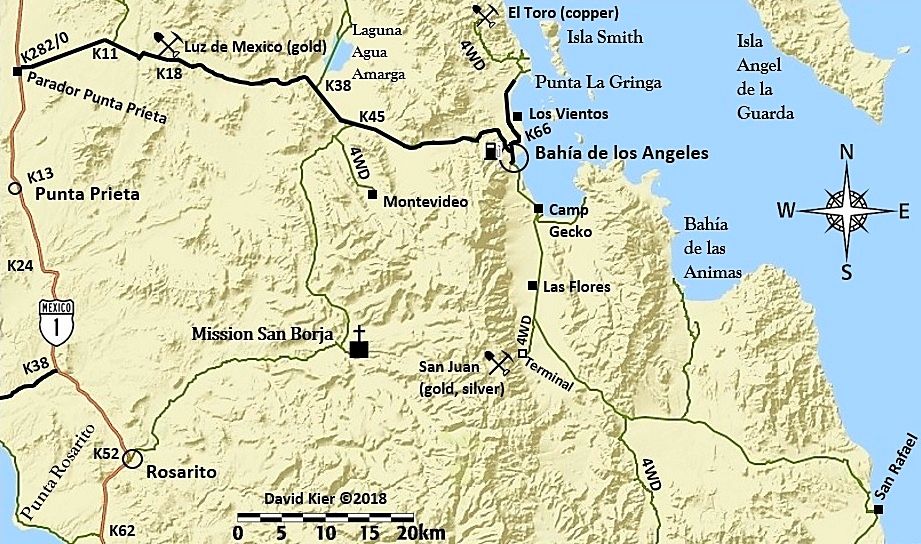
hah, you answered my next question in here I bet. Certainly the request for a map. I had only seen the road going south from BOLA, past Camp Gecko
and Las Flores,,, out to 1 south of Guerro Negro,,, that's more rugged I suppose?
|
|
|
David K
Honored Nomad
Posts: 64490
Registered: 8-30-2002
Location: San Diego County
Member Is Offline
Mood: Have Baja Fever
|
|
It is a 2WD graded highway from L.A. Bay south to Punta San Francisquito and then west to El Arco and Hwy. 1.
|
|
|
JZ
Elite Nomad
Posts: 9268
Registered: 10-3-2003
Member Is Offline
|
|
Install Google Earth Pro on to your computer (or phone/tablet). C/P the coordinates into the search.
You can use Google Earth online, I just like the Pro better.
|
|
|
JZ
Elite Nomad
Posts: 9268
Registered: 10-3-2003
Member Is Offline
|
|
Some tips:
1. Install a GPS app on our phone.
Back Country Navigator is my favorite, but Android only. Gaia is great and works with all phones. This is a must have. When ppl give you tracks,
you can down load them right to your phone or tablet. It's like Google Maps for dirt roads.
This works w/o having cell coverage as long as you download the maps ahead of time. Topo or Satellite views. Top requires MUCH less data and
downloads very fast. Satellite view is awesome though.
Put it this way, I have what David just posted above on my phone in either Topo or Satellite versions. When we are driving it shows us on the map.
Same for when out on the water. We can see what bays to hit.
2. Download Google Maps for offline use in Baja.
This allows you to use it w/o cell coverage. Great for the paved roads.
[Edited on 1-17-2020 by JZ]
|
|
|
micah202
Super Nomad
Posts: 1615
Registered: 1-19-2011
Location: vancouver,BC
Member Is Offline
|
|
ahh, so the markings of '4WD' are outdated?
| Quote: Originally posted by David K | | It is a 2WD graded highway from L.A. Bay south to Punta San Francisquito and then west to El Arco and Hwy. 1. |
|
|
|
micah202
Super Nomad
Posts: 1615
Registered: 1-19-2011
Location: vancouver,BC
Member Is Offline
|
|
When you say 'Pro tips' here,, are you relating it to GooglePro, in your post above? It seems to be 2 apps you're suggesting,, Google Pro, and Back
Country Navigator?
| Quote: Originally posted by JZ | Pro tips:
1. Install a GPS app on our phone.
Back Country Navigator is my favorite, but Android only. Gaia is great and works with all phones. This is a must have. When ppl give you tracks,
you can down load them right to your phone or tablet. It's like Google Maps for dirt roads.
This works w/o having cell coverage as long as you download the maps ahead of time. Topo or Satellite views. Top requires MUCH less data and
downloads very fast. Satellite view is awesome though.
Put it this way, I have what David just posted above on my phone in either Topo or Satellite versions. When we are driving it shows us on the map.
Seem for when out on the water. We can see what bays to hit.
2. Download Google Maps for offline use in Baja.
This allows you to use it w/o cell coverage. Great for the paved roads.
[Edited on 1-16-2020 by JZ] |
|
|
|
JZ
Elite Nomad
Posts: 9268
Registered: 10-3-2003
Member Is Offline
|
|
No.
|
|
|
micah202
Super Nomad
Posts: 1615
Registered: 1-19-2011
Location: vancouver,BC
Member Is Offline
|
|
...but Google Pro and GPS Navigator are 2 different app you're suggesting,,yes? 
|
|
|
JZ
Elite Nomad
Posts: 9268
Registered: 10-3-2003
Member Is Offline
|
|
Google Earth Pro - for use on your laptop. Allows you to study Baja on satellite images. Zoom in on dirt roads, check out bays and beaches. Plug in
coordinates from ppl to see where it is. Add way points. Build your own tracks. Import tracks from others. Export tracks and waypoints to GPS
phone apps (see below).
Back Country Navigator or Gaia - GPS apps for phones with either Topo or Satelite imagery. Allows you to record your own tracks. Or import
tracks/waypoints you have made on Google Earth. Or import tracks you get from other ppl. Tracks are typically in KMZ or GPX format.
Google Maps - the app you use every day. It allows you to download maps for offline use (i.e. no cell service). You can download all of Baja. Great
for when driving on the pavement.
|
|
|
micah202
Super Nomad
Posts: 1615
Registered: 1-19-2011
Location: vancouver,BC
Member Is Offline
|
|
Ahh, got it,thanks
[quote=1177684&tid=93888&author=JZ]Google Earth Pro - for use on your laptop. Allows you to study Baja on satellite images. Zoom in on dirt
roads, check out bays and beaches. Plug in coordinates from ppl to see where it is. Add way points. Build your own tracks. Import tracks from
others. Export tracks and waypoints to GPS phone apps (see below).
Back Country Navigator or Gaia - GPS apps for phones with either Topo or Satelite imagery. Allows you to record your own tracks. Or import
tracks/waypoints you have made on Google Earth. Or import tracks you get from other ppl. Tracks are typically in KMZ or GPX format.
Google Maps - the app you use every day. It allows you to download maps for offline use (i.e. no cell service). You can download all of Baja. Great
for when driving on the pavement.
[/rquote]
|
|
|
| Pages:
1
2
3
..
5 |


