| Pages:
1
2
3 |
David K
Honored Nomad

Posts: 64490
Registered: 8-30-2002
Location: San Diego County
Member Is Offline
Mood: Have Baja Fever
|
|
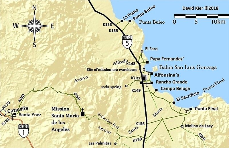
When I zoom in real close, using satellite and INEGI maps:
Leon Grande (mine camp, end of road): 29.0284, -114.2547 or
29°01' 42.3"N, 114°15'16.8" W
Agua Leon (spring, end of road): 29.1705, -114.2294 or
29°10'13.8"N, 114°13'45.8"W
|
|
|
bajaric
Senior Nomad
Posts: 605
Registered: 2-2-2015
Member Is Offline
|
|
Let's talk about Leon Grande, the spring. This was a water hole mentioned in Howard Hale's book Long Road to Mulege. Great little book for Baja
history buffs.
We can all agree that in 1921 Hale was traveling south on foot from Laguana Chapala with a friend and two burros. They missed the water hole at "Aqua
Leon" and continued south where they made a dry camp at the base of the eastern slopes of the Sierra Columbia. Down to their last few sips of water,
they heard the faint sound of singing. They went towards the sound until they came upon a Mexican road building crew that were camped at a spring.
The spring was called Leon Grande.
Hale described the spring as near the end of a partially built road that went east towards Bahia de Los Angeles.
The next day they traveled 15 km south along a "well defined trail", crossing a wide plain and some low ridges before arriving at a graded road to
Punta Prieta.
All of this would indicate that Leon Grande, the spring, is shown by Haralds coordinates for "Manantial Las Palomas - Leon Grande"
[Edited on 12-10-2021 by bajaric]
|
|
|
David K
Honored Nomad
Posts: 64490
Registered: 8-30-2002
Location: San Diego County
Member Is Offline
Mood: Have Baja Fever
|
|
Ric, what do you call this place, then?
29°01' 42.3"N, 114°15'16.8"W
I am hoping geoffff makes a map with all these places with GPS waypoints, so we can be clear on what is what.
Thank you!
|
|
|
geoffff
Senior Nomad
Posts: 643
Registered: 1-15-2009
Member Is Offline
|
|
I'm on it 
|
|
|
geoffff
Senior Nomad
Posts: 643
Registered: 1-15-2009
Member Is Offline
|
|
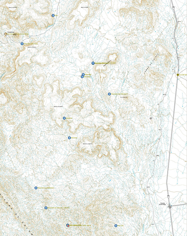
It's plotting some lines for the road route that really interests me, but here is a map of the Mina and Manantial waypoints being discussed above.
Click to enlarge:
|
|
|
geoffff
Senior Nomad
Posts: 643
Registered: 1-15-2009
Member Is Offline
|
|
Waypoints as Google Earth KMZ:
Manantial-waypoints.kmz
|
|
|
4x4abc
Ultra Nomad
Posts: 4165
Registered: 4-24-2009
Location: La Paz, BCS
Member Is Offline
Mood: happy - always
|
|
sometime after 2005 someone built a field along the Arroyo
29° 9'50.74"N, 114°13'55.28"W
south of Agua Leon
Harald Pietschmann
|
|
|
David K
Honored Nomad
Posts: 64490
Registered: 8-30-2002
Location: San Diego County
Member Is Offline
Mood: Have Baja Fever
|
|
Thanks Geoffff...
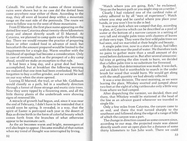
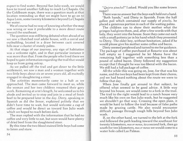
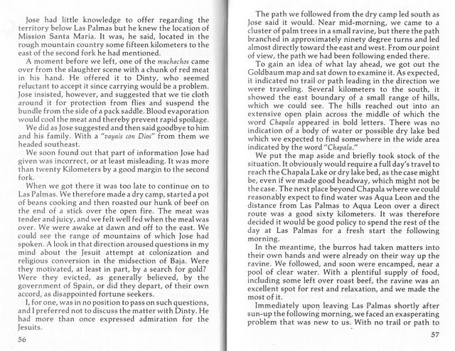
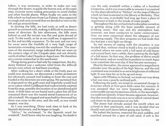
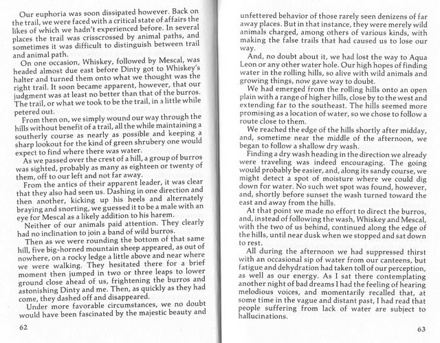
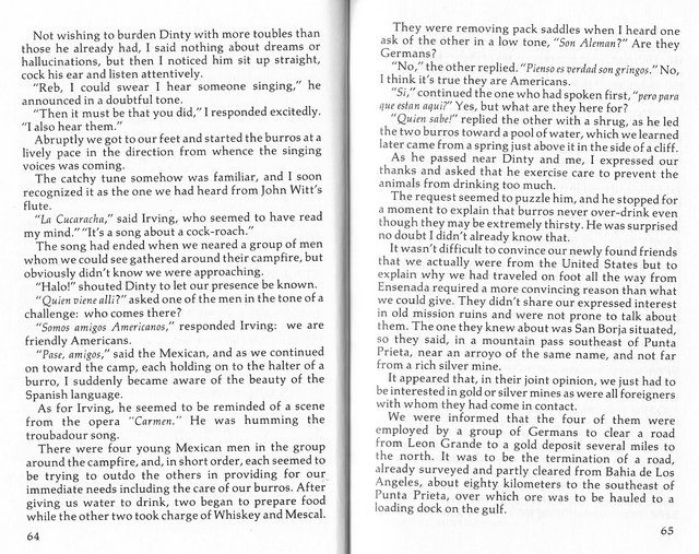
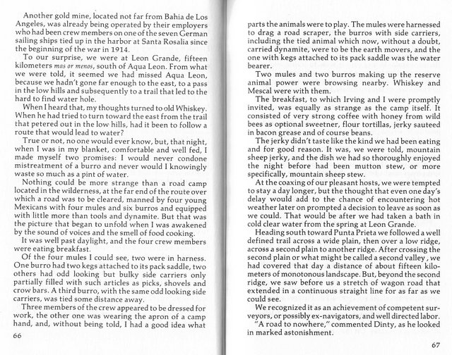
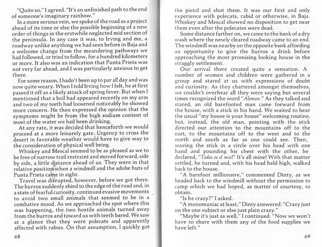
Let me help a bit by sharing some pages from the book, 'Long Walk to Mulegé' by Howard Hale, published in 1980.
The book is about a walk made in 1921 with his navy buddy ('Dinty') and two burros (Whiskey & Mescal)! They were most interested in the missions
during their journey, too.
These fellows had met with David Goldbaum, in Ensenada, who mapped the entire north half of the peninsula just a few years earlier.
I will scan the pages from when they left El Mármol until they arrived at Punta Prieta (pages 52-69), both well-known location today. Many of the
other places may only be found of Goldbaum's map... but reading the words may help us place these locations on today's maps or sat images.
I am hoping a Nomad with more energy than I (geoffff?) will plot their trail based on the details here. Remember, they had Goldbaum's map (and so do
we: https://collections.lib.uwm.edu/digital/collection/agdm/id/3... )

|
|
|
4x4abc
Ultra Nomad
Posts: 4165
Registered: 4-24-2009
Location: La Paz, BCS
Member Is Offline
Mood: happy - always
|
|
what an exciting story!
those guys were all over
I guess in the early years you needed luck on your side to be a pioneer.
I have tried to make sense of their descriptions on Google Earth
now I am lost
the straight track taking off somewhere towards the end is intriguing
I think, I found it.
Harald Pietschmann
|
|
|
David K
Honored Nomad
Posts: 64490
Registered: 8-30-2002
Location: San Diego County
Member Is Offline
Mood: Have Baja Fever
|
|
Quote: Originally posted by 4x4abc  | what an exciting story!
those guys were all over
I guess in the early years you needed luck on your side to be a pioneer.
I have tried to make sense of their descriptions on Google Earth
now I am lost
the straight track taking off somewhere towards the end is intriguing
I think, I found it.
|
*Google Earth lacks place names or historic names. Shows the mountains and arroyos exactly, however.
*Old maps with historic names lack accuracy in placement.
** The fun is combining the two (historic place names and accurate locations). I hope geoffff is having some fun! 
|
|
|
David K
Honored Nomad
Posts: 64490
Registered: 8-30-2002
Location: San Diego County
Member Is Offline
Mood: Have Baja Fever
|
|
| Quote: Originally posted by Lance S. | | Remember Hale was writing from memory some 60 years after the fact. His book was published 9 years after the Goldbaum map was published in Towns of
Baja California. Apparently he was using the Goldbaum map to try and reconstruct his journey. The Goldbaum map is sometimes distorted, an east west
trail can appear to run north south for instance. Trying to figure out his route may be pointless. |
Well, yes... maybe... He may have had the manuscript written years before he actually printed it in 1980?
|
|
|
David K
Honored Nomad
Posts: 64490
Registered: 8-30-2002
Location: San Diego County
Member Is Offline
Mood: Have Baja Fever
|
|
If I don't ask, then maybe Geoffff will...
Thank you.
|
|
|
4x4abc
Ultra Nomad
Posts: 4165
Registered: 4-24-2009
Location: La Paz, BCS
Member Is Offline
Mood: happy - always
|
|
here is what i found
the directions and distances given are very much "mas o menos"
more or less - kinda
very Mexican
Arroyo San Julio is the one going through Catavina
they expected it 60 km to the south
the advice at the rancho past Catavina not to take the open plain route was correct, as there is absolutely no water
BUT - it is going straight (fast) towards where they wanted to be
instead they were sent scrambling over the hills to Las Palmas
that is a tough one
they somehow missed all the dry lakes (Laguna Chapala, Laguna El Islote)
that helped me to determine their route
they also missed the water at Calamajue and some other sources along the way
they made some strange choices
reading this account and knowing where things are makes you squirm in your seat
like reading Graham's first book
you are constantly thinking "Why is he doing that? And not XYZ?"
crossing strong animal tracks is not wise
they always lead to water
well, they missed Agua Leon
loved the mention of the road crew for the German Road
there are indeed remnants of straight shoots to Bahia de los Angeles
plus some ghost lines (I'll explain later what that is)
the account shows how important accurate maps (with correct names) are
if needed, the guys could have followed their burros to water
humans have lost that ability
likely trip below
Attachment: crazy trip.kmz (3kB)
This file has been downloaded 124 times
[Edited on 4-16-2023 by 4x4abc]
Harald Pietschmann
|
|
|
4x4abc
Ultra Nomad
Posts: 4165
Registered: 4-24-2009
Location: La Paz, BCS
Member Is Offline
Mood: happy - always
|
|
Valle - Cañada - Cañon - Arroyo - Rio
in that order
Arroyo is the channel the water (Rio) runs in
anyway, the point is that Arroyo San Julio is not 60 km to the south of Catavina
Harald Pietschmann
|
|
|
David K
Honored Nomad
Posts: 64490
Registered: 8-30-2002
Location: San Diego County
Member Is Offline
Mood: Have Baja Fever
|
|
Wow, Harald... interesting KMZ map!
So their 'Las Palmas' is what you think is today's 'Las Palmitas just west of Punta Final on the El camino Real? Interesting!
I have been there a couple times, and it is sure tucked into a box canyon... no trail to the west that I could see... and I even hiked beyond the
palms looking. Ahhh, but that was eons ago (1999)! LOL
Las Palmitas Oasis (west of Km. 159, today)
|
|
|
4x4abc
Ultra Nomad
Posts: 4165
Registered: 4-24-2009
Location: La Paz, BCS
Member Is Offline
Mood: happy - always
|
|
I put a lot of thought into this
the first rancho the guys ran into is most likely San Ignacito
Santa Ines is also a possibility
their first camp may have been where the Catavina cave is, not the present community. That makes Rancho Santa Ines a possibility
three numbers were given at this location
15 km to Mision Santa Maria (fits Santa Ines and San Ignacito)
20 km for the first leg of the march (fits Santa Ines, not so much San Ignacito)
10 km for the 2nd leg of the march (might fit both as we don't know where this change of direction happened)
at no point any of the dry lakes are crossed/mentioned (Laguna El Caporal, Laguna El Islote, Laguna Chapala) - that means the guys were traveling east
of Laguna Chapala
they did not follow the trail To Mision Santa Maria
they would have found water or seen the Mision - they didn't
going towards Pedregal they would have found water before Laguna Chapala
that water hole has no palm trees and they did not cross Chapala
No idea why they did not find water at San Francisquito ot Arrastras and they obviously did not hit Calamajue (they would have found water - even in a
bad year)
the route I chose between Laguna Chapala and Calamajue is an established route - today often used by bike groups
I still have it on my calendar to bring a 4x4 through there
looks doable

[Edited on 12-12-2021 by 4x4abc]
Harald Pietschmann
|
|
|
David K
Honored Nomad
Posts: 64490
Registered: 8-30-2002
Location: San Diego County
Member Is Offline
Mood: Have Baja Fever
|
|
I am enjoying this... Maybe when I get a chance, I will print each line with a new direction/ location mention and then we can put a pushpin onto the
map of where we think they are?
I have some other projects I am in the middle of, but this is fascinating.
|
|
|
John Harper
Super Nomad
Posts: 2289
Registered: 3-9-2017
Location: SoCal
Member Is Offline
|
|
This is an excellent thread.
John
|
|
|
4x4abc
Ultra Nomad
Posts: 4165
Registered: 4-24-2009
Location: La Paz, BCS
Member Is Offline
Mood: happy - always
|
|
if these guys used the Goldbaum "map" they were definitely effed (David does not like strong words)
several key locations are in the wrong position - all at least a day's walk off
in the old days that could have killed you

Harald Pietschmann
|
|
|
4x4abc
Ultra Nomad
Posts: 4165
Registered: 4-24-2009
Location: La Paz, BCS
Member Is Offline
Mood: happy - always
|
|
around San Borja
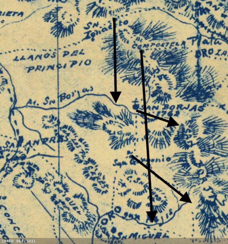
Harald Pietschmann
|
|
|
| Pages:
1
2
3 |


