| Pages:
1
2
3
4 |
Lance S.
Nomad

Posts: 158
Registered: 2-16-2021
Member Is Offline
|
|
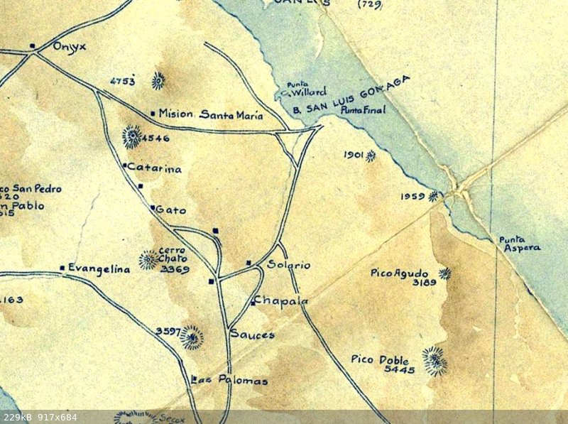
Where the heck did that map come from? Awesome!
I think the other Pozo Solorio is La Turquesa (or Las Arrastras),I could of course be wrong but it lines up well with that old mine road over the
divide from near Rinconada.
Rinconada 29°29'36"N 114°29'09"W
A trail junction. You could go west to El Gato or Jaraguacito, east to La Turquesa, north to San Ignacito, or south to Pozo Chapala.
[Edited on 8-16-2022 by Lance S.]
|
|
|
AKgringo
Elite Nomad
Posts: 5820
Registered: 9-20-2014
Location: Anchorage, AK (no mas!)
Member Is Offline
Mood: Retireded
|
|
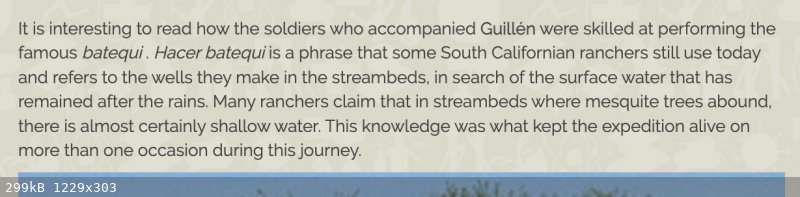
Batequi
Quote: Originally posted by Lance S.  |
It is a place where an arroyo meets the sea where you can dig for water at high tide. Fresh water is pushed up by the salt water. These water
holes were typically brackish but drinkable.
[Edited on 8-13-2022 by Lance S.] |
That is a word, and a concept that I have never heard before! 
If you are not living on the edge, you are taking up too much space!
"Could do better if he tried!" Report card comments from most of my grade school teachers. Sadly, still true!
|
|
|
Lance S.
Nomad
Posts: 158
Registered: 2-16-2021
Member Is Offline
|
|
| Quote: Originally posted by AKgringo | | Quote: Originally posted by Lance S. |
It is a place where an arroyo meets the sea where you can dig for water at high tide. Fresh water is pushed up by the salt water. These water
holes were typically brackish but drinkable.
[Edited on 8-13-2022 by Lance S.] |
That is a word, and a concept that I have never heard before!
|
I learned that from Homer Aschmann's The Central Desert of Baja California.
|
|
|
Lance S.
Nomad
Posts: 158
Registered: 2-16-2021
Member Is Offline
|
|
https://www.jstor.org/stable/20138415
|
|
|
Lance S.
Nomad
Posts: 158
Registered: 2-16-2021
Member Is Offline
|
|
| Quote: Originally posted by lencho | Where did you hear that word as referring to a water source? 
The only reference I can find is of a specific cave somewhere around Comondú with paintings inside.
Edit: Cross-posted with your answer. Does that book indicate where he got the word?
[Edited on 8-13-2022 by lencho] |
He doesn't say where he learned it. You can see it in other place names on the peninsula. There is also a Los Batequitos.
|
|
|
David K
Honored Nomad
Posts: 64507
Registered: 8-30-2002
Location: San Diego County
Member Is Online
Mood: Have Baja Fever
|
|
'Batiquitos' Lagoon is here in San Diego County between Leucadia and Carlsbad (La Costa Ave). I think Padre Crespi named it in 1769, heading for
Monterey from San Diego?
|
|
|
4x4abc
Ultra Nomad
Posts: 4182
Registered: 4-24-2009
Location: La Paz, BCS
Member Is Offline
Mood: happy - always
|
|
| Quote: Originally posted by Lance S. | Where the heck did that map come from? Awesome!
I think the other Pozo Solorio is La Turquesa, I could of course be wrong but it lines up well with that old mine road over the divide from near
Rinconada.
Rinconada 29°29'36"N 114°29'09"W
A trail junction. You could go west to El Gato or Jaraguacito, east to La Turquesa, north to San Ignacito, or south to Pozo Chapala.
[Edited on 8-13-2022 by Lance S.] |
1917 David Goldbaum map - has all mining claims in the north
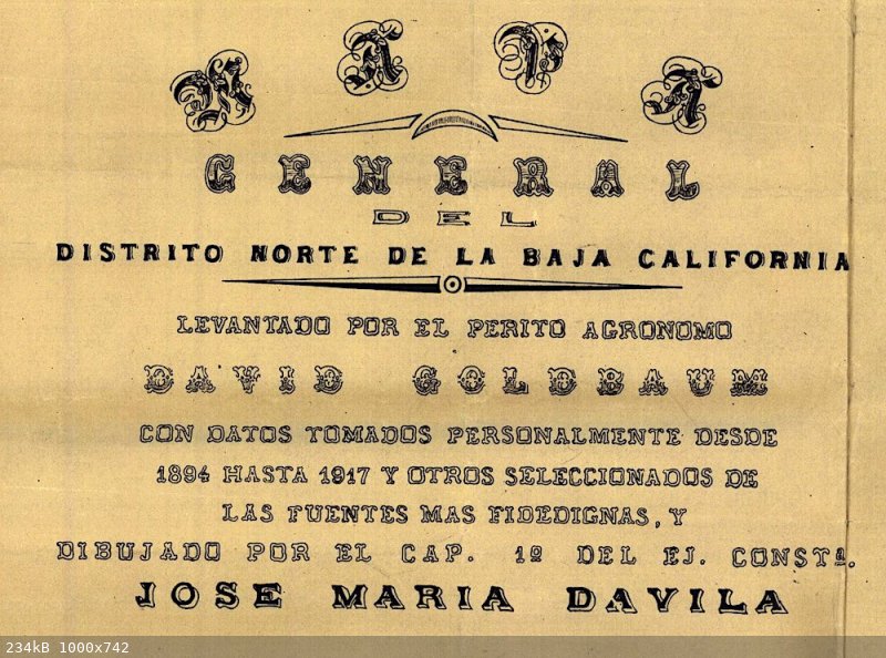
Harald Pietschmann
|
|
|
4x4abc
Ultra Nomad
Posts: 4182
Registered: 4-24-2009
Location: La Paz, BCS
Member Is Offline
Mood: happy - always
|
|
| Quote: Originally posted by Lance S. | Where the heck did that map come from? Awesome!
I think the other Pozo Solorio is La Turquesa, I could of course be wrong but it lines up well with that old mine road over the divide from near
Rinconada.
Rinconada 29°29'36"N 114°29'09"W
A trail junction. You could go west to El Gato or Jaraguacito, east to La Turquesa, north to San Ignacito, or south to Pozo Chapala.
[Edited on 8-13-2022 by Lance S.] |
you might be right
this 1915 Harris&Cromwell map shows it clearly
Harald Pietschmann
|
|
|
BajaRat
Super Nomad
Posts: 1302
Registered: 3-2-2010
Location: SW Four Corners / Bahia Asuncion BCS
Member Is Offline
Mood: Ready for some salt water with my Tecate
|
|
Strong work people
Best Nomad Thread in years
Love that piece of earth
Lionel 
|
|
|
4x4abc
Ultra Nomad
Posts: 4182
Registered: 4-24-2009
Location: La Paz, BCS
Member Is Offline
Mood: happy - always
|
|
| Quote: Originally posted by Lance S. |
Rinconada 29°29'36"N 114°29'09"W
A trail junction. You could go west to El Gato or Jaraguacito, east to La Turquesa, north to San Ignacito, or south to Pozo Chapala.
|
La Rinconada, km 213
29°31'11.16"N, 114°30'1.28"W
Harald Pietschmann
|
|
|
Lance S.
Nomad
Posts: 158
Registered: 2-16-2021
Member Is Offline
|
|
| Quote: Originally posted by 4x4abc | | Quote: Originally posted by Lance S. |
Rinconada 29°29'36"N 114°29'09"W
A trail junction. You could go west to El Gato or Jaraguacito, east to La Turquesa, north to San Ignacito, or south to Pozo Chapala.
|
La Rinconada, km 213
29°31'11.16"N, 114°30'1.28"W |
Perfect! Thank you for the correction. So the old mine road actually begins at La Rinconada. Cool. Now I can see how well the 1915 map
reflects the trail layout.
[Edited on 8-17-2022 by Lance S.]
|
|
|
David K
Honored Nomad
Posts: 64507
Registered: 8-30-2002
Location: San Diego County
Member Is Online
Mood: Have Baja Fever
|
|
| Quote: Originally posted by 4x4abc | | Quote: Originally posted by Lance S. | Where the heck did that map come from? Awesome!
I think the other Pozo Solorio is La Turquesa, I could of course be wrong but it lines up well with that old mine road over the divide from near
Rinconada.
Rinconada 29°29'36"N 114°29'09"W
A trail junction. You could go west to El Gato or Jaraguacito, east to La Turquesa, north to San Ignacito, or south to Pozo Chapala.
[Edited on 8-13-2022 by Lance S.] |
you might be right
this 1915 Harris&Cromwell map shows it clearly
|
Harald, can you please share the link or source of this map... It looks really beautiful! I hope the rest of the peninsula is included!
EDIT: Thank you Harald and Thank you 'geoffff' :
A super-zoom version is linked on https://vivabaja.com/maps/ (at 1915...)

[Edited on 8-15-2022 by David K]
|
|
|
mtgoat666
Select Nomad
Posts: 17357
Registered: 9-16-2006
Location: San Diego
Member Is Offline
Mood: Hot n spicy
|
|
| Quote: Originally posted by David K | From a paper, midway down many papers on geology and biology of Baja and the gulf:
https://www.academia.edu/15521074/Baja_California_oases_a_hi...
DISTRIBUTION OF CHAPARRAL AND PINE-OAK “SKY ISLANDS” IN CENTRAL AND SOUTHERN BAJA CALIFORNIA AND IMPLICATIONS OF PACK RAT MIDDEN RECORDS ON
CLIMATE CHANGE SINCE THE LAST GLACIAL MAXIMUM


FIGURE 3A (ABOVE).
Chaparral on Cerro San Luis in the Sierra La Asamblea.
Adenostoma fasciculatum
(chamise) in the foreground growing with taller
Pinus monophylla
. The Gulf of California is in the distance (photo courtesy of K. Geraghty).
FIGURE 3B (BELOW).
Resistant bedrock granite slope with
Quercus chrysolepis
,
Pinus monophylla
, and
Brahea armata
on the Sierra La Asamblea plateau (photo courtesy of K. Geraghty).
[Edited on 8-12-2022 by David K] |
Y’all should do a E-W traverse hike over the mountains, start at the highway, cross the range at the high point with pinyon, finish at the sea, get
picked up by a boat.
Woke!
“...ask not what your country can do for you – ask what you can do for your country.” “My fellow citizens of the world: ask not what America
will do for you, but what together we can do for the freedom of man.”
Prefered gender pronoun: the royal we
|
|
|
Lance S.
Nomad
Posts: 158
Registered: 2-16-2021
Member Is Offline
|
|
The other name, Sierra San Luis.
In 1765 linck could really begin working on getting the population to the north of San Borja, the territory that would become mission Calamajue,
ready for a mission. He called the territory San Luis. There was a place he called "this mission of San Luis", He did have supplies including
clothing sent for the neophytes. He also mentions a ranch nearby where horses were raised. In 1766 he doesn't mention a Mission of San Luis but he
does visit a rancheria by that name. It is the first water traveling north from Laguna Chapala to Aqua Dulce. Possibly San Ignacito or El Gato. The
chieftain of the rancheria would later become neophyte governor of Calamajue.
The territory sounds like a possible origin for the name. He does give the full name at one point as San Luis Gonzaga, so the territory was named
after the bay.
Lincks Reports and Letters (Burrus 1967)
Lincks 1766 expedition (Burrus 1966)
[Edited on 9-17-2022 by Lance S.]
[Edited on 12-24-2022 by Lance S.]
|
|
|
David K
Honored Nomad
Posts: 64507
Registered: 8-30-2002
Location: San Diego County
Member Is Online
Mood: Have Baja Fever
|
|
San Luis was often how they described Gonzaga Bay... It is Bahía SAN LUIS Gonzaga, after all!
Old Maps of the 1800s had the bay named simply 'San Luis' and with some confusion, the Jesuits would name a population center and future mission of
San Luis.
Perhaps not related, but an old rancho named San Luis was between Cataviña and Santa Ynez... It is still there, over-looking the palm arroyo on the
south side of the vado.
[Edited on 8-16-2022 by David K]
|
|
|
Lance S.
Nomad
Posts: 158
Registered: 2-16-2021
Member Is Offline
|
|
Ok so apparently a batequi is a water source that is not always available. The kind I described is one kind of batequi. It is an indigenous word
but from Sinaloa.
[Edited on 8-16-2022 by Lance S.]
|
|
|
4x4abc
Ultra Nomad
Posts: 4182
Registered: 4-24-2009
Location: La Paz, BCS
Member Is Offline
Mood: happy - always
|
|
about Batequi:
(right above the cross of Ligüi)
https://www.culcobcs.com/cultura-entretenimiento/23-dias-de-...
Harald Pietschmann
|
|
|
David K
Honored Nomad
Posts: 64507
Registered: 8-30-2002
Location: San Diego County
Member Is Online
Mood: Have Baja Fever
|
|
The photo in that article (of the cross at Ligüí) was mine from 2012.
The book of Padre Guillén's expeditions is quite interesting. He discover the future site of Mission Los Dolores Apaté, during his trek to La Paz to
help establish that mission in 1720.
In 1721, Guillén moved his mission (San Luis Bautista) from Ligüí (the location name was changed to Malibat by the new tribe who moved into that
area) to Apaté.
New financiang was available from a new benefactor, so the mission took on a new name with the move... Nuestra Señora de los Dolores Apaté (also
known as 'Dolores del Sur' to prevent confusion with an earlier named Dolores closer to Loreto that had breifly planned on becoming a mission).
So many odd facts ablout the missions that had confused earlier writers, is clarified in my book.
Here is the Ligüí marker cross photo of 2012. The mission foundation was washed away by an expanding arroyo. The last chunk af masonry from it, I
photographed in December 2001. The cross was erected about 500 feet from the original site and it too was washed away after the 2012 photo!

[Edited on 12-19-2022 by David K]
|
|
|
Lance S.
Nomad
Posts: 158
Registered: 2-16-2021
Member Is Offline
|
|
That's great stuff Harald, thanks for sharing.
|
|
|
Lance S.
Nomad
Posts: 158
Registered: 2-16-2021
Member Is Offline
|
|
Based on the paper David posted a link to, the coast live oak grow over here 29°19'13"N 114°06'25"W
I wonder if you can find the same kind of bedrock mortar milling stations associated with acorn processing farther north.
[Edited on 12-21-2022 by Lance S.]
|
|
|
| Pages:
1
2
3
4 |


