| Pages:
1
2
3 |
David K
Honored Nomad

Posts: 64491
Registered: 8-30-2002
Location: San Diego County
Member Is Offline
Mood: Have Baja Fever
|
|
Yes.
|
|
|
David K
Honored Nomad
Posts: 64491
Registered: 8-30-2002
Location: San Diego County
Member Is Offline
Mood: Have Baja Fever
|
|
Quote: Originally posted by 4x4abc  | I have 2 locations for San Juan:
Rancho San Juan 28°40'43.72"N, 113°40'25.44"W (seems newer)
and
Rancho Aguaje de San Juan 28°39'56.20"N, 113°36'1.61"W (historic location)
|
Very good, Harald... and here is the original old Rancho San Gregorio, of my photos above: 28°39'49"N, 113°39'55"W
|
|
|
David K
Honored Nomad
Posts: 64491
Registered: 8-30-2002
Location: San Diego County
Member Is Offline
Mood: Have Baja Fever
|
|
| Quote: Originally posted by lencho | | Quote: Originally posted by 4x4abc | is there any known water source at Los Remedios/Guadalupe?
why would the bay get the name "Remedy"?
remedy for what? |
Another thought: "Remedios" is also a person's name; I've seen the place labeled both as "Bahía de Remedios" and "Bahía de los Remedios", which
leaves room for thought.
Edit: While I was looking for background, I ran upon a couple of really cool documents from the Secretaría de Marina giving a lot of
navegation detail for both coasts of the peninsula:
West Coast
East Coast
|
VERY COOL links!! Thanks!
|
|
|
Lance S.
Nomad
Posts: 151
Registered: 2-16-2021
Member Is Offline
|
|
Is this Mina El Toro? 29°05'46"N 113°35'58"W If so then the Goldbaum map makes it look like Guadalupe is about here 29°07'34"N 113°34'56"W.
One of those places you could dig behind the shore in an arroyo for water? The water source for the El Toro mine?
Some more road closer to the gulf. 29°06'27"N 113°35'32"W
[Edited on 10-9-2022 by Lance S.]
|
|
|
David K
Honored Nomad
Posts: 64491
Registered: 8-30-2002
Location: San Diego County
Member Is Offline
Mood: Have Baja Fever
|
|
| Quote: Originally posted by Lance S. | Is this Mina El Toro? 29°05'46"N 113°35'58"W If so then the Goldbaum map makes it look like Guadalupe is about here 29°07'34"N 113°34'56"W.
One of those places you could dig behind the shore in an arroyo for water? The water source for the El Toro mine?
Some more road closer to the gulf. 29°06'27"N 113°35'32"W
[Edited on 10-9-2022 by Lance S.] |
That is the area of some of the copper mines and the trail to the ghost town and just past there, where the road V's into the right side of the slope.
See my article on El Toro for the abandoned village location: https://www.bajabound.com/bajaadventures/bajatravel/la_gring...
|
|
|
Lance S.
Nomad
Posts: 151
Registered: 2-16-2021
Member Is Offline
|
|
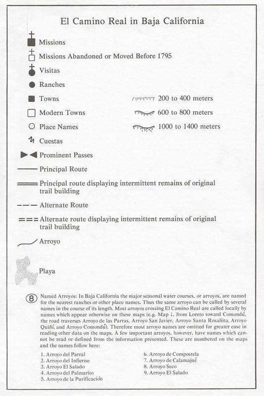
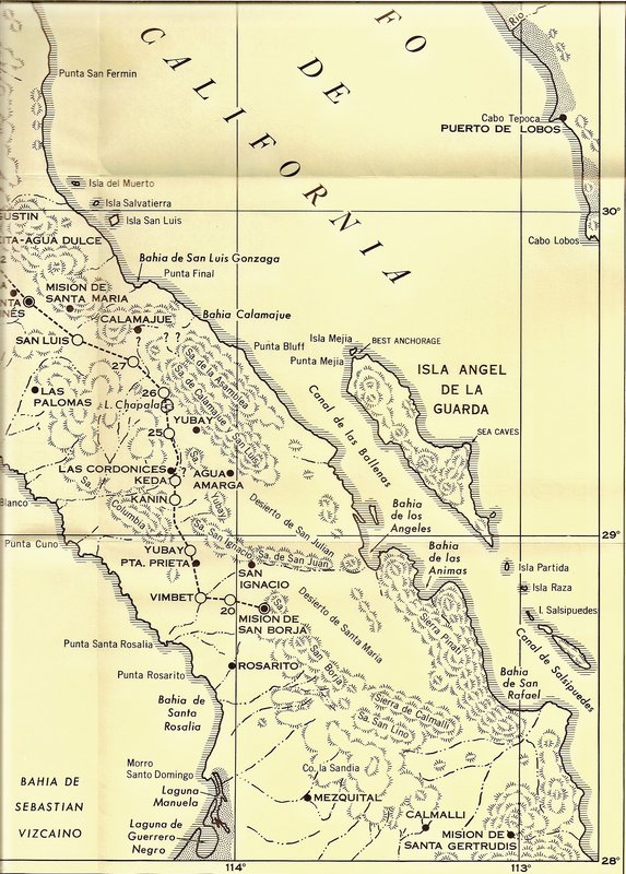
The legend is missing from this Crosby map. What does the symbol at Aguaje de San Juan mean? A church?
https://octopup.org/img/misc/davidk/ecr/ecr-maps-1.jpg
|
|
|
David K
Honored Nomad
Posts: 64491
Registered: 8-30-2002
Location: San Diego County
Member Is Offline
Mood: Have Baja Fever
|
|
Indeed it is! The map source also lacks a legend: https://web.archive.org/web/20160329012947/http://www.sandie...
Forthnately, I have the 1977 Winter Journel of San Diego History. Here is the legend:
|
|
|
Lance S.
Nomad
Posts: 151
Registered: 2-16-2021
Member Is Offline
|
|
Thank you for posting the legend. I trust Crosby has a good reason for placing it there instead of San Gregorio where the foundation stones are.
Here is a quote from Porcayo's paper on Calamajue.
"encuentran las numerosas rancherías donde habitaban una cantidad considerable deindígenas, como la de Calamajué o San Pedro y San Pablo, la
ranchería de Guadalupe (Carta deFermín Francisco de Lasuén a Francisco Palou), y la de San Luis Gonzaga."
Calamajue o San Pedro y San Pablo? Unfortunately there is no citation.
I was going through the register for San Borja more systematically and realized that San Pablo de Calagnujuet is mentioned so infrequently it must
just be people from there who happened to die at San Borja rather than being under that missions jurisdiction. The last mention is spring of 1772.
Santa Maria is mentioned two or three times as well.
https://www.academia.edu/38430811/La_Misi%C3%B3n_de_Calamaju...
[Edited on 10-14-2022 by Lance S.]
|
|
|
Lance S.
Nomad
Posts: 151
Registered: 2-16-2021
Member Is Offline
|
|
These are the settlements listed in the San Fernando register.
De la Casa - San Fernando
San Joseph/San Jose
Las Llagas
San Luis (Gonzaga)
San Juan de Dios
Any idea about Las Llagas?
[Edited on 12-2-2022 by Lance S.]
[Edited on 12-6-2022 by Lance S.]
|
|
|
David K
Honored Nomad
Posts: 64491
Registered: 8-30-2002
Location: San Diego County
Member Is Offline
Mood: Have Baja Fever
|
|
I sure hope you find out... The Franciscan's and the Dominican's reports and letters are hard to find. I think many were lost in the 1906 San
Francisco quake/ fire.
The best preserved Dominican records are in the 1960 Loyola University dissertation: The Domincan Mission Foundations in Baja California,
1769-1822 by Albert Bertrand Nieser.
Maybe followed by Zephyrin Engelhardt's The Missions and Missionaries of California, Vol. 1, Lower California, 1929. Engelhardt copied
mission records, stored in San Francisco before the quake/ fire.
I will review them both to see if these rancheria/pueblo/visita names appear in them.
Franciscan President Junípero Serra founded the mission of San Fernando de Velicatá in 1769 on his trek north from Loreto to San Diego. However, the
Franciscan handed off the peninsula mission field to the Dominicans in 1773, barely four years later. The adobe buildings we have seen in photos from
1905 (North) and later were likely all Dominican buildings, adding to or replacing the first huts and adobes erected there.
I detail this mission's history on pages 116-122 of my book.
|
|
|
David K
Honored Nomad
Posts: 64491
Registered: 8-30-2002
Location: San Diego County
Member Is Offline
Mood: Have Baja Fever
|
|
After reviewing Nieser's 1960 work, he focusses on the Dominican founded missions, not the previous ones they took over operating. I only see mention
of the padres assigned to San Fernando and how they had to deal with the Franciscan's at San Fernando, who wanted to take all the Baja mission's
supplies and artifacts for their Alta California missions.
One book published, from a Baja California Dominican, was Observations on California, 1772-1790 by Luis Sales. The only mention of San
Fernando (pages 100 & 181) was about the transfering Santa María to the new mission at Velicatá.
Engelhardt (in 1929) details the 'rancherias' (Indian settlements) of Mission San Fernando, in 1773 (on page 606) as: San Luis, Santa Rosa, San
Francisco, De Los Llagas, San Juan de Dios, Santo Domingo, and San Miguel.
Modern author, Michael Mathes, in his 1977 book, usually lists mission visitas for each. However, only San Juan de Dios is named for San Fernando.
[since Mission Santa María was still open until 1774 or 1775, I would not be certain that the San Luis mentioned is at the bay we call 'San Luis
Gonzaga' or 'Willard' today. However, the cargo trail west from Gonzaga Bay's mission warehouse went towards San Fernando, bypassing Santa María,
just to the north.]
|
|
|
David K
Honored Nomad
Posts: 64491
Registered: 8-30-2002
Location: San Diego County
Member Is Offline
Mood: Have Baja Fever
|
|
Thank you for the quest!
|
|
|
Lance S.
Nomad
Posts: 151
Registered: 2-16-2021
Member Is Offline
|
|
"Since Mission Santa María was still open until 1774 or 1775, I would not be certain that the San Luis mentioned is at the bay we call 'San Luis
Gonzaga' or 'Willard' today. However, the cargo trail west from Gonzaga Bay's mission warehouse went towards San Fernando, bypassing Santa María,
just to the north."
I totally agree. This is the place Linck calls the Mission of San Luis in 1765. It was what the "lost missions" of la Magdalena ,San Juan Bautista,
and Delores Del Norte were. It was between Laguna Chapala and Agua Dulce, likely San Ignacito. Maybe you could post that part of the 1766 Linck
expedition?
Del Barco reasons that la Magdalena was the first site of the mission that would become Santa Gertrudis. I think this is why INAH calls la Magdalena
a mission. By that reasoning San Luis would be the first site of the mission that would become Mission Santa Maria. A chunk of the population of San
Luis along with their leader were taken to Calamajue to found that Cabacera. Their leader Juan Nepumoceno became neophyte governor at Calamajue.
This demonstrates continuity between Lincks Mission of San Luis and Calamajue
Any way you look at it San Luis is an integral part of the story of Santa Maria.
Evidently San Luis was quite far inland from the bay of the same name. Maybe Guadalupe was also quite far inland from the bay of that name. The
modern Rancho San Luis at the southern end of the Sierra Asamblea doesn't seem impossible. You mentioned that Guadalupe was a Vista in an earlier
post, where does that come from?
[Edited on 12-4-2022 by Lance S.]
|
|
|
David K
Honored Nomad
Posts: 64491
Registered: 8-30-2002
Location: San Diego County
Member Is Offline
Mood: Have Baja Fever
|
|
Guadalupe was one of the pueblos or rancherias of San Borja. Now, when a priest visits these pueblos for instruction they became 'pueblos de visita'
or visita for short. In Alta California they were known as visiting stations or 'estaciones'. Many had chapels that looked like small mission
churches.
As for the first site of Santa María, that was well documented and at Calamajué.
Sure, I will show content from Linck's diary.
Exploring history is fun!
|
|
|
David K
Honored Nomad
Posts: 64491
Registered: 8-30-2002
Location: San Diego County
Member Is Offline
Mood: Have Baja Fever
|
|
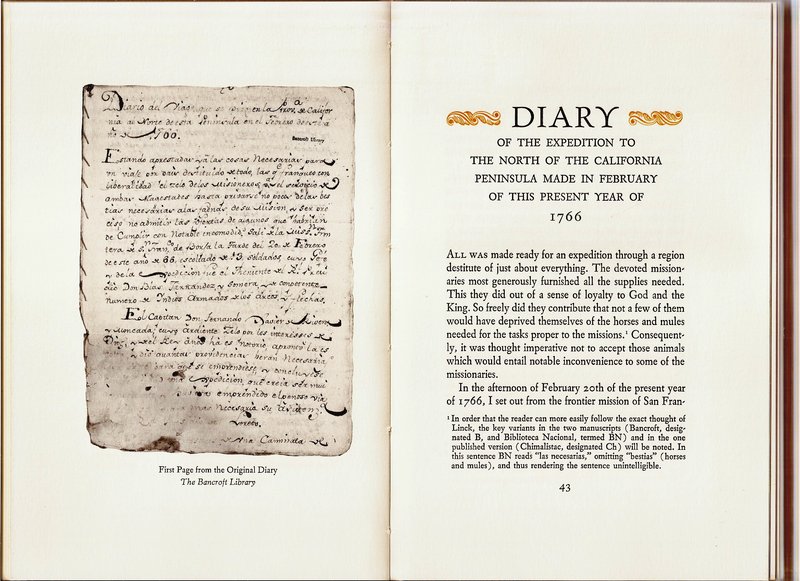
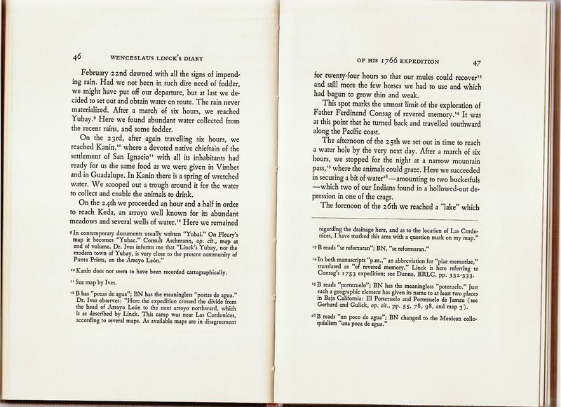
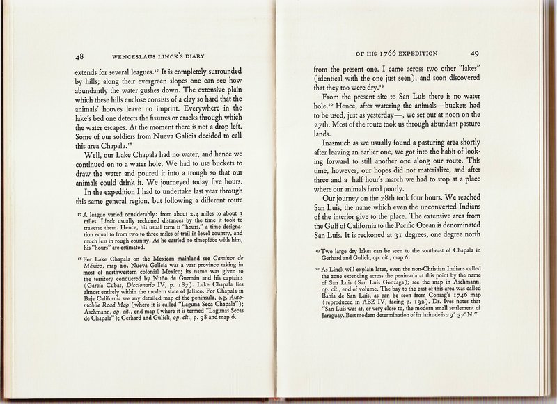
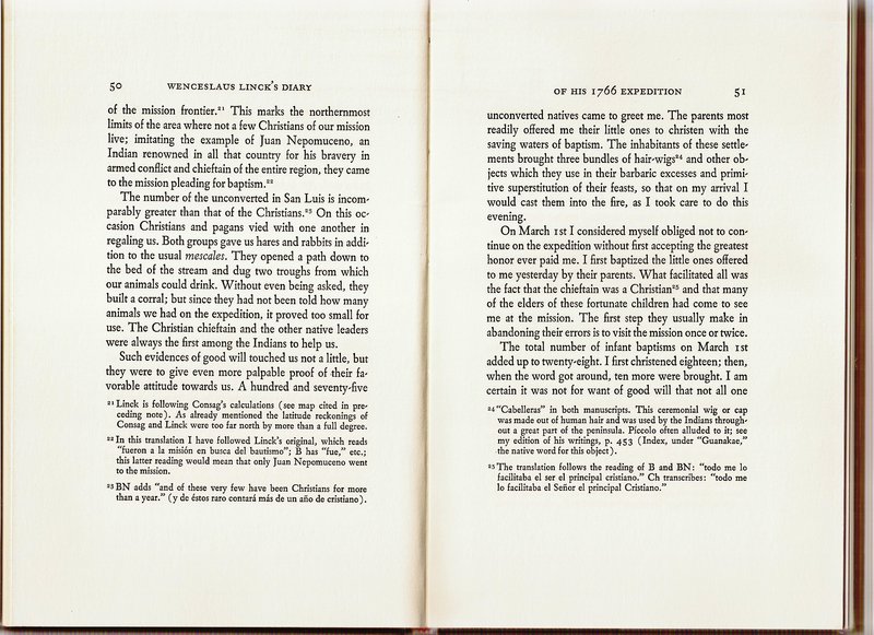
Linck's Diary of 1766 (and route map of the first days)

|
|
|
Lance S.
Nomad
Posts: 151
Registered: 2-16-2021
Member Is Offline
|
|
Thank you David. Guadalupe is mentioned on page 45, while at agua amarga, and 46 while at aqua leon. The text only seems to make sense if the
expedition passed through Guadalupe on the first day out from San Borja.
I believe the next page after you left off, page 52, is where Linck mentions arroyo San Jose.
|
|
|
David K
Honored Nomad
Posts: 64491
Registered: 8-30-2002
Location: San Diego County
Member Is Offline
Mood: Have Baja Fever
|
|
Ok, I had the above already scanned. I can scan more. You also may enjoy having this book, too. The Dawson Baja California Travels set is really a
gold mine for us history nerds.
|
|
|
Lance S.
Nomad
Posts: 151
Registered: 2-16-2021
Member Is Offline
|
|
Don't worry about posting it. I have a copy buried in a box somewhere in storage. I remember the gist of it. He suggested a Cabacera for San Luis
be established on arroyo San Jose, he said agriculture would not be possible but it could raise cattle. His description sounds like here 29°21'50"N
114°44'52"W.
Thats one possibility for the San Fernando settlement called San Joseph/ San Jose. Another possibility is is San Jose de las Palomas located here.
29°24'13"N 114°37'11"W. That one is marked Las Palomas on Goldbaum and seems to be called Codornices on modern maps.
[Edited on 12-5-2022 by Lance S.]
|
|
|
David K
Honored Nomad
Posts: 64491
Registered: 8-30-2002
Location: San Diego County
Member Is Offline
Mood: Have Baja Fever
|
|
Ok, amigo. Let me know if you need to see it later.
As for the other 'missions' beyond the true missions of Old California: A mission was an enterprise or project (not just a church), and many places
were called missions by the Padres. Unless the new project had an endowment to pay for it and a priest assigned to it, it was not a 'true' mission.
Loreto had two visitas that were called missions early on, San Juan Bautista de Londó and Nuestra Señora de los Dolores (not the same place as the
place to the south that became a mission).
The Jesuits established 17 missions. Confusion occurs because nearly half of them moved one or more times. Often the mission name, used in writings,
reflected the new location name rather than the official name. My book clears up this confusion.
|
|
|
Lance S.
Nomad
Posts: 151
Registered: 2-16-2021
Member Is Offline
|
|
Sorry to beat a dead horse but are San Juan de Dios and Las Llagas the same place?
"Juan de Dios de las Llagas Dos meses después de Crespí, varios días acampó fray Junípero Serra en San Juan de Dios. Se vio obligado a hacerlo
debido a que se le agravó una llaga que ya tenía desde varios años atrás y justo en el paraje se le hinchó y le impidió caminar. Fue en dicho
paraje donde el arriero de la expedición, quien con frecuencia le curaba las llagas a los caballos y mulas, le curó la llaga a Serra, quedando desde
entonces aliviado de la molestia. Muchos consideraron milagrosa esta curación, ya que ningún médico había logrado curarlo. Debido a esto, durante
mucho tiempo al paraje se le conoció como San Juan de Dios de las Llagas"
https://www.elvigia.net/el-valle/2012/5/20/juan-dios-81481.h...
EDÌT: Evidently not a true story. Just looked at the death records for San Fernando. San Juan de Dios and Las Llagas are indeed two different
places.
[Edited on 12-6-2022 by Lance S.]
|
|
|
| Pages:
1
2
3 |


