| Pages:
1
2
3
4 |
advrider
Super Nomad

Posts: 1847
Registered: 10-2-2015
Member Is Offline
|
|
I'll be in the area next week on my T700, would be better on the 500. If I get out that way and look around, I'll come back and post. Probably do a
ride report as well.
Any tracks would help. I have the old no wimps track.
[Edited on 2-25-2023 by advrider]
|
|
|
JZ
Elite Nomad
Posts: 9407
Registered: 10-3-2003
Member Is Offline
|
|
I was able to open it with Google Earth.
|
|
|
DizzyNick
Newbie
Posts: 24
Registered: 2-21-2023
Member Is Offline
|
|
The Google Earth screen shot posted by TMW on page 2 is the same route
If we were on our little bikes (300s) then we would attempt it without concern. But we are on 650s and 690s
|
|
|
4x4abc
Ultra Nomad
Posts: 4202
Registered: 4-24-2009
Location: La Paz, BCS
Member Is Offline
Mood: happy - always
|
|
try this in kmz:
Attachment: El Gato Out.kmz (2kB)
This file has been downloaded 92 times
Harald Pietschmann
|
|
|
4x4abc
Ultra Nomad
Posts: 4202
Registered: 4-24-2009
Location: La Paz, BCS
Member Is Offline
Mood: happy - always
|
|
Quote: Originally posted by David K  |
Mostly curious why you called it a Boleo tractor track.
This is on one of the El Camino Real routes between San Ignacio and Santa Gertrudis. In your photo, the trail is not level. Possibly from the fill
dirt all washed away. Wouldn't a dozer scrape to make a level road. The width looks more like the ECR width than an auto road...?
Thanks for answering my curiosity.
I wrote an article about the Cuestas of El Caminio Real, a few years back:
https://www.bajabound.com/bajaadventures/bajatravel/cuestas_...
In it, is this:
A cuesta culebreada (switchback grade) as Harry Crosby called it, is between Arroyo el Infierno and Santa Marta, located at 27⁰29.800’,
-112⁰55.830’ (2,600’). Cuesta de Tagualila at 27⁰49.777’, -113⁰01.300’ (1,840’) is where the Camino Real leaves the San Gregorio Plain
and Crosby noted that here the old road is very deeply built with loose rock as much as five feet high on each side. Near the bottom of this grade,
another branch of the Camino Real is seen as it climbs a short, steep grade. The cut trail is colored white compared to the dark volcanic surface
rock. The top of this “Cuesta Blanca” is the small lakebed, Laguna la Tahualina. Both branches come together again several
miles to the northwest.
[Edited on 2-24-2023 by David K] |
I call it a Boleo dozer track because that’s what it is. Created between 1910 and 1920.
You find them only between the roughly 50 Boleo Ranchos.
Camino Real is often nearby or the track is laid right onto it.
Boleo stopped operating around 1950 - so the tracks have not seen maintenance in 70 years.
Erosion on the grade sections has most likely destroyed formerly flat surfaces.
The width is always around 10 feet. ECR is usually between 4 and 5 feet.
Cuesta el Culebreado is not between Arroyo el Infierno and Santa Marta
it is between Rancho El Triunfo (a Boleo cattle ranch) and and Rancho Buenos Aires (another Boleo cattle ranch)
Cuesta el Culebreado is actually at 27⁰49.777’, -113⁰01.300’
but you can call any Cuesta "culebreado" (wriggly)
Cuesta de Tagualila is at 27° 49.098', -112° 58.026' - also called Cuesta Blanca, Cuesta del Tahualila, Cuesta la Tahualina

Harald Pietschmann
|
|
|
4x4abc
Ultra Nomad
Posts: 4202
Registered: 4-24-2009
Location: La Paz, BCS
Member Is Offline
Mood: happy - always
|
|
| Quote: Originally posted by advrider | I'll be in the area next week on my T700, would be better on the 500. If I get out that way and look around, I'll come back and post. Probably do a
ride report as well.
Any tracks would help. I have the old no wimps track.
[Edited on 2-25-2023 by advrider] |
I'
ll throw some track together for you
Harald Pietschmann
|
|
|
David K
Honored Nomad
Posts: 64558
Registered: 8-30-2002
Location: San Diego County
Member Is Offline
Mood: Have Baja Fever
|
|
Thank you, Harald.
|
|
|
4x4abc
Ultra Nomad
Posts: 4202
Registered: 4-24-2009
Location: La Paz, BCS
Member Is Offline
Mood: happy - always
|
|
here is Cuesta el Cuelebrado
the picture is at least 60 years old
so conditions will not have improved

Harald Pietschmann
|
|
|
JZ
Elite Nomad
Posts: 9407
Registered: 10-3-2003
Member Is Offline
|
|
I can't get this to load in GE. Is there a typo?
|
|
|
PaulW
Ultra Nomad
Posts: 3026
Registered: 5-21-2013
Member Is Offline
|
|
replace the degree symbol with a space
|
|
|
David K
Honored Nomad
Posts: 64558
Registered: 8-30-2002
Location: San Diego County
Member Is Offline
Mood: Have Baja Fever
|
|
It works fine on my map search... This is on the El Camino Real, where it crosses from the gulf side to the Pacific side of the mountains, south of
Santa Gertrudis (east from San Casimiro).
On the satellite image, there is new road constrution at the spot. Oddly, it has no beginning or a place it came from???
When I inserted the waypoint into Google, it did not work, either. On Google Earth, it didn't like the degree symbols used, as they look like a tiny 0
(does works with °, a true degree symbol, hold down Alt + type: 2 4 8).
|
|
|
JZ
Elite Nomad
Posts: 9407
Registered: 10-3-2003
Member Is Offline
|
|
Corrected the degree symbol.
Cuesta el Culebreado 27°49.777’, -113°01.300’
|
|
|
TMW
Select Nomad
Posts: 10659
Registered: 9-1-2003
Location: Bakersfield, CA
Member Is Offline
|
|
Here is a GE image similar to the first one I posted but with two tracks I followed north where they join at the 28th parallel then on to Santa
Gertrudis. I don't know if a bike or a 4x4 could get thru.
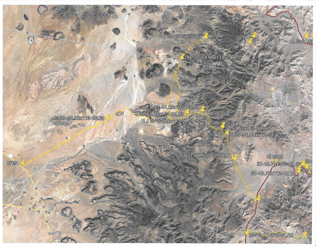
[Edited on 2-26-2023 by TMW]
|
|
|
4x4abc
Ultra Nomad
Posts: 4202
Registered: 4-24-2009
Location: La Paz, BCS
Member Is Offline
Mood: happy - always
|
|
I have hiked much of it
the Boleo tracks are nice an wide
about 80% of them are easily suitable for bikes
however, since they have not been maintained, Arroyo crossing are washed away and make it difficult to find a suitable path
and Cuestas so are badly eroded that it is even hard on foot to navigate them
since most Baja bikers are only looking for a fast rip through the bushes, I don't see it happening anytime soon that someone dedicates research and a
brutal ride to follow those "easy Google tracks"
I remember that we had a similar discussion some time ago about a possible moto trip between Santa Gertrudis and Visita San Juan de las Parras
we never heard back from that guy who was certain he could do it

Harald Pietschmann
|
|
|
DizzyNick
Newbie
Posts: 24
Registered: 2-21-2023
Member Is Offline
|
|
Pardon my ignorance, but what is a boleo? My Mexican history is carente
|
|
|
David K
Honored Nomad
Posts: 64558
Registered: 8-30-2002
Location: San Diego County
Member Is Offline
Mood: Have Baja Fever
|
|
Boleo is the name of the French mining company based in Santa Rosalia from the 1880s to 1954.
They built a network of roads to farms and cattle ranches in order to have a reliable food supply for the miners.
|
|
|
mtgoat666
Select Nomad
Posts: 17464
Registered: 9-16-2006
Location: San Diego
Member Is Offline
Mood: Hot n spicy
|
|
they should stick to riding established vehicle tracks. Pretty ugly when they rip up cattle trails or old abandoned routes and leave ugly scars on
the land.
Woke!
“...ask not what your country can do for you – ask what you can do for your country.” “My fellow citizens of the world: ask not what America
will do for you, but what together we can do for the freedom of man.”
Prefered gender pronoun: the royal we
|
|
|
4x4abc
Ultra Nomad
Posts: 4202
Registered: 4-24-2009
Location: La Paz, BCS
Member Is Offline
Mood: happy - always
|
|
| Quote: Originally posted by mtgoat666 |
they should stick to riding established vehicle tracks. Pretty ugly when they rip up cattle trails or old abandoned routes and leave ugly scars on
the land. |
now that is a funny one
how do you establish a track?
by riding/driving/bulldozing over dirt without a track
Harald Pietschmann
|
|
|
David K
Honored Nomad
Posts: 64558
Registered: 8-30-2002
Location: San Diego County
Member Is Offline
Mood: Have Baja Fever
|
|
| Quote: Originally posted by 4x4abc | | Quote: Originally posted by mtgoat666 |
they should stick to riding established vehicle tracks. Pretty ugly when they rip up cattle trails or old abandoned routes and leave ugly scars on
the land. |
now that is a funny one
how do you establish a track?
by riding/driving/bulldozing over dirt without a track |
Another point is that we are from this planet, and like the animals who make trails to get to places, humans do too. It is NOT an unnatural or alien
thing.

|
|
|
DizzyNick
Newbie
Posts: 24
Registered: 2-21-2023
Member Is Offline
|
|
| Quote: Originally posted by David K | | Quote: Originally posted by 4x4abc | | Quote: Originally posted by mtgoat666 |
they should stick to riding established vehicle tracks. Pretty ugly when they rip up cattle trails or old abandoned routes and leave ugly scars on
the land. |
now that is a funny one
how do you establish a track?
by riding/driving/bulldozing over dirt without a track |
Another point is that we are from this planet, and like the animals who make trails to get to places, humans do too. It is NOT an unnatural or alien
thing.
|
Well said David!
|
|
|
| Pages:
1
2
3
4 |


