BajaNomad

Gary Patton - Updated Jan. 5, 2015

 Pages:  1  ..  15    17    19  ..  24

EnsenadaDr - 4-14-2014 at 10:19 PM

How far is the area where the car was found from the coast? Doug mentioned the area was going to get very hot, in the 90s and 100s. It is closer to Catavina than Canoas from what I gathered. In any case, to be prepared is better than not.

micah202 - 4-14-2014 at 11:26 PM

Quote:
Originally posted by Hook
Another assumption by the good doc that is FALSE. Several of them in this thread already.


...REALLY??.....how can this be????:O:o:?:

EnsenadaDr - 4-14-2014 at 11:42 PM

Let's stop the pettiness guys. Again the family is reading. Bring your sweatshirts and your space heaters if it's too cold for you. I have never said I know it all or that I am perfect. It might just snow, so bring your snowshoes as well.

[Edited on 4-15-2014 by EnsenadaDr]

BajaNomad - 4-15-2014 at 12:29 AM

Quote:
Originally posted by EnsenadaDr
How far is the area where the car was found from the coast? Doug mentioned the area was going to get very hot, in the 90s and 100s.


Other than the rancher, nobody here knows for certain the actual pinpoint location where the vehicle was found. I proposed a point I felt matched the description, and others have suggested locations quite a distance away - some further inland.

As such, higher temperatures in May must be considered as a real possibility to contend with.

:biggrin:

Taco de Baja - 4-15-2014 at 08:14 AM

All the plots I’ve seen, put the vehicle about 2/3rds of the way out to the coast, this is an area that is really in transition between the cooler coast and the hot inland. It's generally right around 95-100 here in August and September, unless it's raining, also seen it 105 at that time. I would guess in May it would not be that hot; likely no more than 85-90 in the day and mid 50's at night. Kind of like El Centro temps.

I would recommend camping over staying in a hotel for the searchers; you have to remember this spot is probably 2 hours, maybe a bit less if you like to drive fast, from the Cataviña hotel - that's a 4 hour commute every day. If you want to get an early start before it gets too hot (if it does) you'll have to leave Cataviña in the dark which lengthens the commute as your headlights will not cut through the cloud of dust of the car in front of you and you'll have to drive slower.

BajaNomad - 4-15-2014 at 08:27 AM

According to this (and I am uncertain where this report is coming in from - and how valid it is)... last year in the first half of May - it was anywhere from 82-105 degrees:

http://www.accuweather.com/en/mx/catavina/1068472/month/1068...

BooJumMan - 4-15-2014 at 08:36 AM

Quote:
Originally posted by Taco de Baja
All the plots I’ve seen, put the vehicle about 2/3rds of the way out to the coast, this is an area that is really in transition between the cooler coast and the hot inland. It's generally right around 95-100 here in August and September, unless it's raining, also seen it 105 at that time. I would guess in May it would not be that hot; likely no more than 85-90 in the day and mid 50's at night. Kind of like El Centro temps.

I would recommend camping over staying in a hotel for the searchers; you have to remember this spot is probably 2 hours, maybe a bit less if you like to drive fast, from the Cataviña hotel - that's a 4 hour commute every day. If you want to get an early start before it gets too hot (if it does) you'll have to leave Cataviña in the dark which lengthens the commute as your headlights will not cut through the cloud of dust of the car in front of you and you'll have to drive slower.


Agreed!

I would even go out and say its more of a 3+hr drive (one way) to that location from Cataviña! Depending on road conditions of course, but its a haul no matter what.

willardguy - 4-15-2014 at 08:39 AM

Quote:
Originally posted by BajaNomad
According to this (and I am uncertain where this report is coming in from - and how valid it is)... last year in the first half of May - it was anywhere from 82-105 degrees:

http://www.accuweather.com/en/mx/catavina/1068472/month/1068...
so we can definitely say maybe cloudy with a chance of weather :rolleyes:

EnsenadaDr - 4-15-2014 at 08:48 AM

Maybe the Rancher might agree to let searchers stay at his ranch for a few days to avoid the long drive while looking over that area.

Hook - 4-15-2014 at 08:58 AM

Quote:
Originally posted by EnsenadaDr
Maybe the Rancher might agree to let searchers stay at his ranch for a few days to avoid the long drive while looking over that area.


Now, THAT is a good idea, as long as the search party is relatively self-contained.

If he could be relied on for a shaded area and possibly wash water, it could be a real plus.

It's not that hard to carry enough drinking water for several days in the vehicles but a rinse-off after a period of searching in the desert might allow for a morning search period and a late afternoon one.

And bring the Katadyns or the Pürs.

[Edited on 4-15-2014 by Hook]

Hook - 4-15-2014 at 09:02 AM

What sized rig could get down that road from Catavina to the coast? Could a full sized, 4wd truck with a full sized truck camper make it or is there too much sand in places?

EnsenadaDr - 4-15-2014 at 09:10 AM

I am trying to get the Rancher's number from Lizard Lips. I can go meet with him in Maneadero and talk with him about the idea or Lizard can call him. What I like about the idea is that we can all talk with him and glean all the information relevant to Gary and I think we will get a good feel where to go from there.
Quote:
Originally posted by Hook
Quote:
Originally posted by EnsenadaDr
Maybe the Rancher might agree to let searchers stay at his ranch for a few days to avoid the long drive while looking over that area.


Now, THAT is a good idea, as long as the search party is relatively self-contained.

If he could be relied on for a shaded area and possibly wash water, it could be a real plus.

It's not that hard to carry enough drinking water for several days in the vehicles but a rinse-off after a period of searching in the desert might allow for a morning search period and a late afternoon one.

And bring the Katadyns or the Pürs.

[Edited on 4-15-2014 by Hook]

BajaBlanca - 4-15-2014 at 09:12 AM

Wow, what a lot to bear in mind as the group prepares to go into the desert ... Is there a time frame for when this search will take place (sorry if it was written somewhere and I missed it).

EnsenadaDr - 4-15-2014 at 09:15 AM

Blanca how do you get from La Bocana to Catavina, and are you near Canoas?

Mexitron - 4-15-2014 at 09:16 AM

Quote:
Originally posted by Hook
What sized rig could get down that road from Catavina to the coast? Could a full sized, 4wd truck with a full sized truck camper make it or is there too much sand in places?


No problem, generally.

Taco de Baja - 4-15-2014 at 09:24 AM

Quote:
Originally posted by Hook
What sized rig could get down that road from Catavina to the coast? Could a full sized, 4wd truck with a full sized truck camper make it or is there too much sand in places?


Easy. Even 2X4 cars can make it as long as you stick to the roads, and carefully drive around the rocks and gullies; it's a fairly well graded and maintained road to the coast. BUT you still have to choose your path carefully in a low slung 2X4 car. There’s a couple of steep slippery hills and I would not take a car out there, but somehow the Mexicans do manage get cars out to the coast. A 4X4 will easily make it.

I did not recommend camping AT the rancher's place as that seems like we are imposing on him a little more than we should...but maybe near the ranch house. Put yourself in his position. Would you like/want a bunch of people camping in your front yard? In any event, respect the land, pack it in, pack it out.

motoged - 4-15-2014 at 09:59 AM

Quote:
Originally posted by EnsenadaDr
Blanca how do you get from La Bocana to Catavina, and are you near Canoas?


I have a hunch that a map will be forthcoming.

Doc, what maps do you use for scoping Baja?

BajaBlanca - 4-15-2014 at 10:03 AM

Doc - we are really far from Cataviña and I don't even know where Canoas is. I wish I could help but this is way out of my element. I am diabetic so not a good idea but besides that, I hate camping, I think I got camped out by doing it so much as a teenager in Brazil.

As long as everyone is well prepared with food and water, this seems like a great move. Esp if the rancher cooperates and with a little incentive for his trouble, I can't see why he wouldn't. And by incentive, it can be meat, clothes, the list is endless.

EnsenadaDr - 4-15-2014 at 10:20 AM

You guys are the experts with that area. I don't do much exploring in Baja, I wanted to get down to BOLA and Mulege, I spent most of my time in Ensenada. I am learning as I go along here. I am glad there are people that know the roads, the weather and the areas where the search is going to take place.
Quote:
Originally posted by motoged
Quote:
Originally posted by EnsenadaDr
Blanca how do you get from La Bocana to Catavina, and are you near Canoas?


I have a hunch that a map will be forthcoming.

Doc, what maps do you use for scoping Baja?

EnsenadaDr - 4-15-2014 at 10:23 AM

I'm interested in a detailed map from Canoas to Catavina and the roads that are available and the possible routes that Gary could have wanted to take off of highway 1 and where his car was relative to those roads.

Hook - 4-15-2014 at 10:24 AM

Quote:
Originally posted by EnsenadaDr
I am trying to get the Rancher's number from Lizard Lips. I can go meet with him in Maneadero and talk with him about the idea or Lizard can call him. What I like about the idea is that we can all talk with him and glean all the information relevant to Gary and I think we will get a good feel where to go from there.


LL is the de facto spokesman for the family and Nomads, at this point. Best if there is only one of those, IMO. HE should do the corresponding, if he is willing. And if the family is willing.

Centralized information would seem to be an advantage, IMO. Less chance for miscommunications and cross purposes.


[Edited on 4-15-2014 by Hook]

durrelllrobert - 4-15-2014 at 10:24 AM

Quote:
Originally posted by EnsenadaDr
Blanca how do you get from La Bocana to Catavina, and are you near Canoas?

Don't know about Blanca but here's how I'd do it:
1. La Bocana east to Santo Tomas on the worst road I've ever been on = 17 miles or 1 hour.
2.Santo Tomas to Catavina = 207 miles or 4 hours

vgabndo - 4-15-2014 at 10:39 AM

Quote:
Originally posted by EnsenadaDr
Blanca how do you get from La Bocana to Catavina, and are you near Canoas?


Seriously Doc? SERIOUSLY!!! Do you not own a MAP of Baja? Have you EVER been south of that big flag in Ensenada????

Why, exactly, do you need to ask this question?

As it stands now, there won't be any need to arrange for "air conditioned rooms" and a 6 hour daily commute, as far as I know, none of the people who have volunteered to help have been contacted by the Patton family in any way. I only know, through u2u, of a couple of people with any interest in going bone hunting, and certainly there is NO urgency to learn what the vehicle and cameras might have to tell anyone. The family seems to think they have it under control and certainly there is no hurry to learn more. (Waiting until May to check the cameras?) A while back, the family suggested that people aught to be looking for a guy with nine months growth of hair and beard! To me this demonstrates a significant disconnect with the most likely reality.

DENNIS - 4-15-2014 at 10:45 AM

Quote:
Originally posted by vgabndo
To me this demonstrates a significant disconnect with the most likely reality.


Is "faith" a byproduct of religion, or is it human nature?
Just curious.

vgabndo - 4-15-2014 at 10:47 AM

Quote:
Originally posted by EnsenadaDr
I'm interested in a detailed map from Canoas to Catavina and the roads that are available and the possible routes that Gary could have wanted to take off of highway 1 and where his car was relative to those roads.


READ THE THREAD!!!!! LOOK AT ALL THE DAMNED MAPS!!!!! Use the search function. Open Google Earth and go to the exact coordinates of the best guess for the car's location. Please don't start pointing-out little dark spots on Google Earth and telling the rest of us where "you are sure" we should start looking. I obviously can't handle your first 150 posts to this thread. :lol:

EnsenadaDr - 4-15-2014 at 10:51 AM

There are roads, but how passable are they. From what some mentioned, Gary was most likely headed to Canoas but took the long way around. What road was he on vs. the route he should have been on?
Quote:
Originally posted by vgabndo
Quote:
Originally posted by EnsenadaDr
I'm interested in a detailed map from Canoas to Catavina and the roads that are available and the possible routes that Gary could have wanted to take off of highway 1 and where his car was relative to those roads.


READ THE THREAD!!!!! LOOK AT ALL THE DAMNED MAPS!!!!! Use the search function. Open Google Earth and go to the exact coordinates of the best guess for the car's location. Please don't start pointing-out little dark spots on Google Earth and telling the rest of us where "you are sure" we should start looking. I obviously can't handle your first 150 posts to this thread. :lol:

EnsenadaDr - 4-15-2014 at 10:53 AM

I realize now that La Bocana is way south of Canoas but a few of the maps I looked up on Google had another La Bocana much closer to the coordinates of the car.
Quote:
Originally posted by durrelllrobert
Quote:
Originally posted by EnsenadaDr
Blanca how do you get from La Bocana to Catavina, and are you near Canoas?

Don't know about Blanca but here's how I'd do it:
1. La Bocana east to Santo Tomas on the worst road I've ever been on = 17 miles or 1 hour.
2.Santo Tomas to Catavina = 207 miles or 4 hours

vgabndo - 4-15-2014 at 11:01 AM

Quote:
Originally posted by DENNIS
Quote:
Originally posted by vgabndo
To me this demonstrates a significant disconnect with the most likely reality.


Is "faith" a byproduct of religion, or is it human nature?
Just curious.


Since the vast majority of humans have historically "believed" a lot of stuff on false or insufficient evidence, I'd answer: human nature. In my judgement, "religion" is used to bolster the insufficient evidence for things like "hell" and "everlasting life", or the righteous killing of infidels. While it muddles the thinking of some folks, I doubt it will have much effect on a search unless the family determines to spend time on one of the palm readers you suggested.

absinvestor - 4-15-2014 at 11:06 AM

I agree with Hook- one person (LL) for communication with the rancher. Also, Ensenada Dr commented on an earlier post that we should stop the pettiness etc and reminded us that the family reads these posts. I concur-the petty bickering and cheap shots do nothing to help figure out what happened to Gary. As the saying goes we can disagree without being disagreeable. I can vision a real mess when the search begins. Seems we have friction among some of the posters. If that friction is evident once the search begins the search will be miserable for everybody and especially the family. (Ever been at a family reunion where a couple of unhappy members ruins the outing for everybody??) In order to limit the trampling of clues the search must be organized. If the search has 25 chiefs and a couple Indians it will not go well. Even though LL is not experienced in a searching operation he is experienced in basically everything else and he has shown an incredible desire and ability to listen to others and just as importantly to recognize when we are getting off base and/or doing things that can be hurtful to the family. I don't personally know many of the other posters. If the chief organizer is not LL I believe it should be someone who not only knows how to organize a search but has the ability to see that egos don't get in the way of a successful search.

EnsenadaDr - 4-15-2014 at 11:10 AM

There is a guy I recommended to Lizard. His name is Ralph Shoemaker. He runs the RV park at Santa Ines a few miles south of Catavina. I read he knows the area like the back of his hand, obviously he is a Gringo with that name. I did send an email to Hotel La Mision in Catavina and got a response from a worker there who said he see if he could contact Ralph. Obviously LL is aware of this and he and the family makes all the final decisions.

DENNIS - 4-15-2014 at 11:30 AM

Quote:
Originally posted by vgabndo
I doubt it will have much effect on a search unless the family determines to spend time on one of the palm readers you suggested.


And, don't forget the Ouija Board as a font of knowledge. This is a direct link to Spiritualpedia.com.
Here it is again....just in case you missed it:

http://www.brainjar.com/dhtml/ouija/

DENNIS - 4-15-2014 at 11:36 AM

Quote:
Originally posted by EnsenadaDr
I realize now that La Bocana is way south of Canoas but a few of the maps I looked up on Google had another La Bocana much closer to the coordinates of the car.


There is La Bocana, 20 miles [+-] toward the beach from Todos Santos.

dtbushpilot - 4-15-2014 at 11:51 AM

Quote:
Originally posted by absinvestor
I agree with Hook- one person (LL) for communication with the rancher. Also, Ensenada Dr commented on an earlier post that we should stop the pettiness etc and reminded us that the family reads these posts. I concur-the petty bickering and cheap shots do nothing to help figure out what happened to Gary. As the saying goes we can disagree without being disagreeable. I can vision a real mess when the search begins. Seems we have friction among some of the posters. If that friction is evident once the search begins the search will be miserable for everybody and especially the family. (Ever been at a family reunion where a couple of unhappy members ruins the outing for everybody??) In order to limit the trampling of clues the search must be organized. If the search has 25 chiefs and a couple Indians it will not go well. Even though LL is not experienced in a searching operation he is experienced in basically everything else and he has shown an incredible desire and ability to listen to others and just as importantly to recognize when we are getting off base and/or doing things that can be hurtful to the family. I don't personally know many of the other posters. If the chief organizer is not LL I believe it should be someone who not only knows how to organize a search but has the ability to see that egos don't get in the way of a successful search.


I doubt that it will be an issue, once a time and place are decided upon to begin the search most of the "Indiana Jones wannabe's" will realize that they have conflicting schedules. The Nomads that do show up will be those who should.

lizard lips - 4-15-2014 at 12:04 PM

The rancher is at his ranch right now and will be there for two weeks. I DON"T want the rancher contacted by anyone other than the family or myself as I don't want him to be bombarded with people he has never met and asked another series of questions. I know there are a lot of unanswered questions we need to ask him but they can wait for awhile.

The rancher told me he doesn't mind people camping at his property but they had better bring everything needed. He also told me that it takes him two hours once leaving the highway to get to his ranch and he drives very slow.

The ball is in the families court, so to speak, in that they are coming down to get the 4 Runner and go to the area where it was found. I don't have any dates yet and I also don't know what their thinking is regarding having a search attempted with the Nomads at the same time. If it were me-----I would want those involved to come and assist but because I have never spoken with Gary's two sons and his brother Dave we will just have to wait and see. I may not be able to make it anytime soon because of my work load. I have three business trips planned and must be done prior to the first week of May but that could change also so I don't want ya all to give me any grief if I'm not there on-site.

EnsenadaDr - 4-15-2014 at 12:04 PM

here was the original map that appeared near the search site between La Bocana and Catavina. I know that Todos Santos is way down near Cabo and so I wouldn't be referring to that one Dennis.

https://www.google.com/maps/dir/Catavi%C3%B1a,+Mexico/La+Boc...

Mexitron - 4-15-2014 at 12:35 PM

Doc---I think you're referring to Rancho la Bocana, which is northwest of Catavina. and fairly close, as the crow flies, to the truck site. It sits in the upper drainage of the arroyo system that empties into Punta Canoas.

Mexitron - 4-15-2014 at 12:37 PM

Quote:
Originally posted by EnsenadaDr
Blanca how do you get from La Bocana to Catavina, and are you near Canoas?


Blanca lives in La Bocana, down by Abreojos and Bahia Asuncion---long ways away from Rancho la Bocana.

DENNIS - 4-15-2014 at 12:40 PM

Quote:
Originally posted by EnsenadaDr
I know that Todos Santos is way down near Cabo and so I wouldn't be referring to that one Dennis.


https://www.google.com/maps/dir/Catavi%C3%B1a,+Mexico/La+Boc...


Different TS. I'm referring to TS, around twenty miles south of Maneadero.

Here's a fix for your link:

http://tinyurl.com/kufp5dg

absinvestor - 4-15-2014 at 12:43 PM

DTbushpilot-You're probably correct- let's hope

Jaybo - 4-15-2014 at 01:38 PM

OK, I just had a thought here (and I'm not caught up by any means (4/11/14 11:46am is the post I am on right now) but Garys truck looked like it had pretty big tires on it and was a 2WD - What would the speedo/odometer correction be for those tires? 2WD's had pretty smallish tires as stock IIRC. Don't know if it even matters but it just popped into my head ...

Back to reading...

pappy - 4-15-2014 at 01:44 PM

what is the possibilty of bringing in an ultra lite type airplane/glider for a look see from the sky above?

David K - 4-15-2014 at 01:58 PM

Quote:
Originally posted by EnsenadaDr
There is a guy I recommended to Lizard. His name is Ralph Shoemaker. He runs the RV park at Santa Ines a few miles south of Catavina. I read he knows the area like the back of his hand, obviously he is a Gringo with that name. I did send an email to Hotel La Mision in Catavina and got a response from a worker there who said he see if he could contact Ralph. Obviously LL is aware of this and he and the family makes all the final decisions.


Ralph doesn't run an RV park! He is a retired guy who lives part time near Rancho Santa Ynez. He communicates on a HAM radio and has assisted people having problems getting to Mission Santa Maria. The camp area at Rancho Santa Ynez has no hook ups and has been managed by Oscar and Matilda at Santa Ynez (last I knew). The RV park is in Cataviña, just north of the Hotel Mision Cataviña.

On another post... TS and ST have been mixed up! Please don't abbreviate to just two letters... The town about 30 miles south of Ensenada is SANTO TOMAS (ST) not Todos Santos (TS). There is a 'LA BOCANA' on the coast west from Santo Tomas.

There are MANY places called LA BOCANA in Baja. Usually a river mouth or canyon mouth... sometimes a lagoon mouth.

There is an archaeological site (perhaps a ranch there too) called La Bocana, 3 miles off the road to Faro San Jose/ Puerto Canoas, about 8 miles from Hwy. 1.

Do we need maps posted AGAIN? :wow:

woody with a view - 4-15-2014 at 02:03 PM

:no:

DENNIS - 4-15-2014 at 02:17 PM

Quote:
Originally posted by David K

On another post... TS and ST have been mixed up! Please don't abbreviate to just two letters... The town about 30 miles south of Ensenada is SANTO TOMAS (ST) not Todos Santos (TS). There is a 'LA BOCANA' on the coast west from Santo Tomas.


Thanks, David. That would be my mistake.
Ohhh well........some days are better than others.

EnsenadaDr - 4-15-2014 at 02:19 PM

That's the one Mexitron. Dennis, I wouldn't pick an area near Ensenada or even near San Quintin. I know generally where the truck is somewhere between Canoas and Catavina off of Highway 1. I am trying to picture where Gary would have turned off to go to Canoas if he left San Quintin that morning, would it have been easier for him to take another route or is this route way off of where he would have turned? That's why a road map of all those small roads off Highway 1 would be helpful, which ones were driveable in his vehicle and which ones weren't.
Quote:
Originally posted by Mexitron
Doc---I think you're referring to Rancho la Bocana, which is northwest of Catavina. and fairly close, as the crow flies, to the truck site. It sits in the upper drainage of the arroyo system that empties into Punta Canoas.
Quote:

EnsenadaDr - 4-15-2014 at 02:35 PM

you might also ask him what areas the Rancher has looked in, if indeed he did scope the area for Gary initially when he found the car.and maybe some theories or ideas he has about the disappearance.
Quote:
Originally posted by lizard lips
The rancher is at his ranch right now and will be there for two weeks. I DON"T want the rancher contacted by anyone other than the family or myself as I don't want him to be bombarded with people he has never met and asked another series of questions. I know there are a lot of unanswered questions we need to ask him but they can wait for awhile.

The rancher told me he doesn't mind people camping at his property but they had better bring everything needed. He also told me that it takes him two hours once leaving the highway to get to his ranch and he drives very slow.

The ball is in the families court, so to speak, in that they are coming down to get the 4 Runner and go to the area where it was found. I don't have any dates yet and I also don't know what their thinking is regarding having a search attempted with the Nomads at the same time. If it were me-----I would want those involved to come and assist but because I have never spoken with Gary's two sons and his brother Dave we will just have to wait and see. I may not be able to make it anytime soon because of my work load. I have three business trips planned and must be done prior to the first week of May but that could change also so I don't want ya all to give me any grief if I'm not there on-site.

David K - 4-15-2014 at 03:07 PM

Quote:
Originally posted by EnsenadaDr
That's the one Mexitron. Dennis, I wouldn't pick an area near Ensenada or even near San Quintin. I know generally where the truck is somewhere between Canoas and Catavina off of Highway 1. I am trying to picture where Gary would have turned off to go to Canoas if he left San Quintin that morning, would it have been easier for him to take another route or is this route way off of where he would have turned? That's why a road map of all those small roads off Highway 1 would be helpful, which ones were driveable in his vehicle and which ones weren't.

Quote:
Originally posted by Mexitron
Doc---I think you're referring to Rancho la Bocana, which is northwest of Catavina. and fairly close, as the crow flies, to the truck site. It sits in the upper drainage of the arroyo system that empties into Punta Canoas.


EnsenadaDr:

You really need to take a drive south to get a feel for what lies along the 1,000+ mile Hwy. 1.

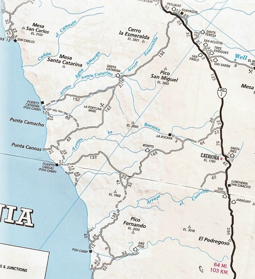
This area (El Rosario to Guerrero Negro is all desert... along the Pacific is is cool and foggy much of the time. Gary's truck was found approx. 10 miles from the Pacific and 30 miles from Hwy. 1 (at a point 6 miles north of Cataviña).

There are not many 2WD graded dirt roads... But after El Rosario, there is the road to Punta San Carlos. The road to Puerto Catarina. Then the road to Faro San Jose and Canoas.

There is a connection from the Catarina road to Canoas, but it has some silt and may not have been the choice for 2WD.

The Faro San Jose road is perhaps the best 2WD road to Canoas. However, NONE of that matters does it? The place to search is from his 4Runner out.


The 'Fish Camp' on the lower left of the map is San Jose (Faro San Jose is the lighthouse there)... There is also a Rancho San Jose up the arroyo from the fish camp (on the map).

Per the posted directions given by Lizard Lips, the 4Runner was found near where the thin blue longitude line crosses the road to Puerto Canoas (with the mileage 13.9 along side it).

willardguy - 4-15-2014 at 03:17 PM

just out of curiosity......has anyone been able to spot the ranch in question on GE?

Mexitron - 4-15-2014 at 05:23 PM

I haven't seen more than a couple wide spots in the road and what looks like cowboy camps in the area of the truck. There are more ranches on the main road to San Jose however so its probably on of those.

EnsenadaDr - 4-15-2014 at 05:35 PM

Thanks David, I am getting the layout in my mind. It matters because the route he took does not seem one that would have been logical to get to Punta Canoas and since he was not an avid fisherman I doubt he was headed to the fish camp. It all just doesn't fit in because the main road that goes through Santa Catarina would have been much more direct. Why did Gary take the road closer to Catavina to turn off the main highway instead? Or he could have meandered over to Puerto Canoas from Punta Canoas where it seems there is some type of connection there,

mtgoat666 - 4-15-2014 at 05:42 PM

Quote:
Originally posted by EnsenadaDr
It all just doesn't fit in because the main road that goes through Santa Catarina would have been much more direct. Why did Gary take the road closer to Catavina to turn off the main highway instead?


perhaps he thought like this...


TWO roads diverged in a yellow wood,
And sorry I could not travel both
And be one traveler, long I stood
And looked down one as far as I could
To where it bent in the undergrowth;

Then took the other, as just as fair,
And having perhaps the better claim,
Because it was grassy and wanted wear;
Though as for that the passing there
Had worn them really about the same,

And both that morning equally lay
In leaves no step had trodden black.
Oh, I kept the first for another day!
Yet knowing how way leads on to way,
I doubted if I should ever come back.

I shall be telling this with a sigh
Somewhere ages and ages hence:
Two roads diverged in a wood, and I—
I took the one less traveled by,
And that has made all the difference.

latina - 4-15-2014 at 05:57 PM

You forgot to quote your source mtgoat 666.

Mexitron...I can't reread 84 pages....are you the person who quoted being on that road after Gary disappeared from his family?

Wasn't the road as far as the fork to Las Canoas the track for the Baja Mil in November?

Mexitron - 4-15-2014 at 06:01 PM

latina---I've been out in that area a lot of the years but my friend Taco de Baja was the one out there last summer as the monsoon rains came in.

DENNIS - 4-15-2014 at 06:04 PM

Quote:
Originally posted by latina
You forgot to quote your source mtgoat 666.


I'll do it for him: "Robert Frost"

wilderone - 4-15-2014 at 07:07 PM

"... since he was not an avid fisherman I doubt he was headed to the fish camp."
Doesn't matter if he wasn't planning on fishing. Getting to a "fish camp" means: (1) there's a road to it, i.e., access to the ocean/gulf; (2) there would be a beach topography for launching a boat (or surfing or fishing or camping) - accessible oceanfront. He may have decided to go to the fish camp to surf. The weather was poor, very likely had rained in that area between Sept. 5 and Sept. 9th. So did he try and then not make it all the way - stopped short instead of driving in mud, or it was getting dark? Or did he get to the coast and was leaving because of bad weather? Or did he take one of the many little spur roads and get lost? And started to hike back to the coast for assistance after he got stuck? Not necessarily on the road? Do we believe the rancher that the car was not there in December?

danaeb - 4-15-2014 at 08:03 PM

Quote:
Originally posted by woody with a view
:no:


:(:(:(

Taco de Baja - 4-15-2014 at 08:47 PM

Quote:
Originally posted by latina


Mexitron...I can't reread 84 pages....are you the person who quoted being on that road after Gary disappeared from his family?


I was out there the week before , August 25th, it was raining the first of several storms. I believe it was TW who was out there the week of, or week after Gary was supposed to be there I was only on the road between San Jose and Catavina, and not the road to Canoas.

bajadogs - 4-15-2014 at 09:16 PM

Quote:
Originally posted by willardguy
just out of curiosity......has anyone been able to spot the ranch in question on GE?


I am very curious too, but I imagine the rancher would not want the whole cyber-nomad world zooming in on his humble ranch.

I would be very curious to see how easily or difficultly the rancher leads people to the spot. It could be very telling as to wether he may have missed spotting the SUV in December. Of course the fact he went back to tow it out may blow my theory.

David K - 4-15-2014 at 11:08 PM

Quote:
Originally posted by EnsenadaDr
Thanks David, I am getting the layout in my mind. It matters because the route he took does not seem one that would have been logical to get to Punta Canoas and since he was not an avid fisherman I doubt he was headed to the fish camp. It all just doesn't fit in because the main road that goes through Santa Catarina would have been much more direct. Why did Gary take the road closer to Catavina to turn off the main highway instead? Or he could have meandered over to Puerto Canoas from Punta Canoas where it seems there is some type of connection there,


I thought I mentioned why he would not have likely used the Santa Catarina road to get to Canoas?: He does NOT have 4WD.

Not that 4WD is needed on the crossover road from Santa Catarina, but if he got advice, then the Faro San Jose road to Canoas may had been recommended...? It is all graded and no moon dust pits... (as I had experienced on the north road into Canoas).

That he drove over a mile on a single track, off the graded road, then 400 meters up a wash to get stuck at, is weird.

bajadogs - 4-15-2014 at 11:49 PM

Quote:
Originally posted by David K
That he drove over a mile on a single track, off the graded road, then 400 meters up a wash to get stuck at, is weird.


Maybe weird, maybe just a mistake. How many times have you come across and rescued someone who drove a 2wd where they needed 4x4?

Plenty for me.

Mexitron - 4-16-2014 at 05:20 AM

Quote:
Originally posted by bajadogs
Quote:
Originally posted by David K
That he drove over a mile on a single track, off the graded road, then 400 meters up a wash to get stuck at, is weird.


Maybe weird, maybe just a mistake. How many times have you come across and rescued someone who drove a 2wd where they needed 4x4?

Plenty for me.


If there were existing tracks going up the arroyo then the misstep idea makes more sense...but I don't see any road on google earth in that arroyo so it must have been a pretty faint road.

Mexitron - 4-16-2014 at 05:43 AM

This case is giving me a headache.


EnsenadaDr - 4-16-2014 at 07:04 AM

Question remains, where is Gary?

DENNIS - 4-16-2014 at 07:16 AM

Quote:
Originally posted by bajadogs

Maybe weird, maybe just a mistake. How many times have you come across and rescued someone who drove a 2wd where they needed 4x4?


You mean, like out in the surf? :o

CaboMagic - 4-16-2014 at 09:54 AM

Dear Patton Family,
We have nothing significant to add to the sleuthing discussions.
We wish simply to continue to extend our support to you with best wishes and prayers.
T&L

absinvestor - 4-17-2014 at 08:39 AM

CaboMagic- well said. Our sentiments exactly.

SoCalPattonCrew - 4-17-2014 at 02:39 PM

Dearest Nomads, the family has had several rough days here so trying to reach today. We just do not have any more updates as yet, but I can offer some clarifications on things previously mentioned:
- The camera had one photo of the trucker accident monument, somewhere along Hwy 1 south after El Rosario (?), and it was dated September 5th, 2013. Two other pics taken that same day were nondescript horizons. Because our guys (my son and his uncle) could not search through the vehicle when they were there, any chance of a photo card in the truck is still TBD; and, these date stamps will be verified again as well;
- The family (brothers) cannot travel down there again until May 1st so we are relying on the newspaper El Mexicana, Baja Times, Ecos to help publicize that we are still looking for him; and of course bajanomads here as well;
- At someone's suggestion about the Baja 1000, I had tried back then but tried again last week to request from SCORE that they reach out to any videographers filming during that race, to check their footage, if they were by chance near the arroyo car sighting; no replies to-date;
- There has not been any activity on the bank account etc. ; alerts are in place from 09/13 if activity occurs;
- Regarding the rancher, he is no longer in Meandera and probably is headed toward the ranch if not there now;
- Gary's brother-in-law double-checked the brand of tires to calculate mileage differential and says the difference is negligible but we thank you for questioning it;
Sincerest thanks to all of you, trying to stay focused on where Gary may be in relation to the vehicle, especially if /where he could be held up with some caring folk. Special thanks to DavidK's road maps (page 47); for those offering GoogleEarth (see multiples on pg. 48), and, DavidK's recent one this week ... we should keep in mind to take copies of these excellent maps when a team begins a search.
To those wanting to get searching now, our prayers are with you, but we certainly do not feel comfortable making such a request. I admit I am curious as to someone's mention of a "fisherman" who "has a cell phone" that sometimes works, whether he has seen Gary at any time as well as other resident ranchers and locals in those remote surf & fish sites.
For now, we are just painfully waiting and trying very hard to keep faith ... we appreciate the focused discussion on recent posts as to how to go about SAFETY in conducting a search in such desolate areas, particularly how all will be able to communicate efficiently with each other, and track each other at a all times, while they do this search.
Our deepest gratitude for all the time & effort each of you have taken to care about finding our Gary.....

Mexitron - 4-17-2014 at 02:55 PM

Patton's----the fisherman with the cell phone lives in the Faro San Jose fish camp. That was some years ago since I last talked with him. But you or someone should go there and talk with the locals if you have the chance. I should be out there in August on my way to another location along the coast but would be happy to stop and talk with them if nothing has been resolved by then, though I certainly hope for the best and am sorry you all have to go through this.

woody with a view - 4-17-2014 at 03:52 PM

at the San Jose camp up on the hill bout a mile before the beach on the north side look for a cabover camper next to a house. Ask for Sra Mercedes, Isreal or his wife Erika. They are the top of the food chain as far as the ejido/co-op goes in that area. they will have any tidbits to offer, if any exist.

tell them Roberto y Beatriz sent ya. they are really good people.

David K - 4-17-2014 at 03:53 PM

If there were no fish in the ice chest or wax on the surf board, he may have been headed out to the coast rather than away from it when the truck was stuck.

I still am not sure that matters which direction he was headed, since the truck was found midway between the highway and the coast. The place to search for Gary is out from the truck, as there is 0 evidence of any crime (from what I read).

If there is new or different directions to where the truck was found, I am happy to show the area on maps or satellite images from Google or Bing.

Skipjack Joe - 4-18-2014 at 10:46 AM

Quote:
Originally posted by SoCalPattonCrew

- The camera had one photo of the trucker accident monument, somewhere along Hwy 1 south after El Rosario (?), and it was dated September 5th, 2013. Two other pics taken that same day were nondescript horizons. Because our guys (my son and his uncle) could not search through the vehicle when they were there, any chance of a photo card in the truck is still TBD; and, these date stamps will be verified again as well;


Why would Gary remove a new memory card from his camera and insert an old one?

We can be reasonably certain that Gary did not take more pictures after the 9/5 date frame.

That means:

(1) No time spent in Canoa surfing
(2) No 4 months spent in baja after 9/5

Gary probably never even reached the coast.

Hook - 4-18-2014 at 11:20 AM

Patton family: do you have a TENTATIVE itinerary as to how you are going to proceed on this May 1st trip? Will you commence a search? What type of assistance will you be bringing down, in terms of persons, especially an interpretor(s)? It sounds like LL will not be with you, correct?

Or, is this all information that you prefer to keep private? Or do you prefer to do this on your own?

I ask because IF you are interesting in having assistance from Nomad members and IF there are members that are interested, it's time both parties begin trying to coordinate their time schedules, at the very least.

Hook - 4-18-2014 at 11:24 AM

Quote:
Originally posted by Skipjack Joe
Quote:
Originally posted by SoCalPattonCrew

- The camera had one photo of the trucker accident monument, somewhere along Hwy 1 south after El Rosario (?), and it was dated September 5th, 2013. Two other pics taken that same day were nondescript horizons. Because our guys (my son and his uncle) could not search through the vehicle when they were there, any chance of a photo card in the truck is still TBD; and, these date stamps will be verified again as well;


Why would Gary remove a new memory card from his camera and insert an old one?

We can be reasonably certain that Gary did not take more pictures after the 9/5 date frame.

That means:

(1) No time spent in Canoa surfing
(2) No 4 months spent in baja after 9/5

Gary probably never even reached the coast.


Yep. I'd say he never made it. He got a late start leaving SQ and was headed up that wash for an overnighter (since he wasnt going to make the coast in daylight) and got stuck and then ?????? I think the rancher is mistaken about the truck not being there a week before he discovered it.

Or, there's something more nefarious going on, here..........

EnsenadaDr - 4-18-2014 at 12:27 PM

I know the family is discounting the photos as not very informative, but first of all we know one thing. He got as far as that monument? Does anyone know the location of the monument? It was past El Rosario, but was it past the turnoff road that led to Gary's truck? Two were the pictures of the horizon in early morning or late evening? He left at 6 am from the hotel so if the pictures were afternoon or late evening, that means he went somewhere before that turnoff, or maybe he made it to canoas and was on his way back..I think there could be a lot of information gleaned from those pictures.

absinvestor - 4-18-2014 at 01:09 PM

SkipjackJoe-agreed. Hook- makes no sense that he would have headed up to where the truck was found to camp. Too far off the beaten track.

DENNIS - 4-18-2014 at 01:17 PM

Quote:
Originally posted by absinvestor
SkipjackJoe-agreed. Hook- makes no sense that he would have headed up to where the truck was found to camp. Too far off the beaten track.


Could confusion have been a factor? I'm not suggesting anything clinical.......just normal confusion.

wiltonh - 4-18-2014 at 01:24 PM

There is some new technology which might help the communication issues faced while doing a search. It is called Mesh Networking and it allows cell phones to communicate with each other without having a cell network.

The first application that I know about is Firechat and it allows text messages to be sent where no Wifi or Cell network is available. It currently runs under IOS7 on an iPhone 5.

Here is an article about the technology:

http://www.cultofmac.com/271225/appreciated-ios-7-feature-wi...

So far I have not found a distance listed so who knows how useful it really would be. It is new enough that I thought it was worth a post.

David K - 4-18-2014 at 01:35 PM

Quote:
Originally posted by EnsenadaDr
I know the family is discounting the photos as not very informative, but first of all we know one thing. He got as far as that monument? Does anyone know the location of the monument? It was past El Rosario, but was it past the turnoff road that led to Gary's truck?


Between Kms 116 and 117 (37 miles south from El Rosario's Pemex station).

No, it is well before the turnoff to Faro San Jose/ Puerto Canoas and also before the turnoff to Santa Catarina/ Puerto Canoas.

Taco de Baja - 4-18-2014 at 01:45 PM

Quote:
Originally posted by EnsenadaDr
I know the family is discounting the photos as not very informative, but first of all we know one thing. He got as far as that monument? Does anyone know the location of the monument? It was past El Rosario, but was it past the turnoff road that led to Gary's truck? Two were the pictures of the horizon in early morning or late evening? He left at 6 am from the hotel so if the pictures were afternoon or late evening, that means he went somewhere before that turnoff, or maybe he made it to canoas and was on his way back..I think there could be a lot of information gleaned from those pictures.


It's likely the "Hector" monument. It's well known to those travelling south of El Rosario. It’s more elaborate than most roadside memorials.

Don’t know the coordinates but it's between KM 116 and 117, so it's around 51 KM (32 miles) from the Faro San Jose turn-off. A time stamp on that will give a good timeline if it's one of the last photos.

Please stop saying he left the hotel at 6am, we do not know that for sure. You are creating unneeded confusion with you time assumptions.


BajaNomad - 4-18-2014 at 02:03 PM

Quote:
Originally posted by Hook

He got a late start leaving SQ...


LL confirmed a 6am departure on 9/5 from Jardines.


Quote:
Originally posted by Hook
...and was headed up that wash for an overnighter (since he wasnt going to make the coast in daylight)...


This still seems to be the simplest explanation to me. A question I have with this is:

Did he just sleep in the truck (or intend to sleep in the truck)? The tent was in the truck but not setup. He either never used it, or had packed it away already.


Quote:
Originally posted by Hook

...I think the rancher is mistaken about the truck not being there a week before he discovered it.


From everything I've read:
- The rancher said the truck wasn't there in December.
- The rancher said he believed the truck had been in the location he found it for no more than a week.

David K - 4-18-2014 at 02:18 PM

The rancher also may want to be not 'blamed' for not seeing the 4Runner (not a truck) for several months... not that it's his responsibility for that. If it was 400 meters up a side wash from the auto track, close to 2 kms. from the graded road, it may have never been spotted. Lucky that it was. Why he took the effort to pull it out is weird. I still would like to know where his ranch was in relation to the 4Runner.

BajaNomad - 4-18-2014 at 02:19 PM

Quote:
Originally posted by David K


Between Kms 116 and 117 (37 miles south from El Rosario's Pemex station).


Right here:

http://goo.gl/maps/VeQ8d

BajaNomad - 4-18-2014 at 02:28 PM

Quote:
Originally posted by absinvestor
Hook- makes no sense that he would have headed up to where the truck was found to camp. Too far off the beaten track.


I would disagree. As this is a very common practice, and is one of the most likely reasons put forth thus far to explain the vehicle location as we understand it.

Hook - 4-18-2014 at 02:32 PM

Well, at least this sets to rest the idea that he never even left San Quintin, right?

Justbozo - 4-18-2014 at 02:41 PM

Hook

Yes it does.

As I also stated the pictures will tell a story.
The landscape pics, if taken after the memorial shot, may provide further tracking.

Gary being with the 4 Runner when it got stuck still doesn't add up, based on the ranchers timeline.

Hook - 4-18-2014 at 02:56 PM

Quote:
Originally posted by absinvestor
SkipjackJoe-agreed. Hook- makes no sense that he would have headed up to where the truck was found to camp. Too far off the beaten track.


Well, then I make no sense when I am camping, 'cause I do that a lot.

I dont want to camp by the side of a main thoroughfare that everyone must come through on their way to the main destination in the area; the ocean. I like privacy. Maybe he does, too.

[Edited on 4-18-2014 by Hook]

EnsenadaDr - 4-18-2014 at 03:12 PM

Well when he stopped off to take that picture, depending if the landscape pictures come before or after, that is where he could have met his fate.

Hook - 4-18-2014 at 03:21 PM

Quote:
Originally posted by EnsenadaDr
Well when he stopped off to take that picture, depending if the landscape pictures come before or after, that is where he could have met his fate.


Yeah, and that also COULD have been where he took a crap.

Coulda, woulda, shoulda...........your speculations are either irrelevant or so far off-base as to cloud the discussion.

I dont care if you feel I'm being petty. You're becoming an impediment to the discussion, Doctor. THINK things through before you post and post from a position of knowledge. You have made false assumptions on geography, on the motivations of fishermen, on the motivations of surfers and the motivations of camping..........and I'm left feeling you know nothing about any of those.

Sometimes less is more...............

willyAirstream - 4-18-2014 at 03:23 PM

At the beginning of this thread, it was mentioned he had cameras, plural. If there is another camera, it may provide more location clues

EnsenadaDr - 4-18-2014 at 03:37 PM

Remember George Michaels? Assaults often happen in rest stops off of highways. You are an impediment Hook by saying things that aren't true like Gary got a late start in SQ. You don't have YOUR facts straight. Yet I don't jump down your throat for screwing up the information. Let's realize no one knows where Gary is, and until they have the solution to his disappearance, I don't think they can afford to criticize the ideas of others. Someone else accused me of saying that I was making up the hour of departure from San Quintin, yet LL clearly said it was 6 am. So before you start throwing stones at me, you guys get YOUR facts straight. Just sayin'.

tripledigitken - 4-18-2014 at 04:16 PM

He had two cameras and only one was viewed.

Additional cards COULD have been used in second camera.

( I don't think Gary had been camping for 6 months after leaving SQ Sept 5th)

FWIW


Quote:
Originally posted by Skipjack Joe
Quote:
Originally posted by SoCalPattonCrew

- The camera had one photo of the trucker accident monument, somewhere along Hwy 1 south after El Rosario (?), and it was dated September 5th, 2013. Two other pics taken that same day were nondescript horizons. Because our guys (my son and his uncle) could not search through the vehicle when they were there, any chance of a photo card in the truck is still TBD; and, these date stamps will be verified again as well;


Why would Gary remove a new memory card from his camera and insert an old one?

We can be reasonably certain that Gary did not take more pictures after the 9/5 date frame.

That means:

(1) No time spent in Canoa surfing
(2) No 4 months spent in baja after 9/5

Gary probably never even reached the coast.


[Edited on 4-18-2014 by tripledigitken]

tripledigitken - 4-18-2014 at 04:20 PM

There is more conjecture than facts in this thread.


Quote:
Originally posted by EnsenadaDr
Remember George Michaels? Assaults often happen in rest stops off of highways. You are an impediment Hook by saying things that aren't true like Gary got a late start in SQ. You don't have YOUR facts straight. Yet I don't jump down your throat for screwing up the information. Let's realize no one knows where Gary is, and until they have the solution to his disappearance, I don't think they can afford to criticize the ideas of others. Someone else accused me of saying that I was making up the hour of departure from San Quintin, yet LL clearly said it was 6 am. So before you start throwing stones at me, you guys get YOUR facts straight. Just sayin'.


[Edited on 4-18-2014 by tripledigitken]

EnsenadaDr - 4-18-2014 at 04:27 PM

Another idea would be to stop at that monument and look around.

chuckie - 4-18-2014 at 04:29 PM

Geez Doc......give it up.....

EnsenadaDr - 4-18-2014 at 04:45 PM

I happen to think it's a good idea. Hey another good idea, especially on this Easter weekend is to stop ridiculing and belittling someone for coming up with ideas. I don't get sarcastic when someone has an idea and belittle them. Peace on Earth good will to mankind, hey remember guys, Gary is either seriously hurt or he's not with us anymore. Appreciate the fact that you are alive and respect your fellow man or woman. At least on this Good Friday/Passover weekend, let's cool it with the cheap shots. Yes, Chuckie give it up, Brother.

[Edited on 4-18-2014 by EnsenadaDr]

DENNIS - 4-18-2014 at 05:07 PM

Jeeezo........someone fire up the Nomad Hookah. :biggrin:

EnsenadaDr - 4-18-2014 at 05:15 PM

Hey Dennis, you have a great Easter with you and yours. I don't like Hookah the smoke bothers me. But i might be coerced into a Pina colada!!

absinvestor - 4-18-2014 at 10:13 PM

I believe some Nomads knew Gary from prior trips. Personally if I was camping alone I would prefer to be in a less remote spot than where the Truck was found-Hook and others, on the other hand, would prefer to camp more remotely.( I was guessing that because Gary liked to talk and visit with others and not a loner type he would be more likely to camp where others might be.) Do any Nomads that knew him from prior trips have any thoughts as to what type of camping Gary enjoyed? Also, we can hope that there are other pictures on the second camera-many people use different cameras for different type pictures.

Mexitron - 4-19-2014 at 10:21 AM

From what I've read Gary didn't seem the type to drive a 2WD truck up a remote canyon with apparently no road up it. That's what I would do, but I have 4WD and like exploring.

Skipjack Joe - 4-19-2014 at 11:08 AM

During my baja travels I always drive off any road for the night. Far enough so that the lights from neither my campfire nor the camper can be seen from the. I do have a 4WD now but did it with a 2WD previously by picking dirt roads judiciously.

The 2km road which I think I'm seeing in GE is pretty distinct. The side turn after that looks 'sketchy' (today's vernacular). I always figured that Gary just misjudged the softness of the sediment. That can happen to anyone. The best camping spots in such areas are the washes. You have clean sand, nearby rocks, and deadwood for campfire. Plus you are protected visually because they are often a bit lower (erosion).

Given the report drug activity in the area it's not surprising that he didn't camp right off that main road but was more cautious. Most of us would do that.

Again it's really hard to make really solid conclusions without seeing the place.

 Pages:  1  ..  15    17    19  ..  24