BajaNomad

NB/SB Hwy 1 (toll road) Closed at La Mision due to road collapse (pictures)

 Pages:  1  2  

BajaNomad - 12-29-2013 at 11:02 PM

btw everyone, Ken's pic above ^^^^^^^^^^^^^^^^^^ (or at least prior to this one depending on how your pages are spaced)...

...is a prank. :biggrin:


http://www.sandiegored.com/noticias/43809/Twitter-users-are-...


[Edited on 12-30-2013 by BajaNomad]

BajaNomad - 12-29-2013 at 11:21 PM

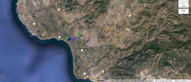
I was directed back to an El Vigia article I skimmed yesterday, and saw there was an idea proposed to build a detour from Salsipuedes across to the free road - that the travel on the free road would then be only 10km, instead of 45km (and the gov't could collect more in toll fees of course).

If you look at the map from above, it's not that far. The elevation gain is another question. The person that proposed this idea said something like 30 or 45 days to put it into place.

:rolleyes:

detour-potential.jpg - 49kB

BajaNomad - 12-29-2013 at 11:26 PM

Looking a little further north...

detour-potential-2.jpg - 49kB

BajaNomad - 12-29-2013 at 11:34 PM

I think that road and structure in the middle there is part of the Cuatro Cuatros facility, no?

http://cabanascuatrocuatros.com.mx/en/location.php


elgatoloco - 12-29-2013 at 11:44 PM

http://geology.campus.ad.csulb.edu/people/bperry/Mass%20Wast...

Road should have never been built IMHO. It was 'scenic' while it lasted.

Salsipuedes - get out while you can.

I would love to see the interview with the driver of the semi truck. Me thinks he has story to tell the grandkids. :wow:

El Mirador was built without proper paperwork.

Whale-ista - 12-30-2013 at 12:43 AM

Quote:
Originally posted by elgatoloco
http://geology.campus.ad.csulb.edu/people/bperry/Mass%20Wast...

Road should have never been built IMHO. It was 'scenic' while it lasted.

Salsipuedes - get out while you can.

I would love to see the interview with the driver of the semi truck. Me thinks he has story to tell the grandkids. :wow:

El Mirador was built without proper paperwork.


Paperwork? We don't need no stinkin' paperwork! :lol:

I drove past that place nearly every week from 1992-2000, occasionally at night, and never understood when or if it would be open for Business. I had nightmares about that curve and the steep descent to the now departed stretch of road far below. Narrow, dark and little room for error or second chances.

That stretch of highway has Such a great view, yet so little planning...


[Edited on 12-30-2013 by Whale-ista]

BajaNomad - 12-30-2013 at 02:29 AM

Quote:
Originally posted by elgatoloco
I would love to see the interview with the driver of the semi truck.


“Un vadito como de 10 centímetros, pero ya a la hora de subir a este lado, ya estaba como de 60 centímetros, entonces, había unos troques más atrás de nosotros, venían vacíos, ellos se pudieron echar para atrás, yo ya no pude”, manifestó el conductor del camión, Gabriel González.

http://www.uniradioinforma.com/noticias/bajacalifornia/artic...

He's interviewed in this news clip posted earlier in the thread:


gabriel-truck-driver.jpg - 39kB

dasubergeek - 12-30-2013 at 07:52 AM

I updated the map with the proposed alternative. It goes from the dirt road east of the Bajamar bridge inland and connects with an existing dirt road that comes out at the turnoff for Greater Metropolitan Santa Rosa, about half a mile north of the turnoff for El Tigre. It's a great idea; there's not much road to be built, and the rest could be paved (or not, oh Mexico). If they did pave it, it'd be a great permanent route in to the Valle.

bajadock - 12-30-2013 at 09:17 AM

Dasubergreek,
Thanks for your map. Did you site a source in an earlier post/thread? The east end of the proposed alternative detour on your map paves through Rancho Las Chichihuas, located near the top of the last hill climbing south on Free Road.

https://www.facebook.com/RanchoLasChichihuas

At least part of the paving is done, as Las Chichihuas looks like they have a nice tennis court. :tumble:

Bajanomad, you are correct on your Cuatro Cuatros location. Their property(according to my last tour their in Nov 2013) extends all the way from Free Road to Toll Road.


My drive yesterday(Sunday) from La Mision to toll booth/Hwy1 detour was 45 minutes in moderate traffic. That trip usually takes me 35 minutes, but a motorcycle ride of approx 12 riders with police escort bogged it down a tad. Lots of new pavement on Free Road makes it ez.


Only quirk was the rerouting U turn at the end southbound. I was directed on a 200m jog north toward the toll booth, then U turn south. Either they are working on that bridge or the tiendas and restaurants(San Miguel and Boules) paid someone to create the detour toward their businesses.


[Edited on 12-30-2013 by bajadock]

Udo - 12-30-2013 at 09:52 AM

The Portugese bend is in South Los Angeles area, about 2 miles west of the Trump golf course, Palos Verdes Peninsula. Thre were six houses in the area that slid down about 300' towards the ocean.


Quote:
Originally posted by BajaBlanca
What's the Portuguese bend?

Scary pics those. Mighty scary.

Point A to Point B

durrelllrobert - 12-30-2013 at 10:01 AM

Quote:
Originally posted by BajaNomad
I was directed back to an El Vigia article I skimmed yesterday, and saw there was an idea proposed to build a detour from Salsipuedes across to the free road - that the travel on the free road would then be only 10km, instead of 45km (and the gov't could collect more in toll fees of course).

If you look at the map from above, it's not that far. The elevation gain is another question. The person that proposed this idea said something like 30 or 45 days to put it into place.

:rolleyes:


Ken Cooke - 12-30-2013 at 05:22 PM


David K - 12-30-2013 at 05:41 PM

That's good Ken, even before the recent slide, you can see the bulge into the Pacific where it has been dropping the past 10 years. See if you can bring up a new satellite image of the same spot.

Bajahowodd - 12-30-2013 at 05:59 PM

Geez. We are into whale season. In addition to the inveterate that drive the trip on their own, there are a bunch of tour companies that take folks down from the US. The whales might be lonely this year.

David K - 12-30-2013 at 06:02 PM

Hwy. 1-D isn't the only road to Ensenada (or points south). If anyone wants to go to Baja, they won't let a detour or a different highway affect them, will they?

Traveling soon.

fixtrauma - 12-30-2013 at 07:24 PM

Well.......that was our planned route the end of January as we head again to La Paz. I will be watching this thread closely for alternate updates. I have appreciated the pictures and information so far.

micah202 - 12-30-2013 at 08:06 PM

.

...the best 'planned route' for Baja is -whatever's open this time-!!


...put another way'''if yer wanna make the devil laugh--just make plans''':lol::lol::lol:

Spanish-language humor

Ken Cooke - 12-30-2013 at 09:20 PM


bajarich - 12-30-2013 at 09:35 PM

We'll be crossing at SY in about 2 weeks. I'm looking forward to driving the Libre detour, although I'll miss that pretty view from the Cuota. What's a Baja trip without a little adventure and a chance to see something new? It sure beats waiting for a week at my cousin's house in South Pasadena for the detours to be built after the bridges are washed out at El Rosario and Vicente Guerrero like few years ago, or duct taping the doors and being pulled through the flooding aroyos with a bulldozer.

BornFisher - 12-30-2013 at 09:45 PM

Quote:
Originally posted by bajarich
We'll be crossing at SY in about 2 weeks. I'm looking forward to driving the Libre detour, although I'll miss that pretty view from the Cuota. What's a Baja trip without a little adventure and a chance to see something new? It sure beats waiting for a week at my cousin's house in South Pasadena for the detours to be built after the bridges are washed out at El Rosario and Vicente Guerrero like few years ago, or duct taping the doors and being pulled through the flooding aroyos with a bulldozer.


But it might take you an extra 15 minutes!!!
Seriously, it is a beautiful drive. I remember about 5 years ago in March, all streams were flowing, all dams full and even some ranches cut off by all the water. Green as could be, I enjoyed every minute!! And BTW--- my choice to take that road, just to take that road!!

durrelllrobert - 12-31-2013 at 11:04 AM

Quote:
Originally posted by David K
Hwy. 1-D isn't the only road to Ensenada (or points south). If anyone wants to go to Baja, they won't let a detour or a different highway affect them, will they?


We've had 6 months of detours from Maneadero to La Bufadora but the busses keep bring the tourists from the cruise ships out just to see the blow hole.

EnsenadaDr - 12-31-2013 at 08:49 PM

Bob have they done any repair work that you have heard of that might take a week to fix the road?:o

News report points out 50 years of neglecting road, infrastructure upkeep (Spanish)

Whale-ista - 12-31-2013 at 10:36 PM

Proposal to connect truck route from Bajamar to eastern free road (similar to what someone posted earlier):
Mario Zepeda puntualizó en la necesidad de encontrar una solución permanente para esta vialidad, y que una opción viable a corto plazo sería la propuesta planteada por el Colegio de Ingenieros Civiles de Ensenada.
Recordó que consiste en conectar la autopista con el puerto en el kilómetro 77+500 -en el puente de Bajamar-, donde adecuando el camino de terracería se propone conectar la Escénica con la carretera libre Tecate-Ensenada.
"A partir de esta situación salen a relucir las ineficiencias y la falta de atención a la infraestructura de Baja California, y en particular de Ensenada, ya que nos damos cuenta de que la carretera libre Ensenada-Tijuana no ha sido atendida y sigue en las mismas condiciones que hace 50 años”, lamentó.

from: http://www.elvigia.net/general/2013/12/31/aumentan-tiempos-c...

Bajahowodd - 1-1-2014 at 05:51 PM

Quote:
Originally posted by David K
Hwy. 1-D isn't the only road to Ensenada (or points south). If anyone wants to go to Baja, they won't let a detour or a different highway affect them, will they?


Just suggesting that funneling all the traffic that travels the toll road, including the tour outfits is going to result in VERY slow going along the old two lane highway.

bajaguy - 1-1-2014 at 09:26 PM

Other than the truck wreck yesterday, Ensenada people are reporting an extra 15-30 minutes added to their trip by taking the detour.


Quote:
Originally posted by Bajahowodd
Quote:
Originally posted by David K
Hwy. 1-D isn't the only road to Ensenada (or points south). If anyone wants to go to Baja, they won't let a detour or a different highway affect them, will they?


Just suggesting that funneling all the traffic that travels the toll road, including the tour outfits is going to result in VERY slow going along the old two lane highway.

David K - 1-1-2014 at 11:40 PM

All that whale watching traffic you think is on the roads still funnels down to a 2 lane, south of Ensenada... This detour only funnels it a little sooner, so yes you have Ensenada only traffic along with the rest of the peninsula traffic. However, as I said... there is still another highway to Ensenada, that so many here like to use southbound: Hwy. 3 from Tecate!

Just saying... :rolleyes::biggrin:

Best route south..?

Jdub - 1-2-2014 at 12:21 AM

Can any1 report that the free road is still a go @ La Mission or should we go Tecate Hwy 3 down?..thnx.

David K - 1-2-2014 at 12:44 AM

The only road closed is the toll road (1-D) south of La Mision to San Miguel Village.

The free roads (1 & 3) are both open to San Miguel Village & Ensenada.

EnsenadaDr - 1-2-2014 at 08:18 AM

still waiting to hear if the federales are allowing anyone that wants to go to La Salina or Bajamar on the toll road since there is no other way to get there.
Quote:
Originally posted by David K
The only road closed is the toll road (1-D) south of La Mision to San Miguel Village.

The free roads (1 & 3) are both open to San Miguel Village & Ensenada.

access allowed

bajaguy - 1-2-2014 at 08:22 AM

Yes, they are. If you can show proof of residence such as an INSEN card, CFE bill, phone bill, Mex DL......


Quote:
Originally posted by EnsenadaDr
still waiting to hear if the federales are allowing anyone that wants to go to La Salina or Bajamar on the toll road since there is no other way to get there.
Quote:
Originally posted by David K
The only road closed is the toll road (1-D) south of La Mision to San Miguel Village.

The free roads (1 & 3) are both open to San Miguel Village & Ensenada.

EnsenadaDr - 1-2-2014 at 08:41 AM

So you can't go to La Salina or Bajamar restaurants or Bajamar golf facility? So the tourism at those two places right now is pretty much shot...how sad
Quote:
Originally posted by bajaguy
Yes, they are. If you can show proof of residence such as an INSEN card, CFE bill, phone bill, Mex DL......


Quote:
Originally posted by EnsenadaDr
still waiting to hear if the federales are allowing anyone that wants to go to La Salina or Bajamar on the toll road since there is no other way to get there.
Quote:
Originally posted by David K
The only road closed is the toll road (1-D) south of La Mision to San Miguel Village.

The free roads (1 & 3) are both open to San Miguel Village & Ensenada.
:wow:

GBuff10 - 1-2-2014 at 11:42 AM

Went down south to San Quintin on Sunday, December 29 and came back up yesterday, January 1. We entered/exited at San Ysidro. Going south, you get detoured off at the La Fonda exit, and you take the Free Road (very clear on where to go), going through La Mision. You will pop back onto the Toll Road just south of the last toll booth near Ensenada (you actually enter back onto the Toll Road facing North, so they have you do a lefthand U-Turn to continue your drive South). It's all very clear. No confusion or hesitation at all on where the detour is. As others have reported, it only adds about 15-20 minutes to your drive. Easy and scenic. Enjoy!

durrelllrobert - 1-2-2014 at 01:31 PM

Quote:
Originally posted by David K
The only road closed is the toll road (1-D) south of La Mision to San Miguel Village.

The free roads (1 & 3) are both open to San Miguel Village & Ensenada.


On Tuesday, December 31, 2013 at 5:26 PM someone posted on the PBBB that a couple was heading NORTH on the free road from Ensenada and when they reached La Mission the police were turning everyone around, back towards Ensenada, because "a truck had overturned and was blocking both lanes". I don't understand how that could impact proceeding ahead on the free road and/or getting on to the toll road, but that's what they said????

BajaNomad - 1-2-2014 at 01:50 PM

Quote:
Originally posted by durrelllrobert
Quote:
Originally posted by David K
The only road closed is the toll road (1-D) south of La Mision to San Miguel Village.

The free roads (1 & 3) are both open to San Miguel Village & Ensenada.


On Tuesday, December 31, 2013 at 5:26 PM someone posted on the PBBB that a couple was heading NORTH on the free road from Ensenada and when they reached La Mission the police were turning everyone around, back towards Ensenada, because "a truck had overturned and was blocking both lanes". I don't understand how that could impact proceeding ahead on the free road and/or getting on to the toll road, but that's what they said????


Separate thread on that incident (from the same source) here:

http://forums.bajanomad.com/viewthread.php?tid=71309

David K - 1-2-2014 at 03:00 PM

An accident anywhere can happen anytime... A semi going too fast and flipping on a Baja highway... is that unusual? No, but very inconvenient since the toll road is washed out and the free road is the detour. In this case, the only alternative is Hwy. 3 to Tecate (the only way we go north from Ensenada, anyway... unless we are craving a Chef Johnny meal at the Half-Way House)!

rts551 - 1-2-2014 at 04:28 PM

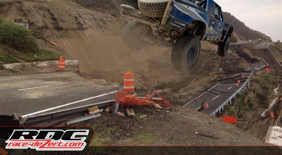
Race Dezert: "The road to Ensenada is fixed."


[img][/img]

David K - 1-2-2014 at 04:30 PM

:lol::lol::lol: piece of cake!

Bajamar

dpwahoo - 1-2-2014 at 04:37 PM

Quote:
Originally posted by GBuff10
Went down south to San Quintin on Sunday, December 29 and came back up yesterday, January 1. We entered/exited at San Ysidro. Going south, you get detoured off at the La Fonda exit, and you take the Free Road (very clear on where to go), going through La Mision. You will pop back onto the Toll Road just south of the last toll booth near Ensenada (you actually enter back onto the Toll Road facing North, so they have you do a lefthand U-Turn to continue your drive South). It's all very clear. No confusion or hesitation at all on where the detour is. As others have reported, it only adds about 15-20 minutes to your drive. Easy and scenic. Enjoy!
Yes, Dr., I have went golfing twice this week at Bajamar. I live in La Mision, and show them nothing, as I have nothing. Just tell them Im going to golf at Bajamar. It is my understanding that the bar restaurant at La Salina is closed for the winter.:O

wessongroup - 1-2-2014 at 05:07 PM

551 ... had the same thought ... need a new road ... just let the "folks" with that equipment have a month or so, and there will be a "road" of some sort

Perhaps like a few recall from the early days ... before good roads were present

Sometimes you made your own ... had too

EnsenadaDr - 1-2-2014 at 05:25 PM

Thanks so much for this valuable information.
Quote:
Originally posted by dpwahoo
Quote:
Originally posted by GBuff10
Went down south to San Quintin on Sunday, December 29 and came back up yesterday, January 1. We entered/exited at San Ysidro. Going south, you get detoured off at the La Fonda exit, and you take the Free Road (very clear on where to go), going through La Mision. You will pop back onto the Toll Road just south of the last toll booth near Ensenada (you actually enter back onto the Toll Road facing North, so they have you do a lefthand U-Turn to continue your drive South). It's all very clear. No confusion or hesitation at all on where the detour is. As others have reported, it only adds about 15-20 minutes to your drive. Easy and scenic. Enjoy!
Yes, Dr., I have went golfing twice this week at Bajamar. I live in La Mision, and show them nothing, as I have nothing. Just tell them Im going to golf at Bajamar. It is my understanding that the bar restaurant at La Salina is closed for the winter.:O

marek - 1-2-2014 at 09:49 PM

Drove north today on the free road. Slow moving traffic coupled with a semi that rolled off the free road. 2.5 hour wait at the border. With the road construction south of Ensenada also slowing things down, I'd probably enter through Tecate and head south from San Felipe on my next trip down. We left Shipwrecks at 9:30 am. Stopped for 30 minutes at El Trailero and didn't get across the border until 5pm.

Bob H - 1-2-2014 at 10:43 PM

Quote:
Originally posted by rts551
Race Dezert: "The road to Ensenada is fixed."


[img][/img]


Whoooo Hooooo !!!! :lol::lol::lol:

Ken Cooke - 1-3-2014 at 01:35 PM


Ateo - 1-3-2014 at 05:21 PM

I drove the free road yesterday and it went pretty quick. No biggie. The clerk at La Fonda said 1 year closure. I doubt that.

durrelllrobert - 1-3-2014 at 05:47 PM

Quote:
Originally posted by Ateo
I drove the free road yesterday and it went pretty quick. No biggie. The clerk at La Fonda said 1 year closure. I doubt that.

At least La Fonda and other places along the free road aren't losing business. How about the losses they are seeing at Baja Mar and La Salina. One year without tourists and others that don't physically live there could result in bankruptcy

Ateo - 1-3-2014 at 05:49 PM

Right you are.

And the Salsipuedes leasing office can pretty much be dismantled. =)


Quote:
Originally posted by durrelllrobert
Quote:
Originally posted by Ateo
I drove the free road yesterday and it went pretty quick. No biggie. The clerk at La Fonda said 1 year closure. I doubt that.

At least La Fonda and other places along the free road aren't losing business. How about the losses they are seeing at Baja Mar and La Salina. One year without tourists and others that don't physically live there could result in bankruptcy

Bajahowodd - 1-3-2014 at 05:54 PM

Quote:
Originally posted by David K
All that whale watching traffic you think is on the roads still funnels down to a 2 lane, south of Ensenada... This detour only funnels it a little sooner, so yes you have Ensenada only traffic along with the rest of the peninsula traffic. However, as I said... there is still another highway to Ensenada, that so many here like to use southbound: Hwy. 3 from Tecate!

Just saying... :rolleyes::biggrin:


Except that there is a major difference. There is a huge amount of both commercial and tourist traffic headed just to Ensenada. Much less traffic South of Ensenada.

David K - 1-3-2014 at 05:58 PM

Yes, very true... and why I had this part in my reply: "so yes you have Ensenada only traffic along with the rest of the peninsula traffic"

Have a GREAT new year HowOdd!

liknbaja127 - 1-3-2014 at 06:21 PM

Just, got back this afternoon, After a week. This was my first time on free road,
Very nice out there. only took 15,20 extra, mins get to Otay Mesa crossing.
Only 30 min. wait.

Bob H - 1-4-2014 at 12:43 AM

Quote:
Originally posted by liknbaja127
Just, got back this afternoon, After a week. This was my first time on free road,
Very nice out there. only took 15,20 extra, mins get to Otay Mesa crossing.
Only 30 min. wait.


NICE! :bounce:

Bajahowodd - 1-4-2014 at 05:51 PM

I think it's going to much like border crossing delays. It will depend on the day of the week and the time of the day.

Paulina - 1-4-2014 at 08:19 PM

We drove the Tecate road this morning. At 5am in the dark, we saw flashing lights coming our way. Had to pull to the side of the road to let two very large, very wide semis pass. Each one had a precast concrete GIANT I beam, heading south.

There was more big rig traffic on the road than we usually see.

(Crossed at 6:15. Took 2 min.)

P>*)))>{

Free road from San Miguel Ensenada

bajachris - 1-5-2014 at 08:25 AM

Yesterday I drove the free road which starts just before the San Miguel toll booth. It's a dirt road for about 1-2 miles. Then it appears they have been doing some major road construction. All new pavement most of the way. Lots of Federal police and absolutely no passing allowed. After hitting the road we drove along a narrow road with a sheer sandy drop of about 200+ feet, no guard rails and it looks like the road may collapse with the first big rain storm. Then later closer to the La Fonda valley is the sheer cliffs. Saw remnants of a truck off to one side. Reminds one of driving to Santa Rosalia. The trucks have to slow down so as not to hit the sides of the cliff. Seems like we have substituted one dangerous road for another. Can't they make safer roads?! This can't possible be a permanent solution.

Troubled Baja Road Could Open by Summer

Gypsy Jan - 1-5-2014 at 01:23 PM

From the San Diego Union Tribune:
http://www.utsandiego.com/news/2014/Jan/04/tp-troubled-baja-...

By Chris Nichols

"By summer, Mexican officials hope to reopen a troubled but popular toll road that funnels tourists to Baja California’s burgeoning wine country, an official with the state government said this week.

A portion of the Tijuana-to-Ensenada Scenic Road south of Rosarito Beach collapsed toward the sea in late December. Segments of pavement slid hundreds of feet down the steep sandstone cliffs upon which the corridor was built in the 1960s. No injuries were reported.

The closure of that stretch of toll road — the busiest highway in Baja California — comes amid the region’s fledgling tourism recovery. Business and government leaders said they’re publicizing alternate routes, and are hoping to have a temporary fix completed within half a year.

Still, the scale of the infrastructure damage has officials contemplating a long-term solution that could include diverting the road away from the treacherous Salsipuedes stretch of highway about 10 miles north of Ensenada, where the collapse took place, said Mariano Escobedo, director of international relations for the state government.

Before it closed, the toll road between Rosarito Beach and Ensenada handled an average of 8,000 vehicle trips per day, Escobedo said.

No details about repair plans or cost estimates were available this week, he said. Without ascribing blame, Escobedo also said the highway is owned and maintained by Mexico’s federal government.

“Natural causes” led to the collapse, he said, noting that a 4.6-magnitude earthquake on Dec. 19 south of Ensenada was likely a big contributor. He promised that repairs would start “as soon as possible,” though he couldn’t say whether sections of the road were still sinking.

Some are skeptical that an adequate fix, even a short-term one, can be made in six months. Others doubt the road can ever be safely reopened.

“Very frankly, that road should never have been built,” said Pat Abbott, a geology professor at San Diego State University who has studied the area in question.

Abbott said the decision to build along the fragile cliffs doomed the roadway. The seismic activity in that region doesn’t help, he said, but it wasn’t the main factor in the road’s deterioration.

"Gravity was", he said.

Decades of repairs

Problems with the Salsipuedes stretch have long been known.

Crews have repaired the highway for 25 to 30 years because of frequent landslides, said Hugo Torres, owner of the iconic Rosarito Beach Hotel and Resort and former mayor of Rosarito Beach.

“We have gotten used to the problem,” Torres said.

While he’s hopeful the roadway can be rebuilt by the summer and fall tourism seasons, he’s skeptical that six months is enough time. “It’s a major problem. I don’t think they can rebuild it in the same location,” he said.

His hotel recently sent out emails to 50,000 past customers, letting them know that all roads south from the United States to Rosarito Beach are still open. Most of his guests use the toll road to reach the Guadalupe Valley, a wine and culinary destination that’s gaining international renown.

Alternate routesThere are ways to reach Ensenada and points south from the San Diego region, though at least one alternate route is experiencing heavy back-ups.

San Diegans can still take the northern portion of the toll road hugging the coast through Tijuana and Rosarito Beach. But drivers must then veer inland and take the old “free road” near the town of La Mision, about 18 miles south of Rosarito Beach. It is a longer route that winds through several small towns and ranchlands.

Because the free road is now much busier, Escobedo said the federal government has recommended that commercial trucks use the federal highway from Tecate to Ensenada.

And while the toll road is closed near La Mision to drivers headed to Ensenada, Escobedo said travelers headed to towns well north of the collapsed area — including Punta Piedra, La Salina and Bajamar — are allowed to continue driving on the toll road to reach their destinations.
Tourism impact

It may be too early to say how much the road’s closure has affected regional tourism.

Torres said his hotel had no cancellations on New Year’s Eve. But he also said some Ensenada hotels lost anywhere from 3 percent to 7 percent of their guests during the holiday, likely due to the road closure.

Torres stressed that the road collapse presents “an image problem,” but that it can be overcome. He said his hotel plans to advertise in publications across Southern California that the hotel is accessible and open for business.

“I think the loyal customers will continue to drive down,” Torres said"

aguachico - 1-5-2014 at 03:50 PM

Gravity!

Damn straight. Notice all the new black top in the fotos? They just dumped a chit load of new pavement 6 months ago.

durrelllrobert - 1-5-2014 at 04:19 PM

Quote:
Originally posted by Gypsy Jan
From the San Diego Union Tribune:
http://www.utsandiego.com/news/2014/Jan/04/tp-troubled-baja-...

By Chris Nichols

"By summer, Mexican officials hope to reopen a troubled but popular toll road that funnels tourists to Baja California’s burgeoning wine country, an official with the state government said this week.

A portion of the Tijuana-to-Ensenada Scenic Road south of Rosarito Beach collapsed toward the sea in late December. Segments of pavement slid hundreds of feet down the steep sandstone cliffs upon which the corridor was built in the 1960s. No injuries were reported.

The closure of that stretch of toll road — the busiest highway in Baja California — comes amid the region’s fledgling tourism recovery. Business and government leaders said they’re publicizing alternate routes, and are hoping to have a temporary fix completed within half a year.

Still, the scale of the infrastructure damage has officials contemplating a long-term solution that could include diverting the road away from the treacherous Salsipuedes stretch of highway about 10 miles north of Ensenada, where the collapse took place, said Mariano Escobedo, director of international relations for the state government.

Before it closed, the toll road between Rosarito Beach and Ensenada handled an average of 8,000 vehicle trips per day, Escobedo said.

No details about repair plans or cost estimates were available this week, he said. Without ascribing blame, Escobedo also said the highway is owned and maintained by Mexico’s federal government.

“Natural causes” led to the collapse, he said, noting that a 4.6-magnitude earthquake on Dec. 19 south of Ensenada was likely a big contributor. He promised that repairs would start “as soon as possible,” though he couldn’t say whether sections of the road were still sinking.

Some are skeptical that an adequate fix, even a short-term one, can be made in six months. Others doubt the road can ever be safely reopened.

“Very frankly, that road should never have been built,” said Pat Abbott, a geology professor at San Diego State University who has studied the area in question.

Abbott said the decision to build along the fragile cliffs doomed the roadway. The seismic activity in that region doesn’t help, he said, but it wasn’t the main factor in the road’s deterioration.

"Gravity was", he said.

Decades of repairs

Problems with the Salsipuedes stretch have long been known.

Crews have repaired the highway for 25 to 30 years because of frequent landslides, said Hugo Torres, owner of the iconic Rosarito Beach Hotel and Resort and former mayor of Rosarito Beach.

“We have gotten used to the problem,” Torres said.

While he’s hopeful the roadway can be rebuilt by the summer and fall tourism seasons, he’s skeptical that six months is enough time. “It’s a major problem. I don’t think they can rebuild it in the same location,” he said.

His hotel recently sent out emails to 50,000 past customers, letting them know that all roads south from the United States to Rosarito Beach are still open. Most of his guests use the toll road to reach the Guadalupe Valley, a wine and culinary destination that’s gaining international renown.

Alternate routesThere are ways to reach Ensenada and points south from the San Diego region, though at least one alternate route is experiencing heavy back-ups.

San Diegans can still take the northern portion of the toll road hugging the coast through Tijuana and Rosarito Beach. But drivers must then veer inland and take the old “free road” near the town of La Mision, about 18 miles south of Rosarito Beach. It is a longer route that winds through several small towns and ranchlands.

Because the free road is now much busier, Escobedo said the federal government has recommended that commercial trucks use the federal highway from Tecate to Ensenada.

And while the toll road is closed near La Mision to drivers headed to Ensenada, Escobedo said travelers headed to towns well north of the collapsed area — including Punta Piedra, La Salina and Bajamar — are allowed to continue driving on the toll road to reach their destinations.
Tourism impact

It may be too early to say how much the road’s closure has affected regional tourism.

Torres said his hotel had no cancellations on New Year’s Eve. But he also said some Ensenada hotels lost anywhere from 3 percent to 7 percent of their guests during the holiday, likely due to the road closure.

Torres stressed that the road collapse presents “an image problem,” but that it can be overcome. He said his hotel plans to advertise in publications across Southern California that the hotel is accessible and open for business.

“I think the loyal customers will continue to drive down,” Torres said"


What the article says is "[they] are hoping to have a temporary fix completed within half a year."
That temporary fix would be the proposed connector from a point on the toll road north of the Salsipuedes stretch and the existing free road above it (point A to B on the picture below).

That connector would reduce the required north bound travel distance on the free road, coming from Ensenada, from about 25 miles down to about 8 miles.


http://i252.photobucket.com/albums/hh37/durrellrobert/A-B_zp...

wessongroup - 1-5-2014 at 05:26 PM

I like pictures ... should work :):)

BajaNomad - 1-6-2014 at 01:24 AM

Quote:
Originally posted by bajachris
Yesterday I drove the free road which starts just before the San Miguel toll booth. It's a dirt road for about 1-2 miles.


All paved as of tonight. Still need to get some paint striping down, but it's brand new asphalt now.

Went through (northbound) tonight about 7:30pm - from San Miguel to Hotel La Fonda. Quite a bit of congestion southbound - many lines of slow-moving vehicles, 20 or more cars in length. The northbound vehicles were passing when/where possible between groups of slow-moving southbound folks.

Business's Open

lasalinagary - 1-13-2014 at 12:44 PM

It was incorrectly reported that business's south of La Mision on the toll road may be closed, (La Salina) for winter. This is not true. If you want to go to Baja Mar or La Salina you just need to tell the police or Hwy workers where you are going and they will let you through. For obvious reasons they must ask you so that some unsuspecting driver doesn't try to drive all the way to Ensenada on the toll road. You don't need anything to prove you live there.:saint:

BajaNomad - 1-14-2014 at 03:12 PM

If I'm reading this correctly, it looks like they have presented a plan to keep the same toll-highway (1D) path along the coast, but would lower the road height for a kilometer or more in that section.

The estimate with this plan is 7 months to re-open the road from La Mision to Ensenada.

http://www.elvigia.net/general/2014/1/14/repararan-tramo-abr...

AN UNDERGROUND VOLCANO CAUSED THE TOLL ROAD TO COLLAPSE!

Udo - 1-20-2014 at 03:04 PM

http://www.elvigia.net/general/2014/1/20/colapsa-escenica-ca...

[Edited on 1-20-2014 by Udo]

[Edited on 1-20-2014 by Udo]

David K - 1-20-2014 at 03:09 PM

Quote:
Originally posted by Udo
http://www.elvigia.net/general/2014/1/20/colapsa-escenica-ca...


Thank you Udo... your news site link opened fine for me... old volcano, huh? Cool (or hot)!

BajaNews - 1-20-2014 at 03:14 PM

http://www.elvigia.net/general/2014/1/20/colapsa-escenica-ca...

They're reporting that the area where the highway collapsed is part of the caldera of an ancient, significantly eroded volcano.


[Edited on 1-20-2014 by BajaNews]

David K - 1-20-2014 at 03:19 PM

Maybe it is the edge of a giant meteor crater?

Did they not know this was a bad place to build a road in 1967-70?

micah202 - 1-21-2014 at 09:35 AM

.

...sand cliffs were 'mucho bueno' back then!;);)

bajaemma - 1-22-2014 at 06:55 PM

David _ Not sure if you are "dissing" Mexico's choice of repairing the damage. Many places in California and the rest of the USA are connected by highways that should have never be built "there"

David K - 1-22-2014 at 07:00 PM

No, I am 'dissing' the new excuses they have been giving since the collapse: earthquake (weeks before and not new here), rain (we are in a drought), now a volcano (from 15 million years ago)!

I was just making a joke... next they will blame an asteroid!:biggrin::yes:

Barry A. - 2-17-2014 at 11:09 PM

I have it on good authority that it is Bush's fault.

Barry

bushes

captkw - 2-18-2014 at 12:24 AM

The only good bush,,,,is a shaved bush !!!....the last time someone talked to a bush,,they wonderd around the desert for for 40 days & nights......OK,,I wont quite my day job!!!!:lol:

sancho - 2-21-2014 at 03:33 PM

Quote:
Originally posted by Barry A.
I have it on good authority that it is Bush's fault.


I couldn't agree more, heard there MAY be a temp
road around it in a month or so?

Geo_Skip - 2-22-2014 at 11:34 AM

I love it. Just like Devil's Slide south of Pacifica on the Alta California coast.

We still get belly laughs in the office about the "Volcano" explanation (all of us are Geologists)!

Thank you Mother Nature!

David K - 2-22-2014 at 12:05 PM

Seems like any semi-circular landform is called a crater now...?

I have heard some say the Bay of San Luis Gonzaga was an old volcano, due to its shape...


Not far off is Isla San Luis, and that is no doubt a crater half in the sea.

6 month progress report

durrelllrobert - 4-14-2014 at 04:16 PM

Quote:
Originally posted by sancho
Quote:
Originally posted by Barry A.
I have it on good authority that it is Bush's fault.


I couldn't agree more, heard there MAY be a temp
road around it in a month or so?


They have carved inland to make room for "temporary?" by pass


elgatoloco - 4-14-2014 at 06:42 PM

Temporary - as in 'until it slides down the hill again'. There are several places along the road where you can see that over the years they have 'rerouted' the roadway. This will be another, I guess.

elgatoloco - 4-16-2014 at 12:20 PM

http://www.bajabound.com/events/rebike.php

Temporary bypass for bike ride.

durrelllrobert - 4-16-2014 at 02:58 PM

Quote:
Originally posted by captkw
The only good bush,,,,is a shaved bush !!!....the last time someone talked to a bush,,they wonderd around the desert for for 40 days & nights......OK,,I wont quite my day job!!!!:lol:

Remember when Michele raised her skirt and said "Read my lips; no more bush" after Obama's first election win?

elgatoloco - 4-16-2014 at 03:01 PM

Quote:
Originally posted by durrelllrobert
Quote:
Originally posted by captkw
The only good bush,,,,is a shaved bush !!!....the last time someone talked to a bush,,they wonderd around the desert for for 40 days & nights......OK,,I wont quite my day job!!!!:lol:

Remember when Michele raised her skirt and said "Read my lips; no more bush" after Obama's first election win?


:?:

Route by dirtbike?

CrashDBad - 4-22-2014 at 01:00 PM

Hi folks,

I live in Arizona but want to do some weekend trips down to Coyote Cal's in Erendira in June and July. I'll be storing a XR650L by the San Diego airport.

Any recommended routes besides the established by-pass? Looking for dirt routes and any tips or things to do over the weekend.

Thanks!
Rixck

durrelllrobert - 5-1-2014 at 11:56 AM

Quote:
Originally posted by CrashDBad
Hi folks,

I live in Arizona but want to do some weekend trips down to Coyote Cal's in Erendira in June and July. I'll be storing a XR650L by the San Diego airport.

Any recommended routes besides the established by-pass? Looking for dirt routes and any tips or things to do over the weekend.

Thanks!
Rixck


See Wilardguy's post on first page of this thread for reference to the san jose de la zorra dirt road out of La Mission.

David K - 5-1-2014 at 12:09 PM

Quote:
Originally posted by CrashDBad
Hi folks,

I live in Arizona but want to do some weekend trips down to Coyote Cal's in Erendira in June and July. I'll be storing a XR650L by the San Diego airport.

Any recommended routes besides the established by-pass? Looking for dirt routes and any tips or things to do over the weekend.

Thanks!
Rixck


There are many dirt roads in the hills between Hwy. 1 and Hwy. 3, east of Cantamar/ Puerto Nuevo... Popular with motos and 4WDs.

Here is a trip page on one of the routes over the hills: http://vivabaja.com/305/

Recommend you get a Baja California Almanac topo map book to find trails to ride.

One big source of motorcycle runs in Baja is Kacey Smith's GPS guide (2 volumes): http://bajagpsguide.com

CrashDBad - 5-1-2014 at 12:12 PM

Thanks for the responses! I had a Baja Almanac that got lifted/lost my last trip down and they are currently out of print and sell for a lot of money used at the moment.

Will check out the other sources.

Rick

BajaGeoff - 5-2-2014 at 10:05 AM

We still have the Baja Almanac for sale:

http://www.merchlackey.com/bajabound/

deanfootlong - 5-14-2014 at 08:29 AM

any eta on when this road is to reopen? Im cruising down that way in the next couple weeks. wondering if I will be forced to take the free road through the mountain or if I can continue on the toll.

David K - 5-14-2014 at 08:33 AM

'deanfootlong', the month of September has been mentioned (but not the year :lol: )

Seriously, the free road is great... and has the same number of lanes as Highway 1 south of Maneadero! Your option is to drive east to Tecate and cross south there take Hwy. 3 and be rejoining Hwy. 1 near Ensenada. The border at Tecate is not open 24/7, however.

David K - 5-14-2014 at 08:35 AM

Quote:
Originally posted by BajaGeoff
We still have the Baja Almanac for sale:

http://www.merchlackey.com/bajabound/


NICE! Do get this before they are all gone! It remains the best overall map of the peninsula, even with the typo errors which we have listed back in 2009, here on Nomad.

deanfootlong - 5-14-2014 at 08:40 AM

Quote:
Originally posted by David K
'deanfootlong', the month of September has been mentioned (but not the year :lol: )

Seriously, the free road is great... and has the same number of lanes as Highway 1 south of Maneadero! Your option is to drive east to Tecate and cross south there take Hwy. 3 and be rejoining Hwy. 1 near Ensenada. The border at Tecate is not open 24/7, however.


gotcha. Ive driven the free road once before. it is pretty nice. cool scenery.

dasubergeek - 5-14-2014 at 09:08 AM

The current state of the cuota is packed dirt (they made bicyclists in the annual Rosarito-Ensenada ride walk through Salsipuedes). Construction can happen very quickly in Mexico assuming all the political motivation is there, so September might happen.

In the meantime, the free road is fine. There will be a delay if you are going through the curvy bit south of La Misión behind a large vehicle, but otherwise it's pretty easy to deal with and not worth driving east to Tecate and then south. Just keep an eye out for the Federales in La Misión, because they have shiny new speed limit signs, including 25 km/h through the area south of the causeway.

durrelllrobert - 5-14-2014 at 09:26 AM

Quote:
Originally posted by dasubergeek
The current state of the cuota is packed dirt (they made bicyclists in the annual Rosarito-Ensenada ride walk through Salsipuedes). Construction can happen very quickly in Mexico assuming all the political motivation is there, so September might happen.

In the meantime, the free road is fine. There will be a delay if you are going through the curvy bit south of La Misión behind a large vehicle, but otherwise it's pretty easy to deal with and not worth driving east to Tecate and then south. Just keep an eye out for the Federales in La Misión, because they have shiny new speed limit signs, including 25 km/h through the area south of the causeway.

Heading north from Ensenada you can miss to 2 dangerous up hill grades on the free road by taking MX3 towards Tecate and turning left at the signal light in San Antonio de as Mineas. Go 2.6 miles to the Guadalope road and turn left 4.7 miles to get onto the free road to La Mission. Adds 6.8 miles to trip but can save about 15-20 minutes depending on traffic going up the grades.

dasubergeek - 5-14-2014 at 09:29 AM

Bob, when's the last time you drove that road out of San Antonio de las Minas? A few weeks ago it was all chewed up at the top—had to use 4x4 to get past the top. It may have been graded since then, but given that they STILL haven't fixed the intersection of the next paved road (the "El Tigre" sign from Hwy 3 that was requires the U-turn) and the road to El Porvenir, I'm not sanguine about it.

bajaguy - 5-14-2014 at 09:42 AM

Have used the free road many times since January. It can be slow if you are behind a truck or a bus, but overall good

Two cautions........while passing through the town (village) of LaMision, observe the posted speed limits.......and watch in front and behind you for idiots passing

Progress as of 5/5

durrelllrobert - 5-14-2014 at 11:36 AM

Quote:
Originally posted by deanfootlong
any eta on when this road is to reopen? Im cruising down that way in the next couple weeks. wondering if I will be forced to take the free road through the mountain or if I can continue on the toll.

This is what it looked like before the bicycle race:


lizard lips - 5-27-2014 at 06:12 AM

Heard from reliable source that a two lane dirt adjoining road will open in August prior to the four lane "new" road will open.

peterb - 5-30-2014 at 09:59 AM

Is Playa Saldamando still inaccessible or can local traqffic get there from either La Mision or Ensenada? Thanks.

peterb

baconjr - 8-27-2014 at 09:20 AM

Here is the news story about the re-opening.
http://www.sandiegored.com/noticias/56942/Rosarito-Ensenada-...

Scenic road opens sept

Whale-ista - 8-27-2014 at 11:35 AM

http://us4.campaign-archive2.com/?u=71d29b0aaec8f5dab866cafc...

bajacalifornian - 8-27-2014 at 11:38 AM

Bueno!

Bob53 - 8-27-2014 at 11:40 AM

Great news! I will be traveling south on 9/30. I hope it's finished.

willardguy - 8-27-2014 at 11:42 AM

I've always taken the free road anyway, it'll be nice to get it back to normal traffic!:yes:

David K - 8-27-2014 at 10:49 PM

It was sure a long ways from completion just 2 months ago!


Bajaojosazul - 8-28-2014 at 10:25 AM

Hmmm. We may be going down in a few weeks. It will certainly be interesting to see if it actually happens.
 Pages:  1  2