BajaNomad

Hurricane SIMON

 Pages:  1  2  

BajaNomad - 10-4-2014 at 07:54 PM

IR satellite and radar don't lie. Computer model projections of storm direction - well, that's different... simply tech speculation. Just sayin'. ;D

Here's the latest... Hurricane Simon is now Category FOUR:


HURRICANE SIMON ADVISORY NUMBER 14
NWS NATIONAL HURRICANE CENTER MIAMI FL EP192014
800 PM PDT SAT OCT 04 2014

...AND YET ANOTHER CATEGORY FOUR HURRICANE IN THE EASTERN
PACIFIC...
...THE 6TH OF THE SEASON...


DISCUSSION AND 48-HOUR OUTLOOK
------------------------------
AT 800 PM PDT...0300 UTC...THE EYE OF HURRICANE SIMON WAS
LOCATED NEAR LATITUDE 21.4 NORTH...LONGITUDE 115.9 WEST. SIMON IS
MOVING TOWARD THE NORTHWEST NEAR 10 MPH...17 KM/H. A TURN TOWARD THE
NORTH WITH A DECREASE IN FORWARD SPEED IS EXPECTED LATE SUNDAY.

MAXIMUM SUSTAINED WINDS HAVE INCREASED TO NEAR 130 MPH...215
KM/H...WITH HIGHER GUSTS. SIMON IS A CATEGORY FOUR HURRICANE ON THE
SAFFIR-SIMPSON HURRICANE WIND SCALE. SIMON PROBABLY HAS REACHED ITS
MAXIMUM INTENSITY AND A GRADUAL WEAKENING SHOULD SOON BEGIN AS IT
MOVES OVER COOLER WATERS.

HURRICANE FORCE WINDS EXTEND OUTWARD UP TO 25 MILES...35 KM...FROM
THE CENTER...AND TROPICAL STORM FORCE WINDS EXTEND OUTWARD UP TO 90
MILES...150 KM.

THE ESTIMATED MINIMUM CENTRAL PRESSURE IS 946 MB...27.94 INCHES.


HAZARDS AFFECTING LAND
----------------------
RAINFALL...SIMON IS EXPECTED TO PRODUCE STORM TOTAL RAINFALL AMOUNTS
OF 2 TO 4 INCHES WITH ISOLATED AMOUNTS AROUND 8 INCHES OVER THE
NEXT SEVERAL DAYS ACROSS CENTRAL PORTIONS OF THE BAJA CALIFORNIA
PENINSULA AND THE STATE OF SONORA IN NORTHWEST MEXICO. STARTING
ON TUESDAY...RAINFALL FROM SIMON IS EXPECTED TO SPREAD INTO
PORTIONS OF THE DESERT SOUTHWEST. THIS RAINFALL COULD CAUSE
FLASH FLOODING AND MUDSLIDES.

SURF...SWELLS GENERATED BY SIMON ARE AFFECTING PORTIONS OF THE BAJA
CALIFORNIA PENINSULA. THESE SWELLS ARE LIKELY TO CAUSE LIFE-
THREATENING SURF AND RIP CURRENT CONDITIONS. PLEASE CONSULT
PRODUCTS FROM YOUR LOCAL WEATHER OFFICE.

BajaNomad - 10-4-2014 at 08:00 PM

.

simon-oct4-758p.jpg - 49kB

BajaNomad - 10-4-2014 at 08:04 PM

HURRICANE SIMON DISCUSSION NUMBER 14
800 PM PDT SAT OCT 04 2014

After the NOAA Hurricane Hunter aircraft left Simon earlier today,
satellite images revealed that the eye became quite distinct and
surrounded by very deep convection. Dvorak subjective and
objective numbers from TAFB, SAB and UW-CIMSS jumped to T6.0 on
the Dvorak scale. Based on this data, the initial intensity was
adjusted upward to 115 kt. This makes Simon the 6th Category Four
Hurricane on the Saffir-Simpson Hurricane Scale this season.

Simon reached 115 kt just before entering a region of cool waters,
and as we speak, a portion of the circulation is already doing so.
Most of the global models increase the shear as the cyclone moves
northward toward the mid-latitude westerlies. Based on these two
factors, the NHC forecast calls for significant weakening during the
next few days. In fact, if Simon reaches Baja California, it is
likely to be a weak tropical storm or a tropical depression.

Simon is already turning and is now moving toward the northwest or
315 degrees at 9 kt. The ridge that has been steering Simon is
forecast to weaken and shift southward. This pattern will move Simon
northward until the cyclone encounters the mid-latitude westerlies,
and a recurvature toward Baja California will then begin in 48
hours. One large uncertainty is how fast Simon will move after
recurvature. The GFS and the ECMWF are now in better agreement in
accelerating the cyclone, but many of the other models are not quite
so fast. The NHC forecast is not as fast as the GFS/ECMWF pair at
this time, but I would not be surprised if a faster motion has to be
indicated in the next forecast.

The trend of models suggests that moisture from Simon could bring
another heavy rain event to the southwestern United States in a
few days.

mtgoat666 - 10-4-2014 at 08:09 PM

BOLA is gonna get a nuther storm.
Batten down the hatches!
When it rains it pours!

monoloco - 10-4-2014 at 09:30 PM

Quote:
Originally posted by shari
I am curious to know if anyone is getting any rain anywhere?
We encountered a nice steady rain between Ciudad Constitution and Loreto this afternoon. Trying to get to the border before Simon hits.

RedBear - 10-4-2014 at 10:36 PM

talked to my husband earlier this evening and they got a good strong wind and a steady rain at Abreojos. Now just waiting & hoping the storm looses steam offshore.

Bob H - 10-4-2014 at 11:26 PM

Guerrero Negro.... just mentioned on the news, may be the place in the path! Hang on!!!!!!!!!!!!!!

BajaNomad - 10-5-2014 at 12:35 AM

.

simon-oct5-1233a.jpg - 50kB

shari - 10-5-2014 at 07:21 AM

uh huh...that blob over the Vizcaino Reserva was what drove me from my tent last night. It was a sweet gentle rain with a slight breeze...but my tent dripped dang it.

the swell is building and it is cloudy here...supposed to get to 17' tomorrow night which will be a problem with the full moon high tide that evening and possible rain...get the buckets and mops ready.

Bajame - 10-5-2014 at 08:13 AM

My plans were to leave today for San Ignacio but decided that it wouldn't be a good idea . Just have to wait it out as the after math can be too hard to deal with .

bajalearner - 10-5-2014 at 08:39 AM

Remember, it's just the storm before the calm. Good luck to you guys.

Katiejay99 - 10-5-2014 at 08:44 AM

Good luck to all of you in the path of Simon. You will be in my thoughts and prayers.

boe4fun - 10-5-2014 at 09:11 AM

Good luck to all our amigos in BA. Hope you all don't get hit too hard, take care y'all. P & S

bajacalifornian - 10-5-2014 at 09:59 AM


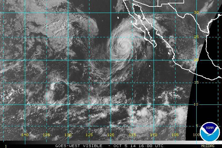
Current Satellite Image

Zola - 10-5-2014 at 10:13 AM

Here is my amateur interpretation of this morning's reporting from the NHS and its models:

Simon became a Category 4 hurricane over the open sea. It rapidly diminished in intensity after reaching waters cooler than 26 degrees celcius (78.8 degrees farenheit), since waters below this threshold cannot support a hurricane.

Simon is now a Category 2 huricane and rapidly diminishing in force. It is expected to become a tropical storm by tomorrow morning if not sooner, and a remnant low later on Monday or on Tuesday.

Simon will likely bring significant rainfall to parts of central and north-cental Baja.

Since there were flooded arroyos in the aftermath of the earlier storms, these arroyos might become flooded again.

Anyone who is considering driving down Highway 1 should wait for the system to pass and leave only after receiving confirmation that the Highway is passable.

Simon generated significant surf, and perhaps the high surf, high tides and rains might pose a problem for exposed areas in central Baja.

I hope this summary helps. If it is not helpful, I will not make the attempt again and apologize in advance. I am new to this, but I have been following this pretty closely.

BajaNomad - 10-5-2014 at 10:13 AM

HURRICANE SIMON ADVISORY NUMBER 16
NWS NATIONAL HURRICANE CENTER MIAMI FL EP192014
800 AM PDT SUN OCT 05 2014

...SIMON CONTINUES TO WEAKEN...
...EXPECTED TO TURN NORTHWARD AND SLOW DOWN SOON...


DISCUSSION AND 48-HOUR OUTLOOK
------------------------------
AT 800 AM PDT...1500 UTC...THE CENTER OF HURRICANE SIMON WAS LOCATED
NEAR LATITUDE 22.9 NORTH...LONGITUDE 117.1 WEST. SIMON IS MOVING
TOWARD THE NORTHWEST NEAR 10 MPH...17 KM/H. A TURN TOWARD THE NORTH
WITH A DECREASE IS FORWARD SPEED IS EXPECTED BY EARLY MONDAY...
FOLLOWED BY A GRADUAL TURN TOWARD THE NORTH-NORTHEAST BY TUESDAY.

MAXIMUM SUSTAINED WINDS HAVE DECREASED TO NEAR 100 MPH...155 KM/H...
WITH HIGHER GUSTS. RAPID WEAKENING IS FORECAST DURING THE NEXT
COUPLE OF DAYS...AND SIMON SHOULD BECOME A TROPICAL STORM BY MONDAY
AND A TROPICAL DEPRESSION BY TUESDAY.

HURRICANE FORCE WINDS EXTEND OUTWARD UP TO 25 MILES...35 KM...FROM
THE CENTER...AND TROPICAL STORM FORCE WINDS EXTEND OUTWARD UP TO 90
MILES...150 KM.

THE ESTIMATED MINIMUM CENTRAL PRESSURE IS 972 MB...28.71 INCHES.

BajaNomad - 10-5-2014 at 10:22 AM

Current IR satellite and computer model projections:

simon-oct5-1020a.jpg - 49kB

CatCrazyJulie - 10-5-2014 at 11:16 AM

Weellllll...we had been planning on heading south today, which would have put us right in the wrong place at the wrong time. But due to unrelated circumstances, our departure date was pushed back a couple of days, to Tuesday; the delay is now looking serendipitous. We can drive down to our friends' house in San Diego and hang out till we get a chance to see what Simon hath wrought.

I feel for the folks in BOLA.

Julie

[Edited on 10-5-2014 by CatCrazyJulie]

Zola - 10-5-2014 at 02:53 PM

Even if Simon will cause no harm as a hurricane, it appears highly likely that it will bring significant rains, which in turn might flood various arroyos in central and southern Baja, making roads impassable.

http://www.accuweather.com/en/weather-news/hurricane-simon-p...

shari - 10-5-2014 at 03:22 PM

looks like our spinning is working to convince Simon to ease on up the coast gently...(above us) and not cross over here.

Last night was a stunning red sunset and the swell was getting bigger.


[URL=http://s1327.photobucket.com/user/labufadorainn/media/Hurricane%20Simon%20Oct%205/DSC00092_zps15301981.jpg.html][IMG]http://i1327.photobucket.com /albums/u673/labufadorainn
/Hurricane%20Simon%20Oct%205/DSC00092_zps15301981.jpg[/IMG][/URL]

today the sky is stunningly dramatic and people are gassing and stocking up ready for the rain. My last load of towels is not drying very fast with all the salt spray from the blowhole out here. I am a wee bit dizzy from spinning but will keep it up.
Here is the view from my laundry line of the coop under some really groovy clouds...o rain as of yet today.


the Islas group is having their event at the beach today and getting a real work out in the waves. I'm glad the weather is holding out for them so far.


[Edited on 10-5-2014 by shari]

Sweetwater - 10-5-2014 at 03:30 PM

Ay, dios mio.....good luck amigos....hope for moderation of another storm.....

BajaNomad - 10-5-2014 at 03:54 PM

HURRICANE SIMON ADVISORY NUMBER 17
NWS NATIONAL HURRICANE CENTER MIAMI FL EP192014
200 PM PDT SUN OCT 05 2014

...NOAA HURRICANE HUNTER AIRCRAFT FINDS SIMON WEAKENING RAPIDLY...


DISCUSSION AND 48-HOUR OUTLOOK
------------------------------
AT 200 PM PDT...2100 UTC...THE CENTER OF HURRICANE SIMON WAS LOCATED
BY NOAA HURRICANE HUNTER AIRCRAFT NEAR LATITUDE 23.4 NORTH...
LONGITUDE 117.5 WEST. SIMON IS MOVING TOWARD THE NORTH-NORTHWEST
NEAR 9 MPH. A TURN TOWARD THE NORTH AT A SLOWER FORWARD SPEED IS
EXPECTED TONIGHT...FOLLOWED BY A TURN TOWARD THE NORTH-NORTHEAST
MONDAY NIGHT.

MAXIMUM SUSTAINED WINDS HAVE DECREASED TO NEAR 75 MPH...120 KM/H...
WITH HIGHER GUSTS. SIMON IS FORECAST TO WEAKEN TO A TROPICAL STORM
SOON...AND IT WILL LIKELY BECOME A REMNANT LOW BY TUESDAY.

HURRICANE FORCE WINDS EXTEND OUTWARD UP TO 25 MILES...35 KM...FROM
THE CENTER...AND TROPICAL STORM FORCE WINDS EXTEND OUTWARD UP TO 105
MILES...165 KM.

THE ESTIMATED MINIMUM CENTRAL PRESSURE IS 977 MB...28.85 INCHES.

BajaNomad - 10-5-2014 at 03:56 PM

HURRICANE SIMON DISCUSSION NUMBER 17
200 PM PDT SUN OCT 05 2014

...Simon is likely to become a tropical
depression in 36 hours and a remnant low by 48 hours, before it
reaches the Baja California peninsula. Forecast fields from the
global models indicate that the cyclone will have dissipated over
northwestern Mexico by day 4, which is indicated in the official
forecast.

The model guidance is in relatively good agreement on the future track of
Simon, but there continues to be disagreement on how fast Simon or
its remnants reach the Baja California peninsula. For example, the
GFS and ECMWF solutions are about 24 hours apart on when they bring
the center of Simon to the coast. The updated NHC track forecast
is a little faster than the previous one after 24 hours but is
relatively close to the multi-model consensus TVCE.

Even if Simon or its remnant circulation does not make it across the
rugged terrain of the Baja California peninsula, deep moisture
associated with the cyclone is expected to spread across the
northern Baja California peninsula, northwestern Mexico, and into
the U.S. Desert Southwest, which could trigger heavy rains in
those regions in a few days.

monoloco - 10-5-2014 at 03:57 PM

We just drove from Loreto to El Rosario today, and other than a few sprinkles around Jesus Maria, it was good weather. It looks like we'll outrun Simon.

BajaNomad - 10-5-2014 at 04:09 PM

.

simon-oct5-408p.jpg - 50kB

BajaNomad - 10-5-2014 at 04:12 PM

.

ep201419_model_zoom.gif - 34kB

shari - 10-5-2014 at 08:30 PM

pretty quiet on here lately...I hear it is raining in Mulege. We have a very light drizzle here and lightening out to sea and 10-15 knots of wind from the south...sure hope I dont have to mop up tonight...gonna try to rest just in case...kind of tired from all that spinning...good night amigos...not sure we will have internet in the morning...wish us luck.

Mulegena - 10-5-2014 at 09:26 PM

Yep, it was raining all evening here in Mulege and up in the mountains to the west. Rain in town stopped about 9 pm tonight.

Two updates:

Word today came down from the mountain family in La Purisima: High-country goat ranchers above Purisima reported the high arroyos running hard today with possibility of drainage arriving down to Mulege. They did not predict vast flooding in Mulege if the rain up there did not continue through the night and into Monday.

10 pm. Word from town is that the far-western colonias and agricultural area of western Mulege are receiving water in the arroyo come down from the mountains. No word if pre-emptive evacuation is taking place.

[Edited on 10-6-2014 by Mulegena]

bajabuddha - 10-5-2014 at 09:44 PM

Mulegena, please update on river flow through the estero. I personally am hoping now the residual dirt is 'mud-flowed' out, the drainage will be more effective. Only time, and unfortunately effect, can prove if worth its' works or not. Praise and protection wished to all .......
bb

Mulegena - 10-5-2014 at 09:50 PM

Quote:
Originally posted by bajabuddha
Mulegena, please update on river flow through the estero. I personally am hoping now the residual dirt is 'mud-flowed' out, the drainage will be more effective. Only time, and unfortunately effect, can prove if worth its' works or not. Praise and protection wished to all .......
bb


Yes, of course, I will update as I receive information. Rain in town has stopped now since about 9 pm.

bajabuddha - 10-5-2014 at 10:00 PM

Quote:
Originally posted by Mulegena
Quote:
Originally posted by bajabuddha
Mulegena, please update on river flow through the estero. I personally am hoping now the residual dirt is 'mud-flowed' out, the drainage will be more effective. Only time, and unfortunately effect, can prove if worth its' works or not. Praise and protection wished to all .......
bb


Yes, of course, I will update as I receive information. Rain in town has stopped now since about 9 pm.

I know you know, but this is just a tertiary storm that you've just had. The heavier moisture is 36 to 72 hours out, given 12. Just know, I'm rootin' fer ya, and I know a couple other curmudgeons who are too. Buena suerte, vecina. (hope my espagnole speling is korekt).

BajaNomad - 10-5-2014 at 10:07 PM

TROPICAL STORM SIMON ADVISORY NUMBER 18
NWS NATIONAL HURRICANE CENTER MIAMI FL EP192014
800 PM PDT SUN OCT 05 2014

...SIMON CONTINUES TO WEAKEN...


DISCUSSION AND 48-HOUR OUTLOOK
------------------------------
AT 800 PM PDT...0300 UTC...THE CENTER OF TROPICAL STORM SIMON WAS
LOCATED NEAR LATITUDE 23.8 NORTH...LONGITUDE 117.6 WEST. SIMON IS
MOVING TOWARD THE NORTH-NORTHWEST NEAR 7 MPH...11 KM/H. A TURN
TOWARD THE NORTH IS EXPECTED TONIGHT...FOLLOWED BY A TURN TOWARD
THE NORTH-NORTHEAST BY MONDAY NIGHT.

MAXIMUM SUSTAINED WINDS HAVE DECREASED TO NEAR 70 MPH...110 KM/H...
WITH HIGHER GUSTS. ADDITIONAL WEAKENING IS EXPECTED DURING THE NEXT
COUPLE OF DAYS...AND SIMON IS FORECAST TO BECOME A REMNANT LOW ON
TUESDAY.

TROPICAL STORM FORCE WINDS EXTEND OUTWARD UP TO 105 MILES...165 KM
FROM THE CENTER.

THE ESTIMATED MINIMUM CENTRAL PRESSURE IS 983 MB...29.03 INCHES.


HAZARDS AFFECTING LAND
----------------------
RAINFALL...SIMON IS EXPECTED TO PRODUCE STORM TOTAL RAINFALL AMOUNTS
OF 3 TO 6 INCHES WITH ISOLATED AMOUNTS AROUND 9 INCHES OVER THE
NEXT SEVERAL DAYS ACROSS CENTRAL AND NORTHERN PORTIONS OF THE BAJA
CALIFORNIA PENINSULA AND THE STATE OF SONORA IN NORTHWESTERN
MEXICO. BEGINNING ON TUESDAY...RAINFALL IS EXPECTED TO SPREAD INTO
PORTIONS OF THE U.S. DESERT SOUTHWEST. THIS RAINFALL COULD CAUSE
FLASH FLOODING AND MUDSLIDES.

SURF...LARGE SWELLS GENERATED BY SIMON ARE AFFECTING PORTIONS OF THE
BAJA CALIFORNIA PENINSULA. SWELLS FROM SIMON ARE ALSO EXPECTED TO
AFFECT PORTIONS OF THE SOUTHERN CALIFORNIA COAST ON MONDAY AND
TUESDAY. THESE SWELLS ARE LIKELY TO CAUSE LIFE-THREATENING SURF AND
RIP CURRENT CONDITIONS. PLEASE CONSULT PRODUCTS FROM YOUR LOCAL
WEATHER OFFICE.

BajaNomad - 10-5-2014 at 10:13 PM

TROPICAL STORM SIMON DISCUSSION NUMBER 18
800 PM PDT SUN OCT 05 2014

Simon is forecast to become a tropical depression
within 36 hours and should degenerate to a remnant low by Tuesday,
before the center reaches the Baja California peninsula.

Even if Simon or its remnant circulation does not make it across the
rugged terrain of the Baja California peninsula, moisture associated
with this system is expected to spread across the northern Baja
California peninsula, northwestern Mexico, and into the U.S. Desert
Southwest, which could trigger heavy rains in those regions during
the next few days.

BajaNomad - 10-5-2014 at 10:18 PM

.

simon-oct5-1017p.jpg - 50kB

Mulegena - 10-5-2014 at 10:37 PM

Quote:
Originally posted by bajabuddha
Quote:
Originally posted by Mulegena
Quote:
Originally posted by bajabuddha
Mulegena, please update on river flow through the estero. I personally am hoping now the residual dirt is 'mud-flowed' out, the drainage will be more effective. Only time, and unfortunately effect, can prove if worth its' works or not. Praise and protection wished to all .......
bb


Yes, of course, I will update as I receive information. Rain in town has stopped now since about 9 pm.

I know you know, but this is just a tertiary storm that you've just had. The heavier moisture is 36 to 72 hours out, given 12. Just know, I'm rootin' fer ya, and I know a couple other curmudgeons who are too. Buena suerte, vecina. (hope my espagnole speling is korekt).
Thanks for your good will. All we Mulegin@s truly appreciate it.
We're also just a little edgy tonight as tertiary storm or no, it's what comes down the western arroyos that makes us antsy.

11 pm Update: The flow has reached the pilings under the bridge. It's not much, not fast, not deep, but it's there and making the river expand it's edges just a bit. My friend Raffita Romero has posted a few pictures on his Facebook page. What a good guy he is.

As to the excavation I can't comment except to say that three weeks post-Odile the river is still running brown at out-going tide.

We'll see how the mountains handle things tonight. Let's hope we're safe & dry and all our dirt roads are still passable in the morning.

bajabuddha - 10-5-2014 at 10:42 PM

Dr. Jeff Master's blog, wunderground.com:

"Simon is expected to recurve to the northeast, and bring rains of 2" - 4" to the central coast of Mexico's Baja Peninsula as it dissipates near landfall on Tuesday. Deep moisture from Simon will flow northeastward across Mainland Mexico and into the Southwest U.S. this week..."

Still a crapshoot, and wishing the best to all. Bottom line is, where Simon crosses will be lots of water, be it Cataviņa, Mulege, or wherever current travelers are headed south. All be wary; I wouldn't want to be headed through it. Please, leave a little extra 'travel-time' like in the Olden Daze when one expected delays. This is still a potential BIG delay.

BajaNomad - 10-6-2014 at 05:13 AM

TROPICAL STORM SIMON ADVISORY NUMBER 19
200 AM PDT MON OCT 06 2014

...SIMON CONTINUES TO WEAKEN WHILE TURNING NORTHWARD...
...EXPECTED TO BECOME A REMNANT LOW ON TUESDAY...


DISCUSSION AND 48-HOUR OUTLOOK
------------------------------
AT 200 AM PDT...0900 UTC...THE CENTER OF TROPICAL STORM SIMON WAS
LOCATED NEAR LATITUDE 24.4 NORTH...LONGITUDE 117.6 WEST. SIMON IS
MOVING TOWARD THE NORTH NEAR 7 MPH...11 KM/H. A TURN TOWARD THE
NORTH-NORTHEAST IS EXPECTED BY TONIGHT OR EARLY TUESDAY.

MAXIMUM SUSTAINED WINDS HAVE DECREASED TO NEAR 60 MPH...95 KM/H...
WITH HIGHER GUSTS. ADDITIONAL WEAKENING IS EXPECTED DURING THE
NEXT COUPLE OF DAYS...AND SIMON IS FORECAST TO BECOME A REMNANT LOW
ON TUESDAY.

TROPICAL STORM FORCE WINDS EXTEND OUTWARD UP TO 90 MILES...150 KM
FROM THE CENTER.

THE ESTIMATED MINIMUM CENTRAL PRESSURE IS 994 MB...29.36 INCHES.


HAZARDS AFFECTING LAND
----------------------
RAINFALL...SIMON IS EXPECTED TO PRODUCE STORM TOTAL RAINFALL AMOUNTS
OF 3 TO 6 INCHES WITH ISOLATED AMOUNTS AROUND 9 INCHES OVER THE
NEXT SEVERAL DAYS ACROSS CENTRAL AND NORTHERN PORTIONS OF THE BAJA
CALIFORNIA PENINSULA AND THE STATE OF SONORA IN NORTHWESTERN
MEXICO. BEGINNING ON TUESDAY...RAINFALL IS EXPECTED TO SPREAD INTO
PORTIONS OF THE U.S. DESERT SOUTHWEST. THIS RAINFALL COULD CAUSE
FLASH FLOODING AND MUD SLIDES.

SURF...LARGE SWELLS GENERATED BY SIMON ARE AFFECTING PORTIONS OF THE
BAJA CALIFORNIA PENINSULA. SWELLS FROM SIMON ARE ALSO EXPECTED TO
AFFECT PORTIONS OF THE SOUTHERN CALIFORNIA COAST ON MONDAY AND
TUESDAY. THESE SWELLS ARE LIKELY TO CAUSE LIFE-THREATENING SURF AND
RIP CURRENT CONDITIONS. SWELLS SHOULD BEGIN TO SUBSIDE ON WEDNESDAY
THROUGHTOUT THESE AREAS.

BajaNomad - 10-6-2014 at 05:34 AM

.

simon-oct6-528a.jpg - 50kB

Pescador - 10-6-2014 at 07:03 AM

Thanks Mulegena. Got reports from San Bruno and Santa Rosalia that it was raining pretty hard. I am trying to haul down a travel trailer from Phoenix so guess I will watch this a little bit maybe at Tecate or somewhere before I head across the desert.

larryC - 10-6-2014 at 07:27 AM

So far in BoLA we are only getting light sprinkles, but everyone here is hoping for the best.

shari - 10-6-2014 at 07:30 AM

buen dia amigo storm watchers...we had a lovely gentle rain much of the night so I was able to sleep and only got up a few times to check things on the prestorm warm up. So the ground is saturated now, we have cloudy skies with about 15 knots of wind from the south east. Sounds like tonight and tomorrow morning will be the worst of it with rain, 16' waves and 35 knots of wind...so be it.

Anybody else out there with a report....looks to be raining in central baja...anyone in BOLA getting rain yet?

Vince - 10-6-2014 at 07:31 AM

The high clouds from Simon are even reaching the San Diego area this morning presenting a beautiful sunrise.

Mula - 10-6-2014 at 07:33 AM

The heavy rain came Saturday in Lopez while we were gone, so came home to lots of water in the streets again, but other than that - nothing here.

Insurgentes really got poured on yesterday afternoon.

Maybe the road to La Purisima and San Juanico is out again for road flooding.

woody with a view - 10-6-2014 at 08:05 AM

we need fotos!!!!

awesome sunrise in Yuma also Vince! storm clouds are gathering to the south.

shari - 10-6-2014 at 08:12 AM

It's not often we get a sunrise like this! brooding all right


there was even some blue sky over the island


bowser - 10-6-2014 at 09:17 AM

A few drops of rain at 8:00 AM in BOLA but nothing now. Those of us with "modified" beach fronts are scrambling while we can.

Mexitron - 10-6-2014 at 09:28 AM

Nice pics Shari! Hope you get some good rains but no damage.

pappy - 10-6-2014 at 10:23 AM

great pics shari!

shari - 10-6-2014 at 10:55 AM

thanks....dang it, I just took some great ones of a big squall coming and didnt have the SIM card in the camera...sheesh! Just got a heckova gulleywasher! There are rain cells all around and wind was about 25-30 knots

wessongroup - 10-6-2014 at 11:18 AM

:lol::lol: who's perfect :):)

LaTijereta - 10-6-2014 at 11:26 AM

Quote:
Originally posted by Mula
The heavy rain came Saturday in Lopez while we were gone, so came home to lots of water in the streets again, but other than that - nothing here.


Is the Ice House back open yet in Lopez? Heard the roof dropped in from the last storm....

micah202 - 10-6-2014 at 12:26 PM

.
...amazing pictures,,I hope you get used to those clouds,, me's not quite sure what you've been doing there,Shari....but it's looking like you've managed to create a stand-off not only for Asuncion,,but the whole coast!:O:wow:

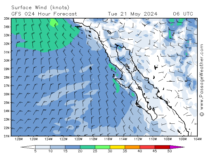
....the latest animation for passageweather.com shows a break-down that maxes with 25-30mph winds and 3-4 meter waves--what a difference a day makes!!......it looks like the storm will dissipate at your doorstep,,,but the rains might hang around ~week

...it's worth visiting the site,, looking at the animation.............


[Edited on 10-6-2014 by micah202]

bajacalifornian - 10-6-2014 at 12:37 PM


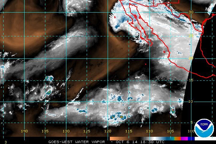
Current Water Vapor

shari - 10-6-2014 at 01:19 PM

we have about 30 knots of wind and rain squalls every once in awhile.

I am getting good at spinning and spell casting eh...looks like that sucker just blew right by us...hehehe! There are even patches of blue sky here and there...whew

mtgoat666 - 10-6-2014 at 01:33 PM

north central baja gonna get some rain!
arroyos gonna flow!

are these hurricane rains coming too early to effect the spring desert wildflowers of north central baja? will the GOOD wildflowers have a fall bloom in this period of shortened days?

Cisco - 10-6-2014 at 01:48 PM

Quote:
Originally posted by wessongroup
:lol::lol: who's perfect :):)


MrBillM

Mexitron - 10-6-2014 at 01:52 PM

Quote:
Originally posted by mtgoat666
north central baja gonna get some rain!
arroyos gonna flow!

are these hurricane rains coming too early to effect the spring desert wildflowers of north central baja? will the GOOD wildflowers have a fall bloom in this period of shortened days?


Mixed answer. Some plants are summer bloomers after chubascos, some are cool season bloomers. Likely the temps are too hot for the cool season plants to get going. But, there are many plants that will grow and bloom whenever they get rain---sand verbena, coreopsis, and encelia come to mind for bloomers...Ocotillo, Elephant Trees, Cardon and other cactii, Creosote, and Ironwood are some of the many larger plants in that category.

MP - 10-6-2014 at 02:07 PM

I so hope we get some rain!
The wells are just about dry in the Ensenada area.

Mula - 10-6-2014 at 02:21 PM

LaTijereta,
Didn't know the roof fell in.
The Metal on the roof that is a cover for the coolers for the ice machines is all crumpled up and looking wrecked, but the ice house it's self is fine.
Been buying ice there since the power came back on.

We only had about 14 hours of strong winds and a few light gusts for Odile. Trees and power poles are the main things that fell - here in Lopez.

BajaBlanca - 10-6-2014 at 02:40 PM

well, the chubasco here is - again -a NON EVENT.

we so far have had a breeze, sprinkles, clouds and small waves.

Shari - your cloud pics are just spectacular!

Now, this is a new plant that I bought in San Miguel de Allende when we were there. It is endemic to Mexico and it just flowered!


I doubt it had anything to do with the chubasco, but you never know. It is such a tiny plant and gives me great pleasure.

Udo - 10-6-2014 at 02:48 PM

That's a cute puppy cactus flower, Blanca.

LaTijereta - 10-6-2014 at 03:47 PM

Quote:
Originally posted by Mula
LaTijereta,
Didn't know the roof fell in.
The Metal on the roof that is a cover for the coolers for the ice machines is all crumpled up and looking wrecked, but the ice house it's self is fine.
Been buying ice there since the power came back on.


Good News!.. Hope to be over later this week to fill the chests..

Mula - 10-6-2014 at 04:38 PM

Thursday, Friday and Saturday are supposed to be the best tides and currents this week.

Give me a call or stop by when you are here.

Mulege Pueblo reporting in

Mulegena - 10-6-2014 at 06:44 PM

We got wet. When we gets wet we gets muddy, 'waaay muddy!

It was thick 'n nasty slip-in-cow-poop slick and to-your-hubcaps deep in fresh, wet mud on the Lighthouse Road into town this morning, really a 4wd couple of miles but keeping it in first gear, not getting too close to the car in front and keeping the rpm's up, all made it to and fro'. We all got bogged down but nobody got stuck. By afternoon most of the road was stable and quite dry.

Worse damage was suffered by the recently filled-in culvert spanning the river under the highway bridge. It was destroyed three weeks ago by Hurricane Odile's flood waters, just temporarily filled with dirt making it one lane but passable. It all washed out during the night's rain and the minimal flooding that came down the arroyos east of town.

We pick up, scrape off, wash up, give a spit-shine and go on... yet again.
We're Mulegin@s one and all. It's who we are and what we do.

Bob and Susan - 10-6-2014 at 07:20 PM

mex1 at mulege to santa rosalia clear...

the repaired areas good ...any car can pass no sweat

the bay got a lot of water but its gone...
normal now

bajacalifornian - 10-6-2014 at 07:29 PM

I for one, feel good hearing from you, those who made the decision of heart
to be there.


Let the remaining rain miss you.

bajacalifornian - 10-6-2014 at 07:52 PM


Current water vapor, and perhaps reason for blue sky and smiles . . .

BajaNomad - 10-6-2014 at 08:09 PM

TROPICAL STORM SIMON ADVISORY NUMBER 22
800 PM PDT MON OCT 06 2014

...SIMON EXPECTED TO WEAKEN BUT COULD BRING TROPICAL STORM FORCE
WINDS TO PORTIONS OF THE CENTRAL BAJA PENINSULA OVERNIGHT...


WATCHES AND WARNINGS
--------------------
SUMMARY OF WATCHES AND WARNINGS IN EFFECT...

A TROPICAL STORM WATCH IS IN EFFECT FOR...
* PUNTA ABREOJOS TO PUNTA EUGENIA

A TROPICAL STORM WATCH MEANS THAT TROPICAL STORM CONDITIONS ARE
POSSIBLE WITHIN THE WATCH AREA...IN THIS CASE WITHIN THE NEXT 12 TO
24 HOURS.


DISCUSSION AND 48-HOUR OUTLOOK
------------------------------
AT 800 PM PDT...0300 UTC...THE CENTER OF TROPICAL STORM SIMON WAS
LOCATED NEAR LATITUDE 26.5 NORTH...LONGITUDE 117.2 WEST. SIMON IS
MOVING TOWARD THE NORTH-NORTHEAST NEAR 8 MPH...13 KM/H...AND THIS
GENERAL MOTION IS EXPECTED TO CONTINUE DURING THE NEXT DAY OR TWO.

MAXIMUM SUSTAINED WINDS ARE NEAR 45 MPH...75 KM/H...WITH HIGHER
GUSTS. WEAKENING IS FORECAST DURING THE NEXT 48 HOURS....AND SIMON
IS EXPECTED TO BECOME A REMNANT LOW ON TUESDAY.

TROPICAL STORM FORCE WINDS EXTEND OUTWARD UP TO 105 MILES...165 KM
FROM THE CENTER.

THE ESTIMATED MINIMUM CENTRAL PRESSURE IS 1000 MB...29.53 INCHES.


HAZARDS AFFECTING LAND
----------------------
RAINFALL...SIMON IS EXPECTED TO PRODUCE STORM TOTAL RAINFALL AMOUNTS
OF 3 TO 6 INCHES WITH ISOLATED AMOUNTS AROUND 9 INCHES OVER THE NEXT
FEW DAYS ACROSS CENTRAL AND NORTHERN PORTIONS OF THE BAJA CALIFORNIA
PENINSULA AND THE STATE OF SONORA IN NORTHWESTERN MEXICO. STARTING
LATER TUESDAY AND CONTINUING THROUGH WEDNESDAY...RAINFALL FROM SIMON
OR ITS REMNANTS IS EXPECTED TO SPREAD INTO PORTIONS OF THE U.S.
DESERT SOUTHWEST. THIS RAINFALL COULD CAUSE FLASH FLOODING AND MUD
SLIDES.

WIND...WINDS TO TROPICAL STORM FORCE ARE POSSIBLE WITHIN THE WATCH
AREA OVER CENTRAL BAJA CALIFORNIA TONIGHT THROUGH EARLY TUESDAY.

SURF...LARGE SWELLS GENERATED BY SIMON WILL AFFECT PORTIONS
OF THE BAJA CALIFORNIA PENINSULA AND THE COAST OF SOUTHERN
CALIFORNIA THROUGH TUESDAY. THESE SWELLS ARE LIKELY TO CAUSE
LIFE-THREATENING SURF AND RIP CURRENT CONDITIONS.

BajaNomad - 10-6-2014 at 08:11 PM

TROPICAL STORM SIMON DISCUSSION NUMBER 22
800 PM PDT MON OCT 06 2014

Simon is expected to degenerate into a post-tropical cyclone by late Tuesday
and dissipate within 2 to 3 days.

Even if Simon or its remnant circulation does not make it across the
rugged terrain of the Baja California peninsula, moisture associated
with this system is expected to spread across the northern Baja
California peninsula, northwestern Mexico, and into the U.S. Desert
Southwest, which could trigger heavy rains in those regions during
the next few days.

BajaNomad - 10-6-2014 at 08:20 PM

.

simon-oct6-816p.jpg - 49kB

Whale-ista - 10-6-2014 at 09:02 PM

Love the baby cacti blossoms!

Hoping for a primavera verde for the ride down south to see whales in 2015.

Quote:
Originally posted by BajaBlanca
well, the chubasco here is - again -a NON EVENT.

we so far have had a breeze, sprinkles, clouds and small waves.

Shari - your cloud pics are just spectacular!

Now, this is a new plant that I bought in San Miguel de Allende when we were there. It is endemic to Mexico and it just flowered!


I doubt it had anything to do with the chubasco, but you never know. It is such a tiny plant and gives me great pleasure.

bajacalifornian - 10-6-2014 at 09:10 PM

I've looked at hurricanes from both sides now.

Loreto, untrimmed palms stretch sideways straight out, only to be released by the wind to spring straight out the other direction. Odile took three palms out from the back of my home in Loreto. Each palm, taking out what was in the way.

Tonight, I just came in from watching the waves, sitting on a park bench at the top of a cliff, k38 or so Rosarito . . .

The waves have arrived.

Each wave strikes the base of my cliff, booms propelled toward the night sky (my dog huddles close to me on top of our bench, same as she does with fireworks). Each wave brings spray to my eye level. With most sets, come a blow

15-20 feet higher.

BornFisher left on the Blues Cruise. He's out there somewhere. He'd miss it here.

San Diego:cooler, hi clouds, no rain.. yet?

Whale-ista - 10-6-2014 at 09:11 PM

This is supposedly the season of "Santa Ana" heat and dry winds- so many of us are grateful that the northern reaches of Simon have cooled and dampened us here, just north of the border.

No rain, but hi clouds, lovely sunrise, and a very nice change from the heat and low humidity over the last several days.

mulegemichael - 10-6-2014 at 09:33 PM

thanks, lisa maria, for your update....we, of course, are up here, out of the way, just feeling badly for the folks that have to go through it again, and again, and again.....we have sent relief...in our own way....talk to richard or engineer mike...stuff's comin'

shari - 10-6-2014 at 10:09 PM

We are
Taking a beating tonight with at least 40
Knot wind & heavy rain....dang! I stopped spinning too soon. man the mop & towels. Juan was right...should have covered the windows!

shari - 10-6-2014 at 11:03 PM

This deluge will really screw up some roads here. My hands hurt already after only an hour of towel wringing...get ready for rain up north! I am surprised we still have power & internet

David K - 10-6-2014 at 11:38 PM

Thanks Shari for the live reporting... the water will dry up, get some rest! Make sure there are no electric cords on the ground and don't touch anything electric while your feet are wet!

BajaNomad - 10-7-2014 at 05:53 AM

TROPICAL STORM SIMON INTERMEDIATE ADVISORY NUMBER 23A
NWS NATIONAL HURRICANE CENTER MIAMI FL EP192014
500 AM PDT TUE OCT 07 2014

...HEAVY RAINS CONTINUING OVER PORTIONS OF THE BAJA CALIFORNIA
PENINSULA...


WATCHES AND WARNINGS
--------------------
SUMMARY OF WATCHES AND WARNINGS IN EFFECT...

A TROPICAL STORM WATCH IS IN EFFECT FOR...
* PUNTA ABREOJOS TO PUNTA EUGENIA

A TROPICAL STORM WATCH MEANS THAT TROPICAL STORM CONDITIONS ARE
POSSIBLE WITHIN THE WATCH AREA...IN THIS CASE WITHIN THE NEXT 6 TO
12 HOURS.


DISCUSSION AND 48-HOUR OUTLOOK
------------------------------
AT 500 AM PDT...1200 UTC...THE CENTER OF TROPICAL STORM SIMON WAS
LOCATED NEAR LATITUDE 27.4 NORTH...LONGITUDE 116.9 WEST. SIMON IS
MOVING TOWARD THE NORTH-NORTHEAST NEAR 7 MPH...11 KM/H...AND THIS
MOTION IS EXPECTED TO CONTINUE DURING THE NEXT 24 TO 36 HOURS.

MAXIMUM SUSTAINED WINDS ARE NEAR 40 MPH...65 KM/H...WITH HIGHER
GUSTS. SIMON IS FORECAST TO WEAKEN TO A REMNANT LOW LATER TODAY OR
WEDNESDAY.

TROPICAL STORM FORCE WINDS EXTEND OUTWARD UP TO 90 MILES...150 KM
FROM THE CENTER.

THE ESTIMATED MINIMUM CENTRAL PRESSURE IS 1002 MB...29.59 INCHES.


HAZARDS AFFECTING LAND
----------------------
RAINFALL...SIMON IS EXPECTED TO PRODUCE STORM TOTAL RAINFALL AMOUNTS
OF 3 TO 6 INCHES WITH ISOLATED AMOUNTS AROUND 9 INCHES OVER THE NEXT
FEW DAYS ACROSS CENTRAL AND NORTHERN PORTIONS OF THE BAJA CALIFORNIA
PENINSULA AND THE STATE OF SONORA IN NORTHWESTERN MEXICO. OVER THE
NEXT FEW DAYS...STORM TOTAL RAINFALL AMOUNTS OF 1 TO 2 INCHES WITH
ISOLATED AMOUNTS OF AROUND 4 INCHES ARE EXPECTED ACROSS PORTIONS OF
ARIZONA. THIS RAINFALL COULD CAUSE FLASH FLOODING AND MUD SLIDES.

WIND...WINDS TO TROPICAL STORM FORCE ARE STILL POSSIBLE WITHIN THE
WATCH AREA TODAY.

SURF...LARGE SWELLS GENERATED BY SIMON WILL AFFECT PORTIONS OF THE
BAJA CALIFORNIA PENINSULA AND THE COAST OF SOUTHERN CALIFORNIA
TODAY. THESE SWELLS ARE LIKELY TO CAUSE LIFE-THREATENING SURF AND
RIP CURRENT CONDITIONS.

BajaNomad - 10-7-2014 at 06:00 AM

.

simon-oct7-555a.jpg - 50kB

BajaBlanca - 10-7-2014 at 06:03 AM

We have winds that are stronger but not really bad at all.

No rain now but it rained a little during the night. Enough for my plants but not the trees, according to hubby. I slept right thru it all.

Waves will supposedly get bigger today. All boats have been banned from going out by the Capitania de Puertos in Santa Rosalia, according to the livespeaker they sent thru town yesterday.

Isn't it just amazing how towns so close to one another can have such diverse experiences? Bahia Asuncion is just 1.5 hours north of us but seems like you sure take a banging. Hang in there, Shari and gang!

shari - 10-7-2014 at 06:32 AM

buen dia all...what a night! and what a difference a few miles make eh Blanca. We are still experiencing gale force winds but thank goodness the driving rain stopped around 2 in the morning as far as I remember. Got some drying out to do today and I am amazed we still have power and internet. I wonder what the roads look like. The waves are about 12' still it looks like...I am about to do a drive about to see how town looks.

woody with a view - 10-7-2014 at 06:50 AM

Yuma is seeing the beginnings of the rain. I hope BdLA doesn't get whacked again.

bowser - 10-7-2014 at 07:55 AM

Still nothing in BOLA. Very still. Some patches of blue and some ugly sky.

24baja - 10-7-2014 at 07:57 AM

Very humid in BOLA and cloudy but no rain or wind as yet. Having internet problems tho.

shari - 10-7-2014 at 08:20 AM

this time we are taking the brunt of the storm out at the point and town isnt too bad. The direction of the gale winds (I can barely stand up in the wind) is driving the waves up the cliff by our house so the spray is hitting our house...pretty exciting stuff...camera battery just died...hope the video comes out!

Town has some mud where the streets dirt washed down but not too bad at all and big puddles in the usual places but the highway is clear. I wonder how bahia tortugas & Cedros Island & Guerrero Negro fared?

Bob H - 10-7-2014 at 09:46 AM

Wow, some rain here in San Diego.... sprinkles so far.

Glad to hear that everyone seems to be OK!!

Mulegena - 10-7-2014 at 09:47 AM

Good to hear from Asuncion, Shari. Glad you're all ok.

Just saw a photo on Facebook Vizcaino Hoy's page: Isla Cedros flash flooding this morning!
:(

shari - 10-7-2014 at 10:13 AM

this is the worst storm of the summer for us...I imagine Cedros is kicking butt too. Still blowing a gale but no rain...whew...we were due!:o

Pescador - 10-7-2014 at 10:13 AM

Ensenada is cloudy but no rain. Gonna check again at San Quintin

BajaRat - 10-7-2014 at 10:24 AM

Clouds started yesterday from Simon's first bands, heavy rain with local flooding forecast for NE Az Wed Thurs. We flooded with Norbert here but its taking a bight out of our drought conditions so we'll take it. Looks like Gonzaga might soak again.
Hope all you folks south are faring well.

[Edited on 10-7-2014 by BajaRat]

shari - 10-7-2014 at 10:54 AM

Simon is still kicking a$$ here in Asuncion...raining again a bit too...crap. My ears wont unplug...good thing is the tide is going out now....going for a pina colada at Keykos to cheer me up a bit!

micah202 - 10-7-2014 at 10:59 AM

.
.....it looks like Simon appreciates whatever it is you did to alter him,,,plans to 'hang-out' for a couple of days,,,rainwise at least :smug:

BajaGringo - 10-7-2014 at 11:05 AM

We got some pretty good rain last night out here on the beach at La Chorera as well as a good 20 minute shower that just now stopped. My contacts in San Quintin on the other side of the volcanoes tell me they hardly saw a drop...

Archie - 10-7-2014 at 11:20 AM

Here in GN started drizling yesterday, last night around 9-10 pm heavy rains and wind blowing hard.

Today seems everything is fine, muddy streets, hot and very humid. Internet, celular and land phone working just fine.

I can see some clearing away to S-SE, somewhere over Santa Clara, West (to Cedros) East (To ejido Juarez) and North (Nuevo Rosarito) looks pretty dark and heavy clouds keep passing by.

Heard from a semi driver, that peninsular hwy is passable from Ensenada to GN, pay extra attention to vados an running arroyos.

Zola - 10-7-2014 at 11:47 AM

Please keep these on-the-ground report coming! Shari, I hope everything is ok for you!

David K - 10-7-2014 at 12:43 PM

Rained a little in San Diego this morning. :wow:

shari - 10-7-2014 at 12:46 PM

wow Simon likes it here I guess....still 30 plus knots of wind and rain squalls so be aware north of here there is more to come!!!! peein down right now!

BajaNomad - 10-7-2014 at 12:51 PM

TROPICAL STORM SIMON INTERMEDIATE ADVISORY NUMBER 24A
1100 AM PDT TUE OCT 07 2014

...SIMON LIKELY TO BECOME A REMNANT LOW SOON...


WATCHES AND WARNINGS
--------------------
SUMMARY OF WATCHES AND WARNINGS IN EFFECT...

A TROPICAL STORM WATCH IS IN EFFECT FOR...
* PUNTA ABREOJOS TO PUNTA EUGENIA


DISCUSSION AND 48-HOUR OUTLOOK
------------------------------
AT 1100 AM PDT...1800 UTC...THE CENTER OF TROPICAL STORM SIMON WAS
LOCATED NEAR LATITUDE 27.8 NORTH...LONGITUDE 116.4 WEST. SIMON IS
MOVING TOWARD THE NORTH-NORTHEAST NEAR 7 MPH...11 KM/H...AND THIS
GENERAL MOTION IS EXPECTED TO CONTINUE FOR THE NEXT 24 TO 36 HOURS.

MAXIMUM SUSTAINED WINDS ARE NEAR 40 MPH...65 KM/H...WITH HIGHER
GUSTS. WEAKENING IS FORECAST DURING THE NEXT DAY OR SO...AND
SIMON IS LIKELY TO BECOME A REMNANT LOW BY TONIGHT.

TROPICAL STORM FORCE WINDS EXTEND OUTWARD UP TO 105 MILES...165 KM
FROM THE CENTER.

THE ESTIMATED MINIMUM CENTRAL PRESSURE IS 1002 MB...29.59 INCHES.

simon-oct7-1246p.jpg - 50kB

OCEANUS - 10-7-2014 at 04:22 PM

It sounds and looks as if LA Bay dodged a bullet. Can anyone confirm this?

BajaNomad - 10-7-2014 at 04:59 PM

TROPICAL DEPRESSION SIMON ADVISORY NUMBER 25
NWS NATIONAL HURRICANE CENTER MIAMI FL EP192014
200 PM PDT TUE OCT 07 2014

...SIMON WEAKENS TO A DEPRESSION...


WATCHES AND WARNINGS
--------------------
CHANGES WITH THIS ADVISORY...

THE GOVERNMENT OF MEXICO HAS DISCONTINUED THE TROPICAL STORM WATCH
FROM PUNTA ABREOJOS TO PUNTA EUGENIA.

SUMMARY OF WATCHES AND WARNINGS IN EFFECT...

NONE.


DISCUSSION AND 48-HOUR OUTLOOK
------------------------------
AT 200 PM PDT...2100 UTC...THE CENTER OF TROPICAL DEPRESSION SIMON
WAS LOCATED NEAR LATITUDE 27.9 NORTH...LONGITUDE 116.3 WEST. THE
DEPRESSION IS MOVING TOWARD THE NORTH-NORTHEAST NEAR 7 MPH...11 KM/H
...AND THIS GENERAL MOTION WITH A SLIGHT INCREASE IN FORWARD SPEED
IS EXPECTED FOR THE NEXT 24 TO 36 HOURS.

MAXIMUM SUSTAINED WINDS HAVE DECREASED TO NEAR 35 MPH...55
KM/H...WITH HIGHER GUSTS. WEAKENING IS FORECAST DURING THE NEXT DAY
OR SO...AND SIMON IS EXPECTED TO BECOME A REMNANT LOW BY TONIGHT.

THE ESTIMATED MINIMUM CENTRAL PRESSURE IS 1003 MB...29.62 INCHES.

simon-oct7-457p.jpg - 50kB

 Pages:  1  2