BajaNomad

Tis the season - Dual Hurricanes: Andres & Blanca

 Pages:  1  2  

Katiejay99 - 6-6-2015 at 05:57 AM

There is a nervousness in the air in Todos Santos. I hear stories of children being truly scared to death of the oncoming storm. Hurricane Odile made everyone here stand up and take notice and the poor children were traumatized.

During the past month the powers that be decided that it was the perfect time to put in underground electricity which means they dug up all of our downtown streets. So now we are going to have one MUDDY MUDDY downtown.

I am getting outdoor hanging lights taken down and stored away today as well as outdoor furniture and anything that could be swept up and away. Being a block from the ocean I have nothing to protect the property. I have lived here for 19 years and I have never heard of doing this in JUNE!! Unbelievable.

I hear that CFE has already brought over 75 service trucks from the mainland just waiting to be needed. Good for them!

On edit: It is overcast with little to no breeze here right now. You can hear the waves thundering on the shore.

[Edited on 6-6-2015 by Katiejay99]

pauldavidmena - 6-6-2015 at 06:27 AM

I hope you and the dogs remain safe and that any damage to your property is minimal. It's too soon after Odile to be going through this again!

Hook - 6-6-2015 at 06:32 AM

"During the past month the powers that be decided that it was the perfect time to put in underground electricity which means they dug up all of our downtown streets. So now we are going to have one MUDDY MUDDY downtown."

That's astoundingly bad planning, given that it couldnt be done without CFE and their own federal govt. weather prognosticators have predicted an active and wet hurricane season.

Todos Santos may see as much rain as any lowland location in Baja.

[Edited on 6-6-2015 by Hook]

SFandH - 6-6-2015 at 06:40 AM

Quote: Originally posted by Hook  
"During the past month the powers that be decided that it was the perfect time to put in underground electricity which means they dug up all of our downtown streets. So now we are going to have one MUDDY MUDDY downtown."

That's astoundingly bad planning, given that it couldnt be done without CFE and their own federal govt. weather prognosticators have predicted an active and wet hurricane season.

Todos Santos may see as much rain as any lowland location in Baja.

[Edited on 6-6-2015 by Hook]


Perhaps the timing is based upon the tourist $eason.

SFandH - 6-6-2015 at 06:45 AM

just discovered that when you click anywhere in the following graphic, lat/long and the wind vector are displayed.

http://earth.nullschool.net/#current/wind/surface/level/orth...


Katiejay99 - 6-6-2015 at 06:51 AM

Hey SFandH - How cool is THAT??? I just saved it to my bookmarks. Thank you so much for sharing.

SFandH - 6-6-2015 at 06:54 AM

Quote: Originally posted by Katiejay99  
Hey SFandH - How cool is THAT??? I just saved it to my bookmarks. Thank you so much for sharing.


I read about the guy who wrote the code for the web page. He did it to learn javascript programming. I'd say he learned it well. You can get the code for free if you're so inclined.

SFandH - 6-6-2015 at 07:02 AM

Here's the weather at the Cabo and La Paz airports, updated hourly.

Cabo - http://weather.noaa.gov/weather/current/MMSD.html

La Paz - http://weather.noaa.gov/weather/current/MMLP.html

Katiejay99 - 6-6-2015 at 07:07 AM

I would love to have the code. How do I get it? My son is a programmer and I will pass it to him with some ideas for this area specifically.

Thanks for the Links!!

shari - 6-6-2015 at 07:11 AM

I am getting messages from worried home owners here...what me worry? Nah...which is exactly the problem..one becomes complacent as most storms have gone around us either west or east but we are spared the brunt of it on this nifty bit of baja that sticks out into the Pacific. We will certainly keep an eye on it as long as we have internet anyway...batten down the hatches amigo...Blanca is gonna be knocking on our puertas! Be safe..dont travel in the rain.

But we are taking precautions, solar lights charged, think about taking the antenna down, princess phone ready, water, beer, candles, plants sheltered, sand bags ready for doors...you know, the usual.

chuckie - 6-6-2015 at 07:18 AM

Atta girl...I am hoping for a fizzle and it turns out to be good practice, and all have a Hurricane party....be careful.....luvya

SFandH - 6-6-2015 at 07:57 AM

Quote: Originally posted by Katiejay99  
I would love to have the code. How do I get it? My son is a programmer and I will pass it to him with some ideas for this area specifically.

Thanks for the Links!!


Here's a link to the source code:

https://github.com/cambecc/earth


Katiejay99 - 6-6-2015 at 08:02 AM

THANKS!!

Man oh Man is it getting hot and extremely humid in Todos Santos right now!

Cat 4; currently 130mph sustained winds

BajaNomad - 6-6-2015 at 08:21 AM

HURRICANE BLANCA ADVISORY NUMBER 24
900 AM MDT SAT JUN 06 2015

...BLANCA WITH 130 MPH-WINDS...
...ANOTHER AIR FORCE RECONNAISSANCE PLANE EN ROUTE TO CHECK
BLANCA...

SUMMARY OF 900 AM MDT...1500 UTC...INFORMATION
----------------------------------------------
LOCATION...17.7N 109.4W
ABOUT 305 MI...490 KM SW OF CABO CORRIENTES MEXICO
ABOUT 360 MI...580 KM S OF CABO SAN LUCAS MEXICO
MAXIMUM SUSTAINED WINDS...130 MPH...215 KM/H
PRESENT MOVEMENT...NW OR 325 DEGREES AT 10 MPH...17 KM/H
MINIMUM CENTRAL PRESSURE...943 MB...27.85 INCHES


DISCUSSION AND 48-HOUR OUTLOOK
------------------------------
At 900 AM MDT (1500 UTC), the eye of Hurricane Blanca was located
near latitude 17.7 North, longitude 109.4 West. Blanca is moving
toward the northwest near 10 mph (17 km/h), but a turn toward the
north-northwest is forecast by tonight. On the forecast track, the
center of Blanca is expected to be near the southwest coast of Baja
California Sur in the warning area late Sunday.

Satellite estimates indicate that the maximum sustained winds
have increased to near 130 mph (215 km/h) with higher gusts. Blanca
is a category 4 hurricane on the Saffir-Simpson Hurricane Wind
Scale. Some weakening should begin on Sunday. Another Air Force
reconnaissance plane is en route to check Blanca.

Hurricane force winds extend outward up to 60 miles (95 km) from the
center and tropical storm force winds extend outward up to 175 miles
(280 km).


HAZARDS AFFECTING LAND
----------------------
WIND: Tropical storm conditions are expected to first reach the
warning area on Sunday, making outside preparations difficult or
dangerous. Hurricane conditions are possible in the hurricane
watch area Sunday and Sunday night. Tropical storm conditions are
possible within the tropical storm watch area starting Sunday night.

RAINFALL: Blanca is expected to produce total rain accumulations of
6 to 10 inches over much of Baja California Sur and the southern
portion of the state of Baja California, with possible isolated
maximum amounts of 15 inches over Baja California Sur. These rains
could produce life threatening flash floods and mudslides.

SURF: Swells generated by Blanca are affecting the coast of
southwestern Mexico, the Pacific coast of the Baja California
peninsula, and the southern Gulf of California. These swells are
likely to cause life-threatening surf and rip current conditions.
For additional information, please consult products from your local
weather office.


HURRICANE BLANCA DISCUSSION NUMBER 24
900 AM MDT SAT JUN 06 2015

Blanca has made a significant comeback since yesterday. Satellite
images show a much better organized cloud pattern with a distinct
eye surrounded by very deep convection. The outflow is also well
established in all quadrants. The latest Dvorak estimates from TAFB
and SAB indicate that the winds are up to 115 kt, making Blanca a
category 4 hurricane again on the Saffir/Simpson hurricane wind
scale. A weakening trend should begin tonight or early Sunday when
the hurricane encounters cool waters around 20 degrees North.
The weakening should occur even faster as the cyclone approaches
the west coast of the southern Baja California peninsula. The effect
of the high terrain and increasing shear will cause the cyclone
to become a remnant low in about 3 days.

Satellite fixes suggest that Blanca is moving toward the northwest
or 325 degrees at 9 kt. The steering controlling the motion of
of Blanca remains unchanged. The hurricane is expected to continue
toward the northwest and then north-northwestward around the
periphery of mid-level high centered over northern Mexico and
southwestern Texas. The southerly flow ahead of an approaching
trough will also contribute to the northward motion of Blanca. The
NHC forecast follows the track guidance which, in fact, continues to
be in very good agreement, and it gives more weight to the consensus
of the GFS and the ECMWF models.

Moisture associated with Blanca is moving northward and could help
produce heavy rainfall over portions of southwestern Mexico during
the next day or so, especially in areas of mountainous terrain.


FORECAST POSITIONS AND MAX WINDS

INIT 06/1500Z 17.7N 109.4W 115 KT 130 MPH
12H 07/0000Z 18.8N 110.1W 115 KT 130 MPH
24H 07/1200Z 20.5N 110.6W 95 KT 110 MPH
36H 08/0000Z 22.5N 111.2W 70 KT 80 MPH
48H 08/1200Z 24.5N 112.0W 45 KT 50 MPH
72H 09/1200Z 28.5N 113.5W 25 KT 30 MPH...POST-TROP/REMNT LOW
96H 10/1200Z...DISSIPATED


http://www.nhc.noaa.gov/?epac


20150606-821a.jpg - 71kB

bajalorena - 6-6-2015 at 09:05 AM

Another site with graphics, and you can activate the movement showing where the current track is.
https://www.windyty.com/?21.412,-108.218,4

David K - 6-6-2015 at 09:47 AM

Quote: Originally posted by bajalorena  
Another site with graphics, and you can activate the movement showing where the current track is.
https://www.windyty.com/?21.412,-108.218,4


The time bar slider is cool... so Monday morning is just off Scorpion Bay and Monday evening it is over L.A. Bay... by Tuesday it is dead. Let's see how that plays out!

Bob and Susan - 6-6-2015 at 09:48 AM

don't you just hate rainy days...

h2.jpg - 177kB

woody with a view - 6-6-2015 at 11:02 AM

spotty rain in BdeLA Thur. just back now. YT were thick!

El Jefe - 6-6-2015 at 12:18 PM

We are ready for the rains to come. Right now the surf is giant and it is glassy out there. Too big for our bay and too big for this old man. So this morning I went way, way up the east cape road, past Cabo Pulmo and surfed a spot that only works in rare conditions like this. Smaller there, but I still lost my hat! All the regular hurricane swell spots are lit up.

Fun to watch. Batten down the hatches folks!

Udo - 6-6-2015 at 12:23 PM

Looks like Mulege is in for it again!


Quote: Originally posted by Bob and Susan  
don't you just hate rainy days...

chuckie - 6-6-2015 at 12:38 PM

Blanca is a BIG storm, sizewize...

Hook - 6-6-2015 at 02:33 PM

Mexico has included Abreojos and Mulege in their latest watch areas. This was included in the latest forecast advisory from the NHC.

THE GOVERNMENT OF MEXICO HAS EXTENDED THE TROPICAL STORM WARNING NORTHWARD TO PUERTO SAN ANDRESITO ALONG THE WEST COAST OF THE BAJA CALIFORNIA PENINSULA AND NORTHWARD TO LORETO ALONG THE EAST COAST. A TROPICAL STORM WATCH IS ALSO ISSUED FROM NORTH OF PUERTO SAN ANDRESITO TO PUNTA ABREOJOS AND FROM NORTH OF LORETO TO MULEGE.

mtnpop - 6-6-2015 at 03:04 PM

This will be an interesting first test for the new concrete expressway on the north side of the estuary to Loma Azul...
Glad I held off painting the casita after Odile... would have hated doing it twice the same year... or maybe more.. it's not Aug or Sep. yet so it could be an interesting summer...
Of course Colorado, Texas, and Okla are not a heck of a lot better so far..
Big storm rolling over the Sangres as I write this....
roll up your knickers...
mother nature needs some sweet talk or somethin....

Hook - 6-6-2015 at 03:18 PM

Quote: Originally posted by mtnpop  
This will be an interesting first test for the new concrete expressway on the north side of the estuary to Loma Azul...
Glad I held off painting the casita after Odile... would have hated doing it twice the same year... or maybe more.. it's not Aug or Sep. yet so it could be an interesting summer...
Of course Colorado, Texas, and Okla are not a heck of a lot better so far..
Big storm rolling over the Sangres as I write this....
roll up your knickers...
mother nature needs some sweet talk or somethin....


Yeah, I would be evacuating, if I lived along the Rio Mulege, I think.

bajabuddha - 6-6-2015 at 03:18 PM

For those on the west side of the cape in Todos and Mag Bay, be aware the eastern eye-wall has the most force of winds, and flying debris is as dangerous as flooding; if you don't have enough boards for windows, at least tape them well with masking tape (wider the better) or duct tape; it reduces shard-shrapnel. Stay away from especially windward windows. Other house's roofing can travel great distances in a good gust...


chuckie - 6-6-2015 at 05:16 PM

Sunday is tomorrow....How much will she fade? We got hammered here on the great plains last nite...I slept right through it....Under a severe storm watch now....Prayers and good luck to my friends in Baja...

vandenberg - 6-6-2015 at 05:20 PM

GFDL usually most accurate,which in this case means hang onto your hats Loreto and Mulege.:no:

Blanca GFDL.gif - 27kB

Cat 3; sustained winds are now 120mph.

BajaNomad - 6-6-2015 at 05:53 PM

HURRICANE BLANCA INTERMEDIATE ADVISORY NUMBER 25A
600 PM MDT SAT JUN 06 2015

...BLANCA'S EYE PASSING JUST TO THE EAST OF SOCORRO ISLAND...


SUMMARY OF 600 PM MDT...0000 UTC...INFORMATION
----------------------------------------------
LOCATION...18.7N 110.1W
ABOUT 285 MI...460 KM S OF CABO SAN LUCAS MEXICO
MAXIMUM SUSTAINED WINDS...120 MPH...195 KM/H
PRESENT MOVEMENT...NW OR 320 DEGREES AT 10 MPH...17 KM/H
MINIMUM CENTRAL PRESSURE...952 MB...28.12 INCHES


WATCHES AND WARNINGS
--------------------
SUMMARY OF WATCHES AND WARNINGS IN EFFECT:

A Hurricane Watch is in effect for...
* Cabo San Lucas to Santa Fe

A Tropical Storm Warning is in effect for...
* Loreto to Puerto San Andresito, including Cabo San Lucas

A Tropical Storm Watch is in effect for...
* North of Puerto San Andresito to Punta Abreojos
* North of Loreto to Mulege

A Tropical Storm Warning means that tropical storm conditions are
expected somewhere within the warning area within 36 hours.

A Tropical Storm Watch means that tropical storm conditions are
possible within the watch area, generally within 48 hours.


DISCUSSION AND 48-HOUR OUTLOOK
------------------------------
At 600 PM MDT (0000 UTC), the eye of Hurricane Blanca was located
near latitude 18.7 North, longitude 110.1 West. Blanca is moving
toward the northwest near 10 mph (17 km/h), but a turn toward the
north-northwest is forecast by tonight. On the forecast track, the
center of Blanca is expected to be near the southwestern coast of
Baja California Sur in the warning area late Sunday.

Maximum sustained winds are near 120 mph (195 km/h) with higher
gusts. Blanca is a category 3 hurricane on the Saffir-Simpson
Hurricane Wind Scale. A gradual weakening should begin tonight or
Sunday, and Blanca should be a tropical storm when it moves near
the west coast of the southern Baja California peninsula.

Hurricane force winds extend outward up to 60 miles (95 km) from the
center, and tropical storm force winds extend outward up to 175
miles (280 km). A wind gust to 61 mph (98 km/h) was reported on
Socorro Island about an hour ago.

The estimated minimum central pressure is 952 mb (28.12 inches).


HAZARDS AFFECTING LAND
----------------------
WIND: Tropical storm conditions are expected to first reach the
warning area on Sunday, making outside preparations difficult or
dangerous. Hurricane conditions are possible in the hurricane
watch area on Sunday. Tropical storm conditions are possible within
the tropical storm watch area starting Sunday night.

RAINFALL: Blanca is expected to produce total rain accumulations of
6 to 10 inches over much of Baja California Sur and the southern
portion of the state of Baja California, with possible isolated
maximum amounts of 15 inches over Baja California Sur. These rains
could produce life-threatening flash floods and mudslides.

SURF: Swells generated by Blanca are affecting the coast of
southwestern Mexico, the Pacific coast of the Baja California
peninsula, and the southern Gulf of California. These swells
are likely to cause life-threatening surf and rip current
conditions. For additional information, please consult products
from your local weather office.


HURRICANE BLANCA DISCUSSION NUMBER 25
300 PM MDT SAT JUN 06 2015

Late this morning, satellite imagery began to show some decrease in
the deep convection surrounding the eye, and the latest Dvorak
estimates suggest that the winds are probably down to 105 kt.
Limited data from the reconnaissance plane, which had to return to
base, also indicate that the initial intensity is 105 kt. A portion
of the circulation is already reaching cooler waters, and the NHC
forecast calls for weakening. This process should occur even faster
as the cyclone approaches the west coast of the southern Baja
California peninsula. The effect of the high terrain and increasing
shear will cause the cyclone to become a remnant low in about 3 days
or earlier. This is consistent with the intensity guidance which
weakens the cyclone fast.

Blanca is moving on a steady northwestward track or 320 degrees at 9
kt. The steering currents controlling the motion of Blanca remain
unchanged. The hurricane is expected to turn toward the
north-northwest tonight around the periphery of a mid-level high
centered over northern Mexico and southwestern Texas. The southerly
flow ahead of an approaching trough will also contribute to the
northward motion of Blanca. There is high confidence in the track
forecast since the dynamical guidance has been consistently in very
good agreement. The NHC forecast is basically in the middle of the
tight guidance envelope.


FORECAST POSITIONS AND MAX WINDS

INIT 06/2100Z 18.3N 109.9W 105 KT 120 MPH
12H 07/0600Z 19.5N 110.4W 90 KT 105 MPH
24H 07/1800Z 21.5N 111.1W 75 KT 85 MPH
36H 08/0600Z 23.8N 111.9W 55 KT 65 MPH
48H 08/1800Z 26.0N 112.5W 35 KT 40 MPH
72H 09/1800Z 29.5N 114.0W 20 KT 25 MPH...POST-TROP/REMNT LOW


http://www.nhc.noaa.gov/?epac

shari - 6-6-2015 at 06:12 PM

6-10" of rain...ruh roh! Only a 10' swell forecast for here...not too bad.

BajaNomad - 6-6-2015 at 06:23 PM


20150606-618p.jpg - 88kB

Katiejay99 - 6-6-2015 at 08:16 PM

On the weather map it looks like the first bands have passed over us but I never even knew they were there. Calm here in Todos Santos right now.

Whale-ista - 6-6-2015 at 08:22 PM

Great googly moogly - that's a big 'un...hold tight nomads in the path.

bajalinda - 6-6-2015 at 08:40 PM

Dead calm and comfortable here at La Aguja at 9:40 - but no stars to be seen outside.


Hurricane Blanca.jpg - 87kB

Katiejay99 - 6-7-2015 at 04:33 AM

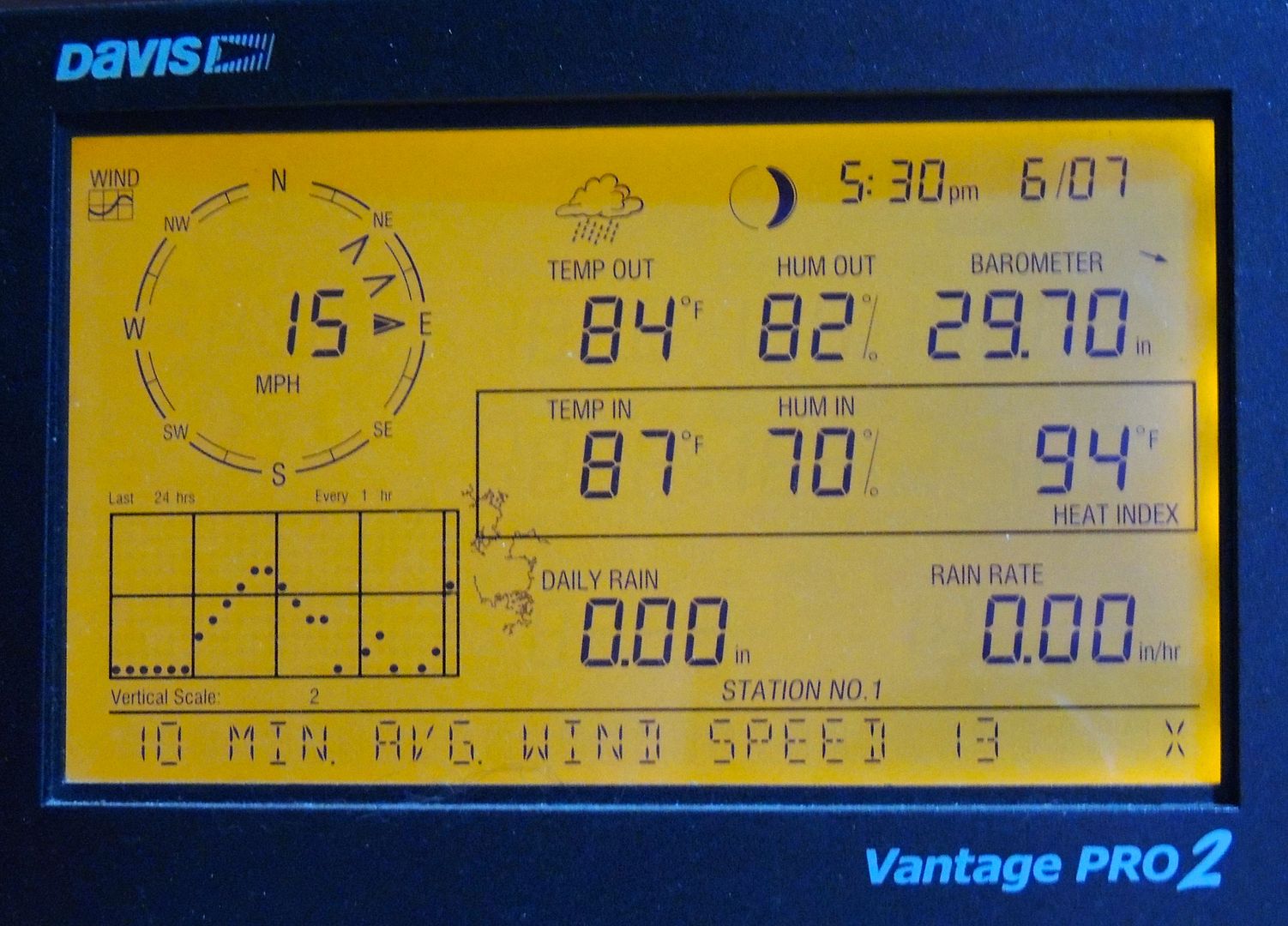
It's very warm outside at 5:30am. The wind has picked up but nothing too bad - just windy and a little gusty now and then. No rain yet in Todos Santos.

[Edited on 6-7-2015 by Katiejay99]

Hook - 6-7-2015 at 04:39 AM

Any webcams in Todos Santos, facing seaward?

What about in Puerto San Carlos?


[Edited on 6-7-2015 by Hook]

Mula - 6-7-2015 at 05:08 AM

No web cams in Puerto San Carlos or Lopez Mateos or San Juanico.

Hook - 6-7-2015 at 05:40 AM

Then, you'll have to be our WX correspondent, Edwina R. Murrow, Mula.

Mula - 6-7-2015 at 06:05 AM

Am leaving San Nicolas this morning. Going to Lopez Mateos to ride out
Blanca.

Will give reports if my Hughesnet hold up.

Will be back in San Nicolas the end of the week after Blanca leaves!

cj5orion - 6-7-2015 at 06:41 AM

webcams ?

https://www.windyty.com/spot/ad/MMSL/22.95/-109.94?2015-06-0...

Hook - 6-7-2015 at 07:10 AM

Well, as Cabo webcams go, I like this one. VERY realtime!!!

http://www.cabovillasbeachresort.com/live-webcam.htm

SFandH - 6-7-2015 at 07:14 AM

Quote: Originally posted by cj5orion  
webcams ?

https://www.windyty.com/spot/ad/MMSL/22.95/-109.94?2015-06-0...


Another great website for visualizing the weather. Thanks!

Katiejay99 - 6-7-2015 at 08:00 AM

We lost electricity from 6:30 until about 10 minutes ago. Not sure why because there really is very little wind. Lots of clouds whipping by

pacificobob - 6-7-2015 at 08:08 AM

Quote: Originally posted by Katiejay99  
We lost electricity from 6:30 until about 10 minutes ago. Not sure why because there really is very little wind. Lots of clouds whipping by


katie, thanks for your updates. there is no substitute for first hand observations. bob

SFandH - 6-7-2015 at 08:11 AM

Katiejay, where are you in TS? North? South? In town?

shari - 6-7-2015 at 08:28 AM

good idea to get out of the arroyos for a few days! Thinking of you all in harms way although sure looks like things arent too bad this morning so far...later today will tell the tale of how Blanca will track...long night ahead around Mag Bay I imagine!

I look forward to onsite reports today as long as we have internet which probably isnt for much longer as it gets unusable in the daytime lately.

Dark skies to the south of us, swell building but still partly sunny and calm here in Asuncion.

David K - 6-7-2015 at 08:31 AM

Quote: Originally posted by Hook  
Well, as Cabo webcams go, I like this one. VERY realtime!!!

http://www.cabovillasbeachresort.com/live-webcam.htm


ROUGH indeed! Thanks Hook!

Katiejay99 - 6-7-2015 at 08:40 AM

I am in Las Tunas (North of town) at a place known as CalyCanto - just a block away from the beach with 360 degree view.

SFandH - 6-7-2015 at 09:22 AM

Video posted to youtube around 9 AM - Cabo beach.


The following link will show videos posted within the past hour. Use the filters button to change time period.

https://www.youtube.com/results?search_query=hurricane+blanc...


[Edited on 6-7-2015 by SFandH]

Katiejay99 - 6-7-2015 at 09:32 AM

It just started sprinkling here. Completely overcast and the ocean looks quite "angry". I can't get down to it right now because I put a row of sandbags across the entry and can't get out. The wind is refreshing and gusty.

Live Web Cams

windgrrl - 6-7-2015 at 09:34 AM

http://www.cabovillas.com/webcams.asp

Blanca please be kind to our friends.

Cat 1; 90mph sustained winds

BajaNomad - 6-7-2015 at 09:52 AM

HURRICANE BLANCA ADVISORY NUMBER 28
900 AM MDT SUN JUN 07 2015

...TROPICAL STORM CONDITIONS EXPECTED OVER PORTIONS OF BAJA
CALIFORNIA SUR SOON...


SUMMARY OF 900 AM MDT...1500 UTC...INFORMATION
----------------------------------------------
LOCATION...20.5N 111.0W
ABOUT 180 MI...290 KM SSW OF CABO SAN LUCAS MEXICO
ABOUT 310 MI...495 KM SSE OF CABO SAN LAZARO MEXICO
MAXIMUM SUSTAINED WINDS...90 MPH...150 KM/H
PRESENT MOVEMENT...NNW OR 340 DEGREES AT 12 MPH...19 KM/H
MINIMUM CENTRAL PRESSURE...974 MB...28.77 INCHES


DISCUSSION AND 48-HOUR OUTLOOK
------------------------------
At 900 AM MDT (1500 UTC), the center of Hurricane Blanca was located
near latitude 20.5 North, longitude 111.0 West. Blanca is moving
toward the north-northwest near 12 mph (19 km/h) and this general
motion with a slight increase in forward speed is expected over
the next couple of days. On the forecast track, the center of
Blanca will approach the southwest coast of the Baja California
peninsula later today, and move near or along the coast tonight and
Monday.

Maximum sustained winds have decreased near 90 mph (150 km/h) with
higher gusts. Additional weakening is forecast during the next 48
hours, and Blanca is expected to weaken to a tropical storm tonight
before it reaches the southwestern coast of the Baja California
peninsula. Blanca is forecast to weaken to a tropical depression
by Monday evening.

Hurricane force winds extend outward up to 60 miles (95 km) from the
center and tropical storm force winds extend outward up to 195 miles
(315 km).

The estimated minimum central pressure is 974 mb (28.77 inches).


HAZARDS AFFECTING LAND
----------------------
WIND: Tropical storm conditions are expected to first reach the
southern portion of the warning area within a few hours, making
outside preparations difficult or dangerous. Tropical storm
conditions will then spread northward elsewhere within the warning
area later today and Monday. Hurricane conditions are possible in
the hurricane watch area later today and tonight.

RAINFALL: Blanca is expected to produce total rain accumulations of
6 to 10 inches over much of Baja California Sur and the southern
half of the state of Baja California, with possible isolated
maximum amounts of 15 inches over Baja California Sur. These rains
could produce life-threatening flash floods and mud slides.

SURF: Swells generated by Blanca are affecting the coast of
southwestern Mexico, the Pacific coast of the Baja California
peninsula, and the southern Gulf of California. These swells are
likely to cause life-threatening surf and rip current conditions.
For additional information, please consult products from your local
weather office.


HURRICANE BLANCA DISCUSSION NUMBER 28
900 AM MDT SUN JUN 07 2015

The satellite presentation of Blanca continues to deteriorate, with
the eye no longer visible and the coverage and intensity of deep
convection diminishing. The current intensity is set at 80 kt which
is a blend of Dvorak T and Current Intensity numbers. An Air Force
Hurricane Hunter aircraft should provide a good estimate of the
intensity in a few hours. Under the influence of progressively
cooler sea surface temperatures, southerly vertical shear, and the
terrain of the Baja California peninsula, the cyclone should
continue to weaken quickly. The official intensity forecast is
close to the intensity model consensus and calls for the system to
weaken to a tropical storm within 12 to 24 hours. Blanca will
likely degenerate to a remnant low within a couple of days.

The initial motion estimate, 340/10 kt, is about the same as in the
previous advisory. Blanca should continue to move along the western
periphery of a mid- to low-level ridge until dissipation. The
official track forecast is very similar to the previous one and
also very close to the dynamical model consensus.

Moisture associated with the remnants of Blanca is expected to
affect portions of the southwestern United States later this week.

FORECAST POSITIONS AND MAX WINDS

INIT 07/1500Z 20.5N 111.0W 80 KT 90 MPH
12H 08/0000Z 22.2N 111.5W 65 KT 75 MPH
24H 08/1200Z 24.5N 112.3W 45 KT 50 MPH
36H 09/0000Z 26.7N 113.4W 30 KT 35 MPH
48H 09/1200Z 28.7N 114.5W 25 KT 30 MPH...POST-TROP/REMNT LOW
72H 10/1200Z...DISSIPATED


http://www.nhc.noaa.gov/?epac

20150607-945a.jpg - 95kB

Zola - 6-7-2015 at 09:58 AM

Does anyone know by when the rains will likely reach San Juanico? We are trying to decide right now whether we should stay put or leave immediately. Thanks.

David K - 6-7-2015 at 10:05 AM

The windy web site posted by CJ above shows it right off of Scorpion Bay tomorrow (Monday) mid to late morning... Take a look for yourself and note the timeline at the bottom of the map. Leave how, by plane, yes... by car which direction? North being best, but it will be right behind you all the way to Gonzaga Bay.

Zola - 6-7-2015 at 10:08 AM

We would leave by car right now to take the north route. My concern is that the rain may damage the roads to the north and the south, and now it appears that another system is forming off the coast of Central America. If we leave now by the north can we make it without getting caught in the storm?

David K - 6-7-2015 at 10:14 AM

I don't know what kind of driver you are or vehicle you are in... If you know the road to San Ignacio well, then you know how long it will take you to get there. If you break down, and need to sleep in your car, the arroyos will be flowing and you could be stuck for some time. I would find out if anyone else waited to the last minute and travel together.

After the hurricane passes, you would need to take the paved road out via Loreto... and even it could be closed for a day with landslides and washed out bridges, etc.

Good luck!

bajabuddha - 6-7-2015 at 10:25 AM

Zola, I think if you left now (as in within the next hour) you have a possibility of outrunning Blanca. Two variables; how fast you drive, and how fast everyone else is driving that also waited until the last minute to outrun the storm. If you stay, plan on being there a while. It's going to track right up the peninsula, and will probably take out several sections of Hwy 1. According to news reports the Gov't has put in a bunch of agencies (Army, Marines, Power Co. etc.) to facilitate repairs, but it's still going to be a mess.

I bet you wait 'till Dec. 24th to do your xmas shopping too, huh! ;)

Good luck and be safe, whichever you choose. There are plenty of maps on the last 2 pages to tell you the time-frames of what to expect. I'd be concerned of northbound traffic myself.

Zola - 6-7-2015 at 10:26 AM

That makes my decision for me. We planned to be here for the summer.

Even though I know the north road by heart and have a trusty car for the purpose, if they can clear the south road in short order, then we can leave by the south if we need to at a later date. We have our home here. We love Southern Baja.

Zola - 6-7-2015 at 10:39 AM

What was not in our plans was having a full-scale hurricane season that would start on June 1. I hope that the next few storms go out far to the west of Baja, which is what I thought they were supposed to do until mid-August at the earliest! There is another system forming right now, with a 60% chance of becoming a tropical system in the next 5 days...

This is our first summer as residents here.

rufflife - 6-7-2015 at 10:55 AM

There are lots of record cold, record rains, record... going on this year. Maybe Baja felt left out? Maybe she doesn't have a calendar? ;)

While the hurricanes usually hold off until later in the season, the weather in Baja has been setting the stage for an earlier beginning to the storms and the hurricane season (based on the calendar) has begun. Anything can happen.

San Juanico is an amazing place to have to spend time. :) I do applaud your decision to not drive north at this point. It started to rain this morning at San Ignacio Lagoon. Not hard, but no telling what the road looks like right now....and you do not want to get stuck on that road with lots of rain coming!
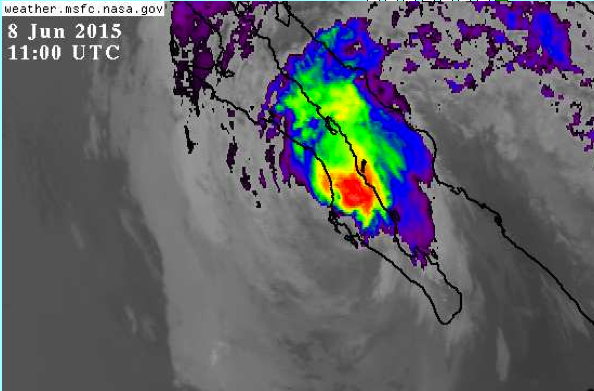
bajalinda - 6-7-2015 at 11:05 AM

Sunday noon

Steady wind from the east here at La Aguja. It started getting windy a couple of hours ago. No rain yet. Surf is building.

High tide will happen in an hour or so and again in the middle of the night. The good news is that it's not a really "high" high tide.

First big wind gust right now.


BajaNomad - 6-7-2015 at 11:21 AM


Continued weakening; sustained winds of 80mph currently.

BajaNomad - 6-7-2015 at 11:32 AM

HURRICANE BLANCA INTERMEDIATE ADVISORY NUMBER 28A
1200 PM MDT SUN JUN 07 2015

...BLANCA CONTINUES TO WEAKEN...


SUMMARY OF 1200 PM MDT...1800 UTC...INFORMATION
-----------------------------------------------
LOCATION...20.9N 110.9W
ABOUT 150 MI...245 KM SSW OF CABO SAN LUCAS MEXICO
ABOUT 330 MI...455 KM SSE OF CABO SAN LAZARO MEXICO
MAXIMUM SUSTAINED WINDS...80 MPH...130 KM/H
PRESENT MOVEMENT...NNW OR 340 DEGREES AT 9 MPH...15 KM/H
MINIMUM CENTRAL PRESSURE...979 MB...28.91 INCHES


DISCUSSION AND 48-HOUR OUTLOOK
------------------------------
At 1200 PM MDT (1800 UTC), the center of Hurricane Blanca was
located near latitude 20.9 North, longitude 110.9 West. Blanca is
moving toward the north-northwest near 9 mph (15 km/h) and this
general motion is expected to continue for the next couple of
days. On the forecast track, the center of Blanca will approach the
southwest coast of the Baja California peninsula later today, and
move near or along the coast tonight and Monday.

Maximum sustained winds have decreased near 80 mph (130 km/h) with
higher gusts. Additional weakening is forecast during the next 48
hours, and Blanca is expected to weaken to a tropical storm tonight
before it reaches the southwestern coast of the Baja California
peninsula. Blanca is forecast to weaken to a tropical depression
by Monday evening.

Hurricane force winds extend outward up to 60 miles (95 km) from the
center and tropical storm force winds extend outward up to 195 miles
(315 km).

The minimum central pressure estimated from Air Force Hurricane
Hunter data is 979 mb (28.91 inches).


Zola - 6-7-2015 at 11:48 AM

It is calm, hazy, a little muggy, and with a mild breeze here in San Juanico. It is very pleasant overall at the moment. All of the campers have left town.

capitolkat - 6-7-2015 at 12:00 PM

IN La Paz--in the last hour winds have picked up from the SE, estimate at 20/30 mph with higher gusts. No rain yet but clouds are building to the north. Expect the wind to shift as the storm moves NW. We are in Centenario which is on the West side of La paz just west of the highway.

El Jefe - 6-7-2015 at 12:20 PM

Just started to rain on near east cape. Wind from the east at 20-30 mph. The sea looks angry. Here it comes.

Bob and Susan - 6-7-2015 at 12:31 PM

it was cloudy this morning but now it's clear and sunny here on the bay at mulege...all out "stuff" is put away...

stress.jpg - 97kB

Katiejay99 - 6-7-2015 at 12:43 PM

The sprinkles came and went and came and went so now I'm just waiting for them to come again. No real rain yet. Gusty winds!

El Jefe - 6-7-2015 at 12:59 PM

Yep, I jumped the gun. We had a sprinkle and that was all. Would it just do what it's gonna do already? Getting some solid wind gusts now.

capitolkat - 6-7-2015 at 01:13 PM

Wind has really picked up here in La Paz, estimate 30/40 and higher gusts. I usually have great visibility and can clearly see Isla Espiritu Santos, maybe 20 miles away from Centenario- now huge dust cloud limits visibility to about 1/2 mile, can't see city and lower houses in my neighborhood. The SOC is out there somewhere but can't see any of it. Humidity is rolling in but no rain yet.

Hook - 6-7-2015 at 02:00 PM

Current Wundermap with the hurricane/typhoon box checked shows Blanca down to tropical storm status. Looking very unorganized.

I think there should be an NHC update any minute.

The update is out. Officially down to TS status. And it hasnt made land yet.

[Edited on 6-7-2015 by Hook]

Hook - 6-7-2015 at 02:15 PM

TS Blanca

bajabuddha - 6-7-2015 at 02:21 PM

http://www.eebmike.com/

Best shots so far.

Katiejay99 - 6-7-2015 at 03:26 PM

Other than a few sprinkles here and there, no rain. Gusty on and off wind - not enough to pick anything up and toss it and certainly not enough to cause any damage. I hear electricity is out in Pescadero but we have it here in Todos Santos.

Continued weakening; sustained winds of 70mph currently.

BajaNomad - 6-7-2015 at 03:34 PM

TROPICAL STORM BLANCA ADVISORY NUMBER 29
300 PM MDT SUN JUN 07 2015

...BLANCA WEAKENS TO A TROPICAL STORM...


SUMMARY OF 300 PM MDT...2100 UTC...INFORMATION
----------------------------------------------
LOCATION...21.3N 111.0W
ABOUT 130 MI...210 KM SSW OF CABO SAN LUCAS MEXICO
ABOUT 255 MI...410 KM SSE OF CABO SAN LAZARO MEXICO
MAXIMUM SUSTAINED WINDS...70 MPH...110 KM/H
PRESENT MOVEMENT...NNW OR 345 DEGREES AT 9 MPH...15 KM/H
MINIMUM CENTRAL PRESSURE...980 MB...28.94 INCHES


DISCUSSION AND 48-HOUR OUTLOOK
------------------------------
At 300 PM MDT (2100 UTC), the center of Tropical Storm Blanca was
located near latitude 21.3 North, longitude 111.0 West. Blanca is
moving toward the north-northwest near 9 mph (15 km/h), and this
general motion is expected to continue for the next couple of
days. On the forecast track, the center of Blanca will approach the
southwest coast of the Baja California peninsula later today, and
move near or along the coast tonight and Monday.

Maximum sustained winds have decreased to 70 mph (110 km/h) with
higher gusts. Additional weakening is forecast during the next 48
hours, and Blanca is forecast to weaken to a tropical depression
by Monday afternoon or evening.

Tropical storm force winds extend outward up to 175 miles (280 km)
from the center. A sustained wind of 46 mph (74 km/h) was reported
at the Cabo San Lucas International Airport about two hours ago.

The minimum central pressure estimated from Air Force Hurricane
Hunter data is 980 mb (28.94 inches).


HAZARDS AFFECTING LAND
----------------------
WIND: Tropical storm conditions are occurring over the southern
portion of the warning area. Tropical storm conditions should
spread northward elsewhere within the warning area later today and
Monday.

RAINFALL: Blanca is expected to produce total rain accumulations of
3 to 5 inches over much of Baja California Sur and the southern half
of the state of Baja California, with isolated maximum amounts of 10
inches over Baja California Sur. These rains could produce
life-threatening flash floods and mud slides. Rainfall associated
with Blanca may begin to affect portions of the southwestern United
States on Tuesday.

SURF: Swells generated by Blanca are affecting the coast of
southwestern Mexico, the Pacific coast of the Baja California
peninsula, and the southern Gulf of California. These swells are
likely to cause life-threatening surf and rip currents. For
additional information, please consult products from your local
weather office.


TROPICAL STORM BLANCA DISCUSSION NUMBER 29
300 PM MDT SUN JUN 07 2015

Observations from an Air Force Reserve Unit reconnaissance aircraft
indicate that Blanca has weakened quickly today. The peak
SFMR-observed surface winds were 57 kt over the northeast quadrant.
On this basis, Blanca is being downgraded to a 60-kt tropical storm
for this advisory. Continued weakening is likely as the system will
be moving over progressively cooler waters with fairly strong
southerly to southwesterly shear, and interacting with the terrain
of the Baja California peninsula. The official wind speed forecast
is in good agreement with the latest intensity model consensus.
Blanca should degenerate into a remnant low in 24 to 36 hours.

The motion, 345/8 kt, is a bit slower than previous estimates.
Otherwise there is little change to the steering scenario. Blanca
or its remnant should continue to move along the western periphery
of a mid- to low-level ridge until dissipation. The official track
forecast is a blend of the ECMWF and medium-depth BAM tracks to
account for the expected shallowness of the cyclone, and is a little
slower than the previous NHC forecast.

Moisture associated with Blanca is expected to affect portions of
the southwestern United States in a couple of days.

FORECAST POSITIONS AND MAX WINDS

INIT 07/2100Z 21.3N 111.0W 60 KT 70 MPH
12H 08/0600Z 23.0N 111.4W 50 KT 60 MPH
24H 08/1800Z 25.3N 112.4W 35 KT 40 MPH
36H 09/0600Z 27.5N 113.4W 25 KT 30 MPH...POST-TROP/REMNT LOW
48H 09/1800Z 30.0N 113.6W 20 KT 25 MPH...POST-TROP/REMNT LOW
72H 10/1800Z...DISSIPATED


http://www.nhc.noaa.gov/?epac

BajaNomad - 6-7-2015 at 03:42 PM


20150607-341p.jpg - 114kB

Mula - 6-7-2015 at 04:41 PM

Hot, strong wind gusts just came in to Lopez Mateos.
The start of maybe a long night here.

BajaNomad - 6-7-2015 at 04:49 PM


BajaNomad - 6-7-2015 at 04:51 PM


Russ - 6-7-2015 at 04:54 PM

I'm looking at this site I got here. https://www.windyty.com/?snow,27.455,-108.369,7
Click on Cloud,Rain then look for the small circles and click them for local cam shots and info. very cool

BajaNomad - 6-7-2015 at 05:00 PM


wessongroup - 6-7-2015 at 05:01 PM

:):)

BajaNomad - 6-7-2015 at 05:02 PM

https://www.youtube.com/user/sshanky/videos

https://www.youtube.com/channel/UClMyKdJ7CEtR5bT1VTzKpVQ/vid...

Happy Hour?

SFandH - 6-7-2015 at 05:10 PM

INGREDIENTS IN THE THE HURRICANE c-ckTAIL

2 oz White rum
2 oz Dark rum
1 oz Lime juice
1 oz Orange juice
2 oz Passion fruit juice
.5 oz Simple syrup
.5 oz Grenadine

-----------------------------------

Don't mean to make light of a serious situation. I'm glad to see the storm is falling apart and hope it fizzles out completely.

Bob and Susan - 6-7-2015 at 05:14 PM

still nothing here in mulege except
it's 90f and HUMID!!!

its not supposed to rain until 12pm
and NO ONE wants to be unprepared at night


T. S. Blanca

CaboSur - 6-7-2015 at 05:28 PM

T. S. Blanca San Jose del Cabo 6:00Pm

Here in San Jose the winds seem to have peaked at about 40-50 mph. Forecasted 4-6 inches of rain , so far we've had very little. Appears the worst is passing by.

Mula - 6-7-2015 at 05:40 PM

Noisy, hot = 90 degree, strong steady wind here in Lopez.

shari - 6-7-2015 at 06:19 PM

I actually was hoping a new local update thread like this would be started. Partly cloudy, calm, swell maybe 8' in Bahia Asuncion and waiting to see what tomorrow brings.

BajaNomad - 6-7-2015 at 06:50 PM

TROPICAL STORM BLANCA INTERMEDIATE ADVISORY NUMBER 29A
600 PM MDT SUN JUN 07 2015

...TROPICAL STORM CONDITIONS OCCURRING OVER EXTREME SOUTHERN BAJA
CALIFORNIA SUR...


SUMMARY OF 600 PM MDT...0000 UTC...INFORMATION
----------------------------------------------
LOCATION...21.9N 111.1W
ABOUT 100 MI...160 KM SW OF CABO SAN LUCAS MEXICO
ABOUT 215 MI...345 KM SSE OF CABO SAN LAZARO MEXICO
MAXIMUM SUSTAINED WINDS...70 MPH...110 KM/H
PRESENT MOVEMENT...NNW OR 345 DEGREES AT 10 MPH...17 KM/H
MINIMUM CENTRAL PRESSURE...980 MB...28.94 INCHES


DISCUSSION AND 48-HOUR OUTLOOK
------------------------------
At 600 PM MDT (0000 UTC), the center of Tropical Storm Blanca was
located near latitude 21.9 North, longitude 111.1 West. Blanca is
moving toward the north-northwest near 10 mph (17 km/h), and this
general motion is expected to continue for the next couple of
days. On the forecast track, the center of Blanca will approach the
southwest coast of the Baja California peninsula this evening, and
move near or along the coast tonight and Monday.

Maximum sustained winds are near 70 mph (110 km/h) with higher
gusts. Additional weakening is forecast during the next 48 hours,
and Blanca is forecast to weaken to a tropical depression by Monday
afternoon or evening.

Tropical storm force winds extend outward up to 175 miles (280 km)
from the center. During the past few hours, the Cabo San Lucas
International Airport has reported sustained winds of 46 mph (74
km/h) and a gust to 49 mph (80 km/h).


norte - 6-7-2015 at 06:56 PM

lack of interest it seems.

Zola - 6-7-2015 at 08:06 PM

I realized today that it is here where we wish to live, this is how we prefer to live, come what may! (But if a category 4 is ever headed our way, we will evacuate unless we cannot!)

bajalinda - 6-7-2015 at 08:20 PM

So far this has been a wind event here (La Aguja). No rain yet - maybe we'll get some rain overnight. Sheesh - why do these things always seem to arrive at night!

BajaNomad - 6-7-2015 at 09:14 PM

TROPICAL STORM BLANCA ADVISORY NUMBER 30
900 PM MDT SUN JUN 07 2015

...BLANCA CONTINUES TO WEAKEN GRADUALLY...
...TROPICAL STORM CONDITIONS SPREADING NORTHWARD OVER THE SOUTHERN
BAJA CALIFORNIA PENINSULA...


SUMMARY OF 900 PM MDT...0300 UTC...INFORMATION
----------------------------------------------
LOCATION...22.3N 111.2W
ABOUT 95 MI...150 KM WSW OF CABO SAN LUCAS MEXICO
ABOUT 185 MI...300 KM SSE OF CABO SAN LAZARO MEXICO
MAXIMUM SUSTAINED WINDS...65 MPH...100 KM/H
PRESENT MOVEMENT...NNW OR 345 DEGREES AT 10 MPH...17 KM/H
MINIMUM CENTRAL PRESSURE...988 MB...29.18 INCHES


DISCUSSION AND 48-HOUR OUTLOOK
------------------------------
At 900 PM MDT (0300 UTC), the center of Tropical Storm Blanca was
located near latitude 22.3 North, longitude 111.2 West. Blanca is
moving toward the north-northwest near 10 mph (17 km/h), and this
general motion is expected to continue during the next day or two.
On the forecast track, the center of Blanca will approach the
southwestern coast of the Baja California peninsula overnight,
and move near or over the peninsula Monday through Tuesday.

Maximum sustained winds have decreased to near 65 mph (100 km/h),
with higher gusts. Additional weakening is forecast, and Blanca is
expected to become to a tropical depression by Monday afternoon or
evening. Blanca will likely dissipate near or over northern
portions of the Baja California peninsula by late Tuesday.

Tropical storm force winds extend outward up to 150 miles (240 km)
from the center.

The estimated minimum central pressure is 988 mb (29.18 inches).


TROPICAL STORM BLANCA DISCUSSION NUMBER 30
900 PM MDT SUN JUN 07 2015

Vertical shear and cold water are taking their toll on Blanca,
with recent microwave data indicating that the low-level center is
separating from the mid-level rotation noted in geostationary
satellite images. Maximum winds are now estimated to be 55 kt
based on a blend of Dvorak estimates of T3.5/4.5 from TAFB and
T3.0/4.0 from SAB. Continued shear, even colder water, and the
terrain of the Baja California peninsula should lead to further
weakening, and Blanca is forecast to become a tropical depression
within 24 hours and dissipate by 48 hours. The NHC intensity
forecast is very close to the intensity model consensus.

The initial motion is 345/9 kt. Blanca is expected to continue
moving north-northwestward between a mid-level high centered over
northern Mexico and a deep-layer low located southwest of
California. As has been the case for days, there are still
some speed differences among the models, with the GFS being one of
the faster models. The updated NHC track forecast is very close to
the ECMWF and the multi-model consensus (TVCE), which are
essentially identical through 24 hours.


20150607-914p.jpg - 92kB

BajaNomad - 6-7-2015 at 09:32 PM

Quote: Originally posted by shari  
I actually was hoping a new local update thread like this would be started.


No problem having separate threads that are specific to certain local areas. None of the merged threads have yet indicated an intention of being such - at least by my observation... fyi.

:)

Hook - 6-8-2015 at 03:55 AM

Looks like it has finally moved onto land. Must be dumping serious amounts of rain in the Gigantas.

Hello Loreto, what's up????? Looks like serious bands of cumulus clouds should be reaching you?

Ciudad Insurgentes looks to be very near the former center of the disturbance.

CJ - 6-8-2015 at 04:32 AM

Here in loreto we have wind gusting to probably around 40 mph. And light rain. Started sometime around four o'clock. So far so good :cool:

Russ - 6-8-2015 at 04:35 AM

Wind woke me at 5am. No rain yet. 24mph gust but average wind not bad..... Coffee perking .......


[Edited on 6-8-2015 by Russ]

willyAirstream - 6-8-2015 at 05:43 AM

Heavy wind and rain, started at 6am

rufflife - 6-8-2015 at 05:45 AM

Quote: Originally posted by Zola  
I realized today that it is here where we wish to live, this is how we prefer to live, come what may! (But if a category 4 is ever headed our way, we will evacuate unless we cannot!)


It's a great feeling when you find that part of Baja that feels like home, isn't it :) Congrats!

With each storm you will get a better feel for what your area can handle (some areas can't handle wind, some areas can't support a lot of rain), as well as when you should leave. When you do chose to leave make sure it is early enough to get to a safe place. You do not want to be stuck out with no cell reception and in an area where help will not be able to get to you.

Make sure to have enough emergency supplies on hand throughout the summer and fall - it doesn't take a hurricane to wipe out roads in your neck of the woods. You just need a bit of water to impact the roads. You'll get a feel for it all and it will soon become second nature.:)

Zola - 6-8-2015 at 05:52 AM

Here in San Juanico we have had gentle, steady, persistent rains that began during the wee hours (perhaps shortly after midnight) and have not stopped since. There has been no wind. The rainwaters are gently accumulating. Before the rains, the humidity became very intense, but now it is more comfortable again. So far it all seems like an unremarkable, salutary rainstorm, except that it cannot be good for the roads.... It will likely look very beautiful after the system passes and the sun returns. I hope we are not cut off from the world for too long, and that we do not get storm winds later in the day.

Rufflife, thanks for the comments above:)

Russ - 6-8-2015 at 06:02 AM

wind 22mph average now, raining but not hard, surf 3' wind blown, expecting storm surge a little later. Meany down the beach with the same weather machine as I reporting average 35mph with a 39 gust
 Pages:  1  2