BajaNomad

Canyons

 Pages:  1  2

David K - 12-7-2021 at 04:47 PM

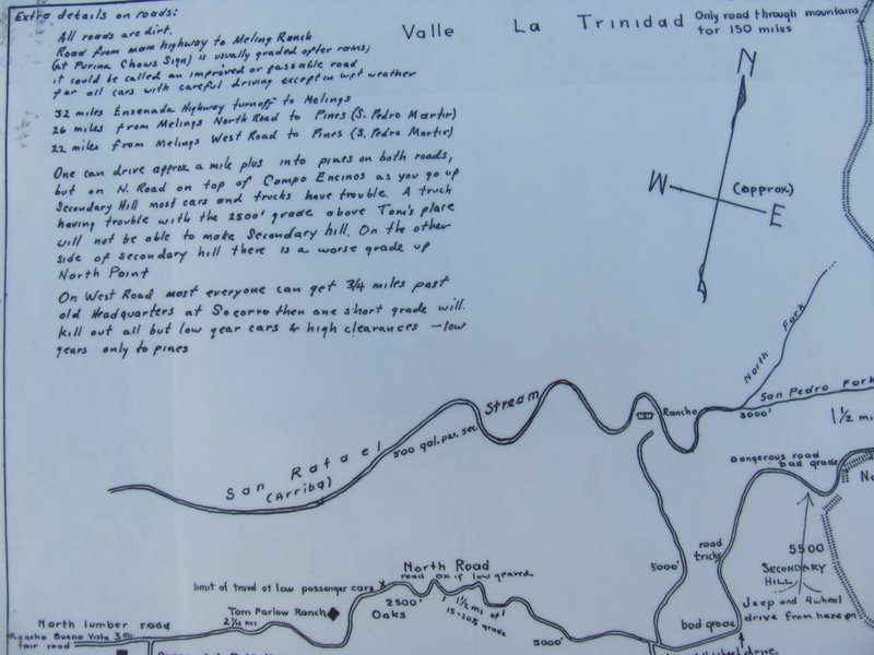
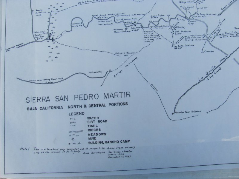
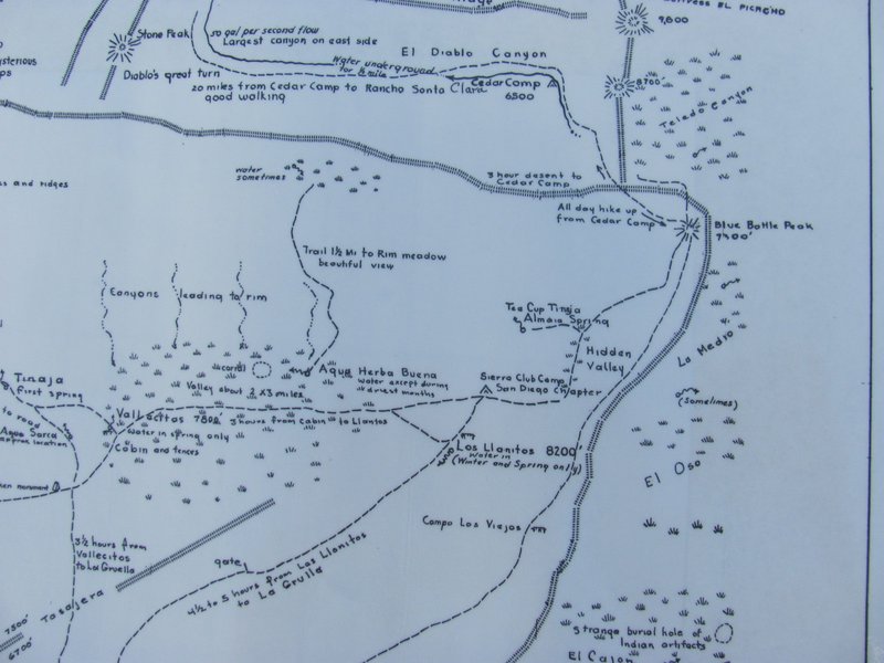
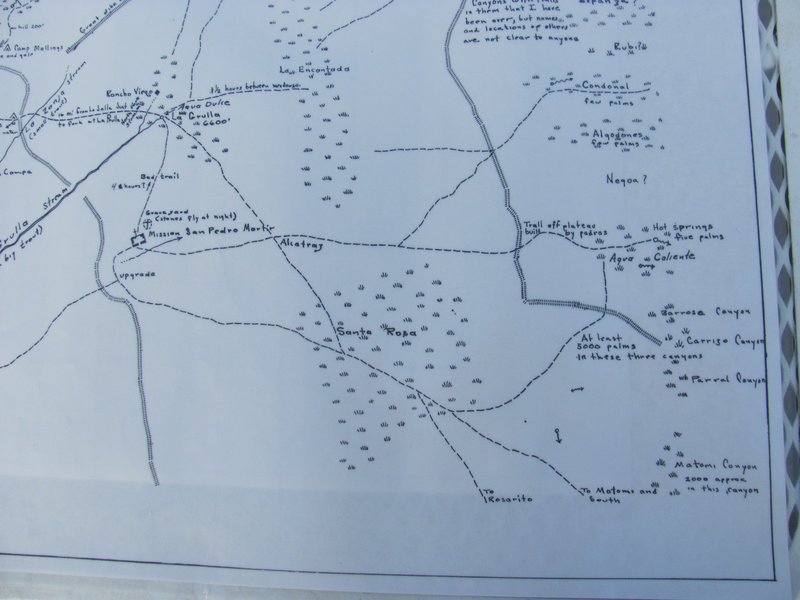
So far, we have four images. A small area of the upper center, and some edges, are missing.

Upper Left:


Lower Left:


Upper Right:


Lower Right:

Barry A. - 12-7-2021 at 05:58 PM

Interesting, and disappointing (Bud Bernhard maps). What showed up on my digital Canon Camera screen is not quite what the camera actually captured, and I also may have made a mistake (but of course very unlikely). It is very hard to see what is on the camera screen in bright light situations. I will think about this and see if I can come up with more excuses!!
Barry

David K - 12-7-2021 at 06:16 PM

Quote: Originally posted by Barry A.  
Interesting, and disappointing (Bud Bernhard maps). What showed up on my digital Canon Camera screen is not quite what the camera actually captured, and I also may have made a mistake (but of course very unlikely). It is very hard to see what is on the camera screen in bright light situations. I will think about this and see if I can come up with more excuses!!
Barry


The wonderful thing is that you preserved these maps from 1962-63!!! Heck, if it was in Delta (Animal) House, it would have gone up in flames!!!
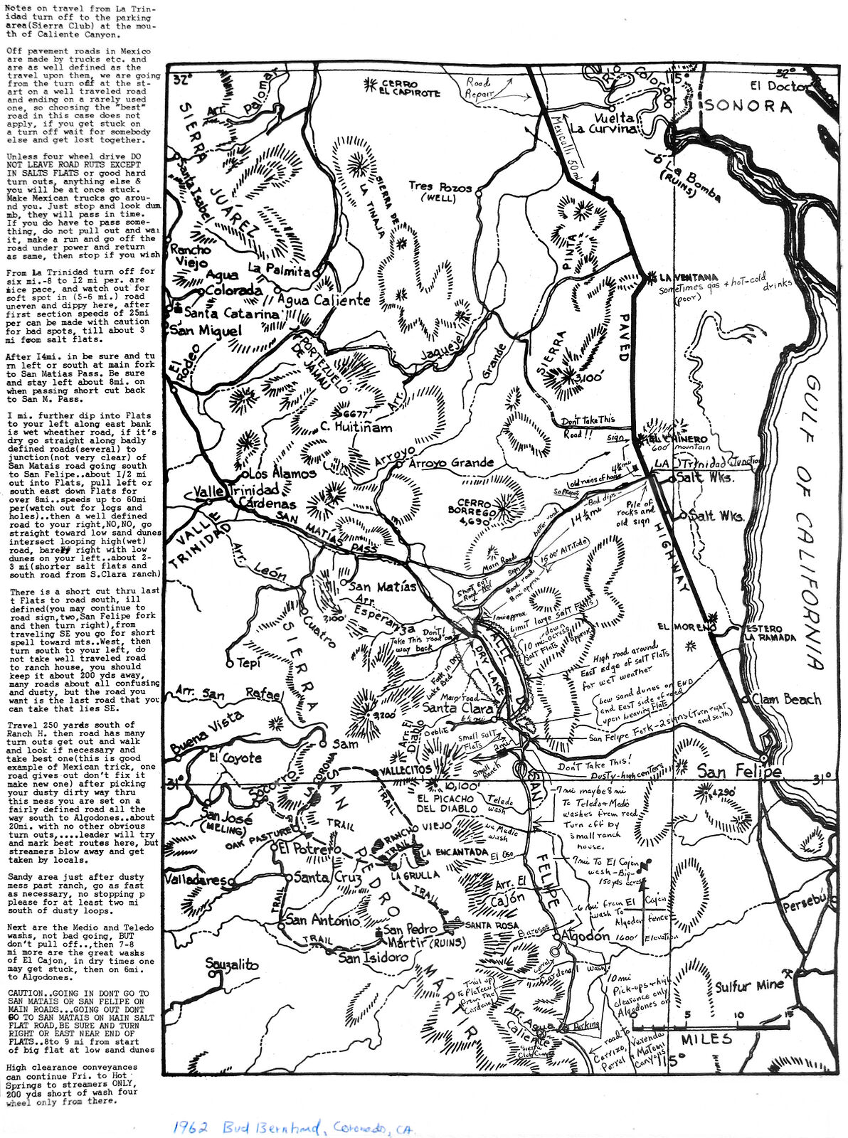
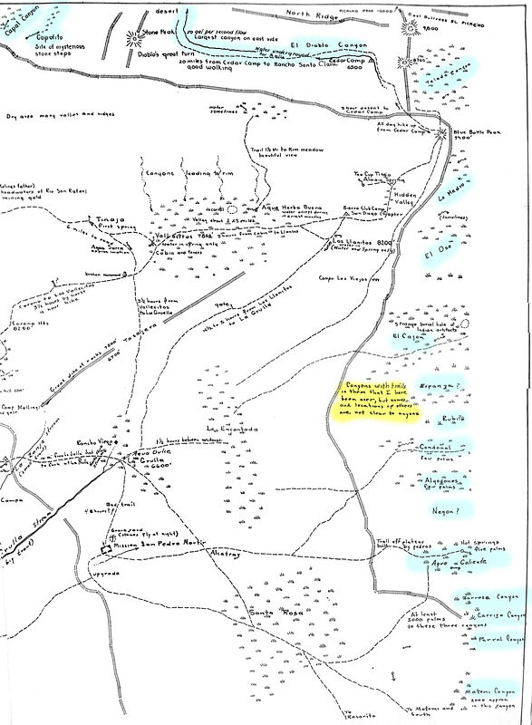
Here is the canyon notes and map, enhanced:


4x4abc - 12-7-2021 at 06:27 PM

where is geoffff?
these images only hurt my eyes

David K - 12-7-2021 at 06:42 PM

Refresh your page, Harald ... I posted Geoffff's enhancement above.

David K - 12-7-2021 at 06:46 PM

I deleted the first postings of maps that Geoffff fix. When he has the Sierra map enhanced, I will delete the above versions.

geoffff - 12-7-2021 at 08:33 PM

thanks for posting, David!

Here is a super-size version of the above map for downloading, printing.

1962--Bud-Bernhard-Map--Valle-Chico--Baja-California.jpg


geoffff - 12-7-2021 at 08:34 PM

Quote: Originally posted by Barry A.  
I was alerted via e-mail this morning to this BAJA NOMAD "thread" (Canyons) by Dr. Vince Flynn of Coronado, a Coronado high-school classmate of mine and good friend. I knew Edward "Bud" Bernhard pretty well back in the '50's and '60's, and beyond, and went on several of his trips into Northern Baja. I believe I have a copy of the Map referred to by Geoff, and other's above. I also have a copy of the "Dec. 12,1963" freehand-map prepared by Bud Bernhard at the request of Al Schmitz of the Sierra Club dealing with that portion of the San Pedro Martir plateau and west-facing foot hills just west of Picacho del Diablo and east of Melings Ranch. It also deals with the some of the canyons and their names on the eastern slope of the San Pedro Martir just south of Picacho del Diablo and north of Matomi Canyon.


Thank you Barry!!!

geoffff - 12-7-2021 at 08:54 PM

Back to Canyon identification -- I am not sure Bud's map has enough precision provide any new insights, but what it shows does seem to approximately agree with what we have so far:


David K - 12-8-2021 at 09:31 AM

On the right edge of the other map (1963 Sierra San Pedro Mártir) are many canyon notes or names.

John Harper - 12-8-2021 at 09:43 AM

I see noted by La Grulla stream is "big trout' where it goes to San Antonio. And above that is La Zanja denoted with "small trout."


John

[Edited on 12-8-2021 by John Harper]

4x4abc - 12-8-2021 at 12:11 PM

can we get San Pedro Martir as a big scan as well? Please!

David K - 12-8-2021 at 12:16 PM

Yes, Harald... Stay tuned. Barry A needs to get us some more photos of it to fill in. Then, geoffff can make an enhanced image of it, too.

4x4abc - 12-8-2021 at 12:26 PM

we have all those wonderful new tools
high quality and everything
if only the nerds creating them could make them easier to operate
much easier
if you have app A, it wont talk to app B. But it works with C - only C can't be exported.
It is a big effing mess.

spent the better part of an hour today to install a beta navigation app on my iPhone
only a video conference with the app creators made it possible in the end
it was not smooth
it was not satisfying
to smooth things over, they told me I have to do this only once
then everything would work fine
right
just wait for the next update.

Baja Bucko (Teddi) remembers Bud Bernhard:

David K - 12-8-2021 at 06:08 PM

Quote: Originally posted by David K  
Howard Gulick (Lower California Guidebook) photographed Bud in the Sierra Cucapá, on Feb 12, 1961:


Bud Bernhard 1961.jpg - 266kB


Baja Bucko posted this on my Facebook page where I also shared Bud's photo. She said I could share it here, too:

My first San Pedro Martir backpack trip back in 1973 was following Bud for Two weeks-just a hippie chick and Bud preparing for a Sierra Club pack trip. I drove down w him from PB in his old International Harvester truck and on the way into San Telmo he let me drive. Of course I did not know how to drive and so he got me started and accused me of actually purposely aiming for the deep potholes. It was an incredible experience and changed my life.

He’d pack along cans of slim fast -type drinks for food and all over that range these cans of Bud’s are buried. I had no idea who he was when he picked me up and by the end of the entire adventure we called him the Batman of Baja! When the Sierra Club folks came a few days later for their trip, I was privileged to meet the late great Louise Werner of desert explorer fame. She and Bud were old old friends. She was 75 years old and always hiking at the front of the group. What an inspiration.

At the end of that adventure Bud then was part of the group to get the San Diego Dj up Picacho and I spent the nights on Blue Bottle. Every year after when I was in San Diego shy old Bud and I would meet for dinner and he’d always remind me to be safe as I was always headed south solo. He was a gentle soul and yes, famous on Coronado for his masonry work. He was Bertie Meling’s adopted son. And the stories he told of rescues and explorations on that mountain range.

It was sad at the end, dying alone and losing everything. He was A very private man and I will always have him in my heart.


geoffff - 12-8-2021 at 07:08 PM

Quote: Originally posted by 4x4abc  
can we get San Pedro Martir as a big scan as well? Please!


Like David said, we are still waiting for some higher-resolution images -- but the east half of the map -- with the canyons highlighted -- is mostly complete.

Here is a teaser crop of the Bud's 1963 map, with those canyons. Click to enlarge:

19631212--Bud-Bernhard-Map--Sierra-San-Petdro-Martir--Canyons-on-East-Side-of-Map--Crop.jpg


I'll post the full map without any highlighting when it's done!

PaulW - 12-8-2021 at 10:22 PM

What we do see is a different version of Esperanza with two forked canyon different than what is depicted on all the versions from INEGI.
And INEGI shows other canyons north from INEGI Esperanza that do have a two-fork configuration. I wonder if Bud hiked Esperanza in order to make his map. Or is there a still older source he used?

And
Based on my knowledge of the old road heading diagonal to the north to Hwy 3 it appears that Bud's Esperanza is one of the large north canyons with two forks and not the one south by Diablo canyon that we all call Esperanza.

4x4abc - 12-9-2021 at 07:37 AM

1949 map

Screen Shot 2021-12-09 at 7.35.02 AM copy.jpg - 190kB

David K - 12-9-2021 at 10:48 AM

Obituary for Bud (2007): http://www.coronadonewsca.com/obituaries/edward-8220bud-bern...

4x4abc - 12-9-2021 at 11:42 AM

did you notice "Cañon Negro"?

David K - 12-9-2021 at 12:12 PM

Yes, it is on Bud's map, too. The next canyon north of Agua Caliente.
Could it be the Gringa or Rubi of newer maps??

[Edited on 12-9-2021 by David K]

geoffff - 12-12-2021 at 12:06 AM

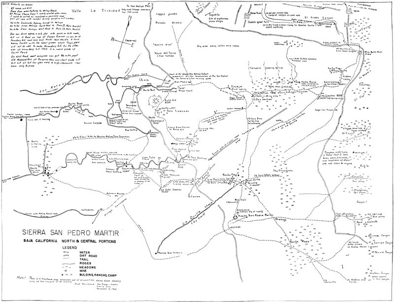
Here is the full image of the 1963 Bud Bernhard map of the Sierra San Pedro Martir area - combined from a series of photographs. Not crisp, but at least it is readable. Click to enlarge to full size:

19631212--Bud-Bernhard-Map--Sierra-San-Pedro-Martir.jpg

Canyons

Barry A. - 12-12-2021 at 04:53 AM

Well done, Geofff!!! and David K... Many thanks. With "clicking" on the map image several times it looks to me like all the info is readable, tho awkward to see the big-picture but doable.

Thanks again.

Barry

David K - 12-12-2021 at 08:55 AM

Excellent... So many cool details, like where the Johnson water flume to Socorro mine begins, Soto cabin, etc.

Thank you very much Geoff... the double click to super enlarge is a great feature to read the notes.

geoffff - 12-12-2021 at 01:51 PM

Quote: Originally posted by 4x4abc  
did you notice "Cañon Negro"?


Yes! I was thinking Negro is what we now call El Cajon, since it is the most significant canyon around, and since Cajon starts just southwest of El Cajón (El Chaparral).

-- Geoff

[Edited on 12-12-2021 by geoffff]

PaulW - 12-12-2021 at 02:48 PM

That canyon now 3 names El Cajon, Arenoso, and Negro


Quote: Originally posted by geoffff  
Quote: Originally posted by 4x4abc  
did you notice "Cañon Negro"?


Yes! I was thinking Negro is what we now call El Cajon, since it is the most significant canyon around, and since Cajon starts just southwest of El Cajón (El Chaparral).

-- Geoff

[Edited on 12-12-2021 by geoffff]

mtgoat666 - 12-12-2021 at 02:56 PM

Bud’s map is a bit (a big bit) distorted, geographically.
I like the humorous and mysterious notes like “stones fly at night” at the mission graveyard and mystery steps at copal cyn. (Copalito)

David K - 12-12-2021 at 02:59 PM

El Cajon is a major canyon system and well-known as also being the route used by the Indians and Dominicans to get to San Felipe Bay... I just don't think there is any confusion on its name.

John Harper - 12-12-2021 at 05:43 PM

Fascinating map, thank you so much. I wonder how accurately the trails align with modern sat photos? Especially the trail mileage. I would assume some of these trails are long disused.

John

[Edited on 12-13-2021 by John Harper]

PaulW - 12-13-2021 at 08:17 AM

Yes I agree, only one name is correct.
And there are other Indian trails across the mountain , like Aqua Caliente, but I cannot find a map of any actual Indian trails. Can anyone point me to a link?
As you know El Cajon headwaters are at the mountain ridge a short distance for the headwaters of Arenoso which is the main branch of El Cajon. So, by inspection of the topo either drainage could be used.
=== ===

Quote: Originally posted by David K  
El Cajon is a major canyon system and well-known as also being the route used by the Indians and Dominicans to get to San Felipe Bay... I just don't think there is any confusion on its name.

geoffff - 12-13-2021 at 11:34 AM


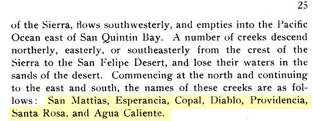
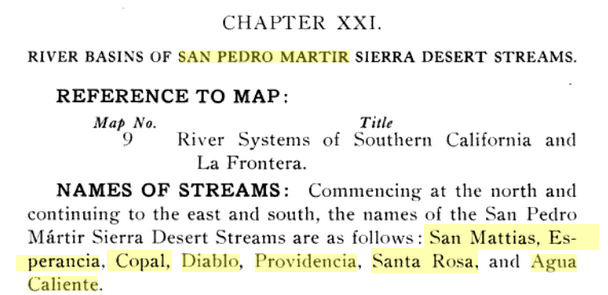
I did some searching on Google Books and turned up some old references to these canyons.

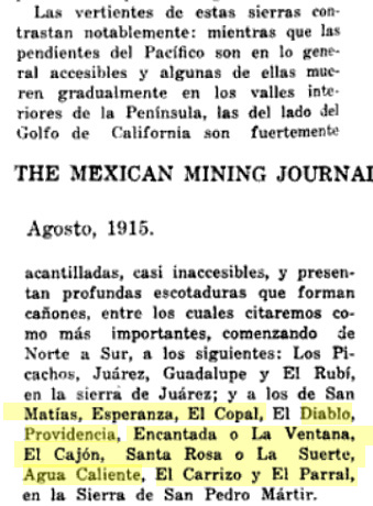
Multiple sources refer to a canyon "Santa Rosa" between Providencia and Agua Calienta -- which I presume is what we refer to as Novillo (though it could be Barroso or Rubi) -- at least one of the canyons heading down from the site marked Santa Rosa on the map.

The Mining Journal refers to a canyon called "Encantada" or "Ventana" which could be either what we call Teledo or En Medio. This also says another name for Santa Rosa is La Suerte.


The Mexican Mining Journal, Volumes 19-20, Aug 1915
https://books.google.com/books?id=CeE-AQAAMAAJ&pg=PA309&...


Lower California Natural Resources - Edward William Nelson, 1921
https://www.google.com/books/edition/Memoirs_of_the_National...


Report on the Northern District of Lower California by E Bartlett Webster, 1913
(I couldn't find a copy of MAP #9.)
https://www.google.com/books/edition/Report_on_the_Northern_...


American Geographical Society The Uncharted Sierra of San Pedro Martir, 1907
https://www.google.com/books/edition/Bulletin_of_the_America...
and then reprinted in Camp and Camino in Lower California A Record of the Adventures of the Author While Exploring Peninsular California, Mexico by Arthur Walbridge North, 1910
https://www.google.com/books/edition/Camp_and_Camino_in_Lowe...


[Edited on 12-13-2021 by geoffff]

David K - 12-13-2021 at 11:50 AM

I am very impressed, Geoffff.
fwiw, in the Rancho Meling history book, Cajon Canyon is mentioned as the one used to go down to the San Felipe Desert, early 1900s.

4x4abc - 12-13-2021 at 12:13 PM

we have a new one!
Santa Rosa
but how do we locate it?

PaulW - 12-13-2021 at 01:03 PM

Anybody good at putting miles on the topo?
No can do here where I am without my resources.

1921--milages.jpg - 105kB

David K - 12-13-2021 at 02:45 PM

New authors copy old authors and so an error is just repeated...

THAT was a primary motivator for me to write the mission history facts and break the cycle of errors that kept being repeated.

Now, we have a new canyon, or do we?

Geoffff or ??, if we begin at San Matias Pass and go south 10 miles, are we near Esperanza?

If we go 6 more miles, are we at Diablo Canyon (at the base of Diablo Mountain [also called Providencia Mtn])?

Six miles past Diablo Canyon is Providencia Canyon, per this book.

8 miles past Providencia Canyon (30 miles from San Matias Pass) is 'Santa Rosa Canyon'... IS THIS ALSO 'EL CAJON CANYON'?

EDIT: I get 36 miles from San Matias to El Cajon Canyon, following the base of the sierra.


OK... distances are as the crow flies along the base of the sierra:

Mile 0: San Matias Pass
Mile 10: no name
(Mile 11.3: Esperanza)
Mile 16: Diablo
Mile 22: Providencia
Mile 30: (no name on maps) Santa Rosa?
Mile 33: En Medio
Mile 34: Novillo
Mile 36: El Cajon

Only the first named canyon (Esperanza) in the old books was off, by just 1-1/4 mile. The others matched up. Mile 30, that the book called Santa Rosa, was not a very major looking canyon and has no name on the topo maps.


[Edited on 12-13-2021 by David K]

4x4abc - 12-13-2021 at 04:27 PM

30 miles takes me to Cañada El Novillo
30°55'13.54"N, 115°15'15.97"W

4x4abc - 12-13-2021 at 04:39 PM

According to the text Canyon Santa Rosa is a contributory to Cañada El Cajon
30°49'43.78"N, 115°18'51.41"W
Rancho Santa Rosa close by in the little valley described in the text above.

David K - 12-13-2021 at 04:49 PM

Not close to the 30-mile distance... if it were El Cajon (36 miles).

Also, following the base of the sierra, going from canyon to canyon, I get 34 miles to Novillo. I do think that was how the author was measuring, from one canyon named to the next.

However, I do think it may just be an error in the 30 mile distance from San Matias... because Santa Rosa being so important likely makes it part of El Cajon, like you said???

mtgoat666 - 12-13-2021 at 05:40 PM

Quote: Originally posted by 4x4abc  
According to the text Canyon Santa Rosa is a contributory to Cañada El Cajon
30°49'43.78"N, 115°18'51.41"W
Rancho Santa Rosa close by in the little valley described in the text above.


Part of santa Rosa meadow drains eastward into a canyon that is tributary to El Cajon Canyon. There is an old indian/rancher trail that descends this canyon, one of the few canyon trails you can see on google earth. Trail is not open any longer, is all grown over (well, 5 years ago it was grown over the only time i hiked to santa rosa).

here is the trail 30°47'39.72"N, 115°18'43.08"W

here is santa rosa meadow 30°48'0.85"N, 115°20'43.51"W


PaulW - 12-13-2021 at 05:54 PM

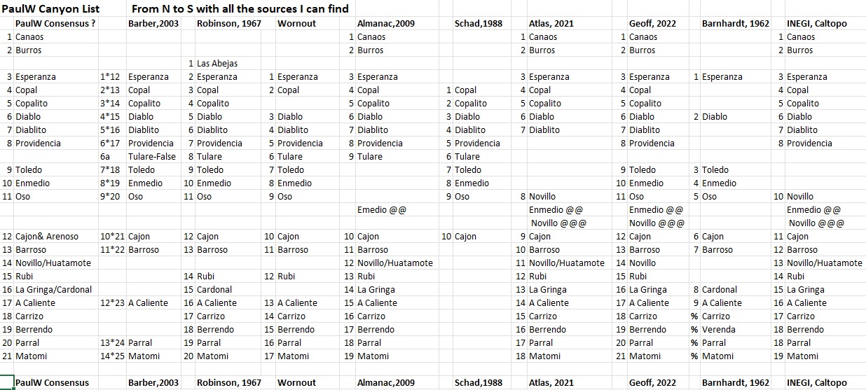
I spent some time documenting the canyon locations. The coords I believe are very accurate.
I made note of the size of the canyons.
I also made note of the blue lines on the INEGI topos which I call "Grid". Make it easier when studying the hard copy of the maps. - especially when my old fashioned method involves taping the screen shots together.
Anyway, here is my list of rank with regard to size of canyons. From the south
Comparing with Diablo a 10
Copal/Copalito a 5
Espiranza a 3
Burros a 4
Grid 53/54 a 7
Grid 57/58 a 5

My canyon traces are on page 5 of this thread
Here are the coordinates for the canyons


Attachment: Canyon LocationCOPY.xlsx (11kB)
This file has been downloaded 121 times

PaulW - 12-13-2021 at 06:12 PM

The trail from Santa Rosa Meadow goes over the ridge to the east to one of the tributaries of El Cajon. If you have the topo the trail exists on the Label "Canyon El Cajon" (No labels on Cal topo)
Good find Goat
=== ===
Quote: Originally posted by mtgoat666  
Quote: Originally posted by 4x4abc  
According to the text Canyon Santa Rosa is a contributory to Cañada El Cajon
30°49'43.78"N, 115°18'51.41"W
Rancho Santa Rosa close by in the little valley described in the text above.


Part of santa Rosa meadow drains eastward into a canyon that is tributary to El Cajon Canyon. There is an old indian/rancher trail that descends this canyon, one of the few canyon trails you can see on google earth. Trail is not open any longer, is all grown over (well, 5 years ago it was grown over the only time i hiked to santa rosa).

here is the trail 30°47'39.72"N, 115°18'43.08"W

here is santa rosa meadow 30°48'0.85"N, 115°20'43.51"W


4x4abc - 12-14-2021 at 01:01 AM

Quote: Originally posted by PaulW  
I spent some time documenting the canyon locations. The coords I believe are very accurate.
I made note of the size of the canyons.
I also made note of the blue lines on the INEGI topos which I call "Grid". Make it easier when studying the hard copy of the maps. - especially when my old fashioned method involves taping the screen shots together.
Anyway, here is my list of rank with regard to size of canyons. From the south
Comparing with Diablo a 10
Copal/Copalito a 5
Espiranza a 3
Burros a 4
Grid 53/54 a 7
Grid 57/58 a 5

My canyon traces are on page 5 of this thread
Here are the coordinates for the canyons


Google Earth does not read that format

4x4abc - 12-14-2021 at 01:04 AM

well, geoffff posted the answer little ways up
you just need to read what our members are posting

1921--Lower-California--Natural-Resources--Nelson.jpeg - 284kB

PaulW - 12-14-2021 at 06:26 AM

I mentioned my Grid locations only applied to paper Topos or downloaded topos from INEGI
Anyway, here is the JPG for the accurate locations of various canyon mouths. This will allow use of Google earth to see the canyons.

Canyon LocationCOPY.jpg - 330kB


Quote: Originally posted by PaulW  
I spent some time documenting the canyon locations. The coords I believe are very accurate.
I made note of the size of the canyons.
I also made note of the blue lines on the INEGI topos which I call "Grid". Make it easier when studying the hard copy of the maps. - especially when my old fashioned method involves taping the screen shots together.
Anyway, here is my list of rank with regard to size of canyons. From the south
Comparing with Diablo a 10
Copal/Copalito a 5
Espiranza a 3
Burros a 4
Grid 53/54 a 7
Grid 57/58 a 5

My canyon traces are on page 5 of this thread
Here are the coordinates for the canyons


PaulW - 12-14-2021 at 07:17 AM

Harald,
I agree a very large canyon, and is several times bigger than the INEGI
version of Esperanza. Also it meets the criteria of a fork leading NW like the old maps show for Esperanza. That fork may be Abejas?
The mouth of that canyon is 3311 12.215, -115 26.987

Screen Shot 2021-11-20 at 12.38.19 AM copy.jpg-thumb.jpg - 187kB


Quote: Originally posted by 4x4abc  
Cañon Esperanza in this last map image is a major canyon
It has no name on INEGI it has no name on our last name lists

I am surprised that an expansive canyon like that should have no name


Bud in a 1960 photo

David K - 1-17-2022 at 01:16 PM

With thanks to Vince...


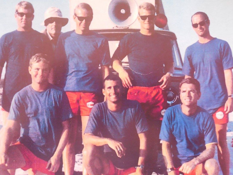
Photo from 1960. Bud Bernhard with hat in back, front row: Alan Hansen, Mike Neil, Mike Flynn. Back Row: Ed Paterson on right, not sure of the others except for Bud.

Bud's maps:
https://octopup.org/img/media/maps/baja/valle-chico/1962--Bu...

https://octopup.org/img/media/maps/baja/valle-chico/19631212...

[Edited on 1-17-2022 by David K]

geoffff - 3-21-2022 at 07:05 PM

Here is a circa 1935 photo from Margaret Wood Bancroft's trip, showing the Sierra San Pedro Martir canyons in order:
Matomi, Parral, Berendo, Carriso, Agua Caliente, El Cajon, Providencia


(click to enlarge)

David K - 3-22-2022 at 06:36 AM

Very cool, geoffff!
Can one figure out where the photo was taken from, using Google Earth or ??

geoffff - 3-23-2022 at 10:25 PM

Tricky to pin down for sure. With the small foreground hill in the center, and the slope on the left, maybe here? 30.7658, -115.0451

4x4abc - 11-3-2022 at 12:32 PM

Providencia!

4x4abc - 11-3-2022 at 12:38 PM

Cañada de Enmedio!

4x4abc - 11-3-2022 at 12:40 PM

Cañada El Novillo

PaulW - 11-4-2022 at 05:43 AM

One more correction


Notes.jpg - 126kB

[Edited on 12-4-2022 by BajaNomad]

The Trail La Grulla

bajatrailrider - 11-4-2022 at 11:34 AM

From El Coyote was done first time ever on Motos by El Coyote brothers . Total of 5 guys last year they had other Cowboys. Bring tents and food by horse back to La Grulla. They made it out to A gal I know rancho just east north of San Quintin. We have rode up there rancho road from bottom of rancho. Its a great 4X4 road but real bad at the time another abandon rancho at top. We hope to return there again soon.

David K - 11-4-2022 at 12:05 PM

La Grulla Meadow was discovered to be Casilepe of mission times, where Mission San Pedro Mártir was first established. Within about three months, the Dominicans had enough of the freezing cold (it was founded on April 27, 1794) and moved the mission about 2,000 feet lower in elevation where it remained until a particulary cold winter in 1811!

David K - 11-9-2022 at 05:40 PM

Big thanks to PaulW for working on the canyon list!
There was a nice photo post on Providencia Canyon, on Facebook today.

Lou Wells archive - Canyons

PaulW - 12-3-2022 at 10:37 AM


Canyons from archives from Lou Well. Coordinates from Google Earth
Lou’s written reports have been lost due to the web site being abandoned.
Esperanza 31° 8.437'N, -115 25.223
water almost always within a few hundred yards up the canyon

Picture2.jpg - 17kB pic 2

Picture3.jpg - 11kBPic 3

Diablo 312 4.491, -115 22.391
Entry into Diablo Canyon, which has waterfalls, and is access to climbing the mountain.
Parking 31 4.451, -115 21.925
Parking for the entry to Diablo Canyon, Cross a rock hill to the northwest and drop into the riverbed for your trip to the water and waterfall. 31 8.437, -115 25.223

Picture4.jpg - 22kB Pic 4

Picture5.jpg - 18kBPic 5

Provindincia 31 1.998, -1156 17.766
The entry to Providintia canyon, also a route for climbing Picacho del Diablo. It is said to have 7 waterfalls falling into 7 separate pools. Water is piped out to rancho's in the valley.

Picture6.jpg - 21kB Pic 6

Picture7.jpg - 20kB Pic 7

Picture8.jpg - 17kB Pic 8

En Medio 30 55.16, -115 15.073
No Pictures
== == =


Lou Well Archive cont.

PaulW - 12-3-2022 at 11:00 AM

Cajon 30 51.274, -115 14.110
Canyon Cajon - small waterfalls a short distance up the canyon. Large water tank near entry for storing water for cattle. Small private rancho at mouth. At one time in the past, a trail led up over the Sierra San Pedro Matir to Santa Rosa Meadow on the west side of the summit. Trail was washed away by storms several years ago.
Canyon Cajon - small waterfalls a short distance up the canyon. Large water tank near entry for storing water for cattle. Small private rancho at mouth.

At one time in the past, a trail led up over the Sierra San Pedro Matir to Santa Rosa Meadow on the west side of the summit. Trail was washed away by storms several years ago

Barrasa 30 49.744, -115 13.237
No pictures

Agua Caliente Canon 30° 39.427'N, -115° 9.820'W
Entry point for Agua Caliente Canon. Hot springs being developed several miles into canyon. Picture is water tank in mouth of the canyon.

Picture9.jpg - 23kB Pic 9

Picture10.jpg - 10kB Pic 10

Picture11.jpg - 19kB Pic 11

Picture12.jpg - 18kB Pic 12

Parking area for visiting the hot springs. 30° 38.929'N, -115° 12.166'W
Agua Caliente hot springs 30° 38.841'N, -115° 12.457'W
Several hot pools bubbling from the ground in this area - Temperature is about 142 deg. so be careful

Picture13.jpg - 23kB Pic 13

Picture14.jpg - 88kBPic 14

As of spring of 2022 to get to the spring required 4x4 with winch and the spring was not noticeable.
As of fall 2022 after the hurricane a report that the road in now impassable passed the gate.

Berendo Canyon 30° 33.753'N, -115° 7.853'W
Berendo canyon with it's hillsides covered with Blue Palms is a jewel. A short walk up the canyon thru the palms brings you to wonderful views of pools and the flowing water.
30° 32.467'N, -115° 7.956'W

Picture15.jpg - 19kB Pic 15

Picture16.jpg - 19kBPic 16
Continued next
=== ===

Lou Well Archive Cont.

PaulW - 12-3-2022 at 11:24 AM

Berrendo Cont.

Picture17.jpg - 17kBPic 17

Parral Canyon wash 30° 33.159'N, -115° 5.278'W
Locked Gate? 30° 32.831'N, -115° 5.509'W
Rancho Parral 30° 29.399'N, -115° 6.991'W
Great oasis in a wonderful canyon. A locked gate now keeps visitors from the ranch area of the canyon.

Picture18.jpg - 20kBPic 18

Picture19.jpg - 18kB Pic 19

Picture20.jpg - 23kB Pic 20

Picture21.jpg - 21kB Pic 21

Matomi entry from Valle Chico 30° 29.655'N, - 115° 1.542'W
Rancho Matomi 30° 27.412'N, - 115° 4.872'W
Rancho Matome - with the Blue Palms along the waterway below - a beautiful spot.

Picture22.jpg - 11kB Pic 22

Picture23.jpg - 17kB Pic 23

David K - 12-3-2022 at 12:01 PM

Bravo!
Sure miss Lou...
Thanks for posting these.

4x4abc - 12-3-2022 at 12:01 PM

good stuff!

PaulW - 12-3-2022 at 01:49 PM

An ongoing project for all the canyons.
Drove to the mouths of Provedencia, Tulare, Toledo, EnMedio, and near Oso on 12/2/22
All canyon entrances located using my waypoints from Lou's above, and Caltopo/Avenza.
Pics and tracks later.

4x4abc - 12-3-2022 at 11:12 PM

I checked all your waypoints
spot on!
then I got sidetracked with Cañada Taraiso
found 5 new airstrips in the process
and a major cemetery in a nice desert setting
Panteon El Medanito


Panteon El Medanito Mexicali copy.jpg - 268kB

Field checking canyons

PaulW - 12-11-2022 at 10:56 AM

Canyon field effort
On 12-2-22- 4 of us traveled to the west canyons
Providencia, Tulare, Toledo, EnMedio, and OSO
No success for Providencia. Could not get close at all. We found rough, overgrown roads and had to cross fences.
We had a great approach to Tulare, EnMedio and Toledo. By driving up the newfound washes left over by hurricane Kay.
Had lunch at Tulare and spent some time in EnMedio
Forgot to take a picture of Toledo. It looked very similar to Tulare. Both are large canyons.
No luck for OSO. My guess is we missed the correct wash.
To be continued in 2023
Note Images 5, 6, 7 have incorrect coordinates.


12-2-22 canyon travel.jpg - 70kB Providencia Search.jpg - 82kB 1-2132-.jpg - 135kB 2-2136.jpg - 168kB 3-2138.jpg - 125kB 4-2139.jpg - 147kB 5-2140.jpg - 156kB 6-2141.jpg - 149kB

PaulW - 12-11-2022 at 11:04 AM


8-2144.JPG - 164kB 10-2146.JPG - 114kB 11-2148.jpg - 128kB 12-2149.JPG - 123kB 14-2153.JPG - 198kB 15-2155.jpg - 165kB

David K - 12-11-2022 at 11:08 AM

Wonderful!
Keep the good field work up, Paul.

 Pages:  1  2