BajaNomad

100 Day Walk Around the Baja coastline: San Felipe to Rosarito

 Pages:  1    3    5  ..  7

David K - 5-20-2012 at 08:34 AM

Quote:
Originally posted by tripledigitken
Quote:
Originally posted by Skipjack Joe
They should be reaching Coco's oday in about 2 hours if they keep walking at current rate.

They started at 4:30 this morning.


will they turn left (as it appears on their route map) or head straight to Chapala?????


They are about 2-3 miles north of Coco's Corner, so we shall see soon!

LIVE SPOT TRACKING

Skipjack Joe - 5-20-2012 at 08:40 AM

I think they'll turn left, Ken. Left is usually better than right. :lol:

A couple of theories on why they "cheated" back there:

a) They reached the end of the paved road at Okie's Landing and were now stuck with the stroller.

b) Unless they catch up to their schedule their plans are doomed due to the coming wet air on the Cortez. They have to be out of the Cortez by July and that's what the schedule calls for.

Walk Dates:
•San Felipe – Sat, May 12
•Puertecitos – Mon, May 14
•Gonzaga Bay – Wed, May 16
•Mision de Calamajue – Fri, May 18
•Bahia de los Angeles – Mon, May 21
•San Ignacio – Tues, May 29
•Santa Rosalia- Thurs, June 1
•Mulege – Sun, June 3
•Loreto – Thurs/Fri, June 7/8
•La Paz – Thurs/Fri, June 21/22
•Los Barriles – Mon, June 25
•San Jose del Cabo – Fri, June 29
Cabo San Lucas – Sat, June 30
•Todos Santos – Mon, July 2
•Bahia de Magdalena – Mon/Tues, July 9/10
•Laguna San Ignacio – Fri/Sat/Sun July 20/21/22
•Guerrero Negro – Fri, July 27
•Santa Rosalillita – Tues, July 31
•(El Rosario) – Thurs, Aug 9
•San Quintin – Sat, Aug 11
•Ensenada – Thurs/Fri, Aug 16/17
•Puerto Nuevo - Click-On, Sun, Aug 19

Skipjack Joe - 5-20-2012 at 08:47 AM

The white spot on road in bottom right is Coco's place.

bajawalk7.jpg - 50kB

tripledigitken - 5-20-2012 at 08:48 AM

Quote:
Originally posted by Skipjack Joe
I think they'll turn left, Ken. Left is usually better than right. :lol:

A couple of theories on why they "cheated" back there:

a) They reached the end of the paved road at Okie's Landing and were now stuck with the stroller.

b) Unless they catch up to their schedule their plans are doomed due to the coming wet air on the Cortez. They have to be out of the Cortez by July and that's what the schedule calls for....


I'm hoping we get an update from them when they get to BOLA. The stroller may have been replaced by a new and improved off road model.

Ken

Taco de Baja - 5-20-2012 at 08:49 AM

I'm betting they will camp at the intersection as they will be arriving around their usual break time. We won't know if they go left or right 'till later. Plus, keeps the suspense up :yes:

Skipjack Joe - 5-20-2012 at 09:17 AM

Quote:
Originally posted by tripledigitken
Quote:
Originally posted by Skipjack Joe
I think they'll turn left, Ken. Left is usually better than right. :lol:

A couple of theories on why they "cheated" back there:

a) They reached the end of the paved road at Okie's Landing and were now stuck with the stroller.

b) Unless they catch up to their schedule their plans are doomed due to the coming wet air on the Cortez. They have to be out of the Cortez by July and that's what the schedule calls for....


I'm hoping we get an update from them when they get to BOLA. The stroller may have been replaced by a new and improved off road model.

Ken


Or their faster pace since alphonsinas could be due to carrying less weight. Perhaps the supply car is now transporting everyhing other than water and the day's food snacks (about <20lbs). I'm assuming that 2 gals of water per person is enough.

AT COCO'S CORNER

David K - 5-20-2012 at 09:49 AM


lizard lips - 5-20-2012 at 01:53 PM

What an adventure..! I hope they make it and have plenty of stories to tell. If you have the desire you can finish. I'm impressed. The most walking I do is at 2 am and 6 am from the bed to the bathroom and back. :light:

tripledigitken - 5-20-2012 at 08:05 PM

still at Coco's.........

Skipjack Joe - 5-21-2012 at 07:51 AM

8AM and no sign of movement.

Is it time to play the taps?

goldhuntress - 5-21-2012 at 08:38 AM

I looked at the weather for BOLA and it's hot the next couple days then a cooling for a few days then it gets REALLY HOT, like 100 to 108 for a few weeks! I don't see how they can do it unless they only walk at night.
http://www.accuweather.com/en/mx/bahia-de-los-angeles/231766...

David K - 5-21-2012 at 01:35 PM

Just looked at 1:34pm, their last signal was ~4 hours ago (9:18am) and still at Coco's Corner.

mtgoat666 - 5-21-2012 at 01:52 PM

Quote:
Originally posted by David K
Just looked at 1:34pm, their last signal was ~4 hours ago (9:18am) and still at Coco's Corner.


perhaps they are doing like bicycle stage racing, mondays are rest days... or perhaps their batteries are dead, figuratively or literally...

David K - 5-21-2012 at 05:58 PM

Almost 6 pm and the 'live' tracking only shows 9:18 am at Coco's Corner as their position.

LIVE SPOT TRACK

TMW - 5-22-2012 at 06:23 AM

Why does the latest spot tracker show 44 to 50 on the road to hwy 1 and 43 at Cocos when yesterday 50 was at Cocos?

Taco de Baja - 5-22-2012 at 07:05 AM

Looks like they did another 8-9 mile car ride to get to today's starting point heading to Hwy-1....Or, forgot to turn the Spot on again. :?: :rolleyes: :light:

TW, 50 is always the latest, most up to date track point as only 50 points load per viewable page.

Taco de Baja - 5-22-2012 at 07:45 AM

If they drove, it's sure the easy way over the 250m (820 ft) grade out of Coco's.

But, they have reached Hwy 1 as of 7:11 this morning.....

2012-05-22_Baja-walk-sm.jpg - 39kB

David K - 5-22-2012 at 08:28 AM

Wow, not only are they not walking all of the route, but they aren't keeping to their planned route. Mision de Calamajue is on the OTHER road out of Coco's Corner.

David K - 5-22-2012 at 08:43 AM

Well, anyway... they are walking sections, anyway... If they were to do it again, I am sure the time of year would be changed since summer is an oven in that desert. I wish them well, and look forward to hearing from them... maybe from Bahia de los Angeles? Walking sections of the route and riding to the next section is the only way they could keep to that schedule of 20 miles a day average.


Just a few minutes ago they were on Hwy. 1 southbound from Rancho Laguna Chapala.

Skipjack Joe - 5-22-2012 at 08:46 AM

It's possible that they walked that section yesterday because the spot check was dormant for a full day.

They're on the hwy now. I wonder what's next because they're no longer following their planned route.

David K - 5-22-2012 at 08:58 AM

Sure, I guess they can turn it off... then on... then off with these multi mile gaps.

What about the reason why they didn't stick to the plan of going via Mision de Calamajue.... a 4WD road, but not an issue if walking? They are going the longer higher elevation route that just happens to be a 2WD friendly road.

Having a chase vehicle is smart, and not killing yourself for a cause is also smart. It is just that they never mentioned any of that support when they said they were walking for 100 days and nearly 2000 miles.

tripledigitken - 5-22-2012 at 09:14 AM

They have a very polished website with supporters and contacts, which was designed to post updates. They posted from "the road" early on, perhaps their support staff will relay some info soon.

goldhuntress - 5-22-2012 at 09:22 AM

It would be nice if they would do a custom check in once in awhile to let people know whats going on. For example"Left coco 2am forgot checkin" or "had to take ride". You can only use 41 characters for the custom message so it has to be short or sometimes when we use ours we do 2 or 3 at a time to share more of what we are up to. Also the Spot allows 14 predefined messages so they could make a few more of those to describe more common scenarios.

tripledigitken - 5-22-2012 at 09:29 AM

Now that they are on/adjacent to Mex 1, maybe a passing Nomad will stop, take some photos, and get us all caught up on their plans?

(they are at the intersection of Mex 5/turnoff to Gonzaga and Mex 1/ at Laguna Chapala.)

N 29.37543 W 114.37439

[Edited on 5-22-2012 by tripledigitken]

norte - 5-22-2012 at 09:35 AM

I wonder if there would be so much negativity if this person were a Nomad.

Until you walk in someone else's shoes........... I sure will be interested in reading about there journey once they are done.

goldhuntress - 5-22-2012 at 09:44 AM

They're on the road again!!!

Skipjack Joe - 5-22-2012 at 09:46 AM

Quote:
Originally posted by David K
Sure, I guess they can turn it off... then on... then off with these multi mile gaps.

What about the reason why they didn't stick to the plan of going via Mision de Calamajue.... a 4WD road, but not an issue if walking? They are going the longer higher elevation route that just happens to be a 2WD friendly road.

Having a chase vehicle is smart, and not killing yourself for a cause is also smart. It is just that they never mentioned any of that support when they said they were walking for 100 days and nearly 2000 miles.


As I recall there is some mention about some support being provided. I remember reading that they were looking for additional people to volunteer.

David K - 5-22-2012 at 10:05 AM

Quote:
Originally posted by norte
I wonder if there would be so much negativity if this person were a Nomad.

Until you walk in someone else's shoes........... I sure will be interested in reading about there journey once they are done.


No negativity seen, what we appeciate are facts. If not walking the entire trip was planned, then be up front. If riding sections was a change, then fine... let us know when they can. Beats quitting. The heat alone is punishment.

As I said earlier, any adventure in Baja is a great one! Walking is only one kind of adventure.

[Edited on 5-22-2012 by David K]

Cypress - 5-22-2012 at 10:50 AM

I thought they were gonna walk the Baja coastline? Packing their own gear etc. Now they're hitching rides? It's still gonna be an adventure! Just a whole lot less so.:D Takes a lot of the physical aspect out of it.

norte - 5-22-2012 at 11:11 AM

Other travelers , who did not get this criticism, Got unplanned help, rides etc. When tired in need of the coast, when lost, including the Mexican Army, Come on. Why the "facts" issue here. Guess the should have asked Nomads for help. Like I said. lets see you walk a mile

Quote:
Originally posted by David K
Quote:
Originally posted by norte
I wonder if there would be so much negativity if this person were a Nomad.

Until you walk in someone else's shoes........... I sure will be interested in reading about there journey once they are done.


No negativity seen, what we appeciate are facts. If not walking the entire trip was planned, then be up front. If riding sections was a change, then fine... let us know when they can. Beats quitting. The heat alone is punishment.

As I said earlier, any adventure in Baja is a great one! Walking is only one kind of adventure.

[Edited on 5-22-2012 by David K]
:lol::lol::lol::lol::lol::lol:

Cypress - 5-22-2012 at 11:29 AM

norte, You tell someone you're gonna walk along the coastline of Baja carrying a heavy load, then hitch a ride miles from the coast? Only pointing out a little, small, tiny change in their game plan. If that, in your opinion is being negative, so be it.:biggrin: Count me as being mucho negative. :D
Skipjack Joe - 5-22-2012 at 11:33 AM

Quote:
Originally posted by Cypress
I thought they were gonna walk the Baja coastline? Packing their own gear etc. Now they're hitching rides? It's still gonna be an adventure! Just a whole lot less so.:D Takes a lot of the physical aspect out of it.


They never intended to fully follow the coast. This link is from David's page 3 link. It shows what the original intention had been.

http://maps.google.com/maps/ms?msid=200055380007908955283.00...

As to why they haven't followed the original calamajue road. Probably the support vehicles didn't want to go there. Hard to say. Perhaps Coco talked them out of it. Yes, it would be nice if a msg was included in the Spot checkin.

goldhuntress - 5-22-2012 at 11:55 AM

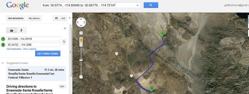
It's 17.3 miles from Coco's to where they checked in at 11:05, about 3.5 south of Chapala.

Cypress - 5-22-2012 at 12:05 PM

Did they walk or ride?:D

Next Challenge

Skipjack Joe - 5-22-2012 at 12:16 PM

Will they follow the paved hwy all they way to BOLA or follow the original planned route?

As you can see support vehicles can't get through that route.

If the support vehicles are carrying all their belongings except water then they're pretty much married to them and will only walk the good roads.

bajawalk8.jpg - 38kB

goldhuntress - 5-22-2012 at 12:34 PM

Quote:
Originally posted by David K
17.3 miles by straight line, not road miles.

No, not a straight line.


Cypress - 5-22-2012 at 12:39 PM

At this point, who knows whether they walked, rode, or sprouted wings. I for one, will keep watching.:yes:

It's my way or the highway

Skipjack Joe - 5-22-2012 at 12:44 PM

There's no way they're going to follow the planned route. This is an enlarged view of a section of it. The string that starts at the SPOT logo on the left and crosses the image is the planned route. It would take a Ken Cooke to drive through there. This is tougher than the calamajue section then skipped. They must have thought of doing the cutoff with no support when plans were drawn up.

It's the paved road to BOLA. Me Thinks.

bajawalk9.jpg - 43kB

David K - 5-22-2012 at 02:05 PM

Quote:
Originally posted by goldhuntress
Quote:
Originally posted by David K
17.3 miles by straight line, not road miles.

No, not a straight line.


I apologize, I presumed you were watching their progress on the Spot maps... which only can record a point to point straight lines. Since they turned off the Spot when they left Coco's and turned it on again half way to Chapala you get a straight line instead of their true route... Again, I am sorry for presuming!

mscowpatty - 5-22-2012 at 02:16 PM

Buen Viaje! The Cowpatty group enjoyed visiting with you on your way south. A very ambitious undertaking and a great way to get people involved in some very worthwhile causes. Safe travels.

Stick a fork in it- this topic is dead

thebajarunner - 5-22-2012 at 02:32 PM

dead and deader
give it a rest

[Edited on 5-23-2012 by thebajarunner]

David K - 5-22-2012 at 05:19 PM

At 11:05 am today they stopped, or turned off their Spot... In the Laguna Chapala valley. As of 5:15 pm, there has been nothing new.

LIVE SPOT TRACKER

shari - 5-22-2012 at 05:28 PM

just to clarify about Mike Younghusband's taking a ride...he had decided to skip Asuncion because it was just too far off his trail to get in and out and still reach the tip in time....so we kidnapped him so he could spend Christmas among friends and Don Kay could rest up a bit...he walked out of here though! So he didnt want a ride but we MADE him come!!!:biggrin:

David K - 5-22-2012 at 05:41 PM

Gotta love Baja's and Bahia Asuncion's hospitality!

Same happened to him at Lopez Mateos!

goldhuntress - 5-22-2012 at 07:54 PM

They started up again at 5:28pm and stopped with a check in at 6:42pm. They added 2.8 more miles. Good for them!

[Edited on 5-23-2012 by goldhuntress]

goldhuntress - 5-23-2012 at 07:37 AM

They got started at 5:55am today. From their track at 7:24am they have 20.2 miles to the LA Bay turn off. If they push hard they could make it there today!

Skipjack Joe - 5-23-2012 at 08:05 AM

That would be difficult. It's 8AM and they've done 5 miles. By quitting time, 11AM, they'll have done 12 miles, perhaps. That's half way.

They gotta get up earlier.

David K - 5-23-2012 at 08:22 AM

Well, they have a solid track from when they turned the Spot back on between Coco's and Chapala. At 8 am, they were between the road east to Calamajue Canyon and the road west to San Antonio and the Pacific.


Skipjack Joe - 5-23-2012 at 08:43 AM

If you look at the planned route you will see that they were never touch hwy1 on the way to BOLA. The calamajue road was going to lead to another dirt road that eventually came out on the paved hwy just before Agua Amarca going to BOLA.

David K - 5-23-2012 at 08:46 AM

Quote:
Originally posted by Skipjack Joe
If you look at the planned route you will see that they were never touch hwy1 on the way to BOLA. The calamajue road was going to lead to another dirt road that eventually came out on the paved hwy just before Agua Amarca going to BOLA.


Yes, that is the Baja 1000 course.

goldhuntress - 5-23-2012 at 10:16 AM

Well, they just checked in so if they stick with their routine they will stay put and maybe head out again later. They walk 4 hours and went 9.2 miles. It's 14.5 to the BOLA turn off. I wonder how hot it is and what they are pushing. It is so much harder on the feet to walk on pavement rather than dirt, in my experience, and it's probable even worse with the really hot pavement there.

coconaco - 5-23-2012 at 12:10 PM

I would lay over in Catavina - pool and bar,
and blow off Bola to get back on schedule

Curt63 - 5-23-2012 at 12:43 PM

They are already south of catavina, but skipping BOLA would be brilliant.

Sprocket - 5-23-2012 at 04:24 PM

This area around El Crucero is NASTY! Pea gravel, sandy, whooped out bumps. These people are crazy, I wouldn't plan a dirt bike trip this time of year let alone be caught dead walking out there..
Our race team uses several Spot trackers. Chase trucks, prerunners and even the race car, that said they are only as good as the person who is using or forgetting to use them. Every race, out of the 10 Spots we may have 6 or 7 tracking and thats after $200.00 in sat phone calls to remind every one to check them and turn them on! I have seen it all from these units, we even had one tracking in Utah when we were in San Felipe.

I would like to see some updates from these folks, Iam sure that they have gotten the word about there tracking issues by now. Maybe they can fill us in.

Again best of luck to them.

David K - 5-23-2012 at 05:03 PM

At 4:55pm they have passed just south of El Crucero and staying on Hwy. 1, not the Baja 1000 parallel road they had proposed using.

David K - 5-23-2012 at 06:44 PM

OK, at 6:35 pm, they are just north of the original road to Bahia de los Angeles (via Desengaño), and have left Hwy. 1 onto the old main Baja road (pre-1973), just to the west of Mex. 1.


[Edited on 5-24-2012 by David K]

goldhuntress - 5-23-2012 at 06:57 PM

Looks like they've checked in for the night. They are 8.6 from the turn off. My BF is at Jardines tonight and heading to GN tomorrow. He's going to look for them and say hello. Anybody have any questions they want asked? Can you think of anything they might want? He'll bring them some cold drinks for sure.

David K - 5-23-2012 at 07:49 PM

They still could use the original L.A. Bay dirt road, as they are just north of it. Chances are your BF will not see them if he is bound for Guerrero Negro... Unless they totally pass on following the coastline!

David K - 5-23-2012 at 07:53 PM

Quote:
Originally posted by goldhuntress
Looks like they've checked in for the night. They are 8.6 from the turn off. My BF is at Jardines tonight and heading to GN tomorrow. He's going to look for them and say hello. Anybody have any questions they want asked? Can you think of anything they might want? He'll bring them some cold drinks for sure.


Sure, ask them why there are big gaps in the tracking, specially past Coco's... and why they didn't take the planned route past Calamajue Mission? Do tell them there are thousands following them on Spot and we wish them well and do not blame them at all for taking rides or rests in the intense heat!

Curt63 - 5-23-2012 at 08:01 PM

Tell them the humidity will rise on the SOC and their San Felipe to Gonzaga hike will feel cool compared to whats coming.....take the Pacific side down!

Skipjack Joe - 5-23-2012 at 08:11 PM

Mostly tell them how much we support them and how much we admire what they're doing.

It's hard to pick out one single suggestion from all we've posted. If there is one that is most important it would be to show them the hourly temps for an entire 24 hr day and encourage them to get an earlier start each day. They can make it easier on themselves.

Tell them to check the internet at BOLA and read the entire thread.

You obviously have never logged on in LABay

thebajarunner - 5-23-2012 at 10:09 PM

Quote:
Originally posted by Skipjack Joe
Mostly tell them how much we support them and how much we admire what they're doing.

It's hard to pick out one single suggestion from all we've posted. If there is one that is most important it would be to show them the hourly temps for an entire 24 hr day and encourage them to get an earlier start each day. They can make it easier on themselves.

Tell them to check the internet at BOLA and read the entire thread.


Reading the entire thread at Bahia de LA net speed would consume the better part of a week.
Trying to just handle 3 or 4 key issues on line there is a painful experience.

Skipjack Joe - 5-24-2012 at 11:43 AM

At the BOLA turnoff now. Probably guzzling cokes.

bajawalk10.jpg - 41kB

Curt63 - 5-24-2012 at 12:39 PM

Good decision to bypass BOLA!

[Edited on 5-24-2012 by Curt63]

Skipjack Joe - 5-24-2012 at 12:46 PM

So what's going to consitute the circumnavigation of the peninsula? Down hwy1 and back up hwy1?

MikeYounghusband - 5-24-2012 at 12:53 PM

Just found this thread. WOW, this is incredible. The heat on the hwy has to be unbearable. I just got back from 5 days exploring the Conception Pennisula and we had to hunker down in the shade from early afternoon on. Best of luck and God Speed.

Curt63 - 5-24-2012 at 12:58 PM

I say walk to CSL. 1000 miles in 100 days. Achievable, challenging and honorable.

Cypress - 5-24-2012 at 02:02 PM

Quote:
Originally posted by Curt63
I say walk to CSL. 1000 miles in 100 days. Achievable, challenging and honorable.

:biggrin:

Totally Changed Route

David K - 5-24-2012 at 09:11 PM

Somehow, waklking down a paved highway in the central desert doesn't seem as appealing as following the coast, with slightly cooler temps... Perhaps their support car is not up for any dirt roads?

Anyway, they shot on past the L.A. Bay highway jcn. and the last Spot was about 4 pm at the village of Punta Prieta (close to the paved runway of Punta Prieta, next to Hwy. 1)


Looking forward to hearing if Gold's boyfriend found them today... Best Wishes!!

woody with a view - 5-24-2012 at 09:16 PM

if it was me i'd follow the path of least resistance=highway. why would they want to cross over every hill and dale while kicking rocks and spooking rattlers?

they said they were going to cabo, right? that's the way i'd go. the crows fly straight for a reason.....

David K - 5-24-2012 at 09:22 PM

No, they were going to stay on roads, paralleling the coast as much as possible... and Cabo is not the goal... just the HALFWAY POINT. 1,800 miles in 100 days was the proposal... San Felipe to Rosarito Beach (via Cabo San Lucas).

woody with a view - 5-24-2012 at 09:26 PM

well, H1 parallels the coast for the majority of its length!?!?!?

if they make cabo then the rest is $ for charity.....:light:

David K - 5-24-2012 at 09:30 PM

Yes, it sure does... and it is 30-40 miles from either coast right where they are now... in the dead center!

Just think how much nicer it would have been to walk along the Seven Sisters in the gloomy, cold fog that hugs the Pacific Coast in the hot months!

Skipjack Joe - 5-24-2012 at 09:53 PM

I agree with David here. The hike has completely lost it's identity.

It's baffling. Today they started at 7AM and hiked through the hottest part of the past 24 hours.

In fact why was this hike scheduled to start in May going south. You would have thought November would have been the right choice. With lower temps they probably could have performed a circumnavigation.

Well, this has been an important lesson for them. I'm sure they're not thrilled about the compromises made. Every challenging leg of the journey has been skipped.

Perhaps they should quit, reschedule a more realistic trip, and try again at a later date.

Still I respect the spirit of not giving up. They must know by now how much they miscalculated. And yet they continue as best as they can.

David K - 5-24-2012 at 10:04 PM

Quote:
Originally posted by Skipjack Joe
I agree with David here. The hike has completely lost it's identity.

It's baffling. Today they started at 7AM and hiked through the hottest part of the past 24 hours.

In fact why was this hike scheduled to start in May going south. You would have thought November would have been the right choice. With lower temps they probably could have performed a circumnavigation.

Well, this has been an important lesson for them. I'm sure they're not thrilled about the compromises made. Every challenging leg of the journey has been skipped.

Perhaps they should quit, reschedule a more realistic trip, and try again at a later date.

Still I respect the spirit of not giving up. They must know by now how much they miscalculated. And yet they continue as best as they can.


Ditto what Igor said...
I do not want to sound like I am being negative! I said at the very beginning of the questionable skips in the track and altered from planned route, that any WALK in Baja IS an adventure and it is fun to follow their trip with Spot.

So, you guys do what you must and what ever you do, we will cheer you on... our commentary is just thinking out loud wondering why on some of these things.

Looking forward to hearing from you guys!

goldhuntress - 5-24-2012 at 10:46 PM

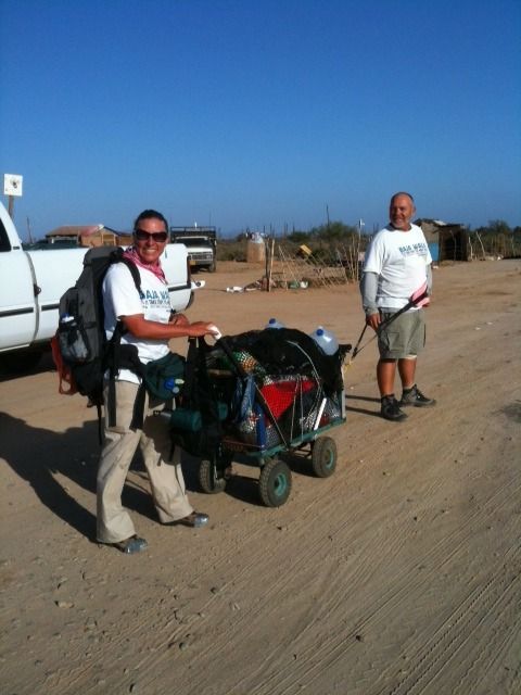
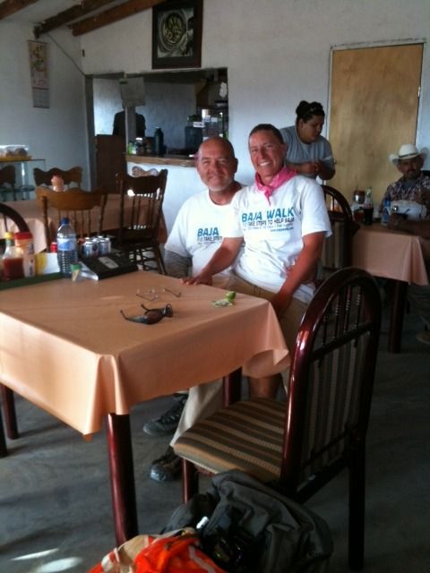
So, I just had a long chat with my BF who spent about 1 1/2 hours with John and Rachel in a little restaurant in Punta Prieta. They are in very good spirits and were really pleased to find out that the thread here is going on and that people were watching their progress on the Spot tracking. The course changed due to John's previously mentioned old injuries flaring up. Now he is unable to carry his pack. Some friends got together and built the cart shown in the photo and delivered it to them. He wears a harness and pulls it and it looks like she can push too. When he asked about getting rides they said they have walked the whole way, no rides. They have had to adjust the route because of the cart. He's got blisters on top of blisters, she's got sore calves today but other that that they are fine. They eat along the way when possible and also have dehydrated food packed. They should be in GN by Tuesday and will have internet and hopefully post here. My BF brought them a Styrofoam cooler filled with drinks, pedealyte, a couple tall Tecates, limes and fruit. They all had a good time chatting and are hooking up again in GN. By the way it was only 65-70 there today. That's why they slept in.


[Edited on 5-25-2012 by goldhuntress]

David K - 5-25-2012 at 08:09 AM

thank you!

DENNIS - 5-25-2012 at 08:21 AM

Quote:
Originally posted by goldhuntress
He's got blisters on top of blisters,


OUCH....That will be worse than the heat. Painful and easily infected.
I wish them well.

goldhuntress - 5-25-2012 at 08:42 AM

They are on the road again! Just wanted to add that the Spot they are using does not have the capability to send a message other than the pre written ones. They said it would be nice to be able to but you do need a smart phone to do that with the Spot Connect and I don't know how they would keep the phone charged while on the road. You use the phone for the keypad to type the message.

Skipjack Joe - 5-25-2012 at 08:51 AM

Quote:
Originally posted by goldhuntress


Thank you for filling us in on the information, goldhuntress.

I have a question about Rachel's shoes. It looks as though the front is ductaped. Any idea why?

And a comment about the harness. It doesn't look that comfortable (ask any Volga boatman). I'm wondering how much easier it is now. Of course there is a lot of weight in that carriage. She must be doing a lot of pushing on the uphills. Going downhill could be tricky as well.

Thank goodness for the cool weather, huh? By the time it warms up they'll be on the plain to Guerrero Negro with it's cool weather. So they're covered all the way to GN, maybe Vizcaino.

Bien viaje.

[Edited on 5-25-2012 by Skipjack Joe]

goldhuntress - 5-25-2012 at 08:56 AM

Yes, her shoes are duct taped. She said the pavement was hot and her soles were sticking to it and then the sole pulled away from the shoe so she taped it.

Volga boatmen

Skipjack Joe - 5-25-2012 at 09:06 AM

Poor John (Ivan, technically).

[Edited on 5-25-2012 by Skipjack Joe]

ILYA_REPIN-Volga_Boatmen-1873.jpg - 50kB

DENNIS - 5-25-2012 at 09:07 AM

It's a heavy mist here...[chippi chippi....as the locals call it] and moving soutward. Don't know if it will catch up to them, but they should be aware of it.

TMW - 5-25-2012 at 09:27 AM

Love the picture

DENNIS - 5-25-2012 at 09:46 AM

Quote:
Originally posted by TW
Love the picture


Yeah....the guy at the end of the line doesn't seem to be having near as much fun as the others. :lol:

goldhuntress - 5-25-2012 at 01:18 PM

They just entered a steep, gnarly part of the walk. I don't believe there's much of a shoulder there.

MikeYounghusband - 5-25-2012 at 06:14 PM

bump

coconaco - 5-26-2012 at 09:32 AM

Another big car ride?

memo:
do not leave the spot in the support vehicle.

woody with a view - 5-26-2012 at 09:50 AM

what's the spot link? the one on their site won't load past the spot header.

Skipjack Joe - 5-26-2012 at 09:53 AM

Page 3 of this thread. DavidK's post.

BajaNomad - 5-26-2012 at 09:54 AM

Quote:
Originally posted by woody with a view
what's the spot link? the one on their site won't load past the spot header.


http://share.findmespot.com/shared/faces/viewspots.jsp?glId=...

Skipjack Joe - 5-26-2012 at 10:01 AM

Quote:
Originally posted by coconaco
Another big car ride?

memo:
do not leave the spot in the support vehicle.


3.2 miles in 10 minutes. What is that? 20mph when they first started this morning.

David K - 5-26-2012 at 10:05 AM

They are in Nuevo Rosarito at 930. Between the Santa Rosalillita road and there they went into warp drive!

goldhuntress - 5-26-2012 at 10:05 AM

So them or the spot moved really quickly, about 3.2 miles for each of the last 2 tracks and now no more tracks so I think the spot is inside somewhere in the little burb on the map. So they sent the gear ahead or got a ride. Hope they are OK. BTW there is no support vehicle.

woody with a view - 5-26-2012 at 10:05 AM

still won't load!?!?!?!

Taco de Baja - 5-26-2012 at 10:10 AM

Quote:
Originally posted by woody with a view
still won't load!?!?!?!


Works fine on my computer.
Maybe some setting in your browser is blocking it?

goldhuntress - 5-26-2012 at 10:14 AM

My BF was planning on driving to see them tomorrow morning to give them more sunscreen which they were using sparingly and both had sunburn. I've had already sent an email suggesting he go today. Hopefully he can go and will find out how they are. He was VERY concerned for them on the stretch of road.
His email "I've been thinking I should deliver the sunscreen. Her arms were sunburned cause she (they) was wearing their Walk Baja short sleeved shirts and she was using what sunscreen she had left sparingly. Forgot to mention that Rachel said they spend quite a bit of time doctoring/taping Johns feet every day. And they said they were drinking about 1 1/2 gallons of water a day each, plus lots of hi-calorie food. After leaving them, I was driving up that really nasty grade with the guard rails on both sides, blind corners and no shoulder and felt very worried for them."

[Edited on 5-26-2012 by goldhuntress]

DENNIS - 5-26-2012 at 10:14 AM

Quote:
Originally posted by Taco de Baja
Quote:
Originally posted by woody with a view
still won't load!?!?!?!


Works fine on my computer.
Maybe some setting in your browser is blocking it?


No problem here either, Woody. Gotta be you. Maybe too much security?

woody with a view - 5-26-2012 at 10:19 AM

i dunno. it's the only site i have a problem.

David K - 5-26-2012 at 12:17 PM

Just looked and they are still in Rosarito, just north of the arroyo crossing, at 12:10 pm Sat.
 Pages:  1    3    5  ..  7