BajaNomad

What Is West Baja walk

 Pages:  1  ..  3    5    7  ..  9

mtgoat666 - 3-9-2013 at 03:21 PM

an adventure video for all you arm chair adventurers:

http://youtu.be/vC8gJ0_9o4M

:lol::lol::lol:

David K - 3-9-2013 at 04:18 PM

Quote:
Originally posted by TW
So where they at now?


Hi Tom... they are at (or where this morning) Bahía Blanco/ Punta Blanco...


The link for their Spot signal is: http://www.whatiswest.com/where-are-we/

micah202 - 3-10-2013 at 11:19 AM

Quote:
Originally posted by David K


Hi Tom... they are at (or where this morning) Bahía Blanco/ Punta Blanco...


........how far through this isolated stretch does that make them??

......such a contrast between the first section through the most populated section of baja,,,,to very-much the opposite.

......I can't imagine there's a fishcamp every 10 miles now,,,,so the lads are likely relying on their own de-salinator and cooking now(?),,,,,as well as no communications except for their location 'pings',,,so I guess our only sign that they're okay is to see that 'ping' continue to move down the coast,,,,and no distress calls

edit....found this on their facebook,,,guess there's communications afterall,,,since they're focused of the fauna,,I guess they're doing fine!(?)

....from facebook.... WHAT IS WEST ,,15 hours ago.

.........''It doesn't take much time away from the highway to see a bit of rural beauty in Baja. We rolled up our pants and steered away from the highway at Santo Tomas, heading straight west through ranchos and eventually into a large arroyo (creek bed or wash). After a light rain earlier that morning the hillsides shone green and lush, the air crisp and fragrant. Imagine this scene come summertime: rattlesnakes would be curling up around our feet.''


[Edited on 3-10-2013 by micah202]

David K - 3-10-2013 at 11:34 AM

That's why it's an adventure... you don't know what you will find!
There are fish camps, but may not be occupied or be able to help.
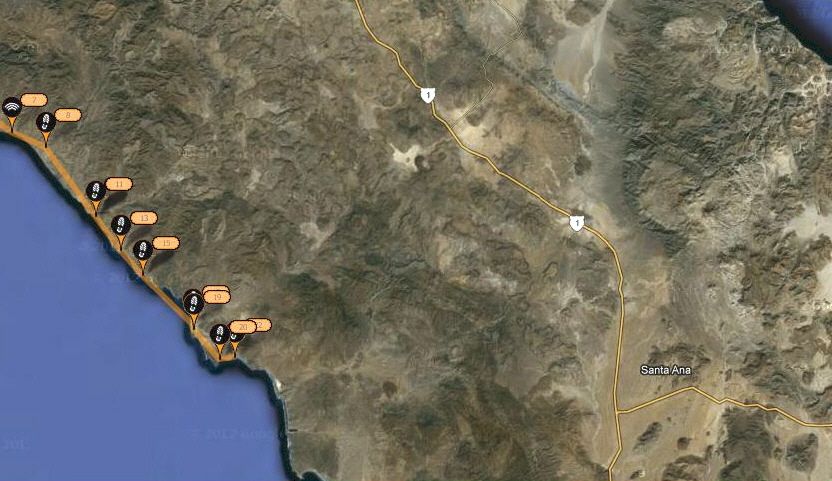
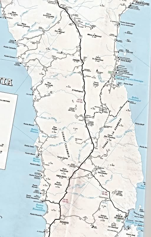
Here's the overall 'remote' Pacific coast area(7 Sisters):


micah202 - 3-10-2013 at 11:40 AM

Quote:
Originally posted by David K
That's why it's an adventure... you don't know what you will find!
There are fish camps, but may not be occupied or be able to help.
Here's the overall 'remote' Pacific coast area(7 Sisters):


....looking like they're through the mostest of whatever isolation there was,,,not so far from the other end,,,and more active roadways,settlements soon


''That's why it's an adventure... you don't know what you will find!''...........life is like a box of chocolates,,,,
........yah,,but if what you find is habitation,hospitality each night,,then the adventure changes!....I imagine by now they've had to be self reliant at least a bit(?)

...their F.B. note leaves me wondering


.


[Edited on 3-10-2013 by micah202]

David K - 3-10-2013 at 11:43 AM

Quote:
Originally posted by micah202
Quote:
Originally posted by David K
That's why it's an adventure... you don't know what you will find!
There are fish camps, but may not be occupied or be able to help.
Here's the overall 'remote' Pacific coast area(7 Sisters):


....looking like they're through the mostest of whatever isolation there was,,,not so far from the other end,,,and more active roadways,settlements soon


.

[Edited on 3-10-2013 by micah202]


Not yet, they are in the middle of the Sisters, and if they hug the coast, there are still days of not seeing others ahead of them.

micah202 - 3-10-2013 at 11:48 AM

Quote:
Originally posted by David K
Quote:
Originally posted by micah202
Quote:
Originally posted by David K
That's why it's an adventure... you don't know what you will find!
There are fish camps, but may not be occupied or be able to help.
Here's the overall 'remote' Pacific coast area(7 Sisters):


....looking like they're through the mostest of whatever isolation there was,,,not so far from the other end,,,and more active roadways,settlements soon


.


Not yet, they are in the middle of the Sisters, and if they hug the coast, there are still days of not seeing others ahead of them.


.........looking like 2/3 way,,,,coming up to a section I've labeled 'lost-coast' from nomad stories

are you able to plot their course on that larger map with dates??...hard to get perspective otherwise!:wow:

[Edited on 3-10-2013 by micah202]

David K - 3-10-2013 at 12:02 PM

Quote:
Originally posted by micah202
Quote:
Originally posted by David K
Quote:
Originally posted by micah202
Quote:
Originally posted by David K
That's why it's an adventure... you don't know what you will find!
There are fish camps, but may not be occupied or be able to help.
Here's the overall 'remote' Pacific coast area(7 Sisters):


....looking like they're through the mostest of whatever isolation there was,,,not so far from the other end,,,and more active roadways,settlements soon


.


Not yet, they are in the middle of the Sisters, and if they hug the coast, there are still days of not seeing others ahead of them.


are you able to plot their course on that larger map with dates??...hard to get perspective otherwise!:wow:


I am not going to, but you can look at this thread an see where they were on different days.

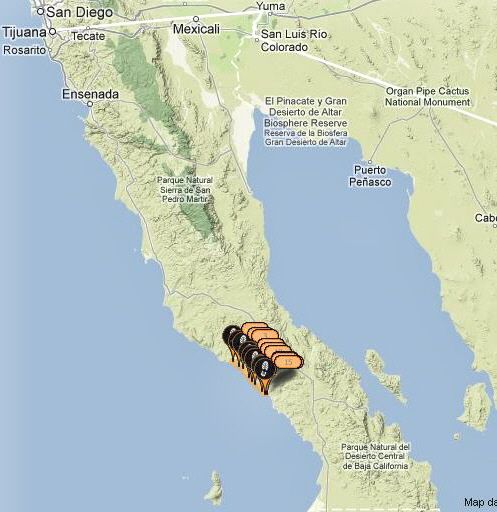
The SPOT map only keeps the latest 50 or so Spot signals, so here is the map of Baja California state (Norte) and there most recent signals, to yesterday (I didn't see a new one since yesterday morning):


I hope this helps you and anyone else see the area they are in or how far they have walked since leaving Tijuana!

micah202 - 3-10-2013 at 12:09 PM

...thanks david,,that does help!

......looking like 2/3 way,,,,coming up to a section I've labeled 'lost-coast' on my road-map,,from nomad surf-stories


[Edited on 3-10-2013 by micah202]

luv2fish - 3-10-2013 at 03:45 PM

Quote:
Originally posted by David K
That's why it's an adventure... you don't know what you will find!
There are fish camps, but may not be occupied or be able to help.
Here's the overall 'remote' Pacific coast area(7 Sisters):


Hi Dave, had a quick question, Are there two cities in Baja named Rosarito or is this maybe a typo ?? Thanks

Bajaboy - 3-10-2013 at 03:56 PM

Quote:
Originally posted by luv2fish
Quote:
Originally posted by David K
That's why it's an adventure... you don't know what you will find!
There are fish camps, but may not be occupied or be able to help.
Here's the overall 'remote' Pacific coast area(7 Sisters):


Hi Dave, had a quick question, Are there two cities in Baja named Rosarito or is this maybe a typo ?? Thanks


Yes except one is not a city...instead a small village.

David K - 3-10-2013 at 04:34 PM

As Bajaboy said, "Rosarito" is a small village... The city near Tijuana is officially Playas de Rosarito (Rosarito Beach) I do believe. However, the village of Rosarito on the map is sometimes called 'Nuevo Rosarito' as a way of being unique.

There are many places with the same name in Baja... most are ranchos or farm towns... Spanish and Catholic names just has so many words available.

[Edited on 3-10-2013 by David K]

DianaT - 3-10-2013 at 04:41 PM

Quote:
Originally posted by David K
As Bajaboy said, "Rosarito" is a small village... The city near Tijuana is officially Playas de Rosarito (Rosarito Beach) I do believe. However, the village of Rosarito on the map is sometimes called 'Nuevo Rosarito' as a way of being unique.

There are many places with the same name in Baja... most are ranchos or farm towns... Spanish and Catholic names just has so many words available.

[Edited on 3-10-2013 by David K]


There are two distinct Rosaritos down south if one is to believe the signs. There is Rosarito and Nuevo Rosarito --- close together, but with separate signs.

[Edited on 3-10-2013 by DianaT]

David K - 3-10-2013 at 04:52 PM

You mean at the same village? Perhaps a newer sign and an older sign?

rts551 - 3-10-2013 at 05:03 PM

If you look at the Almanac you will see there are two different towns.

David K - 3-10-2013 at 06:23 PM

Quote:
Originally posted by rts551
If you look at the Almanac you will see there are two different towns.


LOL yup... in the new one (2009) they just have a black sqaure (like a rancho)... On the north side of the arroyo is Nuevo Rosarito, and on the south side is another square listed as just Rosarito...

In the 2003, larger scale Almanac, it is just one town and shown as a town, not a rancho... called Rosarito.

I can tell you that there were buildings on both sides of that arroyo at the same time, back when Hwy. 1 was built through it in '73.... so to say one side is 'New' and not the other is funny. I bet Landon or the cartographers in D.F. were just trying to show it both ways.

However, the north side may be newer... I just don't remember it that well when we drove through in 1967, only that it was multiple homes and not a single ranch... and mostly or entirely on the south side, where the San Borja road comes in.

DianaT - 3-10-2013 at 06:59 PM

Quote:
Originally posted by David K
You mean at the same village? Perhaps a newer sign and an older sign?


No

David K - 3-10-2013 at 07:33 PM

No? ... then where is this other Rosarito if not the same one?

edit: I had two questions, but you only gave one answer... so I am not sure what you said no to.

[Edited on 3-11-2013 by David K]

rts551 - 3-10-2013 at 09:18 PM

So you dispute the map writers and the signs on each side of the arroyo? By the way, the legend in the map (inside front cover) does not say Ranch...a small square only means a town of less than 200. A rancho is a small circle. And it really is not relevant what the place was like 40 years ago.

Quote:
Originally posted by David K
Quote:
Originally posted by rts551
If you look at the Almanac you will see there are two different towns.


LOL yup... in the new one (2009) they just have a black sqaure (like a rancho)... On the north side of the arroyo is Nuevo Rosarito, and on the south side is another square listed as just Rosarito...

In the 2003, larger scale Almanac, it is just one town and shown as a town, not a rancho... called Rosarito.

I can tell you that there were buildings on both sides of that arroyo at the same time, back when Hwy. 1 was built through it in '73.... so to say one side is 'New' and not the other is funny. I bet Landon or the cartographers in D.F. were just trying to show it both ways.

However, the north side may be newer... I just don't remember it that well when we drove through in 1967, only that it was multiple homes and not a single ranch... and mostly or entirely on the south side, where the San Borja road comes in.

David K - 3-11-2013 at 01:38 AM

You are correct Ralph, thank you.

micah202 - 3-11-2013 at 10:49 AM

.......a -bit- more news on facebook,,,amazing there's that much internet in such 'isolation'.........better than Gonzaga bay was in feb!!............

WHAT IS WEST
15 hours ago.
Santo Tomas. Miguel uses a lighter to show us the walls of his casita made from adobe. He invited us into his home after we walked for a day and a half along the carretera (highway) through the mountains. Nothing is more jarring than walking narrow mountain roads traveled by semi-trucks and we were beyond grateful for his offer for us to stay. In return we honored his request for a few cigarettes and Viva Villa, a 3 dollar bottle of cheap fake tequila. He wasn't satisfied though until we promised we'd return with our friends and stay in his casita.


.

[Edited on 3-11-2013 by micah202]

David K - 3-11-2013 at 11:58 AM

Last night, the boys sent a new Spot signal... about 2 miles north of Punta Cono.

See their location: http://www.whatiswest.com/where-are-we/

BajaGeoff - 3-11-2013 at 03:06 PM

Got back late last night from San Felipe....internet access was really bad most of the trip, so I was not able to do any updates. Here is a recap of the last week of the walk...from the area between Punta Canoas and Punta Coño...they are not moving very fast so I have to assume the surf has been really good down there!


TMW - 3-11-2013 at 04:15 PM

Geoff when or if you make contact with them could you ask them if they saw any road work being done north of Bahia Blanco toward the east. The guy that lives at the turn off to Cocos on Hwy1 told me they were going to build a road, assume graded, from his area to the ocean for the rock trucks hauling ornamental rocks.

whatiswest - 3-11-2013 at 05:05 PM

Hey nomads I am about to head down on Tuesday and meet the guys for a quick surf session near Punta Prieta. I'll be back Sunday with photos and updates. I'll be sure to pass along all the Baja Nomad love.
-Bryan F (guy who has been updating all their social media while they are on the trip)

DENNIS - 3-11-2013 at 05:08 PM

Quote:
Originally posted by whatiswest
Hey nomads I am about to head down on Tuesday and meet the guys for a quick surf session near Punta Prieta. I'll be back Sunday with photos and updates. I'll be sure to pass along all the Baja Nomad love.
-Bryan F (guy who has been updating all their social media while they are on the trip)


Thanks, Bryan. Give them our best cheer of support.

BajaGeoff - 3-11-2013 at 05:41 PM

Quote:
Originally posted by whatiswest
Hey nomads I am about to head down on Tuesday and meet the guys for a quick surf session near Punta Prieta. I'll be back Sunday with photos and updates. I'll be sure to pass along all the Baja Nomad love.
-Bryan F (guy who has been updating all their social media while they are on the trip)


Awsome Bryan! Have a great trip....can't wait for an update...

Ateo - 3-11-2013 at 05:44 PM

TW: my buddy was down there last month and said a rancher told him they cut a new road in in that area but I don't know where. Sorry.

Bryan: Tell the guys that no one is being a jerk on Baja Nomad in their thread! =)

woody with a view - 3-11-2013 at 06:25 PM

Quote:
Originally posted by BajaGeoff
Got back late last night from San Felipe....internet access was really bad most of the trip, so I was not able to do any updates. Here is a recap of the last week of the walk...from the area between Punta Canoas and Punta Coño...they are not moving very fast so I have to assume the surf has been really good down there!


lotta magic happens in there where the road swings away from the coast. i hope they don't spoil it and spill the beans, er, secrets!

micah202 - 3-12-2013 at 11:41 AM

Quote:
Originally posted by woody with a view


lotta magic happens in there where the road swings away from the coast. i hope they don't spoil it and spill the beans, er, secrets!


........ahhh,,legends of the lost coast!
.....guess it's -over- once the highway's in;D

...wow,,another update from facebook,,amazing!......''

WHAT IS WEST

20 hours ago. From Santo Tomas to the coast. The dirt roads inevitably take you through ranches where cattle graze. To continue on the road there is usually a gate made of barbed wire and wooden poles. A small piece of rope acts as a hinge and when its unhooked the entire gate swings wildly and collapses in the dirt. After passing through the gate of Rancho Los Alisos, we came upon the ranch home snuggled amongst orange trees. "Buenas tardes"! (Good afternoon) we yelled to the house. After a couple minutes a tall blue-eyed Mexican with gray hair came out to greet us. He invited us in the house for lunch that his wife prepared on the spot. Beans and home-made tortillas never get old, wash that down with some lukewarm Coke. Conversation was kind of difficult between bean slurps. Such amazing hospitality displayed, and we are forever grateful.

..........................................

......have these lads cooked a meal -YET???????????/:o:P:P

[Edited on 3-12-2013 by micah202]

BajaGeoff - 3-13-2013 at 09:51 AM

Here is the walk from the last two days. The dudes are now about 20 miles south of Punta Coño...they should be getting into Baja Sur within the next week or so!


[Edited on 3-13-2013 by BajaGeoff]

David K - 3-13-2013 at 02:41 PM

Looks like they a close to Punta Rocosa, and walking along the coast, where this no road, at that! Less than 10 miles to Santa Rosalillita...

BajaNomad - 3-14-2013 at 12:38 AM

From their FB page - posted about an hour ago:

--------------
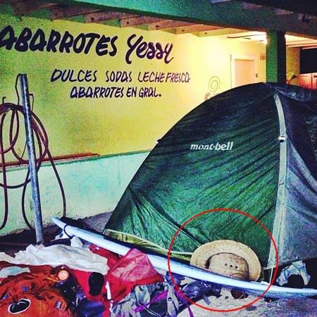
Urban camping tonight outside of the only mini-mercado in town. Made it to Santa Rosalillita! Nearly 200 miles of coast conquered and plenty to report on. Many say this is the least inhabited stretch of coast in all of Baja. In those 200 miles we encountered no more than 50 people - mostly fisherman and a few surfers from Canada and the US. More to come!
--------------


http://www.facebook.com/WHATISWEST

mcfez - 3-14-2013 at 08:28 AM

These two guys are a little strange. Who takes their three eye Teddy Bear along for a walking trip?

;)


BajaGeoff - 3-14-2013 at 09:39 AM

Hahahaha mcfez!

Here is the map as of this morning with their location at Santa Rosalillita. It doesn't look like their Spot pinged their location from yesterday's walk...


mtgoat666 - 3-14-2013 at 09:46 AM

Quote:
Originally posted by mcfez
These two guys are a little strange. Who takes their three eye Teddy Bear along for a walking trip?

;)


and who camps next to a mini mart? :lol::lol:

i suppose if you have a hankering for chips and pop tarts and coke, good to camp where food is just 10 feet away :lol::lol:

BajaGeoff - 3-14-2013 at 10:40 AM

It's likely the first real store they have seen in weeks....probably since they left El Rosario on February 22nd!

micah202 - 3-14-2013 at 10:42 AM

Quote:
Originally posted by mtgoat666

and who camps next to a mini mart? :lol::lol:

:


.....yer can't have more smokes till you make it to the mercado!!

Curt63 - 3-14-2013 at 12:50 PM

Sometimes in Baja the wind kicks up.

Windbreak?

Congratulations, Guys!!

EnsenadaDr - 3-17-2013 at 04:37 PM

I love Justin's and Bryan's attitude, "It's all about the experience." Not who has the most knowledge, or the greatest strength; who can hike 20 miles a day. Life is all about what makes you happy. There are many critics out there; many who want to tear down the pioneer spirit in not only themselves, but in the young and young at heart. Glad to see Justin and Bryan posting for National Geographic Explorers' Journal.

http://newswatch.nationalgeographic.com/2013/03/15/suburbs-t...

You go, guys!!

David K - 3-17-2013 at 04:41 PM

Too bad the second photo in that NatGeo link is a town trash dump, somewhere... but I guess that is Baja, too!??? Thanks Dra. for the post!

DENNIS - 3-17-2013 at 05:09 PM

Quote:
Originally posted by David K
Too bad the second photo in that NatGeo link is a town trash dump, somewhere


Yeah....what's up with that? What are they trying to say? It's not like all communities down here have a fat tax base to deal with everything.
I know the "Green" ideal is somewhat new here, but initiatives take money and reeducation as well as time.
It ain't Orange County.

EnsenadaDr - 3-17-2013 at 05:12 PM

I myself would trying to say that the Mexican government should be using the milliones of pesos fixing the trash problem instead of repaving the Carretera between Tijuana and Ensenada every three months. They could put sewage and proper waste disposal facilities into action along the roads. I have been wondering why the same stretch of highway gets the bulk of the toll dollars (and they ain't cheap either!!) every few months for the past 10 years.

[Edited on 3-18-2013 by EnsenadaDr]

DENNIS - 3-17-2013 at 05:21 PM

Quote:
Originally posted by EnsenadaDr
I myself would trying to say that the Mexican government should be using the milliones of pesos fixing the trash problem instead of repaving the Carretera between Tijuana and Ensenada every three months. They could put sewage and proper waste disposal facilities into action along the roads. I have been wondering why the same stretch of highway gets the bulk of the toll dollars (and they ain't cheap either!!) every few months for the past 10 years.


The area of most concern, just north of the Ensenada Toll Plaza, is a geoligic falt zone and continues to want to slide toward the water, so they have to keep at it or lose it.

They shouldn't even consider using toll revenue for various needs. When they start doing that, the road condition will be secondary.....at best.

EnsenadaDr - 3-17-2013 at 05:27 PM

I'm not talking just about that part of the road, Dennis, I am talking about all the reconstruction in other parts of the road, such as near Calafia that has been redone over the years, over and over and over. And you want more tourism dollars? I think the boys' are sending out a great message. Clean this crap up or no one will want to visit. It will bring a lot of needed attention to Baja. Again, their message isn't totally negative. They have some beautiful pictures in their Facebook collection. But it's time Mexico steps up to the plate and starts putting in sewage in areas and sanitation in areas such as Zorillo. I remember the water ponds I had to drive to work in every day, due to septics overflowing on the hills from the houses, down to the ravines and into the streets. Kids walking through these sewage lakes..and getting their shoes soaking wet. I called the Secretaria de Salud a few times, but, it's just "the way it is", they told me.

[Edited on 3-18-2013 by EnsenadaDr]

DENNIS - 3-17-2013 at 05:45 PM

Quote:
Originally posted by EnsenadaDr

Clean this crap up or no one will want to visit.


Yeah....that's it. Wouldn't want to upset all those tourists on the big Baja town dump tour.


Quote:

But it's time Mexico steps up to the plate and starts putting in sewage in areas and sanitation in areas such as Zorillo. I remember the water ponds I had to drive to work in every day, due to septics overflowing on the hills from the houses, down to the ravines and into the streets. Kids walking through these sewage lakes..and getting their shoes soaking wet. I called the Secretaria de Salud a few times, but, it's just "the way it is", they told me.


Zorillo is a squatters colony. Where is the money supposed to come from for all the upgrades? Would it be fair to take tax Pesos from Maneadero to fix the place? I doubt it. They still have too many dirt roads right in Centro.

EnsenadaDr - 3-17-2013 at 06:50 PM

You forget how many people Dennis want to drive from TJ to Cabo or even to Bahia de Los Angeles....it certainly isn't appetizing to see all the trash from the sides of the road. I saw the same thing about 7 years ago. I was on a cruise ship from San Diego to Acapulco. I got it into my head to drive (about 5 hours) to the silver town of Taxco. I had this "romantic" dream about the beautiful scenery, and there was plastic and toilet paper littered all along the route. To attract more tourists, people need to at least start putting trash in receptacles, so are you saying that the road tolls couldn't be used for trash receptacles every few kilometers?

DENNIS - 3-17-2013 at 07:02 PM

Quote:
Originally posted by EnsenadaDr
so are you saying that the road tolls couldn't be used for trash receptacles every few kilometers?


I think trash cans at the Toll Plazas is sufficient. People who use such things probably won't litter and those who do litter won't stop to use a can. Look what happens on the beaches. Trash everywhere and empty trash cans.

You can't litter aluminum. :lol:

EnsenadaDr - 3-17-2013 at 08:12 PM

I don't think there are any toll booths south of Ensenada...you mean no more garbage containers all the way to Cabo???:wow:

[Edited on 3-18-2013 by EnsenadaDr]

DENNIS - 3-18-2013 at 08:01 AM

Who's going to empty the trash cans? Every one of them would be the beginning of the scenario in the foto that started this discussion.
OK....back to our original programming.

tripledigitken - 3-18-2013 at 08:08 AM

Looks like any dump.

vandenberg - 3-18-2013 at 08:35 AM

Trash cans by themselves don't help the litter problem. In BCS most roadside cans are overflowing without any sign of ever getting emptied. And all the overflow blows down the highway/desert.

"five areas of interest?"

mtgoat666 - 3-18-2013 at 10:38 AM

Quote:
Originally posted by DENNIS
Quote:
Originally posted by David K
Too bad the second photo in that NatGeo link is a town trash dump, somewhere


Yeah....what's up with that? What are they trying to say? It's not like all communities down here have a fat tax base to deal with everything.
I know the "Green" ideal is somewhat new here, but initiatives take money and reeducation as well as time.
It ain't Orange County.


the landfill photo is one reality, seems to fit w/in their mission statement.

according to the natgeo web mention, the walkers stated: "we are on a mission to explore and document Mexico’s Baja peninsula in the name of conservation... we have targeted five areas of interest and will address overarching ecological issues relevant to the region. Over the course of our 1000+ mile journey we will reveal through our lens why Baja has been deemed important to conserve and if there’s anything further to be done."

always nice to have a new photo record of natural places pristine, threatened, and already damaged. but comprehensive presentation to "address overarching ecological issues relevant to the region" may take a lot of research separate from walking and photographing,...

i am wondering what are the specific "five areas of interest" mentioned in the mission statement?
anybody know?

[Edited on 3-18-2013 by mtgoat666]

BajaGeoff - 3-18-2013 at 12:02 PM

I don't know the specific five areas mtgoat....I am sure they will chime in once they get to Guerrero Negro. They were on the move again yesterday.....and now a few miles south of Miller's Landing:


[Edited on 3-18-2013 by BajaGeoff]

David K - 3-18-2013 at 12:05 PM

Thank you Geoff!

EnsenadaDr - 3-19-2013 at 01:05 AM

I'm sure that finding new sources of water would be on the list, and a Professor of Hydrology might be of assistance at this time, Goat!
Quote:
Originally posted by mtgoat666
Quote:
Originally posted by DENNIS
Quote:
Originally posted by David K
Too bad the second photo in that NatGeo link is a town trash dump, somewhere


Yeah....what's up with that? What are they trying to say? It's not like all communities down here have a fat tax base to deal with everything.
I know the "Green" ideal is somewhat new here, but initiatives take money and reeducation as well as time.
It ain't Orange County.


the landfill photo is one reality, seems to fit w/in their mission statement.

according to the natgeo web mention, the walkers stated: "we are on a mission to explore and document Mexico’s Baja peninsula in the name of conservation... we have targeted five areas of interest and will address overarching ecological issues relevant to the region. Over the course of our 1000+ mile journey we will reveal through our lens why Baja has been deemed important to conserve and if there’s anything further to be done."

always nice to have a new photo record of natural places pristine, threatened, and already damaged. but comprehensive presentation to "address overarching ecological issues relevant to the region" may take a lot of research separate from walking and photographing,...

i am wondering what are the specific "five areas of interest" mentioned in the mission statement?
anybody know?

[Edited on 3-18-2013 by mtgoat666]
:spingrin::spingrin::spingrin:

whatiswest - 3-19-2013 at 10:17 PM

We gave natgeo a batch of photos and those are the ones they chose. Sadly, we've seen a lot of trash on our trip. there just simply doesnt exist the same cultural value of tidyness. We try to minimize our impact by burning or packing out trash. But bringing your trash to a can in el Rosario doesn't mean it'll be dealt with the American way- outta sight outta mind, new housing community built on top.

Also, sorry to report we haven't caught a single fish, though I only tried once. We ate the bait instead;)

We're about to begin a major chapter of the trip: la peninsula vizcaino. Cave art and whales, salt flats and ranches.
Thank you David k for posting our progress!

Micah- what exactly is your connection to Baja? Now that we're "bonafied", we perhaps deserve some explanation or apology for your crudeness.

micah202 - 3-19-2013 at 11:42 PM

Quote:
Originally posted by whatiswest


Micah- what exactly is your connection to Baja? Now that we're "bonafied", we perhaps deserve some explanation or apology for your crudeness.


......... good to see you've made it through that rougher section,,REALLY!!......it'd be good to get some more details such as wether you got some good surfing?....how it was for you in the more isolated area,,,REALLY!!!

......you must realize that when you fundraise you become something of a public entity,,,,and set yourself up for some criticism or even ridicule,,,,,, so rather than apologise,I say -you're welcome-for helping keep things real!
......you said you were going to refrain from vehicular transit,,,and the first miles of your adventure were in a car,,,while your blog said otherwise--it was good to see you corrected that on your blog when I pointed out the contradiction!,,,good to keep it real.
........the whole speel for the trek seemed to highlight the remote adventure aspects of the trip,,,and surely that's what you were expecting judging by the survival gear you've been carrying,,,,,but this was contrasted with the first section being down the highway,,casita to casita....
.....methinks it's unfortunate that communications have been the way they have been,,,where of course we get much more details of the populated stretch than the MUCH more interesting remote section.....it'd be great to hear more details of that isolated stretch,,somewhere I KNOW at my age I'll not get there!.....I'm sure there was adventure and adversity,,,you had to make it through some harder times on your own cajones(??),,,,make some water(??),,,or not.
.........I REALLY appreciate it when you acknowledge the differences between your expectations and the realities of the trip,,and fully acknowledge those that help,,and how much you rely on them at times

......you said it yourself in a video,,the criticism makes you more determined!!! !


[Edited on 3-20-2013 by micah202]

Phony...let's call a spade a spade

EnsenadaDr - 3-20-2013 at 04:42 AM

The rudeness comes from a guy who ONLY appears to travel the Baja in comfort...I was hoping you guys would have caught the posting I put on Graham's thread...Mr. Micah it seems, is passionate about Baja, alright, but only with his Toyota packed to the gills with creature comforts, read here:

Originally posted by EnsenadaDr
Micah202's post from a trip about a year ago..

.by micah202 » Tue Dec 27, 2011 10:57 am
...mann,,busy times,,,,,got the insulation & panelling in,,,,general grabber's on,,,bed/box/bin built in,,,,stereo mounted,,,,3 way cooler going,,,rack's on..kayak & kiteboard mounted.....co-drivers lined up and ready................

For someone who purportedly "roughs it" looks like he really pads his wheels with comfort for the ride into Baja..sounds like this guy travels in style...follow his trip comments on ToyotaVanPeople, really roughing it, aren't you Micah??

http://www.toyotavanpeople.com/forum/viewtopic.php?f=6&t...


Quote:
Originally posted by whatiswest
We gave natgeo a batch of photos and those are the ones they chose. Sadly, we've seen a lot of trash on our trip. there just simply doesnt exist the same cultural value of tidyness. We try to minimize our impact by burning or packing out trash. But bringing your trash to a can in el Rosario doesn't mean it'll be dealt with the American way- outta sight outta mind, new housing community built on top.

Also, sorry to report we haven't caught a single fish, though I only tried once. We ate the bait instead;)

We're about to begin a major chapter of the trip: la peninsula vizcaino. Cave art and whales, salt flats and ranches.
Thank you David k for posting our progress!

Micah- what exactly is your connection to Baja? Now that we're "bonafied", we perhaps deserve some explanation or apology for your crudeness.


[Edited on 3-20-2013 by EnsenadaDr]

EnsenadaDr - 3-20-2013 at 05:05 AM

By the way, I was curious as to what a 3 cooler system was, not much to my surprise was a cooler for an XBox 360!!!

tripledigitken - 3-20-2013 at 05:26 AM

Dr,

It's a 3 way powered fridge.

12v, 120v, or propane. Very common in RV's.

Ken

EnsenadaDr - 3-20-2013 at 05:46 AM

sounds like this guy is hooked up...refrigeration, stereo, wheels, plenty of food..

mtgoat666 - 3-20-2013 at 05:56 AM

Quote:
Originally posted by micah202
Quote:
Originally posted by whatiswest


Micah- what exactly is your connection to Baja? Now that we're "bonafied", we perhaps deserve some explanation or apology for your crudeness.


......... good to see you've made it through that rougher section,,REALLY!!......it'd be good to get some more details such as wether you got some good surfing?....how it was for you in the more isolated area,,,REALLY!!!

......you must realize that when you fundraise you become something of a public entity,,,,and set yourself up for some criticism or even ridicule,,,,,, so rather than apologise,I say -you're welcome-for helping keep things real!
......you said you were going to refrain from vehicular transit,,,and the first miles of your adventure were in a car,,,while your blog said otherwise--it was good to see you corrected that on your blog when I pointed out the contradiction!,,,good to keep it real.
........the whole speel for the trek seemed to highlight the remote adventure aspects of the trip,,,and surely that's what you were expecting judging by the survival gear you've been carrying,,,,,but this was contrasted with the first section being down the highway,,casita to casita....
.....methinks it's unfortunate that communications have been the way they have been,,,where of course we get much more details of the populated stretch than the MUCH more interesting remote section.....it'd be great to hear more details of that isolated stretch,,somewhere I KNOW at my age I'll not get there!.....I'm sure there was adventure and adversity,,,you had to make it through some harder times on your own cajones(??),,,,make some water(??),,,or not.
.........I REALLY appreciate it when you acknowledge the differences between your expectations and the realities of the trip,,and fully acknowledge those that help,,and how much you rely on them at times

......you said it yourself in a video,,the criticism makes you more determined!!! !


[Edited on 3-20-2013 by micah202]


The guys are self promoters, pt Barnum travelers, looking for benefactors to pay for their jaunt, and speaking in hash tags. They are fair game. If they want peace and quiet they should stay off twitter, Instagram, Facebook, nomad, and the half dozen other media they blog on

P.s. I think their trip is great. I think criticism is great.

mtgoat666 - 3-20-2013 at 05:58 AM

Quote:
Originally posted by mtgoat666
Quote:
Originally posted by DENNIS
Quote:
Originally posted by David K
Too bad the second photo in that NatGeo link is a town trash dump, somewhere


Yeah....what's up with that? What are they trying to say? It's not like all communities down here have a fat tax base to deal with everything.
I know the "Green" ideal is somewhat new here, but initiatives take money and reeducation as well as time.
It ain't Orange County.


the landfill photo is one reality, seems to fit w/in their mission statement.

according to the natgeo web mention, the walkers stated: "we are on a mission to explore and document Mexico’s Baja peninsula in the name of conservation... we have targeted five areas of interest and will address overarching ecological issues relevant to the region. Over the course of our 1000+ mile journey we will reveal through our lens why Baja has been deemed important to conserve and if there’s anything further to be done."

always nice to have a new photo record of natural places pristine, threatened, and already damaged. but comprehensive presentation to "address overarching ecological issues relevant to the region" may take a lot of research separate from walking and photographing,...

i am wondering what are the specific "five areas of interest" mentioned in the mission statement?
anybody know?


Still waiting to hear what are the five areas of interest?

EnsenadaDr - 3-20-2013 at 06:08 AM

Criticism is great, Goat, but you must also consider the source. Coming from a guy like Micah who bragged about his hiking skills and wilderness aptitude, and then finding out he travels in the luxury liner on wheels of Baja...well that doesn't set too well with me. The five interests? Hydrology, Hydrology, Hydrology, Hydrology...and excess trash...you know potable water is a big problem in Baja!!
Quote:
Originally posted by mtgoat666
Quote:
Originally posted by micah202
Quote:
Originally posted by whatiswest


Micah- what exactly is your connection to Baja? Now that we're "bonafied", we perhaps deserve some explanation or apology for your crudeness.


......... good to see you've made it through that rougher section,,REALLY!!......it'd be good to get some more details such as wether you got some good surfing?....how it was for you in the more isolated area,,,REALLY!!!

......you must realize that when you fundraise you become something of a public entity,,,,and set yourself up for some criticism or even ridicule,,,,,, so rather than apologise,I say -you're welcome-for helping keep things real!
......you said you were going to refrain from vehicular transit,,,and the first miles of your adventure were in a car,,,while your blog said otherwise--it was good to see you corrected that on your blog when I pointed out the contradiction!,,,good to keep it real.
........the whole speel for the trek seemed to highlight the remote adventure aspects of the trip,,,and surely that's what you were expecting judging by the survival gear you've been carrying,,,,,but this was contrasted with the first section being down the highway,,casita to casita....
.....methinks it's unfortunate that communications have been the way they have been,,,where of course we get much more details of the populated stretch than the MUCH more interesting remote section.....it'd be great to hear more details of that isolated stretch,,somewhere I KNOW at my age I'll not get there!.....I'm sure there was adventure and adversity,,,you had to make it through some harder times on your own cajones(??),,,,make some water(??),,,or not.
.........I REALLY appreciate it when you acknowledge the differences between your expectations and the realities of the trip,,and fully acknowledge those that help,,and how much you rely on them at times

......you said it yourself in a video,,the criticism makes you more determined!!! !


[Edited on 3-20-2013 by micah202]


The guys are self promoters, pt Barnum travelers, looking for benefactors to pay for their jaunt, and speaking in hash tags. They are fair game. If they want peace and quiet they should stay off twitter, Instagram, Facebook, nomad, and the half dozen other media they blog on

P.s. I think their trip is great. I think criticism is great.

mtgoat666 - 3-20-2013 at 06:25 AM

Quote:
Originally posted by EnsenadaDr
Criticism is great, Goat, but you must also consider the source. Coming from a guy like Micah who bragged about his hiking skills and wilderness aptitude, and then finding out he travels in the luxury liner on wheels of Baja...well that doesn't set too well with me. The five interests? Hydrology, Hydrology, Hydrology, Hydrology...and excess trash...you know potable water is a big problem in Baja!!
Quote:
Originally posted by mtgoat666
Quote:
Originally posted by micah202
Quote:
Originally posted by whatiswest


Micah- what exactly is your connection to Baja? Now that we're "bonafied", we perhaps deserve some explanation or apology for your crudeness.


......... good to see you've made it through that rougher section,,REALLY!!......it'd be good to get some more details such as wether you got some good surfing?....how it was for you in the more isolated area,,,REALLY!!!

......you must realize that when you fundraise you become something of a public entity,,,,and set yourself up for some criticism or even ridicule,,,,,, so rather than apologise,I say -you're welcome-for helping keep things real!
......you said you were going to refrain from vehicular transit,,,and the first miles of your adventure were in a car,,,while your blog said otherwise--it was good to see you corrected that on your blog when I pointed out the contradiction!,,,good to keep it real.
........the whole speel for the trek seemed to highlight the remote adventure aspects of the trip,,,and surely that's what you were expecting judging by the survival gear you've been carrying,,,,,but this was contrasted with the first section being down the highway,,casita to casita....
.....methinks it's unfortunate that communications have been the way they have been,,,where of course we get much more details of the populated stretch than the MUCH more interesting remote section.....it'd be great to hear more details of that isolated stretch,,somewhere I KNOW at my age I'll not get there!.....I'm sure there was adventure and adversity,,,you had to make it through some harder times on your own cajones(??),,,,make some water(??),,,or not.
.........I REALLY appreciate it when you acknowledge the differences between your expectations and the realities of the trip,,and fully acknowledge those that help,,and how much you rely on them at times

......you said it yourself in a video,,the criticism makes you more determined!!! !


[Edited on 3-20-2013 by micah202]


The guys are self promoters, pt Barnum travelers, looking for benefactors to pay for their jaunt, and speaking in hash tags. They are fair game. If they want peace and quiet they should stay off twitter, Instagram, Facebook, nomad, and the half dozen other media they blog on

P.s. I think their trip is great. I think criticism is great.


Micah is a guy who planned a long trip in baja and his van was stolen in first day in tj. I don't know if he ever went back to Baja. I think he is Canuck, perhaps explains all,... :lol:

P.s. water is not a prob in Baja. People made their own problem when they decided to live in desert. People just chose a challenge.

[Edited on 3-20-2013 by mtgoat666]

micah202 - 3-20-2013 at 11:06 AM

Quote:
Originally posted by mtgoat666


The guys are self promoters, pt Barnum travelers, looking for benefactors to pay for their jaunt, and speaking in hash tags. They are fair game. If they want peace and quiet they should stay off twitter, Instagram, Facebook, nomad, and the half dozen other media they blog on

P.s. I think their trip is great. I think criticism is great.


....EXACTLY!!!!
....."Doctor',,,you can be a fanboy all you want,,,
,,,but to try and thread-police with your thin wit is best described as ludicrous,,,,,,do you really expect that everyone should act -your- way???:lol::lol:

EnsenadaDr - 3-20-2013 at 11:14 AM

You know what Micah, I think Dale Carnegie is looking for a man like you.

micah202 - 3-20-2013 at 11:56 AM

...'doctor' ,,I have trouble figuring out what your problem really is!?
.....my comments on this thread have been a healthy balance of criticism and encouragement,,,,,I do REALLY want to hear more details of their trip through the remote areas I will never get to.
....I think it is great when they respond to feedback-it makes their program stronger.

...personally,,I'm in my fifties now,,,am active with small sailboats,,,hence the 'luxury' '86 toyota van:tumble:
.....what I do ,or -have- done is not relevant to this or any thread,,as I have never solicited public funds for my junkets!!!

EnsenadaDr - 3-20-2013 at 12:41 PM

Please have respect for this thread. You have made your position known. Let's get back to hearing about the boys' journey.

motoged - 3-20-2013 at 12:52 PM

Quote:
Originally posted by mtgoat666
I think he is Canuck, perhaps explains all,... :lol:....


Goat,
I know you were jokin'.....but you don't want to play that card....do ya? ;D:biggrin:

paranewbi - 3-20-2013 at 02:18 PM

"They are fair game. If they want peace and quiet they should stay off twitter, Instagram, Facebook, nomad, and the half dozen other media they blog on" (micah202)

Really? Are you from the stone(d) age?

"...personally,,I'm in my fifties now,,,am active with small sailboats,,,hence the 'luxury' '86 toyota van" (micah202)

Woops, should have read that last part first!

"methinks it's unfortunate that communications have been the way they have been,,,where of course we get much more details of the populated stretch than the MUCH more interesting remote section.....it'd be great to hear more details of that isolated stretch,,somewhere I KNOW at my age I'll not get there!....." (micah202)

Oh yea, this shouldn't be like in the old days when those movie previews left you wanting to see the final production. These guys should be stupid and tell us every little detail with full color pix so they can screw the people they have made arraingments with.

"Micah- what exactly is your connection to Baja? Now that we're "bonafied", we perhaps deserve some explanation or apology for your crudeness." (whatiswest)

Don't bother boys, you aren't going to get one. You see things differantly than some and some are just bothered that your seeing things.

micah202 - 3-20-2013 at 08:38 PM

Quote:
Originally posted by EnsenadaDr
Please have respect for this thread. You have made your position known. Let's get back to hearing about the boys' journey.


...that's about the first thing you've said that makes -any- sense!!:yawn:


.

[Edited on 3-21-2013 by micah202]

EnsenadaDr - 3-20-2013 at 08:51 PM

Check out the very cool pic on Facebook What is West of the coyote that was tugging at Justin's sleeping bag with his bare teeth, just wanting to play.

BajaGeoff - 3-21-2013 at 01:03 PM

The guys are on the move...no recent pings from their Spot tracker though. They are about 25 miles from Guerrero Negro:


David K - 3-22-2013 at 08:08 AM

They are beyond Guerrero Negro, halfway to the El Arco junction: http://www.whatiswest.com/where-are-we/

tripledigitken - 3-22-2013 at 08:21 AM

David,

When I go to their site the tracker map comes up with no map detail just their track. Do you have a fix for that? I can use Google maps and have no other downloading problems.

:?::?::?::?::?::?::?:

Ken

David K - 3-22-2013 at 08:51 AM

I get the same thing as Geoff posted above, and you can change the map to a satellite image, as well. There was no track lately, just a spot... and they seem to have hitch hiked, unless Geoff was showing an older map, yesterday... Around 50 miles in one day is more than anyone with back packs can walk in one day, right?

tripledigitken - 3-22-2013 at 08:54 AM

How do i get a map with their location and details?

K

MMc - 3-22-2013 at 09:43 AM

50 miles with a pack is doable. Most long hikers are in that kind of shape within 2 or 3 weeks. They would have to walked for about 12 to 15 hours. With that flat area around them it's possible but not likely.
I know guys that were walking 30 - 35 miles per day while doing the PCT.

micah202 - 3-22-2013 at 10:14 AM

.......50 miles,,,that's a lot of hours hiking would seem like quite a leap(!!) from the previous pace,,,,but they're past the surf zone,,,so who knows!!?!

http://korduroy.tv/blog/2013/how-to-travel-baja-part-2-diver... ........seems funny to be loading-up with books and stuff for the next leg,,,,though #12 seems pretty useful!!

[Edited on 3-22-2013 by micah202]

mtgoat666 - 3-22-2013 at 10:36 AM

Quote:
Originally posted by MMc
50 miles with a pack is doable. Most long hikers are in that kind of shape within 2 or 3 weeks. They would have to walked for about 12 to 15 hours. With that flat area around them it's possible but not likely.
I know guys that were walking 30 - 35 miles per day while doing the PCT.


that flat area so of GN would be BORING on foot. perhaps they bought some cheap bikes or skate boards to speed up their crossing of the flats,.. or perhaps they rode mules,...

David K - 3-22-2013 at 10:56 AM

Quote:
Originally posted by tripledigitken
How do i get a map with their location and details?

K


I posted the link above, do you see the blue text...?

Here, again:

Quote:
Originally posted by David K
They are beyond Guerrero Negro, halfway to the El Arco junction: http://www.whatiswest.com/where-are-we/

David K - 3-22-2013 at 11:03 AM

Ken, once you click on that link, give the map a few seconds to open up. If you want to change from the map to a satellite image, then click 'CLOSE' (see it at the top right of the map?)

Then you can choose between Map/ Terrain/ Satellite... and zoom in or out.

Here is today's satellite view, zoomed out (it only show their last two spot locations and a line connecting the two):


[Edited on 3-22-2013 by David K]

West 3-22-13.JPG - 24kB

tripledigitken - 3-22-2013 at 11:05 AM

Quote:
Originally posted by David K
Quote:
Originally posted by tripledigitken
How do i get a map with their location and details?

K


I posted the link above, do you see the blue text...?

Here, again:

Quote:
Originally posted by David K
They are beyond Guerrero Negro, halfway to the El Arco junction: http://www.whatiswest.com/where-are-we/


Yes, I went to that link and have no options to pull up Sat or Topo map. Even with other views posted with Sat options when I punch those nothing changes. I use internet explorer9.?????

I have had trouble with firefox and am reluctant to try chrome, only for this issue.

Am I missing something else?

Ken

David K - 3-22-2013 at 11:10 AM

I edited my post to show the satellite map which you pick from that link: Click on the word CLOSE, in the top right corner of the Spot map... then see the typical three map choices from Google Maps (Map, Terrain, Satellite)... zoom in or out if needed.

Bajaboy - 3-23-2013 at 07:34 AM

Saw the guys yesterday on my way north. They were probably 20 miles north of Vizcaino along the highway. A quick beep of the horn and a wave....they looked good.

BajaNomad - 3-25-2013 at 12:34 AM

--
"We were forced to hitchhike after days of wandering the labyrinth of industrial salt flats in Laguna Ojo de Liebre. Our physical map and iPhone failed us for the first time. Even the employees only knew how to navigate their immediate area. We ran into the patrón (big boss man) this morning were and we able to find our way south. We hopped in the bed of his truck and he dropped us at the only road leading south.

"We've lost much time since arriving in Guerrero Negro on the 18th. Baja is heating up as spring is setting in. Spot Tracker (gps) low on battery so we're not updating nearly as much."
--


http://www.facebook.com/WHATISWEST

mtgoat666 - 3-25-2013 at 06:45 AM

Quote:
.

"We've lost much time since arriving in Guerrero Negro on the 18th. Baja is heating up as spring is setting in. Spot Tracker (gps) low on battery so we're not updating nearly as much."


How was time lost? What's the hurry?

I don't know how you can learn anything about a place without spending time there.

While I can appreciate a power hike, seems their "mission" may benefit from staying in communities for longer time to figure out what's up.

They started in jan or February. Perhaps they should have started in October to beat heat.

paranewbi - 3-25-2013 at 07:15 AM

"I don't know how you can learn anything about a place without spending time there." Really Goat?

I've lived in San Diego 57 years and what I've learned about the place is that I wish it was like it was 50 years ago!

Most of us who have spent time exploring Baja/Mex at some time wish it was like 'the old days'...it will be that way also for these two young men one day.

Be patient, when the tv show comes out you can sit in your armchair and criticize it then.

bajaguy - 3-25-2013 at 07:18 AM

Quote:
Originally posted by mtgoat666
How was time lost? What's the hurry?

I don't know how you can learn anything about a place without spending time there.

While I can appreciate a power hike, seems their "mission" may benefit from staying in communities for longer time to figure out what's up.

They started in jan or February. Perhaps they should have started in October to beat heat.


When you hike Baja, you can do it your way.

mtgoat666 - 3-25-2013 at 07:20 AM

Quote:
Originally posted by paranewbi
"I don't know how you can learn anything about a place without spending time there." Really Goat?

I've lived in San Diego 57 years and what I've learned about the place is that I wish it was like it was 50 years ago!

Most of us who have spent time exploring Baja/Mex at some time wish it was like 'the old days'...it will be that way also for these two young men one day.

Be patient, when the tv show comes out you can sit in your armchair and criticize it then.


I don't think they need to stay in Baja 57 years. Just need to stay in towns more than 1 night

EnsenadaDr - 3-25-2013 at 07:37 AM

Goat, they were wandering the salt flats for days. I think they did the smart thing...they had no GPS, and were getting into trouble. They say they were there since the 18th. Almost a week. I think they did the right thing. When people are stuck in a lifeboat and send up flares, should they stay longer in the boat because they should find their own way out? Absolutely not. Survive or perish, you choose.

DianaT - 3-25-2013 at 07:55 AM

Those salt flats are definitely not the prettiest part of Baja and they are not a nice place to be---- glad they have moved along.

I wonder if they were dropped at the back road that goes from the Tortugas road to Guerrero Negro. It is a short cut and if so, they will miss Vizcainio and that is not a bad thing to miss.

David K - 3-25-2013 at 07:57 AM

Clicked on their Spot map just now, and only shows their March 21 evening position, on Hwy. 1, before the El Arco (Hwy. 18) junction:
3/21/2013 8:09:07 PM
Track from 27.9008, -113.88713

[Edited on 3-25-2013 by David K]

EnsenadaDr - 3-25-2013 at 08:02 AM

They mentioned the GPS was not charged, could this account for it David?
Quote:
Originally posted by David K
Clicked on their Spot map just now, and only shows their March 21 evening position, on Hwy. 1, before the El Arco (Hwy. 18) junction:
3/21/2013 8:09:07 PM
Track from 27.9008, -113.88713

[Edited on 3-25-2013 by David K]

David K - 3-25-2013 at 08:08 AM

Oh sure, all we can do at this end is see the Spot signal's last transmission and any word from them or passers-by, like Zac.

micah202 - 3-25-2013 at 10:04 AM

Quote:
Originally posted by EnsenadaDr
Goat, they were wandering the salt flats for days. I think they did the smart thing...they had no GPS, and were getting into trouble.


.....I'd have to agree.....pretty boring area once yer've got over the initial excitement of seeing a salt-flat,,, can be very much a labyrinth of mangroves and inlets,,,and everthing's -at- sea level,,,so when there's a highish tide it's easy to be in a 2 mile swamp:(

shari - 3-25-2013 at 11:04 AM

news flash....I just got a message that the boys had breakfast at Loncheria Mari here in Asuncion and were heading out surfing at Pta.Loma...then on their way the coast road to Abreojos...dang...missed em! I'da taken them to a great party last night had I known they were in town!

BajaGeoff - 3-25-2013 at 11:15 AM

I spoke to the guys last night...they are down in Asuncion now. They said the salt flats were miserable and they were totally lost. The Spot doesn't seem to be working, as there are no current updates.

Their friend Stephen dropped off the stand up paddleboards at my house on Thursday. They are absolutely huge....14 feet long and meant for serious long distance paddling!


[Edited on 3-25-2013 by BajaGeoff]

 Pages:  1  ..  3    5    7  ..  9