BajaNomad

Tropical Storm Report

pauldavidmena - 9-1-2026 at 05:00 AM

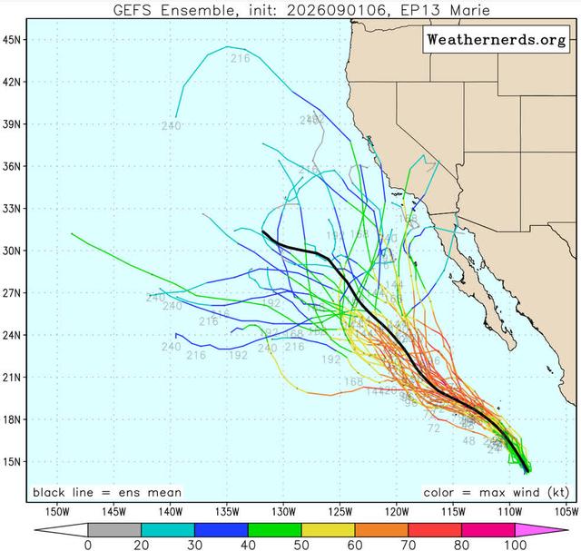
It's too early to tell for certain if Marie will impact Baja, but it's never too soon to speculate! WeatherNerds has posted a number of models predicting the path of the storm, which seems more likely to hit LA than TJ.


[Edited on 9-21-2026 by pauldavidmena]

SFandH - 9-1-2026 at 09:58 AM

The ocean temperature off the coast of San Diego at the Scripps Pier is 75 degrees. Hurricanes like 80-degree or higher water. SoCal may get a tropical storm, though.

pauldavidmena - 9-3-2026 at 04:35 AM

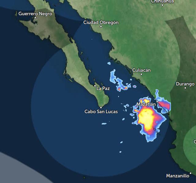
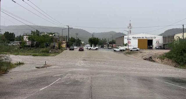
As was the case with Tropical Storm Karina, Hurricane Marie, while not directly impacting Baja, is drawing plenty of moisture, especially to southern Baja, in particular La Paz, as evidenced in this photo from El Independiente.


Don Jorge - 9-3-2026 at 01:55 PM

Given the current forecast models for this year it is possible that a tropical storm gets close to Pacific coast Baja California and or California.

Also quite posxible a strong Gulf of Alaska simultaneously rolls in from the north and combines to suck in copious amounts of the tropical moisture in a perfect storm moment. Weather nerd alert.

David K - 9-3-2026 at 03:57 PM

Gracias Don Jorge. That's the gleam in the eyes of the TV weather folks, too.
Everything comes in cycles, every few years.

Remember when a few Hwy. 1 bridges were washed out between Ensenada and El Rosario Valley? That was 2010.
See photo below, posted by BajaCactus on 1-23-2010 of Hwy. 1 crossing the Rosario Valley...

Every 5-10 years, we seem to get 1-2 years of wetter than 'typical' seasons. Notice that I didn't say "normal". none of us are alive long enough to see what normal weather is... if there is even such a thing! LOL


El Rosario bridge.jpg - 47kB

bill erhardt - 9-3-2026 at 07:33 PM

The SST on the Ridge outside Mag Bay last Saturday was 84+ degrees. About 10 degrees warmer than usual for this time of year. Often water that warm will draw storms roiling north along the coast onto Baja or even up into the Sea of Cortez, but so far all have veered west toward Hawaii south of Cabo. But, not to get complacent. There is still six weeks or so of storm season remaining.

mtgoat666 - 9-3-2026 at 09:39 PM

Quote: Originally posted by David K  
". none of us are alive long enough to see what normal weather is... if there is even such a thing!


I grew up in normal weather. Now is not normal. Science clearly shows us the climate has changed due to man’s green house gas pollution.
Give a hoot, dont pollute.
It aint easy being green.
Think global, act local.
Reduce, reuse, recycle.
Save the whales.

Ateo - 9-3-2026 at 11:17 PM

David, the remaining 3 members on this site really don't want to read your anti climate change FOX news talking points. Let's keep this about the big storm called Hurricane Marie that's currently off Baja....Or if you want we can just keep driving this site into irrelevance.

I'm headed down mañana to check the progress on my new place, get some tacos, surf, and sit by the pool.

Tioloco - 9-4-2026 at 05:51 AM

David, your observations are in line with mine. Hopefully we don't lose too many bridges on the highway this year. But in the case that we do, the locals always have a bypass setup rather quickly, fortunately. 60 years ago there were no bridges to wash out so we are fortunate for the highway we have now.

Like Ateo, I will burn some dinosaur fuel to go check on my place and have some tacos and cold cervezas on the beach. The security cameras just don't give me the same "feeling" as checking on it in person.

Ateo - 9-4-2026 at 07:26 AM

HaHa Tio. That was a good one.....

Actually today will be the first trip south of the border in an EV. Yes, I know the battery is full of toxic stuff and I do basically nothing to lower my carbon footprint other than have solar on my house (which was just a financial decision primarily).

Have a fun trip!

Waves should be nice.

Marie shut down Cabo Wabo in Cabo San Lucas

AKgringo - 9-4-2026 at 10:10 AM

Not my kind of tourist destination, but sorry to hear this anyway.
https://www.msn.com/en-us/travel/general/flooding-closes-sam...

JDCanuck - 9-4-2026 at 12:09 PM

Quote: Originally posted by Ateo  
HaHa Tio. That was a good one.....

Actually today will be the first trip south of the border in an EV. Yes, I know the battery is full of toxic stuff and I do basically nothing to lower my carbon footprint other than have solar on my house (which was just a financial decision primarily).

Have a fun trip!

Waves should be nice.


Ateo: I for one will be interested in hearing how the EV does down there. How far south are you heading and how many convenient places you find to recharge maybe? Perhaps not on this thread but a new one you start?

[Edited on 9-4-2026 by JDCanuck]

pauldavidmena - 9-5-2026 at 05:46 AM

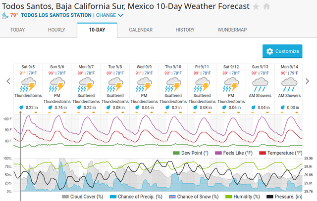
The week's forecast looks fairly nasty - lots of rain and nowhere to put it.


JDCanuck - 9-5-2026 at 05:58 AM

We could only wish we had that amount of rain to refill all our dams up here, let alone those very high humidity levels. Does anyone know if BCS has any plans to build any significant reservoirs to take advantage of these seasonal rains? All we have heard about is the increasingly critical declines in aquifer levels in the area.

[Edited on 9-5-2026 by JDCanuck]

pauldavidmena - 9-6-2026 at 10:29 AM

I've read that efforts to build reservoirs to capture rainfall have not been successful, but the details escape me. It looks like there's plenty of rain coming to the region today.


Would you live downstream from a dam in Baja?

AKgringo - 9-6-2026 at 10:52 AM

Given the numerous and repeated failures of bridges and road systems in the well-known flood planes in Baja, I would have grave doubts that they would get the engineering right to add a reservoir to the drainage!

There is quite a difference between a water storage system and a flood control system.

JDCanuck - 9-6-2026 at 11:31 AM

Seems a shame to let all that rainfall go to waste when they are spending so much on desalination plants and drawing down the aquifers so rapidly at the same time. Where we built we had a few things that made it uniquely challenging. Some of the very best solar capability in NA, steady winds and very high humidity with very heavy infrequent rainfalls that did a lot of damage to existing homes grouped around the seasonal watersheds or flood zones.
I did come across the El Novillo dam project for La Paz with a mid 2027 expected completion date to provide water and some flood reduction for the 250,000 homes in La Paz watershed
https://mexicobusiness.news/infrastructure/news/el-novillo-d...


[Edited on 9-6-2026 by JDCanuck]

pauldavidmena - 9-6-2026 at 03:16 PM

On the "Todos Santos Newsfeed" Facebook group, there are quite a few reports of dogs getting spooked by thunder and lightning and running away. It's fairly common for locals and expats alike to allow their dogs free reign during the day with the understanding that they'll be home at night, but the weather has thrown a monkey wrench into that idea.

Ateo - 9-6-2026 at 04:23 PM

Massive waves all weekend in Baja where I was.........even empty lineups that usually have 25 guys. I got rolled over the rocks at high tide coming in and I'm happy to be alive.

Time for some tacos.

David K - 9-6-2026 at 06:01 PM

So, here in North County San Diego, we got rain this morning! Not a lot, but the streets had water flowing. The rest of the day it was warm to hot, overcast, and high humidity. Like Hawaii, or Loreto in summer!
Now, have a nice evening.

9/8/26 update:
HOT HOT HOT... and muggy too. Was 106° today at 1:30, North County, along I-15.
Tall thunder clouds along the mountains with rain below, as far as I could see (into Baja, no doubt).

[Edited on 9-8-2026 by David K]

pauldavidmena - 9-8-2026 at 01:13 PM

A Facebook friend in Todos Santos mentioned getting four inches of rain in an hour on Saturday (September 6th).

AKgringo - 9-8-2026 at 01:52 PM

Quote: Originally posted by pauldavidmena  
A Facebook friend in Todos Santos mentioned getting four inches of rain in an hour on Saturday (September 6th).


The storm probably wiped out the road over the pass through the Los Naranjos Ranch again. I like that road, and would appreciate any recent info about it.

pauldavidmena - 9-9-2026 at 03:58 AM

I haven't read any specific reports about roads in BCS, but this article in the Gringo Gazette mentions 5 people being rescued from overflowing arroyos in Los Cabos.

pauldavidmena - 9-10-2026 at 07:30 AM

Marie is long gone, but some warm Gulf moisture will continue to influence BCS weather over the next few days.


Don Jorge - 9-18-2026 at 02:33 PM

An interesting tropical depression is forecast to form this weekend offshore of Mexico. What makes it interesting, at least from my perspective, is it appears to not be on an east to west parh as previously named storms behaved going out to sea away from Mexico and specifically Baja. Worth observing.

chippy - 9-19-2026 at 07:01 AM

Quote: Originally posted by Don Jorge  
An interesting tropical depression is forecast to form this weekend offshore of Mexico. What makes it interesting, at least from my perspective, is it appears to not be on an east to west parh as previously named storms behaved going out to sea away from Mexico and specifically Baja. Worth observing.


Yeah Windy models show it hitting the coast of Col/Jal on wens. as a tropical storm or more. Looks like I´ll be going down to Melaque to "batten down the hatches". Hopefully it doesn't wreak havoc like Patricia did.


[Edited on 9-19-2026 by chippy]

pauldavidmena - 9-19-2026 at 12:29 PM

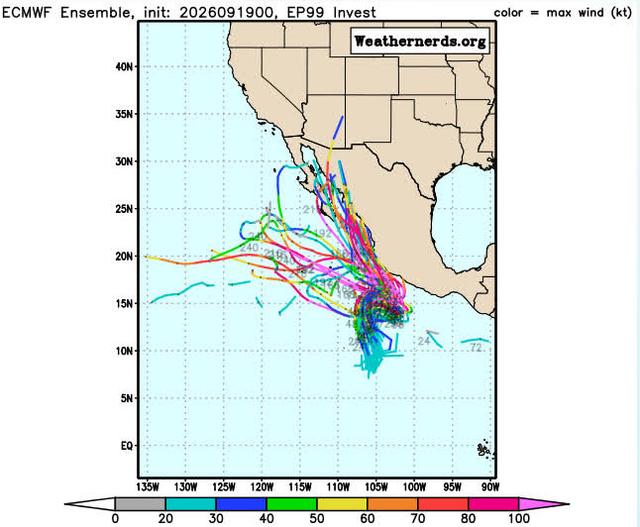
This "spaghetti model" from Weathernerds.com shows the potential for Invest EP99 to impact Baja. The hurricane season is far from over!


Edit: for some reason the image from postimg.cc doesn't seem to be uploading. I will continue to troubleshoot until I can get it working.

Edit #2: The image finally uploaded.

[Edited on 9-19-2026 by pauldavidmena]

[Edited on 9-19-2026 by pauldavidmena]

AKgringo - 9-19-2026 at 09:50 PM

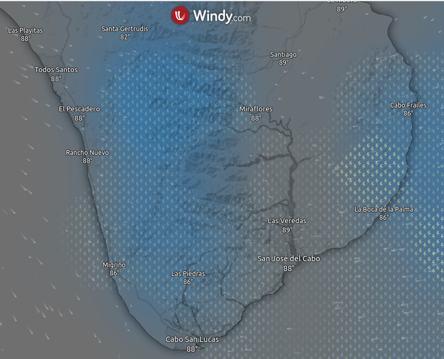
The current Windy model shows the storm traveling up the Pacific side of the cape and possibly coming ashore mi-way up the coast, about a week from now!

chippy - 9-20-2026 at 06:53 AM

It has again changed to going up the mainland coast and into the sea of Cortez while tropical storm Odalys takes a hard right and is heading towards Baja. Wonder what tomorrow will bring:?:

SFandH - 9-20-2026 at 07:29 AM

Quote: Originally posted by chippy  
It has again changed to going up the mainland coast and into the sea of Cortez while tropical storm Odalys takes a hard right and is heading towards Baja. Wonder what tomorrow will bring:?:


That agrees with the ECMWF weather model, the Windy.com default model, and the ICON model. They show the storm entering the Sea of Cortez this coming Friday. The GFS model shows the storm due south of Cabo at a safe distance on the same day.

Windy.com offers predictive, time-lapse animated graphics for all three models.

We'll see....

[Edited on 9-20-2026 by SFandH]

Fujiwhara Effect

Don Jorge - 9-20-2026 at 08:03 AM

Interesting indeed the guidance models have changed.
Would not be surprised to see a Fujiwhara Effect this season in the Eastern Pacific.

SFandH - 9-20-2026 at 08:39 AM

Quote: Originally posted by Don Jorge  
Interesting indeed the guidance models have changed.
Would not be surprised to see a Fujiwhara Effect this season in the Eastern Pacific.


Had to google that. I guess that would complicate predictions.

Officially a depression. Translated says

Don Jorge - 9-20-2026 at 03:34 PM

Watch closely, a major is forming and as of now do not know where or if it will make landfall. Thought we could all practice some Spanish why we wait and wait and wait...yup stole that from Casablanca. Jaja

Depresión Tropical Seventeen-E Discusión Especial Número 1
Centro Nacional de Huracanes del SNM Miami FL EP172026
300 PM CST domingo 20 de septiembre de 2026

La perturbación tropical al sur de México, anteriormente llamada
Invest 99E, está mejor organizada, con algunas bandas convectivas en
Watch closely. Gonna be a major next week and right now we dont know its exact route.

su semicírculo este. Aunque un paso reciente del dispersómetro no
hizo circulación, los movimientos de nubes bajas indican que el
sistema ahora tiene suficiente circulación de bajo nivel como para
calificar como depresión tropical, con una intensidad inicial de 30
kt esta advertencia.

Hasta ahora ha sido difícil de rastrear, por lo que el movimiento
inicial es de 030/7 kt. Según la mayoría de las previsiones de
trayectoria, es probable que el sistema gire hacia el este en las
próximas 12 a 24 horas. Aparentemente, este movimiento se debe a que
el sistema se encuentra incrustado en un giro ciclónico más amplio
cerca de la costa sur de México. Más adelante en el período de
pronóstico, se espera que el sistema gire hacia el noroeste y se
mueva hacia el sur de una máxima de nivel medio. El pronóstico
oficial se sitúa cerca del lado norte de la envolvente del modelo de
guía.

La depresión debería situarse dentro de un entorno propicio para su
fortalecimiento durante los próximos días, con una ligera
cizalladura del viento vertical y temperaturas muy altas en la
superficie del mar. El pronóstico de intensidad oficial está cerca
del consenso del modelo y muestra que el sistema se convertirá en un
huracán en 36 horas. Cabe señalar que las previsiones de Google
DeepMind y HCCA prevén un huracán más fuerte de lo que se muestra en
este pronóstico inicial.


Mensajes clave:
1. Las fuertes lluvias asociadas con la Depresión Tropical 17-E
afectarán las porciones costeras del suroeste de México esta
semana.Esta lluvia podría producir inundaciones y deslizamientos de
tierra que amenazan la vida, especialmente en áreas de terreno
empinado.

2. Se pronostica que la Depresión Tropical 17-E se fortalezca y se
acerque a la costa suroeste de México como huracán mayor a finales
de semana. Aunque es demasiado pronto para determinar la ubicación
exacta o la magnitud de los impactos asociados con el sistema,
México debería seguir de cerca su progreso y las actualizaciones del
pronóstico.

When it gets a name it earns it own thread.

SFandH - 9-20-2026 at 04:39 PM

Friday night.......maybe

hurricanes.png - 309kB

[Edited on 9-20-2026 by SFandH]

pauldavidmena - 9-21-2026 at 09:07 AM

What ever you do, don't shout "Marco!"


CaboMagic - 9-23-2026 at 07:09 AM

9/23/2026 6:30am

Our port will close today at noon.
Boats that left this morning can return at 'normal' time.

Satellite views (eebmike) show the outflow of Odalys - is being "pulled in" by the ridge from the north.

Edit: Odalys is the storm that was on its way west. This is not activity from Polo.

[Edited on 9-23-2026 by CaboMagic]

pauldavidmena - 9-23-2026 at 07:32 AM

Quote: Originally posted by CaboMagic  
9/23/2026 6:30am

Our port will close today at noon.
Boats that left this morning can return at 'normal' time.

Satellite views (eebmike) show the outflow of Odalys - is being "pulled in" by the ridge from the north.

Edit: Odalys is the storm that was on its way west. This is not activity from Polo.

[Edited on 9-23-2026 by CaboMagic]


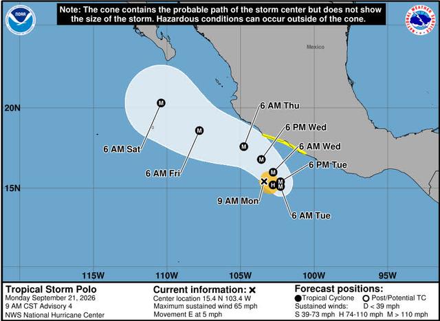
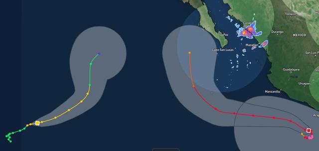
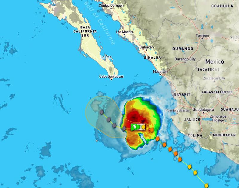
This image from Zoom Earth shows the projected interaction between Odalys and Polo.

CaboMagic - 9-23-2026 at 08:09 AM

Not sure what argument you are attempting to make PDM
If you look at CURRENT SATELLITE VIEWS you will see what I am referring to. The reason for TODAYS PORT CLOSURE is due to the OUTFLOW from ODALYS NOT POLO
See you in Cabo.


Quote: Originally posted by pauldavidmena  
Quote: Originally posted by CaboMagic  
9/23/2026 6:30am

Our port will close today at noon.
Boats that left this morning can return at 'normal' time.

Satellite views (eebmike) show the outflow of Odalys - is being "pulled in" by the ridge from the north.

Edit: Odalys is the storm that was on its way west. This is not activity from Polo.

[Edited on 9-23-2026 by CaboMagic]


This image from Zoom Earth shows the projected interaction between Odalys and Polo.

CaboMagic - 9-23-2026 at 08:12 AM

https://cdn.star.nesdis.noaa.gov/GOES19/ABI/SECTOR/eep/13/GO...

AKgringo - 9-23-2026 at 08:49 AM

Thank you Cabomagic for your on the scene feedback! Most of us are contributing from a thousand miles away.

CaboMagic - 9-23-2026 at 09:14 AM

PS as of now (Weds 9/23) the port will be closed tomorrow (Thurs)

BUT as we have experienced many times over the 30 years we know not to make predictions and wait for the esteemed Port Captain to announce.

PPS AK you are welcome.

pauldavidmena - 9-23-2026 at 09:19 AM

Quote: Originally posted by CaboMagic  
Not sure what argument you are attempting to make PDM
If you look at CURRENT SATELLITE VIEWS you will see what I am referring to. The reason for TODAYS PORT CLOSURE is due to the OUTFLOW from ODALYS NOT POLO
See you in Cabo.


No argument from me! I was just sharing a graphic of the potential interaction between the two storms later on. Like many of us, I'm watching carefully from afar, as I've just booked round-trip tickets to and from Cabo from Providence, RI for late January through mid-February.

Ateo - 9-23-2026 at 03:32 PM

I’m
Headed
South
Mañana!

CaboMagic - 9-23-2026 at 07:01 PM

Ateo pleasant and safe travels!

6pm Weds
Port Capt announced port will be OPEN tomorrow Thurs 6am - and potentially will be closed again like today to new traffic as of noon.

Those moving satellite videos on EEBMIKE are very helpful even for someone who is not climatologically edu-macated.

pauldavidmena - 10-7-2026 at 08:25 AM

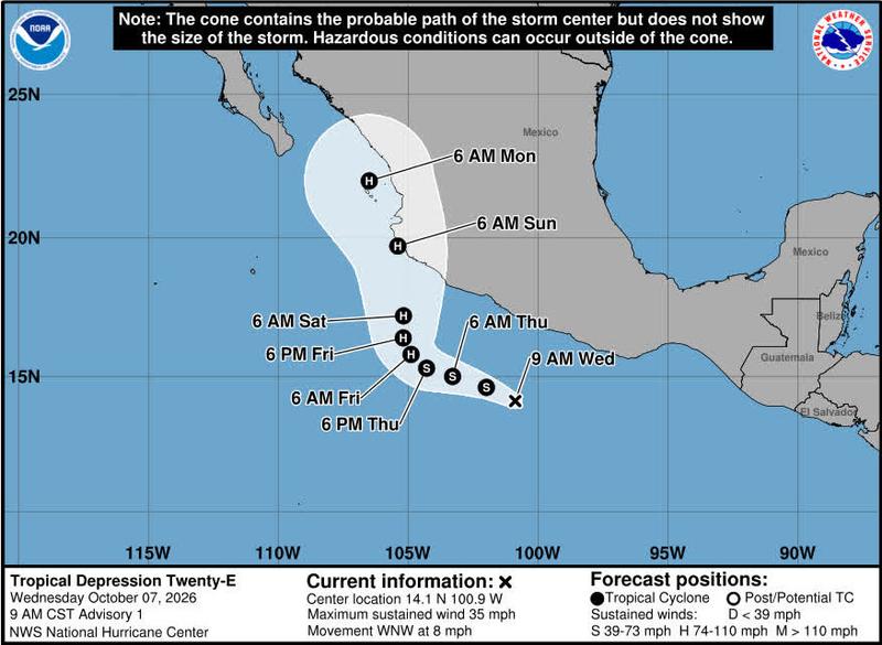
It looks like the next Tropical Storm and Hurricane might be Simon - currently known as Tropical Depression Twenty-E. Meanwhile, on the East Coast, the season's first hurricane, Isaias, is rapidly forming in the Gulf of Mexico.


lencho - 10-7-2026 at 09:24 AM

Quote: Originally posted by pauldavidmena  
for late January through mid-February.

Non-issue at those dates. Among the things I admire about Mexicans, is their quick and stoic recovery from natural disasters that would... keep U.S. lawyers in their Mercedes for years to come.

pauldavidmena - 10-7-2026 at 09:49 AM

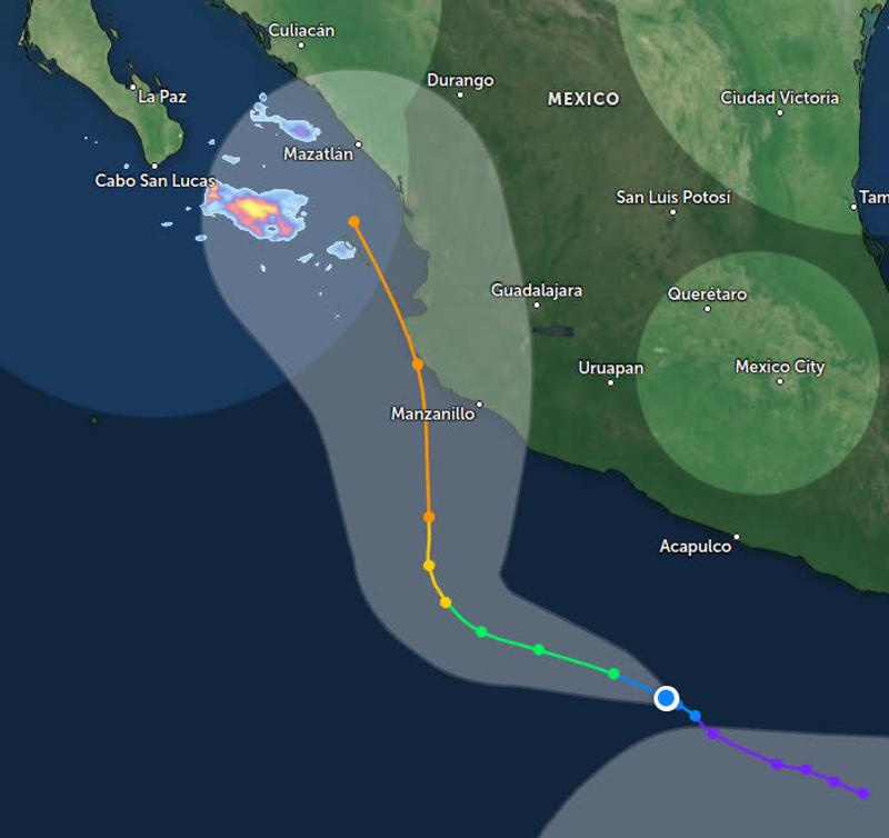
Here is forecast of Tropical Depression Twenty-E from Zoom Earth


pauldavidmena - 10-7-2026 at 09:51 AM

Quote: Originally posted by lencho  
Quote: Originally posted by pauldavidmena  
for late January through mid-February.

Non-issue at those dates. Among the things I admire about Mexicans, is their quick and stoic recovery from natural disasters that would... keep U.S. lawyers in their Mercedes for years to come.


I quite agree - and deeply respect - the resiliency of Mexicans to the various storms that frequent Baja.

Emergency repairs in the land of Mañana

AKgringo - 10-7-2026 at 04:04 PM

When a road has to get opened, things like permits, engineering, inspections, and environmental concerns probably won't get in the way.

Things that probably should get fixed sooner or later will still be getting blamed on hurricane Polo for more than a couple of years!

pauldavidmena - 10-10-2026 at 10:20 AM

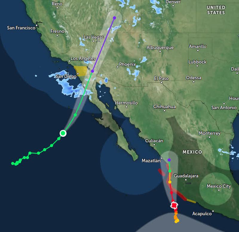
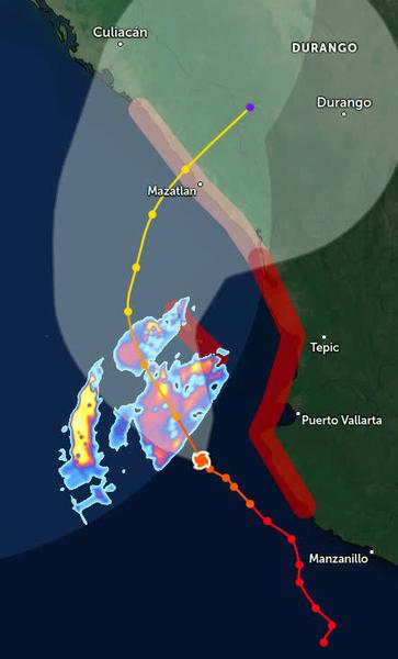
Zoom Radar forecasts Hurricane Simon to make landfall around Puerto Vallarta and travel north through Jalisco and Sinaloa before stalling out inland. Meanwhile, Tropical Storm Rachel continues to churn through the eastern Pacific, making landfall in northern Baja before crossing into Arizona and possibly Nevada and Utah. She's racking up that frequent flyer mileage!


David K - 10-10-2026 at 12:03 PM

In North County San Diego, at noon, it is all overcast and the wind is picking up. Rain not far away. Very humid and warm: 76°

pauldavidmena - 10-11-2026 at 11:35 AM

On Facebook, Ron Hoff (a.k.a. "BajaGringo") just reported significant damage in La Chorera despite the fact that the center of Post-Tropical Storm Rachel made landfall 60 miles to the north. At the moment, Hurricane Simon is wreaking havoc as it travels northward from Jalisco through Nayarit and Sinaloa. South of Alcapulco there is another blob of unsettled air that threatens to form yet another storm. Be careful out there!

pauldavidmena - 10-12-2026 at 05:08 AM

It looks like Simon has veered slightly to the northwest, sparing Puerto Vallarta a direct hit while losing some strength before making landfall in Mazatlan. Given the size of the storm, its outer bands are likely to bring more rain to southern Baja. Best to continue to monitor the situation and remain prepared.


lencho - 10-12-2026 at 07:00 AM

Quote: Originally posted by pauldavidmena  
...another blob of unsettled air

That's meteorologist technical jargon, right? :biggrin:

pauldavidmena - 10-12-2026 at 11:51 AM

Quote: Originally posted by lencho  
Quote: Originally posted by pauldavidmena  
...another blob of unsettled air

That's meteorologist technical jargon, right? :biggrin:


Sorry - I didn't mean to get overly technical! :biggrin:

Coincidentally, in my former line of work (IT), a BLOB was a "Binary Large OBject," basically any big unstructured non-text file.

lencho - 10-12-2026 at 03:02 PM

Quote: Originally posted by pauldavidmena  
...BLOB was a "Binary Large OBject," basically any big unstructured non-text file.

Well, that mass of air is binary.

Or it isn't.

pauldavidmena - 10-13-2026 at 07:28 AM

Quote: Originally posted by lencho  
Quote: Originally posted by pauldavidmena  
...BLOB was a "Binary Large OBject," basically any big unstructured non-text file.

Well, that mass of air is binary.

Or it isn't.


Simon is still full of ones and zeros!

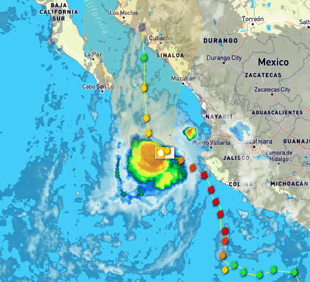
WeatherUnderground shows it moving northwest before turning due north, no longer headed for Mazatlán but instead closer to Culiacán. Unfortunately, with the storm moving very slowly, the Pacific coast of Mexico is getting a lot of rain. Furthermore, it looks like the outer bands of the storm will impact Baja as well.


AKgringo - 10-13-2026 at 07:53 AM

I was playing with the Windy forecast site, and there is a significant difference between the several models available. All of them show Baja Sur getting some more rain, but Simon coming ashore could be anywhere from Mazatlán to Guaymas.

How long it hovers over the ocean south of Baja could have quite an impact on the amount of wind and rain generated.

As I stated before, it must be a frustrating year for the forecasters!

pauldavidmena - 10-14-2026 at 05:18 AM

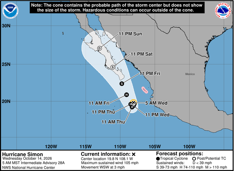
Indeed, the last forecast I saw from the National Hurricane Center shows Simon making landfall around Cabo as a Tropical Storm. And speaking of tropical storms, Trudy has just been named, and is on a similar trajectory!


It looks like Ensenada got slammed hard!

AKgringo - 10-14-2026 at 08:53 AM

This is an eight and a half minute video of some of the damage Rachel left behind; https://www.msn.com/en-us/news/other/tropical-storm-rachel-w...

[Edited on 10-14-2026 by AKgringo]

pauldavidmena - 10-14-2026 at 12:58 PM

Quote: Originally posted by AKgringo  
This is an eight and a half minute video of some of the damage Rachel left behind; https://www.msn.com/en-us/news/other/tropical-storm-rachel-w...

[Edited on 10-14-2026 by AKgringo]


I saw some similar footage on Facebook. As we can see, Simon is taking his time to decide where to stir things up, and Trudy is saying "Hold my margarita!"

AKgringo - 10-14-2026 at 01:36 PM

It looks like Simon might have "Dreams of Pescadero"!

pauldavidmena - 10-18-2026 at 12:02 PM

Quote: Originally posted by AKgringo  
It looks like Simon might have "Dreams of Pescadero"!


Now there's a great name for an infrequently updated blog!

AKgringo - 10-18-2026 at 05:43 PM

Well Simon apparently took a nap, but maybe Trudy will come by for a visit.

pauldavidmena - 10-19-2026 at 04:26 AM

Quote: Originally posted by AKgringo  
Well Simon apparently took a nap, but maybe Trudy will come by for a visit.


It looks like Trudy, after lingering too long on the Pacific coast, is running out of steam and will be downgraded to a Tropical Depression later today before becoming a remnant of her former self.