BajaNomad

GPS for Xmas; which one?

Hook - 11-13-2006 at 02:50 PM

I'd like to get a GPS unit that I can use on foot as well as in the vehicle.

Kinda leaning towards either the Garmin 60csx or the 76csx. Any and all opinions welcomed.

Or, if you think another is a better deal, let me know.

bajalou - 11-13-2006 at 02:52 PM

I have the 76CSx for several months and love it - I wouldn't consider anything else.

leadmoto - 11-13-2006 at 03:25 PM

I agree with Baja Lou. I have a 60CS that's taken some serious beatings and still works great.

Bruce R Leech - 11-13-2006 at 03:27 PM

Garmin 76CSx is the choice anything else is a compromise.

Having some trouble figuring out

Hook - 11-13-2006 at 03:34 PM

what the difference is between the 60csx and the 76csx. All I can see is that the 76 comes with a 128 meg microSD card and it floats. What else?

leadmoto - 11-13-2006 at 03:41 PM

I believe Cycoactive.com has a compairison chart.

Hook - 11-13-2006 at 03:53 PM

Lou, what is the diagonal measurement on the LCD screen on the 76. I am also considering a somewhat larger one that could double in the car and on the boat as well as being a rather clunky one for on foot (which I do the least). It's the 276c, but they are only describing its screen size in terms of diagonal measurement instead of H x W.

A little concerned about the size of the 60/76 screen for vehicle use. I have old eyes that are not getting better.

tripledigitken - 11-13-2006 at 04:01 PM

Hook,

I have had a III+ and the V Garmin. Which I believe are similar in size to the 60/76. I used them primarly on my motorcyles. I switched to the 276c about 2 years ago for the same concerns you have the smaller screen was difficult to see. The larger screen of the 276C is a huge improvement, and is a tremendous unit. I have not used it yet as a marine unit, but I hope to in the future. You can change the screen from landscape to portrait if you want to hand carry the unit. I have used it extensively for Rallying and have loaded it with the baja topo's also. I couldn't be more pleased with it, unless there was a Parker 21 attached to it.

Taco de Baja - 11-13-2006 at 04:24 PM

Quote:
Originally posted by Hook
Lou, what is the diagonal measurement on the LCD screen on the 76. I


I really like my 76csx. the screen is plenty big for my middle age eyes ;D and easy to see even in bright sun light

It measures 1.4" by 2.15" or 2.6" diag.

And the actual features on the 76csx are really nice too :yes:

Hook - 11-13-2006 at 04:32 PM

Quote:
Originally posted by tripledigitken
Hook,

I have had a III+ and the V Garmin. Which I believe are similar in size to the 60/76. I used them primarly on my motorcyles. I switched to the 276c about 2 years ago for the same concerns you have the smaller screen was difficult to see. The larger screen of the 276C is a huge improvement, and is a tremendous unit. I have not used it yet as a marine unit, but I hope to in the future. You can change the screen from landscape to portrait if you want to hand carry the unit. I have used it extensively for Rallying and have loaded it with the baja topo's also. I couldn't be more pleased with it, unless there was a Parker 21 attached to it.


Yeah, I'm thinking about upgrading the boat GPS and am trying to find the best compromise for all three uses. My older Furuno 1650F is just too slow retracing the charts especially if I am drifting over a spot all the way zoomed in and then retracing my steps. but then it is 5+ year old technology.

Did you get a portable carrying case for the 276c for on-foot use? Looks like it will fit in a fanny pack easily, though.

bajalou - 11-13-2006 at 04:33 PM

A friend has the III and also a V and I much prefer the 76 to either of those. In a vehicle I turn the backlight on all the time and have no trouble seeing it even with my older eyes. Other than floating, the main differences I see in the 60 and 76 are button placement. The 76CSx takes a MicroSD card to store maps and track data - I believe the 276 takes a proprietary Garmin memory card. I have a 512m card in it now and have the topo and MapSource maps of half of Calif, all of AZ,NM, and southern half of Colo and Utah, plus LB maps of
Baja and it still has room for several thousand miles of stored tracks. Great features - electronic compass. Don't think you can miss with one of these.

Have a couple of Garmin's....

Mexray - 11-13-2006 at 04:43 PM

...and I think I'll go for the 76csx for my next 'handheld' type, unless they release something better along those lines.

For our recent road-trip in the US last month, I picked up a Garmin C-330 StreetPilot for use in our pickup/camper. I used an external antenna with it, as the camper cab over section blocked most satellite's view of the unit's internal antenna when mounted inside the cab's windshield.

The C-330 worked great, and really helped us navigate around the 15 or so states we traveled. I now wish I'd spent a few more bucks for the better StreetPilot model that calls out the actual street name for turns, instead of just "In 0.2 miles, turn right". It was sometimes a bit confusing when there were two turning choices, close together, and you are trying to watch traffic and select the correct place to turn...having the unit tell you to "Turn right on A street" would have been preferred - but that option is another $150 bucks, as I recall, but now a worth while investment.

The accuracy of the C-330 was quite good. The data base of address' and useful business locations needs some updating, but that's an ongoing task! The data base allows you to find nearby places easily, by category, IE; Fuel, Food, etc - and it gives you the names, how far away, and exact directions, etc. The unit automatically recalculates a route if you make a wrong turn, or if the highway has been re-routed.

Over-all, a good tool for navigating around the USA - but sorry, they don't yet have any data for South of the border!

Hook - 11-13-2006 at 04:49 PM

Yes, Mexray, I figured I'd need an ext. ant. with a cabover as well. The non-marine ones are pretty reasonably priced, unless you go with the "Smart GPS" antenna.

Wont the LB charts work on that Streetpilot of yours? I am not familiar with all the land map permutations yet. :?:

tripledigitken - 11-13-2006 at 04:51 PM

Hook,

No I didn't get a case for it. It will fit in a fanny pack or a large jacket pocket though. I saved the V for that purpose by the way. Baja Lou is correct the 276C requires Garmin's memory card. With the 128 card I have baja loaded and about everything west of the Rockies, except WA, OR , MT. I do want to get a larger card (256 or 512). If you buy it try to get at least a 256/512 card, usually you can cut a package deal and save a few bucks.


Ken

Summanus - 11-13-2006 at 05:05 PM

I have the Garmin GPS 12...a basic, no frills, pretty damn good handheld for about 100 bucks. 2.5" diagonal screen. It has about all you need, I expect, to navigate the roads, trails, and mountains of Baja ....or the Cortez.

It is telling me right now that we are 1613 miles from our last location...our hotel room in Gulfo Dulce, Costa Rica. Now why do I need to know that?

[Edited on 11-14-2006 by Summanus]

bajalou - 11-13-2006 at 05:18 PM

I used a 12 then a 12XL for years - but would never go back. The ability to have a real map show up on the screen, while not always necessary, sure is nice. And color makes it many times more readable.

Summanus - 11-13-2006 at 05:37 PM

If I ever lose this one, bajalou, I will look forward to upgrading.;D and will be taking notes on this thread.

Until then, my little 12 has seen use all on many a back country hunting trip...the trail back to camp on my 12 is always easy to follow. We hope it will also be easy to return to a boat ramp in the fog, which sometimes happens, we have been warned.

Taco de Baja - 11-13-2006 at 05:38 PM

Quote:
Originally posted by Hook
Yes, Mexray, I figured I'd need an ext. ant. with a cabover as well. The non-marine ones are pretty reasonably priced, unless you go with the "Smart GPS" antenna.


If you go with the 76csx you may not have to get the external antenna. Try before you buy one. The SiRF antenna inside the 76csx is mighty powerful.

My unit will get reception on the ground floor of a 2-story concrete tilt-up building :o

[Edited on 11-14-2006 by Taco de Baja]

Bruce R Leech - 11-13-2006 at 05:46 PM

Quote:
Originally posted by Taco de Baja
Quote:
Originally posted by Hook
Yes, Mexray, I figured I'd need an ext. ant. with a cabover as well. The non-marine ones are pretty reasonably priced, unless you go with the "Smart GPS" antenna.


If you go with the 76csx you may not have to get the external antenna. Try before you buy one. The SiRF antenna inside the 76csx is mighty powerful.

My unit will get reception on the ground floor of a 2-story concrete tilt-up building :o

[Edited on 11-14-2006 by Taco de Baja]


what is a concrete tilt-up building? I want to check mine and see if it will work in one of those.

bajalou - 11-13-2006 at 06:09 PM

I too would try the 76CSx before getting a external antenna. I live in a aluminum 5th wheel trailer under a plywood roofed ramada and it locates and holds a signal inside. Set it on the seat between the driver and passenger and it does grate. It amazed me when I got it.

Taco de Baja - 11-14-2006 at 08:44 AM

Quote:
Originally posted by Bruce R Leech

what is a concrete tilt-up building? I want to check mine and see if it will work in one of those.


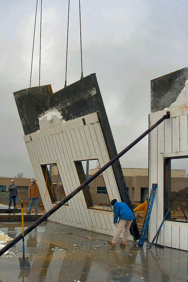
It’s an industrial/office complex building they build in many areas these days. Supposed to be cheaper and faster than building a concrete block building
They form and pour the walls, about 4-6" thick, on the ground, including openings for doors and windows. Then they hoist the walls up (tilt them up) with a crane and bolt then to the slab on the ground and to each other. Then they install the 2nd story floor and roof. See photo montage below.

I am getting reception through the 4”concrete and the several feet of roof and 1st floor ceiling/ 2nd floor floor.

Oh yea, when I visited my brother in Idaho this summer the 76csx worked great on the plane


Pouring


Tilting


Rough building


Finished

Hook - 11-14-2006 at 09:24 AM

I am wondering if this SiRF antenna technology is expected to make its way into the larger Garmin units. It would seem to eliminate the need for external antenna almost completely on boats, planes, cars.

Bruce R Leech - 11-14-2006 at 09:28 AM

Quote:
Originally posted by Hook
I am wondering if this SiRF antenna technology is expected to make its way into the larger Garmin units. It would seem to eliminate the need for external antenna almost completely on boats, planes, cars.


it will eventually

Bruce R Leech - 11-14-2006 at 09:29 AM

Quote:
Originally posted by Taco de Baja
Quote:
Originally posted by Bruce R Leech

what is a concrete tilt-up building? I want to check mine and see if it will work in one of those.


It’s an industrial/office complex building they build in many areas these days. Supposed to be cheaper and faster than building a concrete block building
They form and pour the walls, about 4-6" thick, on the ground, including openings for doors and windows. Then they hoist the walls up (tilt them up) with a crane and bolt then to the slab on the ground and to each other. Then they install the 2nd story floor and roof. See photo montage below.

I am getting reception through the 4”concrete and the several feet of roof and 1st floor ceiling/ 2nd floor floor.

Oh yea, when I visited my brother in Idaho this summer the 76csx worked great on the plane


Pouring


Tilting


Rough building


Finished


Taco de Baja that is cool . I wonder if anyone is doing that in Mexico

Taco de Baja - 11-14-2006 at 10:18 AM

I believe many of the industrial buildings in Mexicali are of this style....I did not pay too much attention, since they are so common in Southern California these days.

The new Wal-Mart and Costco in Ensenada may be too, as warehouse type buildings are especially suited to tilt-ups.

bajalou - 11-14-2006 at 08:42 PM

I think I saw them putting up some tilt-ups along the river road? between the downtown border crossing and Lazero Card##as in Mexicali. Government buildings I believe.

Hook - 11-15-2006 at 01:58 PM

I'm all but convinced that the 76csx is the one I want. If the 276c wasnt such old technology as GPS receivers go, I would opt for it.

A friend who recently purchased a 60csx is bringing it over so I can see if I can live with the screen size.

Anybody found a good source for a 1 gig microSD chip by either Sandisk or Kingston?

bajalou - 11-15-2006 at 03:01 PM

Sometimes the cell phone stores have good deals on the chip since it was developed and first used in cell phones. - Called a "TransFlash" card - same exact thing.

Hook - 11-15-2006 at 05:56 PM

Lou, I see that Fry's online has a 1 gig Kingston for 29.99 this week. Is that a good price?

bajalou - 11-15-2006 at 06:50 PM

Sounds pretty good to me, Hook I'd go for it. Think I paid a bit more for mine.

Attn 76 users.

Hook - 11-16-2006 at 11:11 AM

One issue has now got me considering the 60csx, which has virtually the same capabilities as the 76, except it does not float (although it has the same water-resistent rating as the 76) and it only comes with a 64 mg chip (which I am upgrading anyway).

I think I like the ergonomics of operation of the 60 better as it has the buttons BELOW the screen instead of above it. It would seem that in a car, depressing buttons would actually have you covering up the screen on the 76 unless you do an awkward from-the-side thing and use your thumb to depress.

Any thoughts on this?

bajalou - 11-16-2006 at 11:16 AM

Having had a 40, a 38, a 12 and a 12XL, I've been used to having the buttons etc above the screen - so for me the 60 is awkward to use.

:biggrin:

Hook - 11-17-2006 at 12:53 PM

Ended up going with the 60csx. Although it lists for more than the 76csx for some reason, the 50.00 rebate and the placement of the buttons turned me.

I think the screen will be large enough for driving and, boy, are these bright.

bajaguy - 11-17-2006 at 12:59 PM

Can you get the pre loaded chips for the 60???

Taco de Baja - 11-17-2006 at 01:10 PM

Quote:
Originally posted by bajaguy
Can you get the pre loaded chips for the 60???


Yes, off the Garmon website

bajaguy - 11-17-2006 at 01:28 PM

Looks like $415 plus the $50 rebate on Amazon.com

Hook - 11-17-2006 at 06:43 PM

Try GPSonsale.com out of Arizona. I think it was 364.00 not including the 50.00 rebate. No sales tax if out of state.

But you can get better deals on the accessories on Amazon.com.

bajalou - 11-17-2006 at 07:25 PM

Quote:
Originally posted by bajaguy
Can you get the pre loaded chips for the 60???


If you're going to Baja, be sure and get LBMaps maps of Baja. He has Topos and road/city map that are right on.

http://www.lbmaps.com/

:biggrin:

Monia - 11-18-2006 at 12:17 PM

Ok, so I was happily following this thread because I am getting my honey a GPS for Xmas, but now I am confused! Per your recommendations, I thought about getting him the Garmin 60csx, but should I get it on Amazon or GPSonsale.com and what accesories do you need and what are pre loaded chips????
I guess I should ask you guys, if you were to get one as a gift which would you prefer? He's never had one, although, God knows he needs one.
I'm just a stupid woman when it comes to these gadgety things, so any help would be very appreciated!!! ;D

Taco de Baja - 11-18-2006 at 01:59 PM

Quote:
Originally posted by Monia
what accessories do you need and what are pre loaded chips????


Get the MapSource Topo CD. This allows you to download Topo and forest service roads into the GPS.

Get the Baja Topo from LBMaps, you need the MapSource program to run LBMaps maps though.

If you do a lot of city driving get the MapSource City Maps, this has most street names and many more streets that the base map in the unit or the Topo Map version.

Pre loaded chips are micro SD cards that contain the Topo maps already, these are really only useful if you do not have a computer.

You cant lose with either the 60csx or the 76csx, they are both great units.

As far as where to buy, go with whichever retailer is cheaper. Remember to include any shipping or state taxes. Some other places to look are GPSCity.com and GPSNow.com.....Boy, all these GPS places sure have original names :rolleyes:
Or use an Internet low price search site like BizRate.com or NexTag.com and enter the unit you want. They will give you a choice of retailers with their prices. and links to the retailer's site

[Edited on 11-18-2006 by Taco de Baja]

Hook - 11-18-2006 at 08:00 PM

The 60 and the 76 are virtually identical units except for:

-the 76 floats
-the 76 has buttons above the screen, the 60 below
-the 76 comes with a 128 meg chip, NOT pre-loaded
-the 60 come with a 64 meg chip, NOT pre-loaded
-the 60 comes with a belt clip

At this time, the overall cost of the 60 is less due to the rebate.

Hook - 11-21-2006 at 01:28 PM

I got my 60 csx last night and need to ask someone about the US Topo CD from Mapsource.

I loaded in a bunch of quadrants from the CD successfully. Basically took care of all of SoCal south of Joshua Tree out to the AZ border. It was MAYBE 10 megs at the most. Prior to this, I maximized the detail in the mapsource program and also maximized the detail in the map setup of the GPS.

I am pretty disappointed with the lack of detail in the GPS display. It seems like the contour interval is about 200 feet or greater. Is that normal? Did I load in the software wrong or is it an improper GPS setting?

mtgoat666 - 11-21-2006 at 02:48 PM

Quote:
Originally posted by Hook
I am pretty disappointed with the lack of detail in the GPS display. It seems like the contour interval is about 200 feet or greater. Is that normal? Did I load in the software wrong or is it an improper GPS setting?


The Garmin topo maps are not very detailed (e.g. topo contours of about 200 feet). I recommend you get topo maps from other sources. The high-quality maps with detailed contours are usually available at one state per DVD.

Taco de Baja - 11-21-2006 at 03:58 PM

Quote:
Originally posted by Hook
I got my 60 csx last night and need to ask someone about the US Topo CD from Mapsource.

I loaded in a bunch of quadrants from the CD successfully. Basically took care of all of SoCal south of Joshua Tree out to the AZ border. It was MAYBE 10 megs at the most. Prior to this, I maximized the detail in the mapsource program and also maximized the detail in the map setup of the GPS.

I am pretty disappointed with the lack of detail in the GPS display. It seems like the contour interval is about 200 feet or greater. Is that normal? Did I load in the software wrong or is it an improper GPS setting?


You did not do anything wrong.

The contour interval is set at 50 meters because that was the source 1:100,000 scale map had on it.

But this is really plenty detailed, anymore and you would have a brown screen filled with topo lines when zoomed out in mountainous terrain.....try scrolling around your map to a known mountainous area and zoom in and out, you'll see what I mean. 50m is a nice scale for a hand held unit as it allows you to see canyons, peaks, ridges, dirt roads, streams, etc. without overdoing it.

The only way to get better detail, that can be downloaded into the unit, is through a limited set of maps that cover some National Parks.

Or you could go with a State map set like those provided by All Topo Maps, hook up you GPS to a laptop, and enable real time tracking on the laptop screen....But then you have to lug around a laptop.....

Hook - 11-21-2006 at 04:32 PM

Thanks Taco de Topo.;D I really doubted I did anything wrong.

Let me look around again. I was definitely in a rather flat area (Mesquite Oasis area in Anza Borrego off Vallecito Wash). There are arroyos to walk around inside near this area and they dont really show at all, although the sides are not anything I would want to go up and over on.

Maybe this is good for more mountainous terrain like the Sierras but I am pretty disappointed, really. You could easily walk towards a location, thing it was relatively flat and there could be a 150 foot hill to go over or around.

What's the scale on the LBMaps?

Taco de Baja - 11-22-2006 at 08:46 AM

Scale on LB maps is the same 1 contour every 50m.

Again, this is nice if in a mountainous terrain. Very Good detail (almost too much ;D) IN Canyon Guadalupe, for example, bad if you are out in the middle of the Laguna Salada, east of Guadalupe....but the roads do show up on the map, at least where the roads were when the map was made......

I like the name, "Taco de Topo" :lol:

Hook - 11-22-2006 at 09:08 AM

Looked around in some other areas. I am not displeased with the software now. It will be adequate.

I guess I was thinking that it would have the detail of the 40 and 80 foot contour interval topos I carried around with me in the Sierra Nevadas for so long. That's really not practical.

Created my first route last night for the T-Day trip. Used a combo of the internal hwy map (disappointingly low road detail), the Trip and Waypoint Manager and the topo map, which had much better road coverage. I did one leg using the "route tool" in T&W M. It created these vector lines between my road waypoints that really dont follow the road; they are vectors as the crow flies. Do you know if these will be converted to hwy directions/mileage when I hit the "navigate" button on the route?

BTW, the database for the topo must be quite old, in terms of the paved roads. There are sections of roads in my hometown that have been in for 20 years that are missing on the topo.

Neal Johns - 11-22-2006 at 10:04 AM

Hook, I too, have a 60CSx (my seventh Garmin). Works great in my metal roof cabover without an external antenna. The bigger screen 176/276 uses an older chip set and will not do this, or work well under all those giant trees in AB. :lol:

The bad news is, other than the State Park series, the only topos better than what you have, will work only on laptops.

Garmin Roads and Recreation has about the same roads as the Garmin Topo but is no longer available. But, if you happen to be driving by the bottom of Cajon Pass..........drop by Lytle Creek. :yes:

There are lots of free programs out there for managing tracks and waypoints. Here is a "do all" one: http://www.gpstm.com/

The Baja Topo from LBMaps is great. Buy it.

tripledigitken - 11-22-2006 at 10:56 AM

I have the Garmin 276 and it works fine in our pickup with a 10' Lance camper without an external antenna 99% of the time. It does have reception problems in heavy trees and deep canyons.

Enjoy you new Garmin GPS, they are great devices. It's loaded with the LB Maps everytime I venture south.

:yes:

Hook - 11-22-2006 at 11:38 AM

Yeah, Neil, it was the new SiRF receiver that made me choose it over the older generation units with larger screens. I acquired 10 satellites coming home last night with no ext ant in the truck and the cabover in place.

Still finalizing my accessory list. I actually split the cost of the US Topo with another guy and he burnt me a copy. Works fine. I assume that is not an option with the Mapsource city Navigator CD that uses some kind of unlock? I guess I will go with the highway kit that includes a couple auto mounts, the CD, the lighter plug. Probably Amazon.com for this with the free, slow shipping.

joel - 6-25-2007 at 07:16 PM

Does anyone have any thoughts on just getting a USB GPS unit for my laptop and running the maps on it? I'm only looking for a unit to help me when I'm lost, so it seems like it would be a lot cheaper and give me a huge screen when I need it?

It's interesting to me that no one mentions this obvious option.

Hook - 6-25-2007 at 10:31 PM

Quote:
Originally posted by joel
Does anyone have any thoughts on just getting a USB GPS unit for my laptop and running the maps on it? I'm only looking for a unit to help me when I'm lost, so it seems like it would be a lot cheaper and give me a huge screen when I need it?

It's interesting to me that no one mentions this obvious option.


Thats probably because many of us dont have the space to operate a laptop up front while we're driving. These smaller units are more durable than laptops (especially off road), can be placed within your field of view while driving and can be taken with you when hiking.

I still may experiment with interfacing my Garmin with a laptop, assuming you can use it simply as a GPS receiver and install some other software on the laptop. Could be workable on a flybridge of a boat.

[Edited on 6-26-2007 by Hook]

joel - 6-26-2007 at 10:02 AM

To answer my own question, there appears to be a great solution for a laptop user like myself. For $100 you get the GPS antenna and the base software you need to run the LB maps (which cost an additional $50).

I found it on Amazon and has a lot of good reviews:

Amazon link

Hook - 6-26-2007 at 10:10 AM

Quote:
Originally posted by joel
To answer my own question, there appears to be a great solution for a laptop user like myself. For $100 you get the GPS antenna and the base software you need to run the LB maps (which cost an additional $50).

I found it on Amazon and has a lot of good reviews:

Amazon link


I'd say that's the unit to go with but how are you gonna place the laptop while driving?

Iflyfish - 6-26-2007 at 11:17 PM

We got a Garmin 340 while in SoCal. We found it indispensable, named it Christopher, after the patron saint of travelers. It is the low end model that will give you verbal directions. Very easy to use.

We liked it so much we purchased them for our adult children as Christmas presents. They love them too.

We purchased from an oline dealer of referbished models. I had a minor problem with the initial unit and they responded immediatly to resolve the problem.

Alas, not much available for Mexico. I keep looking. If anyone hears of Garmin compatable soft ware covering Mexico, let me and everyone els on the list with a gps know.

Iflyfish

joel - 6-27-2007 at 07:59 AM

I only want it for if/when we get lost, so the laptop should be fine. My wife can put it on her lap as she's the navigator anyways -- she often just can't figure out where we are on the map.

Lou

BajaRob - 6-27-2007 at 06:24 PM

You convinced me. I ordered the 76csx from Amazon and it will arrive on Friday. Which Baja map program do you recommend? Thanks in advance.

bajalou - 6-27-2007 at 06:26 PM

The ones from LBMaps show great detail - trails topo info etc. Great product.

BajaRob - 6-28-2007 at 10:21 AM

Thanks Lou, I ordered LB's Navigator via email.