BajaNomad

Kevin's Quad Ride to Historic San Isidoro 2002 (includes photos)

David K - 2-3-2007 at 11:23 PM

San Isidoro was a resting place for Junipero Serra on his long walk from Loreto to San Diego and on to San Francisco... and later became a mission visita for the Dominicans.

In cleaning out my email files, I came across a great trip report from Baja Nomad Kevin in Oklahoma, who unfortunately doesn't get online often. Kevin is one of the contributors to my Baja Missions web page (along with Jack Swords, academicanachist and Ed Vernon)...

Following this report are 5 photos of San Isidoro, which was a visita between the missions of Santo Domingo and San Pedro Martir. See Jack Swords photos of Mision San Pedro Martir at http://vivabaja.com/bajamissions from his trip in 2003...
=========================================================

Subject: San Pedro Martir #1
Sent: Saturday, May 1, 2004 10:10 AM
Hi David,

I am so excited about Jack getting up to San Pedro Martir and for so much of that lost Mision that remains. Since last we talked (EMAILED) we did make an attempt up the hill to San Pedro Martir from San Quintin but did not make it. It was a one day excursion to go just as far as we could and get the lay of the land of Rancho Nueva York to as close to Rancho Isidoro as we could. We started at 4 AM on January 8, 2004 with two 4-wheelers and one dirt bike which would act as a scout. It is quite a thrill riding in the dark and having the Sun rise in all those hills and switchbacks.

We had crossed considerable amount of water when we got to a familiar gate which we had passed from previous trips but were astounded to find that our little burro trail from before was now part of the BAJA 500 or 1000 trek. It was like finding an on ramp to HiWay 5 in Southern Cal. All the ducking and bushwacking from before was no longer required since someone had run a dozier through there. We re-checked our GPS and TOPO"S and pushed on. The new BAJA 500/1000 trail was following the exact trail to San Pedro Martir, thoughts of pulling in San Pedro Martir Mision before lunch actually crossed our minds. Boy was that wrong!!!!!!

My Brother-In-Law Mike on his dirt bike was making great time but we unfortunately missed a key "turn-off" from the BAJA Trek to the original burro trail to Rancho San Isidoro. We ended up following the BAJA 500/1000 Trek to somewhere near Rio Santa Eulali, we gathered here in this wonderful place of large trees and great rock out-croppings. We decided that we will return to this area to explore more in the future, as you can say so many canyons, so little time.

We backtracked to the original burro trail into Rancho San Isidoro (Turn off is 30 43.52N, 115 32.04W at 3674 feet. The next 2.87 miles of trail/creek bed was the hardest trail I have ever been on in my life. The trail decended 738 feet and I not only rolled my 4-wheeler once, I rolled it twice. This was quite an deal since in my 20 years of riding I had never previously rolled my 4-wheeler. These were very slow roll overs so no injuries occurred except to my pride!!!!. With GPS in hand we had gone 2.5 miles and finally leveled out, but we could see nothing. The mountain scrubbrush and cactus was about 6 to 6 1/2 feet tall obscuring our views. We set the bearing on the GPS and rolled on.

We soon came to a beautiful ice cold creek which was flowing nicely. We crossed the creek and we were there, Rancho San Isidoro. What a great place. (30 45.94N, 115 32.76W, 2936 feet) Old adobe buildings remained, rock walls, corralls and a cemetary. (I have attached 5 pic's, which are re-photos of 35MM photos with my digital camara, not the best quality but my scanner has refused to work.). We were then faced with a dilema in that it took a little longer to get to San Isidoro with missing our "turn-off" and the "Trail of tears" that time was winning its' battle with us. We decided to do a few exploratory runs north and west of Rancho San Isidro for the location of the original trail up to San Pedro Martir, just as we were starting I ran over something that punctured a front 4-wheeler tire.

Like all well prepared 4-wheelers and dirt bikers we had patch kits -NOPE. These are the times you look around and say you won't freeze to death because of all the wood/timber and you won't go thirsty because of the creek but ingenuity kicked in once again. (I always call these BAJA moments). We looked at what we had and were able to fabricated a patch from a piece of black bungee cord that we pushed through the hole and suntan lotion to secure the tire and have it hold air. This "patch" held up all the way back up the "Trail of Tears" and all the way back down to San Quintin. We still managed to lose the skid plate from one 4-wheeler but other than that the trip back down the hill was great as we chased the setting sun down the hill just as we chased the rising sun up the hill.

This was a day we will never forget.

I really like your web pages on San Pedro Martir but could not determine from the 3D if Jack and his group also got to San Isidoro or stayed north on the "trail" from San Antonio on up. Hopefully these pictures will fill in some gaps if Jack did not get here. Also, could I ask you a favor to send this on to Jack I reorganized my address book and do not now remember which EMAIL he is utilizing this time of year.

PS - Way to go Jack!!!

Kevin in Oklahoma

[Edited on 2-4-2007 by David K]

Isidoro-1r.JPG - 40kB

#2

David K - 2-3-2007 at 11:24 PM


Isidoro-2r.JPG - 45kB

#3

David K - 2-3-2007 at 11:25 PM


Isidoro-3r.JPG - 47kB

#4

David K - 2-3-2007 at 11:26 PM


Isidoro-4r.JPG - 48kB

#5

David K - 2-3-2007 at 11:27 PM


Isidoro-5r.JPG - 46kB

Thanks 4 sharing Dk

BAJACAT - 2-4-2007 at 08:52 AM

It's amazing that there is always something new or old in this case to see. David how far can you get in a car to reach this ruins,Im going over there around april, to see San pedro Martir, and the observatory and San Telomo visita..

David K - 2-4-2007 at 11:54 AM

Quote:
Originally posted by BAJACAT
It's amazing that there is always something new or old in this case to see. David how far can you get in a car to reach this ruins,Im going over there around april, to see San pedro Martir, and the observatory and San Telomo visita..


Baja is full of adventure possibilities! I only wish I could live long enough to do them all!!!

I did email Kevin with a link to this page, perhaps he will get a chance to pop in and add details...

From what I read of his email and have seen of the 2003 Baja 1000 map, the 'new' road goes from Santo Domingo or Colonia V. Guerrero on Hwy. 1 east to Rancho Nueva York... a road goes north from Nueva York then back west to Santo Domingo...

There has always been a road from Nueva York to near San Quintin (shown on the Almanac and old Gulick maps). That is what Kevin must have used, per his email.

On the Almanac, a trail continues north (which is now one of these new Baja 1000 roads)... joins a trail heading back west (again now a new road)... and there the old trail goes east for San Isidoro... Kevin gives the waypoint for the old trail and says it is 2.87 miles from there to San Isidoro... The "Trail of Tears" So, if you are willing to walk almost 3 miles, you can get your truck that close!

In April, 2003 Jack Swords and crew (included Taco de Baja, Mexitron and Pappy) had to backpack for 5 hours (10 miles) to reach San Isidoro from the closest road, which was then 4 miles south of Rancho Santa Cruz.

[Edited on 2-4-2007 by David K]

MAP

David K - 2-4-2007 at 02:41 PM

Here is the area using Howard Gulick's 1962 maps (2 pieced together) and I added Nueva York close to where it is per the Almanac.

The direct line distance between Nueva York and San Isidoro is 11 miles per the Almanac.

I got an email from Kevin today and I asked him if he had any notes on the road distance from Nueva York to the 'trail of tears' junction... and any sketch map.

San Isidoro Map-r.JPG - 49kB

Taco de Baja - 2-4-2007 at 04:25 PM

Quote:
Originally posted by BAJACAT
It's amazing that there is always something new or old in this case to see. David how far can you get in a car to reach this ruins,Im going over there around april, to see San pedro Martir, and the observatory and San Telomo visita..


It's a several hour of a hike to get from the closest road to San Isidoro. And although you might get there without a guide, I would recommend scheduling one through the Meling Ranch. And although not as tough as going the full distance to Mission SPM, it's tough. It's not a side trip for the weak of heart or stamina......

Attached is an annotated google map. View is to the north. Sorry about the label, I had it labeled Rancho Isidoro, and did a quick edit to correct it.


David K - 2-4-2007 at 04:46 PM

Yes, Taco de Baja was also on the Jack Swords trip to Mision San Pedro Martir... Since your 2003 hike, new roads were bulldozed to within 3 miles of San Isidoro... as Kevin discovered in 2004.

TdB, do you have any photos of San Isidoro?

Yes Tacod'Baja

BAJACAT - 2-4-2007 at 11:22 PM

do you have any pictures,and thanks for the 411

David K - 2-5-2007 at 01:13 AM

San Isidoro on Google Satellite

I have been searching, and this matches the topo map: San Isidoro

Now, here is the 'Trail of Tears' where it meets the new graded road, 2.8 miles south of San Isidoro: San Isidoro Trail at Graded Road

Per the topo, Nueva York should be here, where a lesser road goes north from the major road (however, I see no signs of a ranch): Nueva York ?

[Edited on 2-5-2007 by David K]

Taco de Baja - 2-5-2007 at 08:35 AM

I don't think I took any photos of San Isidoro, I only had a 24 shot single use camera at the time and was probably saving film for the mission. I will need to look through them again and see.

Taco de Baja - 2-5-2007 at 09:07 AM

Quote:
Originally posted by David K
Yes, Taco de Baja was also on the Jack Swords trip to Mision San Pedro Martir... Since your 2003 hike, new roads were bulldozed to within 3 miles of San Isidoro... as Kevin discovered in 2004.


A road may be within 3 miles but it still sounds like a brutal hike, even if you know where you are going.

"The trail decended 738 feet..... With GPS in hand we had gone 2.5 miles and finally leveled out, but we could see nothing. The mountain scrubbrush and cactus was about 6 to 6 1/2 feet tall obscuring our views.......

David K - 2-5-2007 at 10:07 AM

Yes, but he did get in on a quad (with problems)!

Now what's interesting is that new road, which I see from the '03 Baja 1000 map goes all the way south to 'El Arenoso' (Los Martires) on Hwy. 1 .. What a great area of country is opened up! This could be very close to the route Junipero Serra used between San Juan de Dios and San Isidoro, in 1769... I have to check Harry Crosby's Gateway to Alta California!

David K - 2-5-2007 at 10:51 AM

Here's the mission site:
Mision San Pedro Martir

Here's the trail between San Isidoro and the mission, just above a switchback climbing up from the arroyo to the plateau: SPM Trail

[Edited on 2-5-2007 by David K]

Taco de Baja - 2-5-2007 at 11:07 AM

Quote:
Originally posted by David K
I think this is the mission site:
Mision San Pedro Martir


That would be it.
We camped ~600 feet to the southeast, near the creek and under the large tree.

mtgoat666 - 2-5-2007 at 11:28 AM

Quote:
Originally posted by David K
I think this is the mission site:
Mision San Pedro Martir


Yes, that may be the later mission site. A first misssion site was located to the northeast at higher elevation, but was abandoned after a few years. That location is a guarded secret.
BTW, the hiking trip described above sounds like a lot of slogging thru brush, to reach more brush. Better hiking trips are very close to this spot, in the SPM park.
Not sure I like the story about people driving motorized ORVs onto trails that would be better left to horses and hikers. ORVs driving on old pack trails and opening ground to erosion and damage is not cool. You wouldn't do it in the US, so don't do it in Mexico.

David K - 2-5-2007 at 11:32 AM

TdB: From the 3-D trail map you made (now on my missions page) and the Google high resolution, I have found your route between San Isidoro and the mission. I see that your guides first took you down the southerly arroyo heading east then had you cross all the way to the northern arroyo heading almost backwards (NW). Was the northern arroyo not passable east of San Isidoro?

Here is the trail above the switchback climbing to the plateau: SPM Trail

[Edited on 2-5-2007 by David K]

David K - 2-5-2007 at 11:43 AM

Quote:
Originally posted by mtgoat666
Quote:
Originally posted by David K
I think this is the mission site:
Mision San Pedro Martir


Yes, that may be the later mission site. A first misssion site was located to the northeast at higher elevation, but was abandoned after a few years. That location is a guarded secret...


Thanks for your contribution 666, However, it's not a secret, as it is published in the latest mission history books. The first site was called Casilepe by the Indians, and was discovered in 1997. Today it is known as La Grulla...

The mission was moved just 4 months later, 8 miles and 2,000 feet lower.

Kevin is a good person and he did not blaze any new trails... brush does grow and if not trimmed will overgrow onto a trail/ road.

Taco de Baja - 2-5-2007 at 12:53 PM

Quote:
Originally posted by David K
TdB: From the 3-D trail map you made (now on my missions page) and the Google high resolution, I have found your route between San Isidoro and the mission. I see that your guides first took you down the southerly arroyo heading east then had you cross all the way to the northern arroyo heading almost backwards (NW). Was the northern arroyo not passable east of San Isidoro?


Many of the drainages are extremely choked with brush, as well as very wet and swampy. I think that is why we went way east and then "backtracked" There was just no access, for horses and mules, let alone people, in the most direct route up the drainage near Isidoro. The backtrack route was brutal in it’s own way though; we had to climb several hundred feet then lose all our elevation gains and go back down again….Then we had climb up the palisades, which were close to a 1,000 foot elevation change themselves.

Even following the recent horse and mule tracks, it was sometimes difficult to follow the “trail” when it was in and crossing the various creeks. This is why I highly recommend a guide for anyone thinking about going here. Even with a GPS location, someone can easily get lost, injured, or worse. A GPS will give you a straight line route, and that is not the best way. I think my GPS indicated our Camp 1, near Isidoro, was ~5 miles straight line to the mission (an easy hike, we thought at the end of day 1 :rolleyes: 
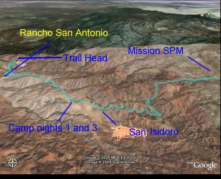
) It was actually closer to 10 miles by foot and took 8-9 hours.

David K - 2-5-2007 at 10:08 PM

In Graham Mackintosh's book 'Journey With a Baja Burro' c2001, he really wanted to get to Mision San Pedro Martir. Graham and his burro ('Mision') made the ruins at San Isidoro their base camp in hopes of getting to the mission from there (Ch. 17).

The winter of '97/'98 was an El Niño year, and the rain and swollen streams played havock with their journey agenda.

Graham tried to find the padre's road to the mountain mission several times without luck... Enough freezing nights in a tent, he took Mision to San Quintin where Cielito Lindo's Dave & Juanita treated them like celebrities!

San Isidoro on Baja Atlas

David K - 2-8-2007 at 11:03 PM

Here is the area including the graded road to Nueva York/ San Quintin and shows the 'Trail of Tears' to San Isidoro.

Added is the new road that continues beyond the San Isidoro trail and heads way south to join the La Suerte road, and the trail to Mision San Pedro Martir. Using Google Map Satellite images, I could see it in many places along the route hiked by Jack Swords, Taco de Baja, Mexitron, Pappy and others...

Isidoro-SPM-r.JPG - 45kB

David K - 5-23-2008 at 02:02 PM

Bump

David K - 12-1-2015 at 09:49 AM

Bump-2 for the current discussion on San Isidoro and the new road in the sierra foothills.