To the La Turquesa Canyon viewpoint and steep grade down.
This trail has been reported as ultra tough for motorcycles and the route is one of Kacey Smiths Baja GPS Guidebook chapters called the XR Ride.
What I found was an old mine (?) road, perhaps from the pre pavement days. It seemed that it could easily be passable with a little rock moving, at
least halfway down the grade. If I were with another vehicle, I would have attempted the drive down As it was, I walked just over a mile from the top
and seemed to be at least halfway to the bottom. Baja Angel thought this unmapped road was really cool and said she would have no problem driving her
CJ-5 Jeep on it.
From the point I quit hiking down, the road curved out of view, so it couldnt be determined if it was passable to me without a companion vehicle for
any problems. However, it would make an excellent quest for Ken Cooke and his Rubicon Jeep Club and the Squarecircles new Land Rover who will always
jump at the chance to tackle a new off road adventure!
To find the La Turquesa Grade:
On Highway One going south, a short distance south of the boulder pile known as El Pedregoso, just past Km. 213, about 97 ½ miles from El Rosario
Pemex, a track heads east in a rock filled arroyo. GPS (NAD27 Mexico) is 29 degrees 31.143, 114 degrees 29.986 (elev. 2,482). Coming north on Hwy.
1, you will go about 12 ½ miles from Laguna Chapala and turn east just past the Km. 214 marker.
A tree is near the place you leave the highway and road construction tank is just north of the arroyo road drive east in the rock filled arroyo
eventually leaving the arroyo for a smoother ride. The drive to the peninsular divide/ top of the grade is 4.6 miles and took us 27 minutes (moving
time). At the top of the grade a concrete claim monument is there: 29 degrees 32.531, 114 degrees 26.023 (elev. 2,816). Get out and have a look
down! Baja Angel and I hiked a ways down together and I continued to a point over a mile from the top at 29 degrees 32.704, 114 degrees 25.722
(elev. 2,379).
After returning to my truck, Baja Angel and I pulled out our camp chairs and enjoyed beer with cheese and crackers then it was off to Gonzaga Bay.
Too bad we werent sure about the shortcut down La Turquesa Canyon, as it would have cut off over 30 miles!
Photo of rocky road in arroyo 0.4 mile from Highway 1:
[Edited on 2-22-2007 by David K]
David K - 2-20-2007 at 09:43 PM
Better road, photo taken 3.0 miles from Highway 1:
David K - 2-20-2007 at 09:44 PM
The top of the grade on the peninsular divide, 4.6 miles from Highway 1:
Zoom in on where I think the turquoise mine is located:
[Edited on 2-21-2007 by David K]
David K - 2-20-2007 at 09:49 PM
My truck at the top of the grade... note concrete monument of some mine claim, I imagine...
David K - 2-20-2007 at 09:50 PM
The old road leading down into the canyon:
David K - 2-20-2007 at 09:51 PM
Noticed many m/c tracks on it (DEVEAU's maybe?)...
David K - 2-20-2007 at 09:52 PM
Really a nice view... In the area of granite boulders beyond the canyon is Highway 5 between Gonzaga Bay and Coco's Corner:
David K - 2-20-2007 at 09:53 PM
I zoom in on Baja Angel from where I hiked down to (she hiked a good 3/4 mile with me, then I went a bit over a quarter mile more, hoping to see the
bottom half of the road):
[Edited on 2-22-2007 by David K]
David K - 2-20-2007 at 09:55 PM
It really doesn't look that tough for a four wheeler... However, the bottom half is the unknown!
David K - 2-20-2007 at 09:56 PM
Zoom in on the wash at the bottom of the grade... I could see m/c tracks in it:
David K - 2-20-2007 at 09:57 PM
I begin the hike back up...
David K - 2-20-2007 at 09:59 PM
I really like the old roads in Baja... I wonder if it was turquoise that paid for the construction here?
[Edited on 2-21-2007 by David K]
David K - 2-20-2007 at 10:02 PM
I sure want to go back and try it out... Who wants to as well?
David K - 2-20-2007 at 10:03 PM
One last look at the view!
David K - 2-20-2007 at 10:07 PM
Map of the area
Von - 2-20-2007 at 10:21 PM
Thats really cool David.
Thanks for all the info, maybe someday we can make all the way through?
Let me know I have a 2004 4x4 F150 thats just waiting for a challege.......David K - 2-20-2007 at 10:52 PM
I just went back to the satellite image and could see exactly where Baja Angel and I hiked to... and it was at least halfway down... I hope this shows
up well:
Map of La Turquesa Grade...
Okay, looks great, all the photos of the grade (above) were taken between 'Top' and 'End of Hike, 1.1 mile from top'...
[Edited on 2-21-2007 by David K]
Neal Johns - 2-20-2007 at 10:59 PM
Thanks, DK. You get the Good Dog award!David K - 2-20-2007 at 11:02 PM
Neal, the Squarecircle already called me to say he's in! You need to come too because it may take two Toyotas to get his pretty new Land Rover
through!!!
[Edited on 2-21-2007 by David K]Bob H - 2-20-2007 at 11:09 PM
OH MY, If I could only make this treck in the cabover.... I know Hook could!
Bob H
other side
John M - 2-21-2007 at 09:03 AM
David, have you or anyone you are aware of scouted this route from the other end?
I'm ignoring Neal's phone calls - I feel there is an impending change in our plans and he'll give this a go - in just a little over a week.
John MTMW - 2-21-2007 at 09:22 AM
David come down for the SF250 race and we'll check it out together after the race. Maybe Ken and some Jeepster will come too. They can move the rocks
out of the way for my Toyota.Hook - 2-21-2007 at 09:23 AM
Quote:
Originally posted by Bob H
OH MY, If I could only make this treck in the cabover.... I know Hook could!
Bob H
I dream about it.......but exploratory runs are not the Lance's forte. Let these boys scout it first in their Taco rockets.
I have to say, though, that the Google Earth images of the area do not look promising and it's pretty high res stuff. The Mission Santa Maria route
looks more promising from the images but we all know how that one end's up.DEVEAU - 2-21-2007 at 10:36 AM
I think you guys will have fun working on this one. I would start on the Hwy #1 side for the first time, much easier to find the start. Do NOT go past
anything on the eastern downhill you can't get back up. There are a couple wash-outs near the bottom that might be a problem for a 4-wheeler.
As Kacey says, keep on the left side of the wash going out. There is a old mine up on the left wall, when you see it you are out of the hard part. At
the end you will cross over to the right side of the wash and should be easy to follow the road out from there.
Have Fun!David K - 2-21-2007 at 10:50 AM
Thanks for the tips DEVEAU!
That was the reason I didn't take my Tacoma down it last Saturday... I didn't hike all the way to the bottom to confirm if there was some short cliff
at the end... I had just enough energy to hike back up the 1.1 miles and 500' elevation gain, after hiking down!
From there to the green pools you can make out the road on the satellite image (I hiked it to the mine because I could not see it from the Green Pools
in '75). The pools to Mex. 5 is easy!
The washouts you mention could be filled with all the loose rock I bet!
[Edited on 2-21-2007 by David K]Gadget - 2-21-2007 at 12:35 PM
Let me know a couple days in advance when you want to try it David and I'll see if I can clear my schedule.Pappy Jon - 2-21-2007 at 12:39 PM
Quote:
Originally posted by David K
I sure want to go back and try it out... Who wants to as well?
ME, ME ... pick ME! That looks too cool. Turquesa Canyon is one of my favoriate places to camp. I don't recall a road going up past the mine, but
then, I really never looked. WOW!David K - 2-21-2007 at 12:46 PM
Awesome!!!
Baja is a cure for ills of civilization, and by posting these photos of new places I visit inspires others to explore, then that is great.
Now, I known soon someone will say this will lead to grafitti or enviromental damage... I trust the Nomads and people who love Baja for its back
country adventures are not the ones who do these things.
Jon, you and Gadget, Squarecircle, TW, Von, and others have at it! If I can get away too, then I will be there with you!
Jon, you and Gadget, Squarecircle, TW, Von, and others have at it! If I can get away too, then I will be there with you!
Viva Baja!
Actually, I'm in Baja mode now. Sixteen days and counting before 3 nights at Shari's and 10 days camping. My first night will be in Turquesa Canyon
from the bottom. I love photographing the pools.
This trip I'm going to visit a beach (that I won't mention right now) that I can follow a road to on Google Earth. Never heard anybody talk about it,
though David, you were close once. This might just be my little secret.
[Edited on 2-21-2007 by Pappy Jon]David K - 2-21-2007 at 03:40 PM
Great! Here's my son at the pools of La Turquesa back in 2002...
I have followed some cool roads on Google that are just begging to be explored... Also, you can easily follow the El Camino Real across the desert
between Santa Gertrudis and San Borja much of the way!
I will u2u you a road I spotted that goes to the gulf... maybe it's the same?MoFish - 2-21-2007 at 09:08 PM
hey David K. My son and I will be in Gonzaga at papa Fernandez 3-08 to 3-13 we have of couple of dirt bikes if you need a couple of newbie scouts. RobDavid K - 2-22-2007 at 12:20 AM
Cool deal MoFish... If it is too windy to fish, then check it out... The bottom half needs to be photographed so us in four wheelers know what we can
tackle. It's about 2 miles west of the Green pools...bajalou - 2-22-2007 at 08:10 AM
Quote:
Originally posted by David K
Cool deal MoFish... If it is too windy to fish, then check it out... The bottom half needs to be photographed so us in four wheelers know what we can
tackle. It's about 2 miles west of the Green pools...
Where's ArvadaGeorge with his helmet cams when you need him???David K - 2-22-2007 at 10:09 AM
Quote:
Originally posted by bajalou
Quote:
Originally posted by David K
Cool deal MoFish... If it is too windy to fish, then check it out... The bottom half needs to be photographed so us in four wheelers know what we can
tackle. It's about 2 miles west of the Green pools...
Where's ArvadaGeorge with his helmet cams when you need him???
Lou, can you or another Nomad with the 3-D Google Earth ability provide a look at the grade's lower end from the east?
Turquesa Mine road off hwy 5
TMW - 2-24-2007 at 10:51 AM
Road toward the Mine
TMW - 2-24-2007 at 10:52 AM
Mine area looking west
TMW - 2-24-2007 at 10:53 AM
Past the mine toward the Trail
TMW - 2-24-2007 at 10:54 AM
Closer to the trail
TMW - 2-24-2007 at 10:54 AM
Wash meets Trail
TMW - 2-24-2007 at 10:59 AM
TMW - 2-24-2007 at 10:59 AM
From the mine up the wash to the trail is a climb of about 300 feet.David K - 2-24-2007 at 11:12 AM
Keep going Tom, these are GREAT!!!
Up the trail
TMW - 2-24-2007 at 11:22 AM
Up some more
TMW - 2-24-2007 at 11:23 AM
Up More
TMW - 2-24-2007 at 11:24 AM
Keep Going
TMW - 2-24-2007 at 11:25 AM
On to what look to be a Plain
TMW - 2-24-2007 at 11:26 AM
Further West
TMW - 2-24-2007 at 11:27 AM
Low Res to hwy1
TMW - 2-24-2007 at 11:28 AM
Hwy 1 at top
TMW - 2-24-2007 at 11:28 AM
TMW - 2-24-2007 at 11:33 AM
The mine area is around 1700 feet and the trail peaks at about 2800+ then drops back to around 2500 feet toward the hwy. These are approximate
elevations.
[Edited on 2-24-2007 by TW]
Overall Points
TMW - 2-24-2007 at 11:53 AM
David K - 2-24-2007 at 11:57 AM
I parked my truck at the top of the ridge in your 10:26 am post photo (on to what looked to be a plain)... Excellent TW!!!
Friday the 23rd
bajalou - 2-24-2007 at 12:01 PM
Some people just can't wait. Told a few neighbors about it and they had to go yesterday. - Remember, we're in Baja Bugs and desert rails - no MCs.
There is a road into the mouth of the canyon from Hghy 5 but we only found it on our way out.
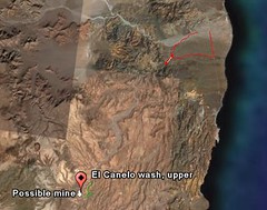
This shows where we went - from Matomi to the canyon and back out to the highway. (red) and points for the mine and upper canyon near the lower left.
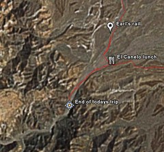
This shows our gong into the mouth - about a mile from the lunch spot.
There were motorcycle tracks going on beyond where we went. Because of a broken axle on a rail and time of day we turned around there but know we can
drive further up the canyon on another day. Where we stopped we were at about 635 ft elevation. Longer days will help when we go back again.
[Edited on 2-24-2007 by bajalou]TMW - 2-24-2007 at 12:21 PM
Lou when I come down for the race we're going to check it out.bajalou - 2-24-2007 at 06:28 PM
When are you coming down Tom?TMW - 2-25-2007 at 10:18 AM
We're going to start down on Thursday the 8th. I don't know if we'll be there Thursday evening as I want to try another route into the plane wreck we
found last July. We'll be in San Felipe Friday morning for contingency then maybe check out the wash after lunch. The road you found was it south of
Matomi?
[Edited on 2-25-2007 by TW]David K - 2-25-2007 at 10:33 AM
Quote:
Originally posted by bajalou
Some people just can't wait. Told a few neighbors about it and they had to go yesterday. - Remember, we're in Baja Bugs and desert rails - no MCs.
There is a road into the mouth of the canyon from Hghy 5 but we only found it on our way out.
This shows where we went - from Matomi to the canyon and back out to the highway. (red) and points for the mine and upper canyon near the lower left.
This shows our gong into the mouth - about a mile from the lunch spot.
There were motorcycle tracks going on beyond where we went. Because of a broken axle on a rail and time of day we turned around there but know we can
drive further up the canyon on another day. Where we stopped we were at about 635 ft elevation. Longer days will help when we go back again.
[Edited on 2-24-2007 by bajalou]
Lou,
You are showing something different than the La Turquesa Canyon route... which is between Gonzaga and Coco's Corner. Your route looks to be on or near
the Bill Nichol's Trail, which starts about 8 miles south of Puertecitos...?
I am interested in this route as well, perhaps start a new thread in the Off Road or Trip Reports Forum to make it easy to find on Nomad... and make
the images larger, please???bajalou - 2-25-2007 at 10:36 AM
See you at contingency - but the coords for the turn from H5 are
30 27.4765 -114 39.4075
That is Deg and min only
There is a white van just off the highway right where you turn in on the road. One "Y" in the road a mile or so in, stay to the right. The road
eventually crosses the El Canelo wash about 1/2 mile from the mouth of its canyon.
From H 5 it is about 22 miles to the curve nearest the mine. (Made a track in GoogleEarth, converted to Ozi to get measurement).
If you get here earlier, come on by.bajalou - 2-25-2007 at 10:39 AM
Quote:
Originally posted by David K
You are showing something different than the La Turquesa Canyon route... which is between Gonzaga and Coco's Corner. Your route looks to be on or near
the Bill Nichol's Trail, which starts about 8 miles south of Puertecitos...?
I am interested in this route as well, perhaps start a new thread in the Off Road or Trip Reports Forum to make it easy to find on Nomad... and make
the images larger, please???
Just thinking about the thread. My posts etc are regarding TW's El Canelo and mine with roads to H1 post.David K - 2-25-2007 at 10:43 AM
Lou, TW's Google Earth pictures are of the road to the Green Pools and past the Turquoise Mine to the trail Baja Angel and I hiked partway down last
weekend (what this thread is about)... Kacey Smith's XR Ride/ Coco's Shortcut.bajalou - 2-25-2007 at 10:58 AM
Sorry David, guess TW's post about this was in another thread -David K - 2-25-2007 at 11:02 AM
No worries Lou... I do want to see more of the trail you are talking about!
A short cut between Hwy. 1 and 5 is what we seek... The La Turquesa Canyon route is only 12 miles north of Chapala, so is not that great of a
benefit... However, a route closer to Puertecitos like the one you showed would be a great way to save over 100 miles of driving!
[Edited on 2-25-2007 by David K]David K - 2-27-2007 at 08:21 PM
If it helps you explorers find the bottom of the grade in La Turquesa Canyon better, I bordered the road with a marker... There is a small switchback
at the bottom which puts the point where the old mine road reaches the arroyo to the north of the Trail-1 dart in TW's awesome images...