BajaNomad

El Canelo wash

bajalou - 2-25-2007 at 11:01 AM

TW mentioned in another thread a mine he found on Google Earth near the upper reaches of El Canelo was in the Sierra Santa Isabela west of Puertecitos. I drew some possible routes as tracks in Google Earth and transfered them to Ozi Explorer.

This is north of the Bill Nichols trail, leaving Hghy5 between the Matomi and Puertecitos.

Some people just can't wait. Told a few neighbors about it and they had to go yesterday. - Remember, we're in Baja Bugs and desert rails - no MCs. There is a road into the mouth of the canyon from Hghy 5 but we only found it on our way out.

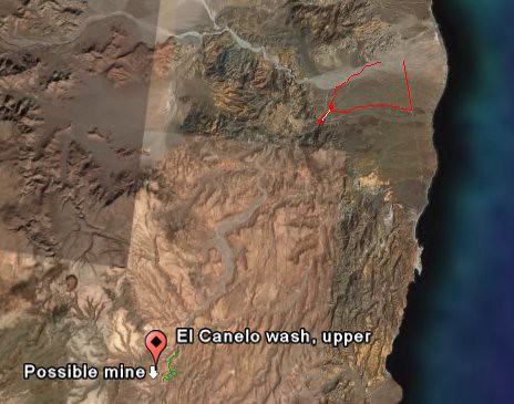
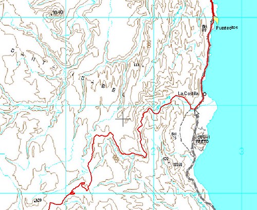
This shows where we went - from Matomi to the canyon and back out to the highway. (red) and points for the mine and upper canyon near the lower left.


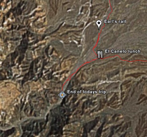
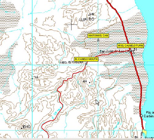
This shows our gong into the mouth - about a mile from the lunch spot.


There were motorcycle tracks going on beyond where we went. Because of a broken axle on a rail and time of day we turned around there but know we can drive further up the canyon on another day. Where we stopped we were at about 635 ft elevation. Longer days will help when we go back again.

The coords for the turn from H5 are
30 27.4765 -114 39.4075
That is Deg and min only
There is a white van just off the highway right where you turn in on the road. One "Y" in the road a mile or so in, stay to the right. The road eventually crosses the El Canelo wash about 1/2 mile from the mouth of its canyon.

From H 5 it is about 22 miles to the curve nearest the mine. (Made a track in GoogleEarth, converted to Ozi to get measurement).


[Edited on 2-25-2007 by bajalou]

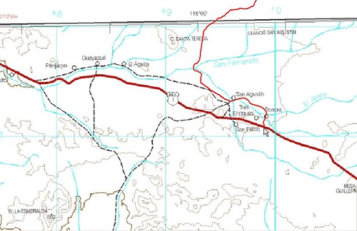
Bill Nichols Trail

bajalou - 2-25-2007 at 11:14 AM

Here is the Bill Nichols trail on Google Earth


El Canelo

TMW - 2-25-2007 at 11:52 AM

Thanks Lou here's some more satellite images from hwy 5 at Matomi to the mine.

El Canelo 1.jpg - 48kB

El Canelo

TMW - 2-25-2007 at 11:54 AM


El Canelo 2.jpg - 48kB

El Canelo

TMW - 2-25-2007 at 11:55 AM


El Canelo 3.jpg - 48kB

El Canelo

TMW - 2-25-2007 at 11:56 AM


El Canelo 4.jpg - 48kB

Mine

TMW - 2-25-2007 at 11:57 AM


El Canelo 12.jpg - 48kB

El Canelo

TMW - 2-25-2007 at 11:58 AM

[Edited on 2-25-2007 by TW]

[Edited on 2-25-2007 by TW]

El Canelo 5.jpg - 49kB

El Canelo

TMW - 2-25-2007 at 12:00 PM


El Canelo 6.jpg - 49kB

El Canelo

TMW - 2-25-2007 at 12:00 PM


El Canelo 7.jpg - 48kB

El Canelo

TMW - 2-25-2007 at 12:01 PM


El Canelo 8.jpg - 47kB

El Canelo

TMW - 2-25-2007 at 12:02 PM


El Canelo 9.jpg - 49kB

El Canelo

TMW - 2-25-2007 at 12:03 PM


El Canelo 10.jpg - 48kB

El Canelo

TMW - 2-25-2007 at 12:04 PM


El Canelo 11.jpg - 43kB

TMW - 2-25-2007 at 12:13 PM

In the Almanac it's on page 14. The mine is at 30-15-10x114-50-25 @ 2128ft. Located on page 14 at the bottom near the 114.50 mark. If you use Google Earth you can trace the road at the mine back to hwy 1 in the Guayaquil area. I'm sure the road is the same as used in the Bill Nichols trail.

bajalou - 2-25-2007 at 01:21 PM

TW, I've also traced the road from the mine to H1 and it is north of the Bill Nichols trail - I had both on the same GoogleEarth image.

The entry to El Canelo is not the best resolution. Higher resolution as you go on south in the canyon. By width etc I believe the first 4-5 miles will be the toughest as it widens out later.


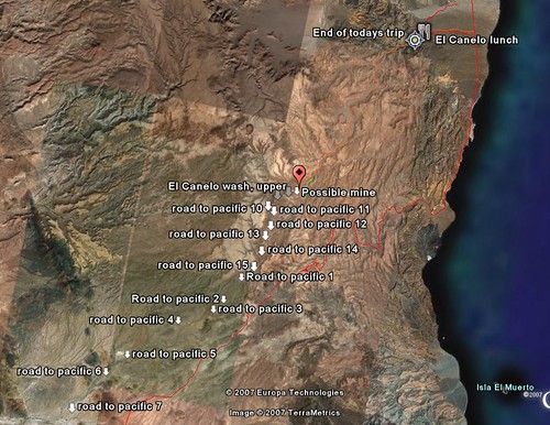
The "Road to Pacific 7" is where the mine road connects with Hghy1. The red track starting below Puertecitos is the Bill Nichols Trail.

[Edited on 2-25-2007 by bajalou]

TMW - 2-26-2007 at 07:47 AM

Lou can you overlay Bill Nichols trail in closeup quarter sections. The bottom half is easy to follow as you can see the road on the satellite images. But the top half is difficult because it appears he followed various washes and the satellite images don't show any tracks that I could see.

surfer jim - 2-26-2007 at 02:07 PM

I am watching this wishing I was driving it......love those images....

ArvadaGeorge - 2-26-2007 at 04:15 PM

Lou
What were the cords for "end of today trip" and "earls rail" ???
I think I have done some riding there.
And I have done Bill's trail several times

Mexitron - 2-26-2007 at 04:48 PM

Bajalou--where does the Bill Nichols trail end up at? Not familiar with it.

Bill Nichols Trail

bajalou - 2-26-2007 at 06:47 PM

Quote:
Originally posted by Mexitron
Bajalou--where does the Bill Nichols trail end up at? Not familiar with it.


A motorcycle trail from Hghy 1 to Sea of Cortez south of Puertecitos


And from the Hghy 1 end


El Canelo

bajalou - 2-26-2007 at 06:58 PM

Quote:
Originally posted by ArvadaGeorge
Lou
What were the cords for "end of today trip" and "earls rail" ???
I think I have done some riding there.
And I have done Bill's trail several times


I figured you probably have gotten in there, George, might be your tracks we found.

the waypoint "El Canelo Mouth" is at 30 26.696 -114 43.670 Near our End of trip marker is on other map.


David K - 2-26-2007 at 07:02 PM

The end on Hwy. 1 is on the El Marmol road jcn. by Sonora...

What I would like to know Lou or TW, is where does that mine road reach Hwy. 1???

Gracias!

TMW - 2-26-2007 at 07:10 PM

David I followed it back to Guayaquil. There are cross roads that you could follow to the San Quintin area too.

David K - 2-26-2007 at 07:13 PM

Thanks TW, I will get on Google satellite this week and fly over it! I hope it goes through! Great shortcut... finally!!!

[Edited on 2-27-2007 by David K]

TMW - 2-26-2007 at 07:29 PM

Getting 4 wheelers to the mine thru the wash may require Ken and his merry men and women.

Mexitron - 2-26-2007 at 08:08 PM

Thanks Bajalou--wow, looks like fun!

bajalou - 2-26-2007 at 08:35 PM

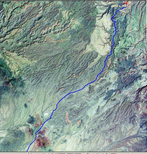
I plotted the road from the mine to Hghy 1 near El Aguila as 30 miles. The last few miles there are more choices so ???

The red at the top is the part of El Canelo nearest the mine. The blue is the road most of the way to Hghy 1


[Edited on 2-27-2007 by bajalou]

bajalou - 2-26-2007 at 08:37 PM

Quote:
Originally posted by TW
Getting 4 wheelers to the mine thru the wash may require Ken and his merry men and women.


The first portion I think might be the toughest? Then getting from the wash up to the mine.

David K - 2-27-2007 at 11:22 AM

On the Almanac Map 16, it seems the road from Hwy. 1 to the mine follows Arroyo El Roņoso... So the gap is pretty tiny between the mine and Arroyo El Canelo! I wonder how that little canyon is that makes the gap!!!

John M and Neal Johns... you guys like mines, don't you? :bounce::lol:

Ken Cooke, ... here's your stress relief project! Also that La Turquesa Canyon short cut! :)

bajalou - 2-27-2007 at 01:30 PM

Quote:
Originally posted by David K
So the gap is pretty tiny between the mine and Arroyo El Canelo! I wonder how that little canyon is that makes the gap!!!


Half mile from the mine spot to the curve in El Canelo that TW originally marked. Also, a south branch of El Canelo comes within 1/2 mile on the other side. Not very far at all is it? But how many feet in elevation do you have to gain? And how steep?

David K - 2-27-2007 at 04:00 PM

Lou, when you find out... let us know!;):lol::yes:

Mine Elevation

TMW - 2-27-2007 at 04:19 PM

The mine is about 250 feet higher than the wash.

Mine Elevation.jpg - 44kB

David K - 2-27-2007 at 06:19 PM

Great... I hiked down and back up 500 feet checking out the Turquesa grade with Baja Angel, so 250 feet 'ain't no thing'!

Ken Cooke - 2-27-2007 at 10:05 PM

Quote:
Originally posted by David K
Ken Cooke, ... here's your stress relief project! Also that La Turquesa Canyon short cut! :)


My stress relief project is 5'0, has long brown hair w/a slight Spanish accent, a perfect smile, and a personality to match. No worries or stress at the moment - I'm feeling the benefits of divorce at the moment...:yes:

Back to Jeepin'. We've got a built CJ-7 that will be leading runs at Easter Jeep Safari which will be ready for some action. Andrew wants some prime 'wheeling, and this sounds like it will be promising. My Jeep speaks for itself. Dents, dings, and Baja Bling.

Mike's '07 Long-Wheelbase Rubicon is the trail virgin in search of some sin.

I will be inviting more capable Jeepers on this trip along with my friend with the Ford Explorer which is going EXTREME. This will not be a "run" where people show up expecting everything to be done for them. Mentally, that is not where my mind is at this point. I'm looking for fun and adventure along with a release from the moment. Checking out some new digs south of the border sounds like the kind of fun that will lure me back to my two most favorite things - tough 4 wheeling and BAJA, CALIFORNIA.

David K - 2-28-2007 at 12:08 AM

That's the spirit!

Oh, don't forget to pay your mordida... Remember the last time you tried to get past the policia in Baja???:lol::light:

[Edited on 2-28-2007 by David K]

Viva Baja Cactus 070r.JPG - 39kB

Ken Cooke - 3-1-2007 at 10:20 PM

Nice photochop picture, David! You know that never happened!?! :lol:

David K - 3-1-2007 at 10:21 PM

The black man just has no chance, does he Ken!???:biggrin::tumble:

Ken Cooke - 3-2-2007 at 10:13 PM

Quote:
Originally posted by David K
The black man just has no chance, does he Ken!???:biggrin::tumble:
I could have taken both of them...easy. It just so happens that I am a nice, gentle guy... :spingrin:

Ken Cooke - 3-2-2007 at 11:39 PM

3 Jeeps are on the ready at the moment. Just keep us posted. We're heading to San Felipe on April 8th, and will be ready to explore on the 9th. Just keep us posted...

David K - 3-2-2007 at 11:44 PM

Awesome Ken...

Gadget - 3-3-2007 at 09:17 PM

Quote:
I will be inviting more capable Jeepers on this trip along with my friend with the Ford Explorer which is going EXTREME. This will not be a "run" where people show up expecting everything to be done for them. Mentally, that is not where my mind is at this point. I'm looking for fun and adventure along with a release from the moment. Checking out some new digs south of the border sounds like the kind of fun that will lure me back to my two most favorite things - tough 4 wheeling and BAJA, CALIFORNIA.


Ken,
You've seen a photo of my Bronco pre-runner and I'm pretty sure I've mentioned that I also own a Grand Cherokee so I do have some Jeep blood. Perhaps you guys wouldn't mind a big Ford product tagging along with you on this one since one of it's smaller siblings is invited. We're no worries and fully self contained for the whatevers of Baja. I am very interested in scouting these shortcut cross over trails.

Ken Cooke - 3-4-2007 at 02:45 AM

Quote:
Gadget,

No problem if you'd like to be in on this trip. I am not listing it as a, "Run" because I don't want the hassles/worries of leading a group run, and because this trip is simple therapy...

Quote:
Originally posted by Gadget
I will be inviting more capable Jeepers on this trip along with my friend with the Ford Explorer which is going EXTREME. This will not be a "run" where people show up expecting everything to be done for them. Mentally, that is not where my mind is at this point. I'm looking for fun and adventure along with a release from the moment. Checking out some new digs south of the border sounds like the kind of fun that will lure me back to my two most favorite things - tough 4 wheeling and BAJA, CALIFORNIA.


Ken,
You've seen a photo of my Bronco pre-runner and I'm pretty sure I've mentioned that I also own a Grand Cherokee so I do have some Jeep blood. Perhaps you guys wouldn't mind a big Ford product tagging along with you on this one since one of it's smaller siblings is invited. We're no worries and fully self contained for the whatevers of Baja. I am very interested in scouting these shortcut cross over trails.

Gadget - 3-4-2007 at 04:35 PM

Ken,
Copy that. Please keep us posted on a confirmed departure date so we can determine who will be riding co-dog with me. That's all I need. E-mail me direct if you want.

Ken Cooke - 3-4-2007 at 08:50 PM

Departure from Riverside, CA is Sunday 4/8/07 - arriving in San Felipe at night. Staying until Thursday 4/12/07 - returning to Riverside, CA.

Gadget - 3-6-2007 at 05:55 PM

Ken,
Please go to you U2U

Ken Cooke - 3-12-2007 at 10:02 PM

El Canelo gang:

1. Gadget in his raced-out Bronco
2. Andrew in his built CJ-7 on 36" TSL Swamper Radials
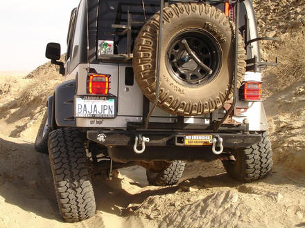
3. Ken in his 'BAJAJPN' Rubicon
4. MadMike in his '07 Unlimited Rubicon

Talk about a diverse group! This should be a blast in the desert. I can't wait to start snapping digital photos of all of the rocks we are bound to encounter! :bounce:


Ken Cooke - 4-4-2007 at 07:06 PM

Our crew is assembled. There will be 3 Jeeps and 1 Toyota on this trip. All 3 Jeeps are lifted, locked, 4:1 gear reduction, mud-terrain tires, etc. The Toy is built to tackle the Sierras, so we can't wait to see how it works in Baja.

Our plan is to tackle Smuggler's Canyon on Sunday, and then pack up and drive to San Felipe for showers and beer. Then, Canelo Wash with Baja Lou. It should be a blast.

David K - 4-4-2007 at 08:14 PM

Have fresh batteries in your GPS Ken!

If it is a no go through Canelo to the mine, then go south to Turquesa Canyon and make the way from the turquoise mine to the grade, and up!

Remember, after the turquoise mine, stay to the right (north) side of the wash... It should only be a mile to the bottom of the grade!

Here are the photos (also in the trip report here on Nomad):

http://community-2.webtv.net/boojum1/207

[Edited on 4-5-2007 by David K]

La Turquesa-r.JPG - 41kB

Ken Cooke - 4-4-2007 at 10:45 PM

Thanks for the info. I can't wait to see this area. On Day #1, we plan to tackle Smuggler's Canyon.

As you can see, we have ourselves plenty of off-road fun planned for the next several days...:bounce:

David K - 4-5-2007 at 08:00 AM

Looks like Copper Canyon of mainland Mexico (great pictures)... The few in the beginning of you Jeepers climbing on a junk car and some granite must be this 'Smugglers Canyon'? Where is that?

Ken Cooke - 4-5-2007 at 08:29 PM

Quote:
Originally posted by David K
Where is that?


Its our secret. Bring your Toyota out to play with us, and we'll take you there. I couldn't believe how much traction that granite provides a set of tires. Look forward to more pictures when we return...

Ken Cooke - 4-5-2007 at 08:33 PM

Turquesa is too far south. We want this to be an easy trip - 4 wheeling during the day, and plenty of fun and drinking during the night. We'll see what those Jeeps and lone Toyota can do in Canelo...


[Edited on 4-6-2007 by Ken Cooke]

Gadget - 4-7-2007 at 11:57 AM

I wish the moderator would pull this aggravating post from the board so I don't have to look at it any more since I can't go :no::no::no: Seriously, guys have fun and be safe. Will hook up GSB with you Jeepers on the next one and you can see what a FoMoCo will do. Granted, as I'm sure there is much snickering going on regarding that comment, I have spent 10s of thousands of dollars on the Bronco to make it work. It was barely worth didily when it was stock :spingrin: and yes, now I have chapped the purest, Ford guys hides, sorry, just a little clowning here.
And David, don't forget to get ahold of me for the La Turquesa when you want to do a Fri - Sun run on it, OK!

[Edited on 4-7-2007 by Gadget]

Ken Cooke - 4-7-2007 at 02:13 PM

It looks like we have a full day of HARDCORE 4'wheeling on Sunday which makes me VERY happy. Tuesday, we have a 2nd day of HARDCORE 'wheeling as well, so, this looks to be a really fun and great trip south of the border - my 4th in a month! :bounce:


[Edited on 4-7-2007 by Ken Cooke]

David K - 4-8-2007 at 08:58 PM

Quote:
Originally posted by Gadget
I wish the moderator would pull this aggravating post from the board so I don't have to look at it any more since I can't go :no::no::no: Seriously, guys have fun and be safe. Will hook up GSB with you Jeepers on the next one and you can see what a FoMoCo will do. Granted, as I'm sure there is much snickering going on regarding that comment, I have spent 10s of thousands of dollars on the Bronco to make it work. It was barely worth didily when it was stock :spingrin: and yes, now I have chapped the purest, Ford guys hides, sorry, just a little clowning here.
And David, don't forget to get ahold of me for the La Turquesa when you want to do a Fri - Sun run on it, OK!

[Edited on 4-7-2007 by Gadget]


Gadget, that's a deal... and Roy (The Squarecircle) is ready to go too and get his new Land Rover dirty, the right way!

Ken Cooke - 4-12-2007 at 09:55 PM

Just back from the El Canelo wash expedition, I am amazed at how well Baja Lou's VW Buggy kept up with our built Jeeps! He was able to go literally everywhere our Jeeps could go - with ease.

We could not reach the mine, due to the fact that the rocks kept getting bigger, and I did not want to keep smacking my differentials and gas tank skid plate on those things. I slid off of a rock on my steering knuckle, and my front differential kept getting hit throughout the day-long trip.

Lou, his friends Bruce and Wes were great people. Too bad I have to work everyday for a living - otherwise, I'd spend the rest of the spring in San Felipe instead!:light:

TMW - 4-13-2007 at 07:09 AM

So how far did you get? GPS reading.

surfer jim - 4-13-2007 at 07:27 AM

Time for bigger tires?.....:lol:

bajalou - 4-13-2007 at 08:12 AM

Here's the end L/L N 30 25.375, W 114 45.656.

I got a couple pf pictures I'll post later with a little report of the great time we had with Ken and friends. We got into the high resolution area on GoogleEarth but not too much farther. The rockfield ahead of us was doable, but slowly, so we chose lunch and a return.


Great trip - and not the last one to this area - got to find the mine for TW

[Edited on 4-13-2007 by bajalou]

bajalou - 4-13-2007 at 08:33 AM

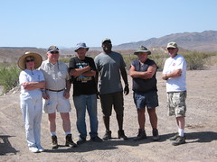
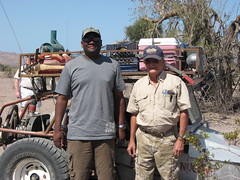
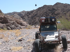
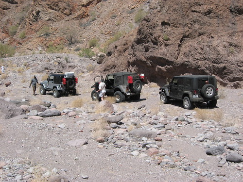
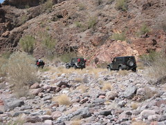
A few pictures I took on the great trip with Ken, Mike, Andrew, and Gretchen in Jeeps and Wes and Bruce in a desert rail.


Bruce and Wes didn't go as far in as the rest of us as they had little faith in how far we would go. As Ken mentioned, I nad no trouble keeping up with the jeeps - one reason - no hanging shocks, steering stuff or differentials. Just skid-plate from one end to the other.


The jeeps had to pick their routes a little more carefully and we were appreciative of Gretchen walking ahead to scout out some of the areas.


It's quite a canyon - sandy in areas and rockfields with the occasional low rock wall to climb.


Let me know when some more of you want to try it - I'm ready to go----

[Edited on 4-13-2007 by bajalou]

David K - 4-13-2007 at 08:37 AM

Lou, I am looking forward to seeing on the map how far you guys got, if you can post one?

Too bad the satellite images don't show rocks big enough to stop Jeeps.

Canelo looked promissing for a short cut across Baja!

Thanks!

bajalou - 4-13-2007 at 08:54 AM

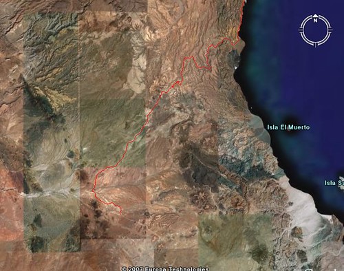
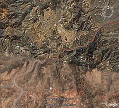
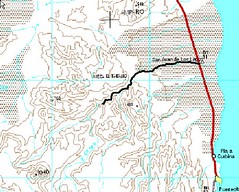
Here is GoogleEarth with our track into the wash. Just barely getting to the High Resolution area.


Still looks like it might be a shortcut to Highway 1 but not a time saver.

Here it is on a topo--


[Edited on 4-13-2007 by bajalou]

Ken Cooke - 4-13-2007 at 01:16 PM

Quote:
Originally posted by bajalou

Still looks like it might be a shortcut to Highway 1 but not a time saver.


I will second that. We were out there under the baking sun for most of the day, and I believe we only traveled a few miles in from Hwy 5. With 40" 'Swampers, it would have been much easier, but I have to garage this Jeep every night, and drive it to work every day.


TMW - 4-13-2007 at 05:37 PM

The fourth pix down looks like where I stopped when I was on my MC. I saw two MC tracks. Could have been one in and out or two bikes going thru, but they would have been much better riders than me.

I think one of those fat tire type BW200 would work in that place better than a regular MC.

[Edited on 4-14-2007 by TW]

TMW - 4-13-2007 at 05:50 PM

My brothers and I will be making our annual Baja trip starting Memorial weekend and I think we will try going in from hwy 1 to the mine and check out that end of the arroyo. I'll have my MC, if there is a way to get into the wash I'll see if it's any better or not.

bajalou - 4-13-2007 at 06:07 PM

Great TW, looking at it from that end wounds great. I agree the fat tired bike would work better at the speeds you have to use here. Some neighbors are thinking of trailering some quads down to the mouth of the wash and trying them.

I believe we passed the last of your tracks. Saw your's as newer than the other pair. Not sure (because of the width of the wash) if we went past the end of them or if they continued.

[Edited on 4-14-2007 by bajalou]

Ken Cooke - 4-13-2007 at 10:43 PM

Quote:
Originally posted by bajalou
I believe we passed the last of your tracks. Saw your's as newer than the other pair. Not sure (because of the width of the wash) if we went past the end of them or if they continued.


Because it started to get so rocky, it would not seem possible to see any of TWs tire tracks going further up the wash.

TMW - 4-14-2007 at 07:38 AM

Wow you guys were right at where the res get good. You were near the second from the left marker labeled Y-gl.

[Edited on 4-14-2007 by TW]

El Canelo 2.jpg - 48kB

Ken Cooke - 4-14-2007 at 12:45 PM

TW, How much farther until we reached the mine?

David K - 4-15-2007 at 10:38 AM

Ken, the first images posted in this thread (page 1) are good to show you where you guys got in the arroyo compared to that mine.

Maybe TW can bribe the miners to do a little bulldozer work when he goes there?:bounce: