
John M - 3-17-2007 at 06:28 AM
When we are heading to Bay of Los Angeles, and get near the San Borja turn-off we have noticed a dry lake off to the left. There are roads leading off
in that direction but we've usually been committed to going to BOLA, and we just keep on driving.
In planning this trip, Neal and I had hoped to go a few places neither of us had been to and so far, about day 4, we had kept to that plan.
In this case Bahia Guadalupe was our destination. TW - on this Board - had posted about the place piquing our interest -and so off we went. The
adventuresome spirit of exploring new places and new roads was tempered a bit by the fact Bill Bryant, a knowledgable Baja traveler was with us, and
he had been here before. Of course not getting too lost is usually a good thing. Bill had friends camped a little ways up the road, a serious ATV
group, with whom we met up with shortly.
Bill led us across the Agua Amarga dry lake (7 miles?), staying along the western portion. Soon the road entered a narrower area, lots of shrubbery -
ocotillo and creosote primarily. We remarked how similar in vegegation to the east Mojave Desert. The vegetation gave way to a narrowing road, winding
through a very scenic and rocky area.
Temperatures had started to rise, into the high 80s, and it wasn't long before we turned to the right off the primary road, entered a sand wash. now
head east toward the gulf.
Incidentelly - Bill offered to continue straight, to another canyon system , and eventually north and east to Punta Candelero. It was at this time the
Bill reminded us that even a little further north, north of the road to Candelero, was one of the areas featured in Erle Stanley Garnder's book -
"Hovering Over Baja" - the Sal Si Puede Canyon in the book, Salsipuedes on today's map. This remains another destination for another trip.
So we headed down toward Bahia Guadalupe - this time in a beautiful canyon, not so narrow, and not so green nor flowery - wrong time of year or more
likely barren due to lack of rain. The rock walls towering on both sides of the wash had a number of what could be called caves - Bill explored one a
hundred feet above the wash.
We left the canyon onto a good road and approached the beach. Several routes take you both north and south, we went straight. We arrived at a small
fish camp and had lunch.
Due to our hope to make it to BOLA and Montevideo yet today we didn't loiter long. Soon is was back on the road, yet again declining the "right turn"
to Punta Candelero.
Enjoy the pictures, next 3 posts.
First is Agua Amarga dry lake, meeting up with Bill's friends.
John M

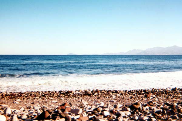
Photo of Bahia Guadalupe
John M - 3-17-2007 at 06:29 AM
attached.

Bahia Guadalupe looking to the north
John M - 3-17-2007 at 06:31 AM
attached
[Edited on 3-17-2007 by John M]

The route
John M - 3-17-2007 at 06:32 AM
Thanks to google earth
John M

Neal Johns - 3-17-2007 at 07:01 AM
Bill drove all the way from Texas to be with us!
Mexitron - 3-17-2007 at 08:13 AM
Great adventure you guys had there...nothing like exploring in Baja!
TMW - 3-17-2007 at 09:18 AM
Great, Thanks for the report and pictures. I plan on going in there the end of May.
Another pic
John M - 3-17-2007 at 09:46 AM
Some of the very few wildflowers we saw along the way to Bahia Guadalupe - in what the Baja Almanac map (on page 21) calls Mesa de Yubay.
John M

one more photo
John M - 3-17-2007 at 09:48 AM
This was at a point nearing the Sea of Cortez. It is in this area that you have a choice of several roads, some heading south, some to the north - all
roads lead somewhere.
In the background, shaded, is Isla Angel de la Guarda.
John M
[Edited on 3-17-2007 by John M]

Hook - 3-17-2007 at 05:36 PM
Looks like you guys were blessed with a minimal amount of wind. Excellent luck in that location at that time of year.
Damn, looks like good holding ground there, just offshore........
Wind??
John M - 3-17-2007 at 06:49 PM
Only the first night north of Tecate was there wind...Very still mostly, great daytime temps in the mid eighties, overnights I say around 50 - tents
were only necessary that first night. We slept on cots under the brilliant canopy of stars and nearly full moon most nights.
Here is a photo, courtesy of Neal Johns, of the canyon leading to Bahia Guadalupe.
thanks Neal.
John M
[Edited on 3-18-2007 by John M]

Barry A. - 3-18-2007 at 09:59 AM
John M-----------this is great stuff!!!
I am sure that most NOMADS have not had the priviledge of travelling these pparticular remote roads------I know I haven't. This opens up a whole new
destination for many of us, and that is really exciting.
I have Gardner's "Hovering over Baja", and have long wondered at the area he visited north of the Yubay area--------some day, hopefully----------I
will go in there, and your post just keeps the dream alive.
Wow great stuff a new dest. for my book..
BAJACAT - 3-18-2007 at 12:47 PM
David K - 3-18-2007 at 08:08 PM
Great area... and when you do go north from the L.A. Bay highway, do drive over the second dry lake (Laguna Seca) and take the road into Arroyo Los
Caneleros... It is super colorfull... better than the Painted Gorge (near Plaster City/ El Centro)!
It takes you to the coast near Punta Candelero... opposite the north end of Isla Angel de la Guarda!
GPS waypoints of these roads are in my GPS page at VivaBaja.com
Here is a photo taken there, looking east at Angel Island...
At the end of Arroyo Los Candeleros the GPS is N29°22.60'/ W113°44.50'. In the distance is the north end of Isla Angel de la Guarda.
Skipjack Joe - 3-18-2007 at 11:36 PM
That bay looks stunningly beautiful. And the road through the canyon is very inviting.
Thanks.
Iflyfish - 3-18-2007 at 11:47 PM
Marvelous! Great pics. What an adventure and well rewarded.
Iflyfish