Tin=Can - 5-4-2007 at 06:38 PM
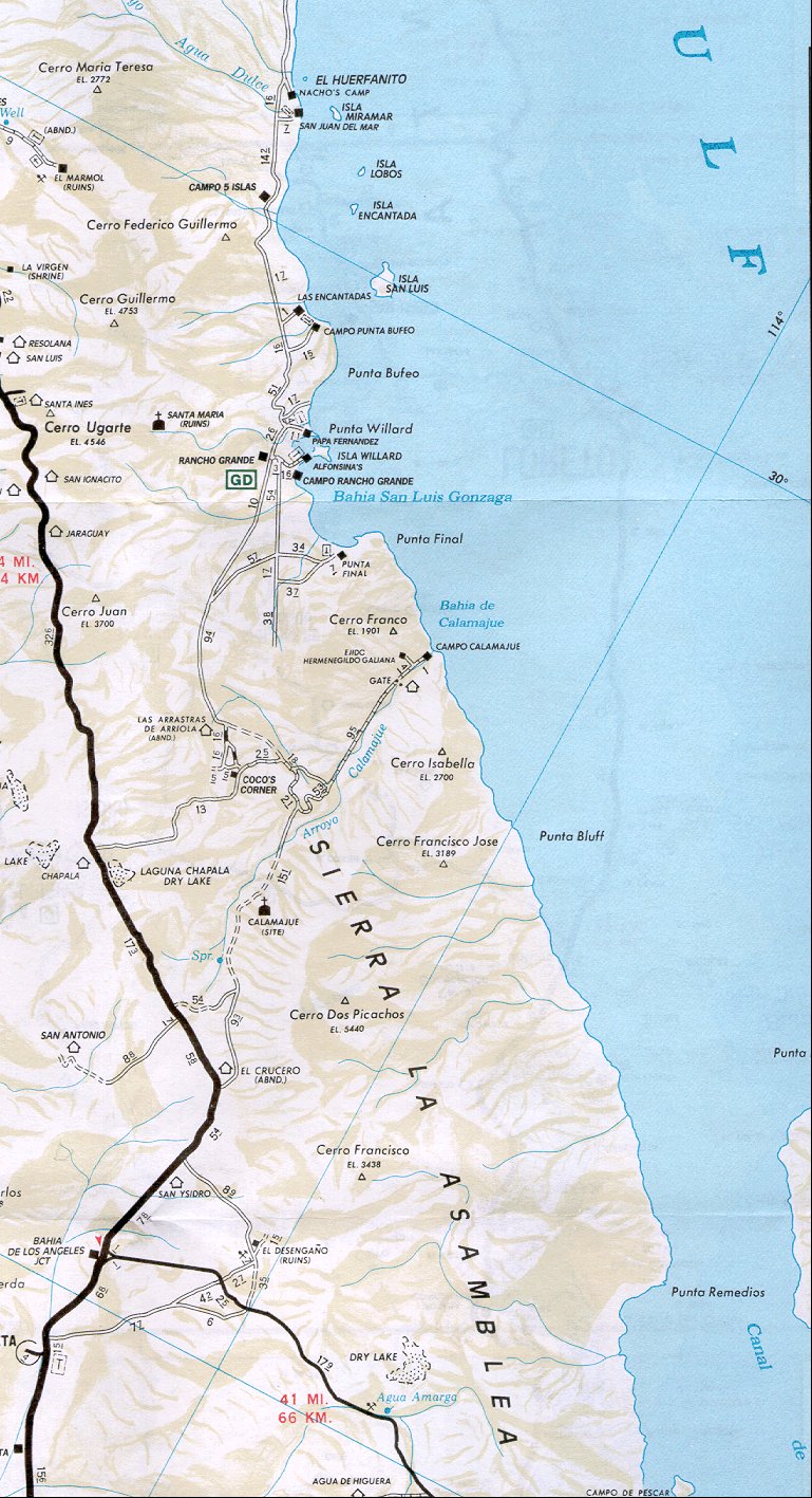
Can somebody tell me where Cocos Corner is located ? Also maybe a good sandy beach to camp at on the Cortez side around Loreto and north on the way
home.
Packoderm - 5-4-2007 at 07:16 PM
Well, first you go straight, then you'll turn a corner. You'll find it there.
Sorry, I couldn't resist.
Packoderm - 5-4-2007 at 07:19 PM
It's between Bahia Gonzaga and Highway 1 - the Transpeninsular Highway.

Bob H - 5-4-2007 at 09:57 PM
GREAT map Pacoderm!
Tin Can... I recommend that on your way North you exit MX-1 at Laguna Chapala dry lake and make your way back via
Coco's Corner (stop and meet him and sign his book) through Gonzaga Bay (an absolutely beautiful area). Stop at Alfonsinas to spend the night or just
to have something to eat and drink some beer. There is also a small cantina at Papa Fernandez place (supposedly run by his grandaughters) and camping
on a beautiful secluded beach. Then make your way North from there through San Felipe. Options after that are going direct to the States via
Mexicali or turning left North of San Felipe to Ensenada then up MX-1 again to the States. It's a nice drive either way.
Send us a trip report when you get back.
Bob H
[Edited on 5-5-2007 by Bob H]
David K - 5-5-2007 at 07:59 AM
See http://vivabaja.com/cocos and http://vivabaja.com/1106/page9.html
Leaving in a few minutes for the Pyramid Resort...
[Edited on 5-5-2007 by David K]
Packoderm - 5-5-2007 at 02:57 PM
I found the map by entering "coco's corner map" in Google and then hit Images. That map was the first image to show up. On the same page, I saw this
sign that caught my eye. The site that contains the sign also has bunches of very interesting photographs of Los Angeles. It is worth a peek. http://www.eleventwentyseven.com/archives/cat_photolog.html


