
David K - 12-24-2007 at 09:44 AM
Inspired by ELINVESTI8 (David), here are my numbers for the road to the old Espinoza ranch area of San Juan de Dios/ El Metate (GPS set to Map Datum
NAD27 Mexico)
HIGHWAY ONE TO SAN JUAN DE DIOS: 21.9 miles, 1.5 hours.
Hwy. 1 (Km. 103 1/2) at turnoff (cafe of 'Los Martires'): 30-03.86', 115-21.06'
Ditched runway runs uphill to the right, called 'El Arenoso' in some airport books, named after the old ranch less than 2 miles east near Hwy. 1.
In 2.5 miles turn left at fork, heading west... Copper mines in this area. 1.1 more miles is:
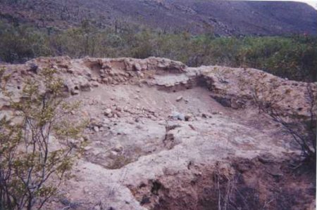
El Sauzalito copper mine town ruins, off to left of road: 30-05.89', 115-21.76'. Road turns north and goes 1.3 miles to:
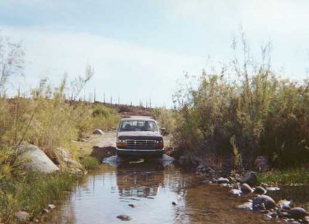
San Juan de Dios River Crossing: 30-06.83, 115-21.28'
0.2 mile from river is:
Fork, left is La Vibora road back to El Rosario, go right: 30-07.04', 115-21.33'
0.3 mile from La Vibora road fork is:
Fork, left is high country road to Los Martires, San Antonio, La Suerte or El Socorro/ San Quintin, go right: 30-07.22', 115-21.42'
Road goes straight north through boojum forest (not shown correctly in Almanac) 4.9 miles to:
Road turns from heading north to east. A road left goes down to a ranch: 30-11.11', 115-20.37'
From this ranch road to San Juan de Dios is 10.3 miles.
Second road to/ from ranch: 30-11.24', 115-19.89'
Fork, road right goes down to Cerro Blanco, continue east: 30-10.73', 115-15.55'
Major Fork! Left goes north 5.1 miles to El Sauce de Carter and beyond, go right: 30-10.98', 115-14.27'
0.7 mi beyond was a second fork (go left on newer graded roadbed). 3.1 miles more this newer road rejoined the older route and in 1.0 mile come to the
riverbed.
Road crosses San Juan de Dios River, note palms to left and road left to camping area in palms... continue to climb up from river crossing... at the
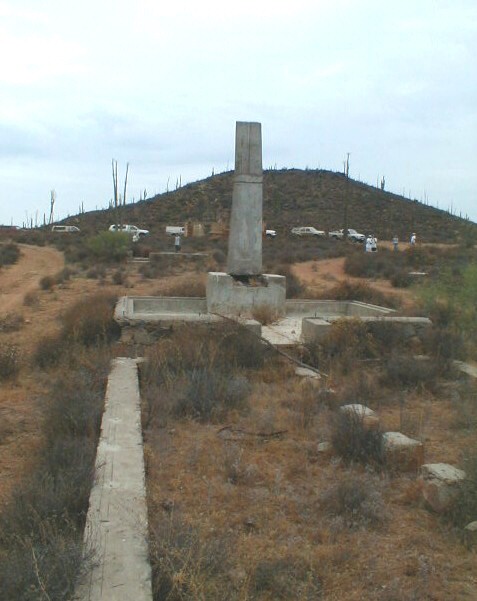
top of the climb, to the right of the road is (was?) the ruins of the Dominican mission visita of San Juan de Dios: 30-10.95', 115-10.03' elev.
1,838'.
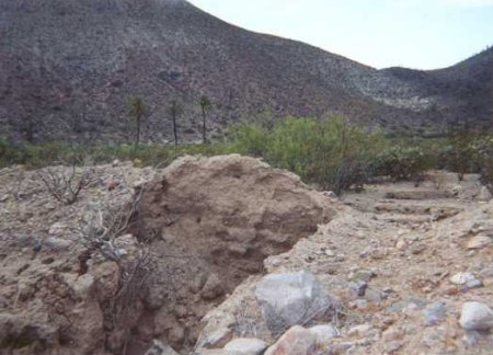
Road continues east... In 0.6 mile a fork turns left towards the riverbed and comes to some adobe ruins in 0.4 mile at 30-11.32', 115-09.14'. The
right (or straight ahead) road continues to Rancho El Metate, about 2 miles.
From ELINVESTI8: GPS at El Metate (map datum at factory setting of WGS84 and GPS in decimal degrees) 30.18483 degrees, 115.13769 degrees.
Converted to map datum NAD27 Mexico and more typical GPS in degrees and decimal minutes: 30-11.090', 115-08.261'
PHOTOS
Ditched airstrip 'El Arenoso' behind cafe Los Martires on Hwy. 1:

El Sauzalito ruins:
San Juan de Dios river crossing, near Sauzalito:
San Juan de Dios mission vista ruins, palms in background:
More of the Dominican visita for San Fernando mission:
The other adobe ruins, a mile from the visita:

[Edited on 12-24-2007 by David K]
[Edited on 12-24-2007 by David K]
Thank You David K
ELINVESTIG8R - 12-24-2007 at 11:45 AM
Here is Rancho El Metate or as I knew it "Rancho San Juan de Dios." Sany told me that a flood came down the river and wiped just about everything out.
The only thing left is the house and the water tank but it is in disrepair. Everything else I remember is gone such as the main house which would have
been on the left side of the tank and the ditches that brought in the water. Sany says he is rebuilding the ranch little by little. I love that Rancho
very much and it brings back a flood of good memories.
Sany told me that he and I went deer hunting on horseback. He had the 30-30 and I took the old Espinoza Mauser rifle. We split up and I ended up
spending the night in the mountains because I had waited to long to start back. Sany said the next day I returned but had forgotten the rifle up in
the hills. What a dummy I was. Well it was 1967 and I was 15 years old. When we went back to look for it we could not find it.
Forty years go by and Sany tells me that one week before I came down to El Rosario on December 15, 2007, someone he knows was out cutting wood and
found the rifle I lost all those years ago. When the poor guy came through the Army Check Point they hauled him to the Army Barracks in San Quintin
but released him with the rifle because it was rusted shut and inoperable. Sany says he now has the rifle and will be putting it in Mamas museum with
my name on it. Thanks dear brother Sany.

Mexitron - 12-24-2007 at 12:04 PM
Elinvest18--I've spent a few nights in that house back when it was generally abandoned in the 1990's except for occasional use by caballeros. I was
wondering if that was the adobe you were referring to on the other thread. My then girlfriend and I even considered asking Mama Espinoza if we could
stay there and fix it up. Alas, the girlfriend and I parted our ways before we could get anything going there. I love that country back in there--it
screams to my soul to get back!
The last time I saw it it looked like your picture--newly painted peachy color and a man growing some crops up by the small dam. Was that "Sany"?
Has the flood happened since 2004 when I last saw El Metate?
David K - 12-24-2007 at 12:50 PM
"Sany" (Sony) /Sergio born in 1947, looks just like his father, Heraclio.
ELINVESTIG8R - 12-24-2007 at 12:50 PM
Hi Mexitron, yes this is the place I was referring to in the other thread. This is the house I helped build 40 years ago. The main ranch house which
was located to the left of the water tank is no longer there. Mama gave the ranch to Sany and it since changed hands at least once, but Sany now has
it back and is fixing it up for his family. Regarding the flood I think it was the bad one that happened back in 1992 or 1993 when Mama Espinoza's
place was washed away.
[Edited on 12-24-2007 by ELINVESTI8]
Mexitron - 12-24-2007 at 12:59 PM
Thanks Elinvest18, I got it now--I never saw the main ranch house then because I didn't poke around in that particular area until 1993--so it was
already gone!
Lyly me and Sany
ELINVESTIG8R - 12-24-2007 at 01:03 PM
You are right David K. Sany is 5 years older than me. He was 20 and I was 15 back 40 years ago when I lived with Lyly and Sany at the ranch.
Here I am with Lyly and Sany about 2 miles northwest from the ranch. They were grading the road on the day I went to see them and found them and
others fixing one of the tracks that came off the Caterpillar.

Heraclio and Anita (Mama) Espinoza, 1970
David K - 12-24-2007 at 01:06 PM
The following from Mama Espinoza's autobiography 'Reflections' c1994:
Married Aug. 28, 1932.
10 Children:
Socorro 1933
Mario 1934
Lucio 1935
Maria del Rosario (Chichi) 1937
Eugenio 1939
Elva (Rolli) 1942
Heraclio (Pingo) 1944
Santiago (Jimy) 1945
Sergio (Sony) 1947
Antonio (Tony) 1949

ELINVESTIG8R - 12-24-2007 at 01:17 PM
 The very same man who yelled at me and would chase me out of Mama's kitchen
telling me"Get out of the kitchen and get outside and do mans work." Heraclio was a typical Mexican Macho man but he was a good person. I remember
him always outside and whistling.
The very same man who yelled at me and would chase me out of Mama's kitchen
telling me"Get out of the kitchen and get outside and do mans work." Heraclio was a typical Mexican Macho man but he was a good person. I remember
him always outside and whistling.
David K - 12-24-2007 at 01:36 PM
Really great stuff David... Thank you so much for taking the time to share it here!!! Merry Christmas!!!
Here is your GPS for El Metate and converted to the way GPS is usually posted on Nomad (this was also added to the opening post/ road log):
From ELINVESTI8: GPS at El Metate (map datum at factory setting of WGS84 and GPS in decimal degrees) 30.18483 degrees, 115.13769 degrees.
Converted to map datum NAD27 Mexico and more typical GPS in degrees and decimal minutes: 30-11.090', 115-08.261'
ELINVESTIG8R - 12-24-2007 at 03:14 PM
Thanks David K. You have a wonderful and Merry Christmas too!!! I also wish a Merry Christmas to all the rest of the Baja Nomads too. Have a wonderful
time.
David K - 4-30-2009 at 09:23 PM
Some interesting stuff in here, perhaps?
BajaBruno - 4-30-2009 at 09:39 PM
Not to ruin the flow here, but just a note on map coordinates. Coordinates taken off of most maps (which predate the GPS era), for those who know how
to take coordinates off of maps, do not necessarily align with GPS units and may be +/- one mile off.
GPS is very precise and map-making was done with crude survey equipment and sextants, depending on the source. If you are following a map coordinate
on your GPS, be flexible and compare the actual surrounding area with a good topographical map to locate your target.
If you are following someone else's actual GPS plot, then you should be able to get much closer to your target.
David K - 5-1-2009 at 08:50 AM
Great... do you have an example, or an application to illustrate your comment?
Many of us use the Baja Almanac (book form of the Mexican topo maps) which is drawn to map datum NAD27... and the GPS is factory set at map datum
WGS84, and is easily changed so the points on the map and GPS match.
The difference in the two is perhaps only a few feet to a few hundred feet, but it may mean missing a road fork to take?
Topo maps do help one see the terrain. Also, Google Earth is a good way to see the area before your trip. Google Earth is at map datum WGS84.
BajaBruno - 5-1-2009 at 09:57 AM
David, I am certainly not an expert on this subject, but my experience from using nautical charts has been that the error between a chart position in
Baja and a true (satellite) position is up to one mile.
I have spoken to NOAA people about this and their explanation is that it is impossible to correct the charts without re-surveying the entire region.
For example, by moving a shoreline to the actual location, the map-maker is required to stretch or compress (depending on the direction of
adjustment) the land and subterranean features that abut the moved shoreline. No one has the will to do this in Baja or the rest of Mexico.
The Washington Meridian, on which US surveys were based, has been found to be up to 2.5 miles off of the Prime Meridian, which accounts for the
recent news articles that the Four Corners monument is in the wrong place. It is not in the wrong place legally, because US law recognizes the
error and fixes state boundaries based on the old (incorrect) datum, but the monument is not in the place specified by a simple lat/lon calculation of
the historical fix.
As the USGS has updated maps from NAD 27 to NAD 83, corrections have been made and these corrections are indicated by dashed crosses near the corners
of the map, which USGS writes, means that adjacent quadrangles on different datums will not join exactly. A good reference starting point is: http://geology.er.usgs.gov/eespteam/GISLab/Cyprus/datums.htm
The USGS uses equations to convert maps from one datum to another, but they confess that these are merely estimates and some features will be more
accurately rendered than others. The difference between NAD 27 and NAD 83 can vary considerably and not necessarily predictably, and charts and maps
from various sources (even the government) can be based on surveys from many different eras which varying accuracy.
For example, if a point is based on a survey of, say, 1913, which is very common even in US charts, the location of the feature may have been
inaccurately fixed by any datum. No amount of algorithmic torturing is going to make that fix more accurateonly a live chart-maker using more
accurate information can correct the chart and the USGS has precious few resources for such a time-intensive endeavor for even US maps, much less
Mexican ones.
My message here after all this gobble-d-gook is simply than the maps and charts are fallible and some good map reading/interpreting skills are
valuable if one is looking for a precise location.
David K - 5-1-2009 at 04:35 PM
Well, you do very much sound like an expert and I am happy that you are providing this information! I wanted to be a cartographer, but ended up in
irrigation as a profession and just draw maps as a hobby!
Certainly nautical chart precision is a lot more important than land maps... no hidded reefs to take out our oil pans, so-to-speak!
I am looking forward to the 2009 Baja Almanac and to search for errors (just for fun)!
BajaBruno - 5-1-2009 at 08:55 PM
When I was checking boundary lines for the federal gov't, I rarely used the potential of the maps, even though I had maps with margin marks that would
allow me to plot a fix. I just found a survey monument, estimated distance with the edge of my pencil set against the latitude ticks, and used a
magnetic compass to follow a rough azimuth to the next monument. Nautical navigation needs to be more precise and I took the time to do it right when
working with charts.
Few non-goverment maps have the margin marks to plot a fix with any precision (unfortunately, I don't have a copy of the Baja Almanac so I don't know
what it looks like), but few people know how to plot a fix if they wanted to, and even fewer people have any need to do so.
Most people today follow someone else's GPS fix. My GPS will follow to your GPS's fix within a very tolerable error level and where the map places us
is really of little interest. If we are really fussy, we could triangulate a fix from a few prominent landmarks for a rough field fix, so we can put
an "X" on the map to show that Kilroy was here,
but, as long as the batteries of your GPS hold out, maps seem to be becoming an artifact of a bygone era.....much as I still love them....
TMW - 5-2-2009 at 10:40 AM
BajaBruno's point is well taken. In the news the other day they said the location where the four states come together, AZ, NM, CO and UT, at Four
Corners is a mile or more off, I think to the east. I don't remember the exact distance or direction.
TMW - 5-2-2009 at 10:42 AM
Modern techniques of geodetic survey and measurement are being used to nitpick the work of a surveyor in the 19th century, a time before Garmins and
Google Earth. The report in Utahs Deseret News, is that Americas most famous sprawl slab, is approximately 2.5 miles west of where it should be.
Subsequent stories put the discrepancy at as little as 1,800 feet and this argument has been going on for over a century among the maparati.
Utah, Colorado, Arizona, and especially New Mexico which has the access road to the monument neednt get worked up about this. The monument is, in
fact, exactly where it should be: on the spot where the four states meet. That spot, however, is in the wrong place.
In other words, this is a problem for survey purists, not for tourists who want the geographic thrill of standing in four states at one time. This can
still be done, right where the monument is now. To fix the error, someone would have to move legally codified borders, not merely the monument and
thats not going to happen.