I recently received an email from Baja Nomad member 'Kevin in Oklahoma' who is one of the contributors to my Baja Missions web page photo collection.
http://vivabaja.com/bajamissions
I believe Kevin whould like me to share it with you, specially those of us who think the historic sites should be recognized and preserved for the
future history buffs.
San Juan de Dios is where Junipero Serra had to stop his walk to San Diego from a painful leg infection that was cured by one of the muleteers using a
poultice treatment for the mules. Later, San Juan de Dios became the site for a mission visiting station (visita) for California's first Franciscan
mission, San Fernando Velicata... which was the first mission founded by Serra (not San Diego, as California history books teach).
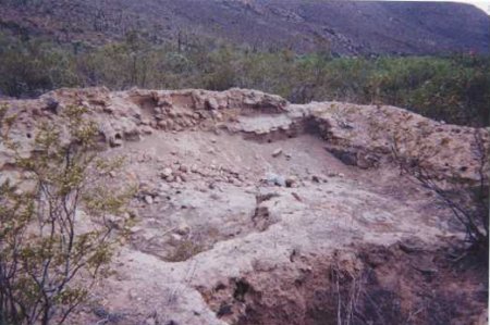
Here are the ruins of the visita:
A few months ago, Neal Johns and John M went to San Juan de Dios for the first time and couldn't find the ruins, just plowed fields... Hoping they
were in the wrong place, I planned on going back to confirm the bad news.
This letter from Kevin seems to indeed spell it out... Why we want all Nomads and Baja history fans to know where the sites are and to visit them...
to show that they DO have value and a reason to save them!
Here's Kevin's letter of 1-20-08:
Hi David,
It's been a long time since we touched base. I just got back from a few weeks in Baja and will be heading back in a few more.
First, My wife and I spent a couple days up and around the San Juan de Dios area in late December and unfortunately need to report the the San Juan de
Dios ruins have been dozed over and a small rancho set up by the palm trees. As we were in the area we found the dozer operator, who is keeping the
road open to the rock mines, and asked his wife if they also dozed the site - answer was yes, for the ranch. (We must always remember it is not our
country and they must have needed the land cleared and I do not think they had any idea about what the site was) - Nothing remains.
Second, we hiked up to the site that Jack had been to years before and all of those ruins remain, a very large rancho with many adobe structures, a
well, corrals, and a small rock-fenced cemetary. I tried to date the ranch by the remaining artifacts but could not find any old pottery pieces but
did lots of old glass (purpled), hard to tell if it dates to the former visita days but if not it was set up not much later. (Lots of water and level
tillable fields).
Also, for all those folks with new 2007 ULSD vehicles, we had two new 2007 Dodge's and drove them to Cabo (close) and back without any fuel issues at
all. The price of diesel fuel is great.
Take care
Kevin in Oklahoma
[Edited on 1-23-2008 by David K]
Map
David K - 1-22-2008 at 04:22 PM
My sketch map of the area
David K - 1-22-2008 at 04:23 PM
Another
David K - 1-22-2008 at 06:49 PM
Jack Swords - 1-22-2008 at 07:08 PM
Sad...that's why the photographic efforts need to continue. Thanks for the update.pappy - 1-22-2008 at 09:47 PM
isn't that a protected area?MexicoTed - 1-22-2008 at 10:46 PM
Oh that makes me sick to hear that David and Kevin. I just forwarded the information to the Secretary of Tourism. In our meetings, I try to convey the
importance of these historical sites to the, no matter how offroad, etc.
DK, you are correct in stating that we all need to visit these sites to show the tourism people that they are important. I have thought about this
before, but I am now going to put this into action. I want to get a petition with signatures stating that we (the tourists and ex-pats) would like to
see more done to protect these priceless historical sites. More on this soon.
Also, Kevin is correct in stating that we are visitors here and people need to do what they do to survive. Educating them may help.
TedDavid K - 1-23-2008 at 08:16 AM
Thanks so much Ted!
Jack Swords photos of San Juan de Dios talen 11-12-03
David K - 1-23-2008 at 08:20 AM
#1 of 4
[Edited on 1-23-2008 by David K]
David K - 1-23-2008 at 08:21 AM
#2 of 4
David K - 1-23-2008 at 08:22 AM
#3 of 4
David K - 1-23-2008 at 08:23 AM
#4 of 4
Photos I took in July, 2000
David K - 1-23-2008 at 08:27 AM
ElFaro - 1-23-2008 at 08:54 AM
"(We must always remember it is not our country and they must have needed the land cleared and I do not think they had any idea about what the site
was) - Nothing remains. "
"I do not think they had any idea about what the site was" - this from a gringo from Oklahoma...how do you know what the owners know or don't know
about the site ??
Do you speak fluent Spanish and did you spend time with the owners to find out why they plowed under the land ? They may have plowed it up because a
land dispute got resolved and someone may have had bad memories of the place in the distant past and wanted to "start over". It could be for a reason
you have not even thought about and the owners are not going to tell you directly. Remember its not cheap to use a bulldozer out in the middle of
nowhere to plow up fields and then have them sit idle.David K - 1-23-2008 at 09:28 AM
El Faro, the answer from my visit is yes... The 'owner' is Sony Espinoza (one of Mama Espinoza's sons). He showed me the site in 2000 as it was not
visible from the road... hidden by brush, just a few feet from the road.
The land out there is huge... that a 100' X 25' plot couldn't be saved as a link to the 1700's is sad. INAH has the site recorded and plotted, but
never bothered to erect a sign or fence around it.... To me, that indicates it had to them no value to preserve... and that is sad too, because that
is what INAH is supposed to do. Perhaps they thought the site so remote that they didn't need to worry about protecting it?
I do not know if it was Sony who plowed it over, maybe Kevin knows. As far as where Kevin is from, I don't know why that matters if he has a deep love
for California history and has been to all of the Baja mission sites. As I said before, he is one of the contributors to my Baja Missions web page. He
has visited sites by ATV and foot as well... If you do a search, you will read about his ATV trip from San Quintin to San Isidoro. He has also hiked
from near Vizcaino to the visita of San Pablo (often believed to be the mission of Dolores del Norte).
Maybe ELINVESTI8 (David) will learn next time he visits Sony?BAJACAT - 1-23-2008 at 08:12 PM
Sad event David,to bad it's gone.We can do so little,to help prevent this.just
remember San Maria mission project,Inah wasn't interest it, in let private hands fix their problems.And still didn't do anything to fix it...David K - 1-23-2008 at 08:27 PM
Quote:
Originally posted by BAJACAT
Sad event David,to bad it's gone.We can do so little,to help prevent this.just
remember San Maria mission project,Inah wasn't interest it, in let private hands fix their problems.And still didn't do anything to fix it...
The funny part about the Santa Maria drainage project was that INAH was in favor of our idea... I even bought the materials the day before we were to
leave. An email that evening from the very same INAH person said NO, we couldn't do the work and asked us to bring one of their people in who was
driving down Hwy. 1 that day to see the site, and return him back to Cataviña that SAME day!
It is 3 hours one way, and we were going to be camping there, naturally... So, they wanted me to make room for this person, then bring him back out,
then I would need to drive back in... 9 hours driving from about noon plus his time looking that day!
Then last year they made a big deal that resoration was under way... took lots of photos... and last MAY when I went back.... NOTHING was done!
Here's a photo of the doorway erosion we proposed to halt by installing a drain inside the mission and run the pipe out through the doorway, build up
the soil so rain water would no longer run out through the doorway, but through the drain instead.
BAJACAT - 1-23-2008 at 08:32 PM
It's going to be a shame to see those walls colapse,I need to look for my cutoff saw and start choping my truck in half,just so i can make it to
SMDLA, mission lolDavid K - 1-24-2008 at 09:39 AM
Here's another shot of the eroding doorway at the 239 year old wall...
David K - 1-24-2008 at 09:44 AM
Looking in from outside...
San Juan de Dios: Visita's GPS waypoint
David K - 1-24-2008 at 02:05 PM
Your GPS comes set to the map datum of WGS84 at the factory, but the topo maps of Baja are drawn to the datum NAD27 (which is changed in the 'set up'
programing of a GPS).
Map datum WGS84: 30°10.960'/ 115°10.074'.
Map datum NAD27 Mexico: 30-10.952'/ 115-10.033'.
elevation: 1,838'
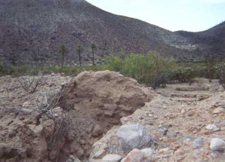
The ruins were on the right/ south side of the road to Rancho El Metate, just past the road to the left into the palm grove, at the top of the small
climb... It was less than 50 ' from the road (maybe 20') and the rooms ran about 90 feet long to the south from the road in a long rectangle, with one
larger side room in the middle... see the photos above.
ELINVESTIG8R - 4-26-2008 at 04:15 PM
Hi David K. From 4/12/2008 through 4/19/2008, I went to El Rosario to visit with Mama Espinoza. I also went to Rancho El Metate. On the way I stopped
off at Rancho Las Palmas to look into the rumor that the mission was plowed over. Well I am here to tell you that it is unfortunately true. I then
spoke to some of the people who are part of the Ejido in the area as well as the head man of the Ejido to find out anything I could. Of course all
denied knowing anything.
Running spring behind the three palm trees.
Grave just a few steps west of the old mission site.
Cactus at foot of grave.
Two graves of two sisters married to Espinoza men in the 1900s. The sisters died during childbirth. Their children are buried next to them. This is
just south of the Las Palmas Ranch.
The two children of the two sisters.
Adobe Ruins just east of the grave site.
Lime oven south west of the grave site.
Here is the Mujer Dormida (Sleeping Lady) Mountain on way to Rancho El Metate San Juan De Dios.
Here is an Indian rock drawing of what appears to be a hummingbird from the spot I took the picture of the Sleeping Lady Mountain.
[Edited on 4-28-2008 by ELINVESTI8]David K - 4-27-2008 at 10:20 AM
Thank you David (ELINVESTI8) so very much...Mexitron - 4-27-2008 at 11:41 AM
Thanks Elinvest--nice to see that area again, man I miss it! Did you also explore over to Rancho Cartier by the river?Sharksbaja - 4-27-2008 at 12:05 PM
Hey what happened to the pics from Elinvest18?David K - 4-27-2008 at 05:56 PM
They are still there... re-boot Nomad and look again!ELINVESTIG8R - 4-27-2008 at 06:04 PM
Quote:
Originally posted by Mexitron
Thanks Elinvest--nice to see that area again, man I miss it! Did you also explore over to Rancho Cartier by the river?
Hi Mexitron, I am sorry to say that I did not make it there. I only went to El Metate and back to El Rosario. I brought my guitar and looked for the
Mexican Soldiers on the back roads so I could sing them Mexico Lindo as I had done back in December 2007, but alas they were not present.Sharksbaja - 4-27-2008 at 06:47 PM
Good job on locating the place. Is there standing water?
What a drag that sites are not all marked and otherwise protected.
Dk, I think it must have been my temp filed. Once deleted no mas problemo.ELINVESTIG8R - 4-27-2008 at 07:03 PM
Quote:
Originally posted by Sharksbaja
Good job on locating the place. Is there standing water?
What a drag that sites are not all marked and otherwise protected.
Dk, I think it must have been my temp filed. Once deleted no mas problemo.
Sharks I really did not explore much around the spring so I could not tell you if there is any standing water. I just had a drink from the running
spring and I can tell you it is some of the sweetest water I have ever drunk.


 .We can do so little,to help prevent this.just
remember San Maria mission project,Inah wasn't interest it, in let private hands fix their problems.And still didn't do anything to fix it...
.We can do so little,to help prevent this.just
remember San Maria mission project,Inah wasn't interest it, in let private hands fix their problems.And still didn't do anything to fix it...


