BajaNomad

Rancho/Casa La Concepcion

astrobaja - 8-10-2008 at 06:20 PM

Hi all,

Well its been about 4 months living here at rancho concepcion (near San Pedro Martir park) and we've done a LOT of cleaning up of garbage, old fences, and old farm implements. Some replanting of flowers, cacti, and 18 new table grapes which will create a living fence along the road that leads to Mikes Sky ranch. Its pretty secluded here sometimes we only get 2 cars (or more likely dirtbikes) all week! But it is fabulously beautiful, and once we get up and running with our B&B we will have a good flow of people so my Wife and I don't drive one another too nuts!
Our house has its vigas going in and we should have a roof in another month. The white appearance now is because of the lime/arroyo sand plaster. one last coat will go on with an ochre pigment, should look quite nice. The other pic is of the original small adobe casa which will be restored and can be the 1st guest cabin.

view.jpg - 49kB

astrobaja - 8-10-2008 at 06:23 PM

view of the house

view2.jpg - 46kB

astrobaja - 8-10-2008 at 06:25 PM

another view

view3.jpg - 44kB

astrobaja - 8-10-2008 at 06:26 PM

apple orchard and the old adobe cabin

oldadobecasa2.jpg - 48kB

astrobaja - 8-10-2008 at 06:28 PM

heres our trailer where we now live right beside a magnificent 700 year old oak! The nearby arroyo canyon has 100's of old oaks, its like walking amongst the Ents of Lord of the Rings!

oldoak.jpg - 46kB

Bajaboy - 8-10-2008 at 06:31 PM

Awesome! Can't wait to get up that way again soon.

Zac

Cypress - 8-10-2008 at 07:07 PM

astrobaja, Thanks for the pictures. Good luck with your adventure.:D

Udo - 8-10-2008 at 07:08 PM

NICE FJ!

thebajarunner - 8-10-2008 at 07:38 PM

Forgive me for being dense...

but where, exactly, are you?

I have been up to the park several times recently,
can you give some clue as to location....

like miles past Meling, or something tangible.

astrobaja - 8-10-2008 at 08:02 PM

Bajarunner:

Ok so Meling is at km 50, the turnoff for our road is at km 67 about 12 km from the park entrance. Theres a sign (very worn and almost illegible) for Rancho La Jolla and we are 6km in that road. Our road becomes quite bad (4wd only) after our property and Mikes Sky ranch is a one hour drive away.

astrobaja - 8-10-2008 at 08:08 PM

Good eyes Udo;D

Our FJ is a super vehicle for Baja! Ours has a stage 2 suspension kit from Demello Racing and a winch which has come in very handy in numerous occasions!
Heres a pic of our road this spring before it was fixed up...it is a fair bit better now!

roughbit.jpg - 44kB

thebajarunner - 8-10-2008 at 08:21 PM

Thanks, know right where you are,
and yeah, the road ascends quite precipitously after Meling

David K - 8-10-2008 at 08:50 PM

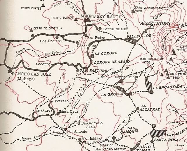
The only map I could find tonight that has Rancho Concepcion on it is this one by Walt Wheelock of La Siesta Press in John Robinson's: 'Camping and Climbing in Baja' c1967


Note it is east of Los Encinos which was the original site of Mike's airport (late 60's early 70's)... This map from the 1983 book edition incorrectly locates Mike's Sky Rancho too far upstream... It is really closer to the 'R' in Rafael (in Arroyo San Rafael).

In the Baja Almanac, Rancho Concepcion would be on Map 11, U3... about where the road east of Los Encinos crosses the arroyo... astrobaja can correct me, naturally... I am just estimating.

The new road coming north from the observatory highway to Concepcion is not shown... only the old route from Los Encinos, east of El Coyote.

[Edited on 9-28-2010 by David K]

BajaWarrior - 8-10-2008 at 08:54 PM

Congradulations on your work so far, that looks like a very solid casa.

Diver - 8-10-2008 at 08:56 PM

Good luck with your dream.
It looks like a beautiful place !

capt. mike - 8-11-2008 at 06:16 AM

that's your road in??!!
how do you get building materials in there???
amazing stuff.

let us know when you have carved in an airstrip.:light:

David K - 8-11-2008 at 08:49 AM

In the good old days, airstrips where everywhere in Baja (because to drive there often took many days)! Now, with the drug running most of those runways have been ditched and the few left open must pay a high fee to the government every year.

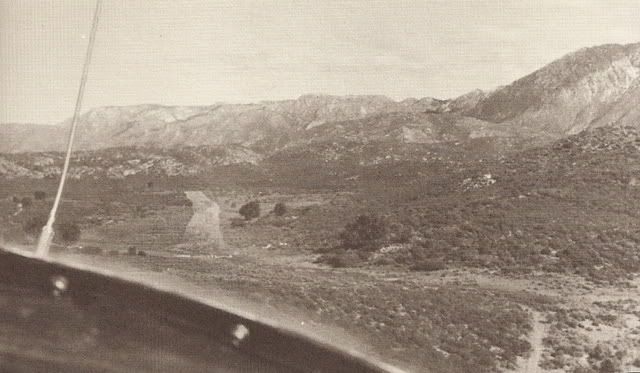
The closest airstrip that is open would be the Meling Ranch (Rancho San Jose). The closest abandoned runway would be Los Encinos (the original Mike's Sky Rancho airport)... which did have a curve in it!

Here's a photo of the Los Encinos/ Mike's old runway from Marvin Patchen's 1981 'Baja Adventures by Land-Air-Sea' ...


[Edited on 8-11-2008 by David K]

capt. mike - 8-11-2008 at 10:08 AM

that's not a curve, it's a high speed taxi exit.

astrobaja - 8-11-2008 at 12:47 PM

David: cool old maps and pics! Yeah that old runway was supposed to have been demolished by the army cause it was being used by "avid horticulturalists". You can still see its outline on google-earth!

Capt Mike: yeah that was the worst of the road, its passable in 2wd now.
It still is a challange getting building supplies in! We use a small trailer.
The construction crew come via Mikes which is very rough cada semana!!
I doubt you'd get any Canuck or Yank crew to do that!

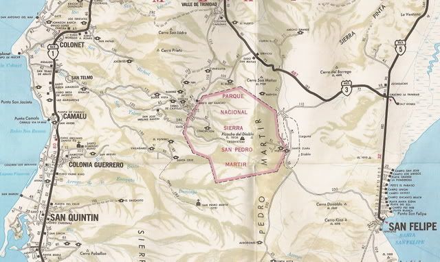
Concepcion on 1978 Auto Club map!

David K - 8-12-2008 at 09:25 AM

30 years ago, the auto club shows the road going right past the Los Encinos airstrip and ending at Rancho Concepcion!


[Edited on 9-28-2010 by David K]

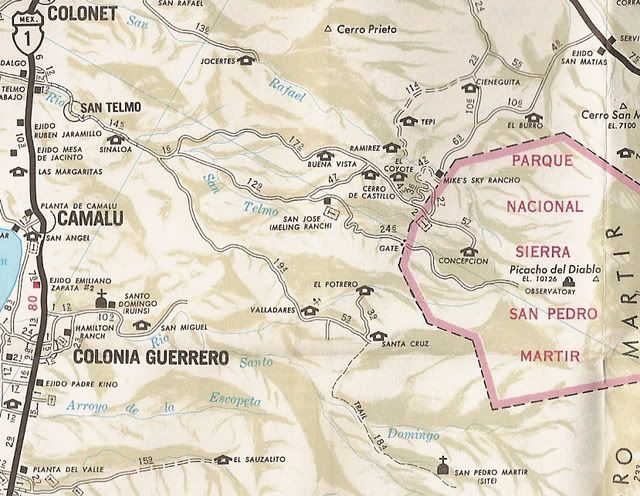
David K - 8-12-2008 at 07:45 PM

Close up from another map, area above/ near Concepcion... Concepcion is at or near where that center dirt road crosses the arroyo. In this map (unlike the AAA map) you can see that Concepcion's location is not inside the park.

[Edited on 8-13-2008 by David K]

corral de sam-r.JPG - 48kB

fdt - 8-13-2008 at 07:40 AM

Congratulations, it's looking great. Hope to go there soon.
Saludos

DirkEXC - 8-13-2008 at 09:54 AM

Hello AstroBaja,

I was wondering if you will cater to the offroad people. I am all for responsible use of the trails and I would enjoy a new place to ride to for dinner, bed and a shower. Thanks Dirk

wilderone - 8-14-2008 at 08:56 AM

Do tell - how did you happen to learn about the property and buy (lease?), or what? When do you think you'll be finished with the structure? Do you work on it all year? Where do you live in the meantime? Very intriguing photos. thanks

baitcast - 8-14-2008 at 09:59 AM

Astro what is the altitude? no light pollution there! how is the viewing?........Looks like the hot set-up.congrats
Rob

astrobaja - 8-14-2008 at 03:04 PM

Hi all, we've been in San Diego for a couple days sorry not to reply sooner!

Baitcast: our land is 1200 acres, but where I plan on building my observatory (a 30X40 slide off roof type) its around 4850'.
Its about as dark as you can get, a lot depends on dust in the air, water vapor etc, collectively its described as transparency to astronomers. There is a website used by professionals and amateurs alike it forecasts transpanreny, cloud cover and seeing (how stable the air is). Heres the link to mine:
http://cleardarksky.com/c/EqlsSObMXkey.html?1

If you click on sky darkness it shows a map of light pollution, it shows a totally black class sky!

come and visit!

Mike

[Edited on 8-14-2008 by astrobaja]

astrobaja - 8-14-2008 at 03:10 PM

Wilderone: We learned about the place by staying at Meling and talking to David Lang, he was just starting to consider putting the ranch on the market so we were just plain lucky there!
We bought the property through the formation of a Mexican company.
We're living here as the place is being built, just a little travel trailer is all we need, hope to have the house/observatory/office buiding done by dec/jan.

astrobaja - 8-14-2008 at 03:15 PM

Hi Dirk,

We've had a few tours both bike and car come through and have chatted with the tour leaders. We told them we would eventually have a spot with hot showers and a bunkhouse to crash for the night.
Our main thrust is to cater to amateur astronomers, birders, and people interested in experiencing nature but don't mind the occasion tour coming through.

We have however told Sal Fish that he will have to find an alternate route (probably through Rancho Coyote) for the Baja 500/1000 its just gonig to be too much disruption for our road/sanity. But theres lots of other routes for them to use, besides our road is too boring for them now!

astrobaja - 8-14-2008 at 03:21 PM

David: cool maps! Yes I think our ranch runs very close to the edge of the park roughly in a line with the west ridge. We are working with the federal gov't to get our property classed as a conservation area. This will get us help with fencing to keep out unwanted cattle, which destroy oak woodlands. It will be a BIG job but worth it in the end.

David K - 9-28-2010 at 03:08 PM

Reloaded maps that went missing... done!

mcfez - 9-28-2010 at 09:29 PM

astrobaja.....any updates on the finished project here?

You got guts!

David K - 9-28-2010 at 09:32 PM

Check out his web site http://www.bajadarkskies.com

mcfez - 9-28-2010 at 10:43 PM

Quote:
Originally posted by David K
Check out his web site http://www.bajadarkskies.com


Oh! Yeah...! I was there last week (web) accidentally. I think he got a great set up. Want to take my young man there someday.

Thanks again DavidK for the continuously Baja data that is very helpful. May the Dripline Gods be good to you :spingrin:

David K - 9-29-2010 at 07:11 AM

Quote:
Originally posted by mcfez
Quote:
Originally posted by David K
Check out his web site http://www.bajadarkskies.com


Oh! Yeah...! I was there last week (web) accidentally. I think he got a great set up. Want to take my young man there someday.

Thanks again DavidK for the continuously Baja data that is very helpful. May the Dripline Gods be good to you :spingrin:


Many thanks!!! Yes, let's hope for the gods of Netafim and MP Rotator shine my way!