David K - 11-14-2008 at 11:24 AM
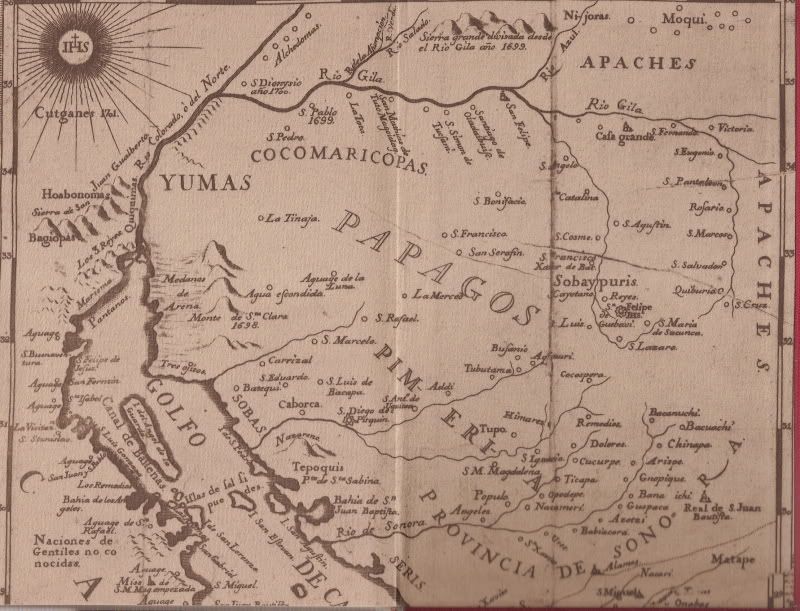
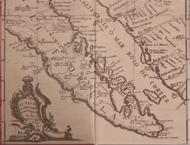
This is the famous map that caused many to believe that lost missions did exist in Baja!
The map reflects the status of missions sometime between 1746 and 1749 per the description of Dolores del Norte (Santa Gertrudis) mission project of
being 'started' ("empezada"). Also, the La Paz mission as shown was closed in 1749, moved to Todos Santos, and renamed 'Pilar'. The 1746 volcanic
eruption of Tres Virgenes is shown on the map.
Now some authors and map makers have since seen the Dolores del Norte on this map and did not know that was just an early name for Santa Gertrudis and
made it a unique mission northwest of San Ignacio... The villagers at San Francisco de la Sierra told Choral Pepper in the early 1960's that the old
rock walls in their village were the ruins of 'Dolores'. Perhaps the Spanish soldiers who stayed after the padres left handed down that story because
it may have been an early choice for the Dolores mission?
However, two more missions are shown as 'started' but have never been documented by the Franciscans who took over mission operations in 1768. They are
San Juan Bautista, west of San Ignacio and Santa Maria Magdalena south of Bahia de los Angeles.
San Juan Bautista is also known as the lost Santa Clara mission, in the Santa Clara mountains north of Punta Abreojos where the Jesuits hid their
possesions of gold and silver altar pieces or more when they received advance warning of their expulsion from the New World. Another legend is of a
mission called Santa Isabel believed to be near Mision Santa Maria or further north. Near today's Puertecitos is a waterhole called Santa Isabel on
this map.
Santa Maria Magdalena may have been discovered in 1966 by the Erle Stanley Gardner expedition as a site of walls, dam, watch tower ruins some miles
south of Bahia de los Angeles. It is this site I have been trying to 're-find'... See http://vivabaja.com/1757


[Edited on 11-14-2008 by David K]
David K - 11-14-2008 at 11:50 AM
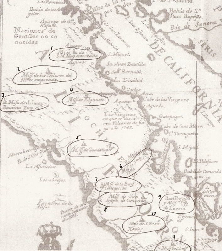
If you need some help locating the sites, here is a light copy and the missions are circled:

1: S.M.Magdalena 'started'
2: Dolores del Norte 'started'
3: S. Juan Bautista 'started'
4: S. Ignacio
5: Guadalupe
6: Santa Rosalia (de Mulege)
7: La Purisima Concepcion
8: San Jose de Comondu
9: Royal Precidio and Mission of Loreto
10: San Francisco Javier (Xavier)
11: San Luis Gonzaga...
off this copy, but on the map as you go south are:
Dolores del Sur, La Paz (abandoned at the bay in 1749), Santiago de las Coras, Santa Rosa (Todos Santos, but shown on the opposite side of the
peninsula),
and San Jose del Cabo.
redmesa - 11-15-2008 at 07:07 AM
Politics and religion aside, I am always in awe of the determination and resourcefulness of those first Jesuits throughout the California and Baja
California. Thanks for the impressive map and the reminder of times past (where so many mysteries lie).
David K - 11-15-2008 at 07:52 AM
De nada... they are a great look into the past!
David K - 5-12-2009 at 04:13 PM
Russ, the mission circled on the light copy #3, is the lost Santa Clara mission north of Punta Abreojos... Still lost!
David K - 7-8-2009 at 07:57 PM
We may have photographed #1 (Santa Maria Magdalena) last January... Originally found in 1966... http://vivabaja.com/109
But, still no photos of the Lost Santa Clara Mission, San Juan Bautista (#3) near Punta Abreojos...
Anyone???


