BajaNomad

LOUSY ROAD-- ENSENADA TO TECATE

DENNIS - 2-11-2009 at 07:57 PM

It's terrible and I've had it. This is my normal way of passage when going to the states and it used to be well kept and comfy.
No more. The road is being widened, which is good but, it's five miles of dirt and bad road coming from Ensenada before you meet the hard surface which has been upkeep denied for the remaining trip to Tecate. It's a stressful trip for a driver for having to concentrate on the surface of the road. Some of the pot-holes will ruin your day.

My choice will be to go north on the toll road and go up Blvd. 2000 to the Tecate toll road and go over on that. I havn't clocked it as yet but, I'm told it adds eight miles to the trip. Not a bad price to pay for keeping the front end in your car in one piece.

Von - 2-11-2009 at 08:01 PM

The road wasnt that long of a fix couple weeks ago when i road my moto down there? probably a mile or two of patches no?

Bad road

BajaDanD - 2-11-2009 at 08:06 PM

We are heading down next week through Tecate across to Ensenada then down. Now Im thinkin maybe we'll go all the way over to TJ and take the toll road.
What would you do?

woody with a view - 2-11-2009 at 08:07 PM

i'd just go!;D

Bob H - 2-11-2009 at 08:09 PM

We took that route Jan 25th or so, going to Ensenada Northbound, and it was horrible, especially in a motor home or cab over camper like we have.
The first five mile are very dangerous and very time consuming indeed.

See my original thread on this same subject.

http://forums.bajanomad.com/viewthread.php?tid=36628#pid3869...

Bob H

[Edited on 2-12-2009 by Bob H]

DENNIS - 2-11-2009 at 08:10 PM

Quote:
Originally posted by Von
The road wasnt that long of a fix couple weeks ago when i road my moto down there? probably a mile or two of patches no?


No. I don't know what you saw, Von but, there is no asphalt[today just mud] for about five miles from just north of Sauzal and the hill taking you over to San Antonio.
Being on a bike, I would assume the surface imperfections would be less of an issue for you with your maneuverability. It's harder for a car.
I stand by my evaluation.

Pescador - 2-11-2009 at 08:21 PM

As long as it keeps me out of Tijuana and a two or more hour crossing, I will take it even if I have to use 4 wheel drive and I shake the dishes out of my Lance Camper. It was pretty good when we came down two weeks ago, but they sure were busy on the road. Maybe because it was Sunday made a difference.
Se did take the toll road from San Luis up over the Rumarosa Grade and it was nothing short of magnificent. I think I will have to do this again.

DENNIS - 2-11-2009 at 09:12 PM

Quote:
Originally posted by Pescador
As long as it keeps me out of Tijuana and a two or more hour crossing,


Well, I told you how you can get around it without getting near TJ when going north.

Timo1 - 2-11-2009 at 09:13 PM

no problem in our 34 foot moho.....that was 3 weeks ago

osoflojo - 2-11-2009 at 11:25 PM

"The driver has to concentrate on the road surface".................sound like any trip up or down I have taken in the last 20 years!!

Bajahowodd - 2-11-2009 at 11:45 PM

Actually, BLVD 2000 goes through Tijuana. Just Not near downtown. the bad news is that the Narco nasties are considered to to hang in East TJ.

DENNIS - 2-12-2009 at 08:20 AM

Quote:
Originally posted by osoflojo
"The driver has to concentrate on the road surface".................sound like any trip up or down I have taken in the last 20 years!!


I know it's always like this but, for the road mentioned, it's become worse. There is planned expansion of the road, it's happening now. It seems that regular maintenance has been put on hold pending the new, wider road.
It's just that it ain't what it used to be.
I don't care who drives it. Means nothing to me if somebody wants to tear hell out of their vehicle, especially when there is a better option. I just thought folks would like a road report and an opinion, even mine.

tripledigitken - 2-12-2009 at 08:55 AM

Dennis,

Going north on the Toll Road which exit would we take to get to Blvd 2000? Your report has me second guessing our return route next month in the camper!

Thanks,

Ken

David K - 2-12-2009 at 09:23 AM

Quote:
Originally posted by tripledigitken
Dennis,

Going north on the Toll Road which exit would we take to get to Blvd 2000? Your report has me second guessing our return route next month in the camper!

Thanks,

Ken


Ken, just to answer this while Dennis is busy: Puerto Nuevo exit... to free road then north about 6-7 miles. The free road is now 4 lanes wide to about this point. Just when you see the Foxploration studio complex at Popotla, the Blvd. 2000 highway meets the free road (signal)... Also signed BC 201... or was.

Here is my road log from May, 2007:

MEXICO at Otay Border: Mile 0.0, Time 0:0

Head straight south, staying in left lanes. Follow signs for TECATE.

LEFT TURN at signal, slight curve to left just before signal: Mile 1.1, Time 0:03

Heading east on Blvd. Industrial... soon becomes divided highway!

Take new highway south, signed for Rosarito, Popotla, Ensenada (toll highway 2-D to Tecate curves to left, see toll gate, Big Horn Sheep monument almost unseen heading south): Mile 6.0, Time 0:13

Free Hwy. 2 (TECATE) interchange, continue south then southwest: Mile 13.0, Time 0:22

Cross the Rodriguez/ Tijuana reservoir and head into the hills...

Pass under the toll highway (Mex. 1-D) and come to the free highway (Mex. 1)... Mile 31.3, Time 0:38.

They will have it connected to the toll highway, but that work seems stalled. Too bad, but until then go a few miles on the free road to almost Puerto Nuevo where you can hop on the toll road for free.

Fox Baja Studio entrance is just to your right, Puerto Nuevo and access onto the toll highway is about 6 miles to your left.


[Edited on 2-12-2009 by David K]

DENNIS - 2-12-2009 at 09:37 AM

Thanks David....Your directions are way more clear than mine would have been.

David K - 2-12-2009 at 09:51 AM

Quote:
Originally posted by DENNIS
Thanks David....Your directions are way more clear than mine would have been.


My pleasure Dennis,

Here is the 2007 AAA map showing the Blvd. 2000 (18.4 + 7.1 miles long... 5.9 miles from the Puerto Nuevo exit):


[Edited on 2-12-2009 by David K]

tripledigitken - 2-12-2009 at 09:59 AM

Thanks David and Dennis.

Ken

redhilltown - 2-14-2009 at 01:39 AM

I have always found the Blvd 2000 a bit creepy for reasons I can't put my finger on. I will gladly put up with the construction and then the calming drive through the valley to cross at Tecate. When all is said and done the time difference is small and if you hit a few wineries for a tasting, the pain is that much less severe. As for the big wineries, we were pretty amazed last trip how much better the wines were at Domecq than LA Cetto...not even close. The smaller ones of course is where the real fun is.

dianaji - 3-2-2009 at 04:04 PM

Quote:
Originally posted by David K
Quote:
Originally posted by DENNIS
Thanks David....Your directions are way more clear than mine would have been.


My pleasure Dennis,

Here is the 2007 AAA map showing the Blvd. 2000 (18.4 + 7.1 miles long... 5.9 miles from the Puerto Nuevo exit):


LOVE that map...it will help so much in my adventures, being a newbie!

Phil S - 3-2-2009 at 05:27 PM

David. You have a blow up map of coming into Tecate and going east (how far east) before "getting in line"!!!!??????? Wendy & I tried it last December, but missed it somewhere, and ended up on the "wrong side" of the barriers, and after driving circles going further east, finally got on it. How the h___l I did that, I'll never know!!!!!!!!!!!!!! Yeah I know. follow the signs. (I thought I had)

805gregg - 3-2-2009 at 05:59 PM

Quote:
Originally posted by dianaji
Quote:
Originally posted by David K
Quote:
Originally posted by DENNIS
Thanks David....Your directions are way more clear than mine would have been.


My pleasure Dennis,

Here is the 2007 AAA map showing the Blvd. 2000 (18.4 + 7.1 miles long... 5.9 miles from the Puerto Nuevo exit):


LOVE that map...it will help so much in my adventures, being a newbie!


You don't have a map of Baja? And you live there. Looks like a AAA map free to members.

805gregg - 3-2-2009 at 06:01 PM

Quote:
Originally posted by DENNIS
It's terrible and I've had it. This is my normal way of passage when going to the states and it used to be well kept and comfy.
No more. The road is being widened, which is good but, it's five miles of dirt and bad road coming from Ensenada before you meet the hard surface which has been upkeep denied for the remaining trip to Tecate. It's a stressful trip for a driver for having to concentrate on the surface of the road. Some of the pot-holes will ruin your day.

My choice will be to go north on the toll road and go up Blvd. 2000 to the Tecate toll road and go over on that. I havn't clocked it as yet but, I'm told it adds eight miles to the trip. Not a bad price to pay for keeping the front end in your car in one piece.


Bad roads = good people.

bajaguy - 3-2-2009 at 06:05 PM

And you can pick up great Ensenada and TJ city street maps at the AM-PM PEMEX stations

David K - 3-2-2009 at 06:22 PM

Quote:
Originally posted by Phil S
David. You have a blow up map of coming into Tecate and going east (how far east) before "getting in line"!!!!??????? Wendy & I tried it last December, but missed it somewhere, and ended up on the "wrong side" of the barriers, and after driving circles going further east, finally got on it. How the h___l I did that, I'll never know!!!!!!!!!!!!!! Yeah I know. follow the signs. (I thought I had)


Hi Phil,

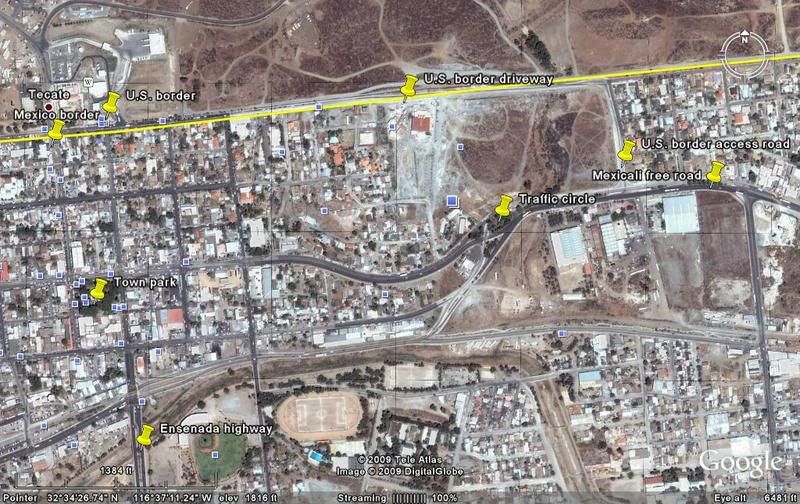
The entrance to the U.S. border 'driveway' is just east of the traffic circle, east of downtown on the Mexicali Free road.

I will try and post some photos for you!

Finding border road in Tecate

David K - 3-2-2009 at 06:58 PM

See if this helps!


David K - 3-2-2009 at 07:03 PM

Coming from Ensenada on Hwy. 3 or just down the hill from the toll road at the Hwy. 3 interchange... you will fork off to the right (well signing Garita USA. Hwy. 94, San Diego, etc.) along the railroad tracks on a 4 lane street.... goes to the 'traffic circle' (Free Mexicali hwy.) then soon make a left turn to access the U.S. border (well signed).

You must go to the east side of town to the access road, no short cuts from downtown streets!

[Edited on 3-3-2009 by David K]

Pescador - 3-3-2009 at 12:13 PM

We were in a hurry to get home and we got to Ensenada around 5:30 or so on Tuesday of last week, and decided that most of the workers would be done for the day which should allow an easy trip from Ensenada to Tecate. Actually all went well and while there was some gravel and a few rough sections closer to Tecate, it was still a good drive and we hit the border at 8:00PM with no wait at all. I was expecting it to be much worse following the discussio here but the Dodge truck, with Lance Camper and a cargo van did very well and while I would have preferred to drive the last few kilometers in the daytime, it was ok.

McNulty - 3-3-2009 at 07:28 PM

I drove that road for the first time coming back from a trip to Guerrero Negro over presidents weekend in very heavy rain, which definitely added to the experience. There were some huge puddles from the rain, and the road was less than perfect but what do you expect when you're in mexico?
All I know is that flying through those puddles sure cleaned off all the salt from the bottom of my car after driving on the salt flats in GN.:biggrin:

Bajahowodd - 3-4-2009 at 12:41 AM

I remember before Homeland Security decided to start really checking things out and delaying passage, you could drive straight up to the border on the road that passes the town park. At least now, they are not clogging the main part of town with border backup.