In 2003, Bruce Barber published his highly detailed guide of his discoveries and explorations in the desert north and south of San Felipe.
The book cover and the book title make the statement totally true that you cannot judge a book by its cover!
The book has really nothing to do with the sea or the sand beaches... It does have a lot to do with the geology and natural history of the San Felipe
desert region. Details of desert trails leading to interesting geological sites, canyons, petroglyphs and palms are what one finds in this guide.
Bruce had done a major search for the Lost Melchior Diaz grave (1541), that may have been discovered by Walter Henderson back in the 1930's with some
directions provided in Choral Pepper's Desert Magazine and her 1973 Baja missions, mysteries and myths book.
Because I have the original letter of directions from Walter Henderson, given to me by Choral Pepper, I contacted Bruce back in '03.
We have done plenty of emailing ever since and met at the Pyramid Resort book event, too.
The book is valuable to anyone who finds the desert, canyons, and geology interesting... Bruce said I could share with you some of the maps that mark
sites and roads covered by the book.
To order your own copy:
..of Sea and Sand." ~A Drama of Two Living Deserts~ by Bruce F. Barber, contains over 360 pages of desert exploration in northern Baja and Sonora.
$12.95 from Lavalands Publishing, PMB 480, P.O. Box 9019 Calexico, CA 92232-9019
Maps from the book to follow...
[Edited on 9-29-2010 by David K]
David K - 5-16-2009 at 08:22 AM
1) Palmas Azules
2) Cantú
3) Los Tanques
4) Tajo
5) Carrizo
6) Guadalupe
7) La Mora
8) PalomarDavid K - 5-16-2009 at 08:25 AM
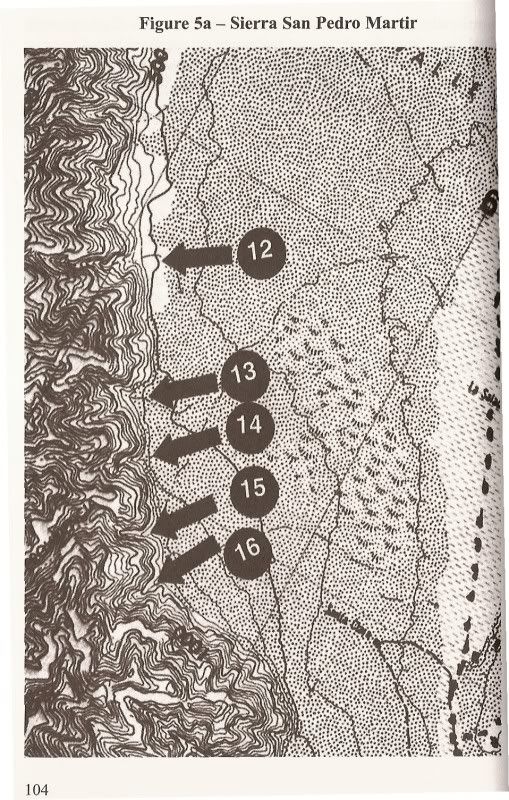
12) Esperanza
13) Copal
14) Copalito
15) Diablo
16) DiablitoDavid K - 5-16-2009 at 08:27 AM
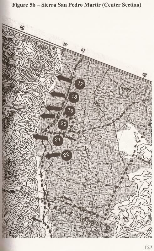
17) Providencia
18) Teledo
19) En Medio
20) Oso
21) Cajon
22) BarrosoDavid K - 5-16-2009 at 08:29 AM
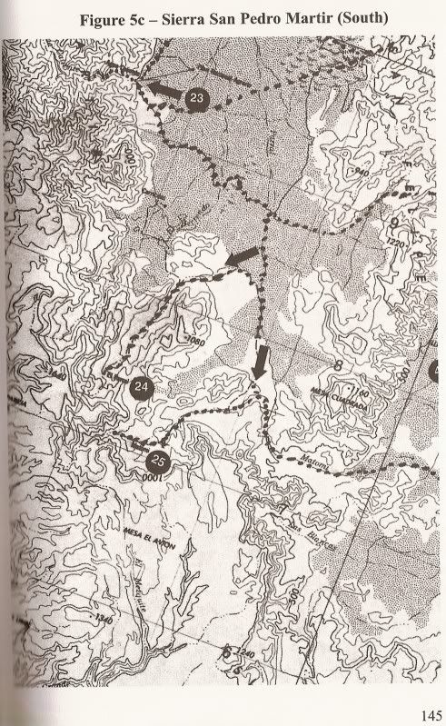
23) Agua Caliente
24) Parral
25) MatomiDavid K - 5-16-2009 at 08:34 AM
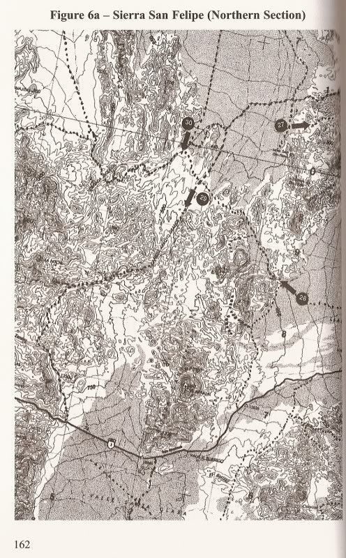
27) Diaz Valley (just west of La Ventana [#26] on Hwy. 5)
28) Pinta Pass
29) Arroyo Grande
30) Arroyo Jaquegal (Pole Line Road route)David K - 5-16-2009 at 08:39 AM
31) Calamity Canyon road (Km. 150-151)
32) Clamshell Canyons 1 & 2 (1: Km. 166+, 2: Km. 155)
33) Powerline Pass
34) Diatom Falls
35) Ram's Head CanyonDavid K - 5-16-2009 at 08:45 AM
36) Hidden Valley
37) Arroyo Chanate (not on map, but same road as #36)
38) Arroyo Huatamote
39) Coyote Caves
40) Cougar Flats
41) Pumpkin Rock (misnamed in book as #40 also)
42) Sulfur Springs North
43) The Sulfur Mines
44) Sulfur Springs South
50) Valley of the GiantsDavid K - 5-16-2009 at 08:51 AM
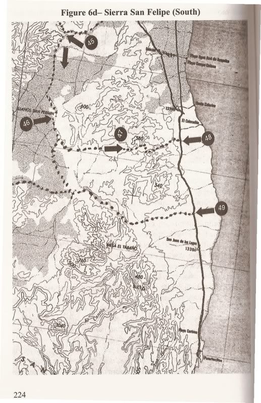
45) Crazy Horse Canyon (aka Cañada el Parral or Azufre Wash)
46) Apache Tears
47 & 48) map numbers not mentioned in book text, but route described on pg. 232+
49) Arroyo MatomiDavid K - 5-16-2009 at 08:55 AM
Now, you can see from all the listings on these maps, there is plenty to see and do in this part of Baja that doesn't involve the beach or fishing!
Great for windy days when you can't go out fishing... or you enjoy off roading and exploring!
Get Bruce's Book for the details on all these sites... and much more!
"...of Sea and Sand." ~A Drama of Two Living Deserts~ by Bruce F. Barber, contains over 360 pages of desert exploration in northern Baja and Sonora.
$12.95 from Lavalands Publishing, PMB 480, P.O. Box 9019 Calexico, CA 92232-9019
[Edited on 7-26-2013 by David K]
David K - 5-17-2009 at 08:46 AM
Perhaps some of you from El Dorado Ranch who have traveled with Bruce Barber or been to some of the places pointed out in his maps, have photos? I
know BajaLou has been to many of the places... Bruce even names Lou in his book!
I have photos of canyons Guadalupe, Matomi, Parral, Agua Caliente, Cajon, 'Crazy Horse', also the sulfur mine, and the 'Apache Tears' area... of the
places on his map...bajalou - 5-17-2009 at 09:46 AM
When I first met Bruce - about 14 years ago - I told him my goal was to know how to find all the places he knew in the Sierra San Felipe, Valle Chico
and Sierra San Pedro Matir areas. I succeeded.
If you follow the link below in my signature labeled "Valle Chico" you will find many of these places marked and most have pictures attached.David K - 5-17-2009 at 01:47 PM
Thanks Lou!
Thanks for sharing!
Ken Cooke - 5-29-2009 at 11:25 PM
I will definitely purchase my own copy since I know it has so much of the good stuff inside.David K - 5-30-2009 at 07:31 AM
I know you will enjoy the details Ken... Instead of just driving on bad roads and running tires up boulders... You will be also able to visit and
describe some really cool natural sites out there!David K - 10-29-2009 at 03:45 PM
Just was reading some of Bruce's book about the area where he searched so hard for the Melchior Diaz gravesite...
Barber even thinks he found the best area to find it (Map 6a #27 'Diaz Valley')... Bruce was figuring that La Ventana was where Walter Henderson began
his walk, however... (Because that was how Choral Pepper told the story in the 1980's and earlier). Choral's updated/ unpublished book clears up that
error... and that is now posted on Baja Nomad.
Plenty to see and do around San Felipe that isn't on the beach!
If Coco held a used 4x4 sale...
Ken Cooke - 10-30-2009 at 05:06 PM
Quote:
Originally posted by David K
Quite a big group of Jeepers there, Ken!
He'd be about $250,000.00 richer (when the photo was taken before the great recession).David K - 9-29-2010 at 11:54 AM
More areas to explore... just turn your back to the sea, and look inland!Maderita - 10-1-2010 at 12:20 AM
I just noticed that some canyons on "Figure 4 - Sierra de Juarez" are incorrectly labeled. Not that there is a problem with that. The worse the maps,
the better for wilderness and adventure.David K - 10-1-2010 at 10:35 AM
Quote:
Originally posted by Maderita
I just noticed that some canyons on "Figure 4 - Sierra de Juarez" are incorrectly labeled. Not that there is a problem with that. The worse the maps,
the better for wilderness and adventure.
I am not as keen on the Juarez canyons, although I have been to Guadalupe many times, El Mano (south of Palomar) twice, and Vibora (not listed)
once... To me #3 & 4 are mixed... Tajo is the big daddy canyon of the Juarez!PaulW - 7-25-2013 at 07:18 PM
Quote:
Originally posted by David K
Quite a big group of Jeepers there, Ken!
==========
Yes pretty active for desert trips and camping trips.
I am the outcast by driving a Bronco. There are a few others like Samis and various SUVs. Only a very few with hard core stuff.
I think I am the only one to ever get stranded.
PWKen Cooke - 7-25-2013 at 10:46 PM
Quote:
Originally posted by PaulW
Quote:
Originally posted by David K
Quite a big group of Jeepers there, Ken!
==========
I think I am the only one to ever get stranded.
PW
I got stranded too!David K - 7-26-2013 at 09:28 AM
That's why you should always invite a Toyota along... JohnMcfrog - 7-26-2013 at 10:03 AM
Canyon Tajo was my favorite canyon for many years. There were over 4000 blue fan palms and a beautiful series of pools going all the way up to the
head wall. We would hide the truck in an arroyo and do a compass bearing on an entry point, so we could find the vehicle in the desert coming back.
Storm clouds brewing over Canyon Tajo
Canyon Tajo pool
Another Canyon Tajo pool
Rock scrambling in Tajo
Juanito
[Edited on 7-26-2013 by JohnMcfrog]
[Edited on 7-26-2013 by JohnMcfrog]David K - 7-26-2013 at 10:09 AM
Very nice John!
A long ago Nomad named 'jide' has some nice Tajo pics and other area sites, too... I made him a web page: http://www.vivabaja.com/jide/