BajaNomad

Garmin GPS map of Asuncion

twogringos - 5-26-2009 at 11:58 AM

I am building a Garmin compatible GPS map of Asuncion. It is a work in progress. I currently have only the roads entered, and as such, it's not really too useful. No one gets lost in Asuncion. On our next stay this August, I'll add street names and POI's. In the meantime, if anyone would like a copy please U2U me.

The map can be loaded directly into a GPS (Google "Img2gps") or can be viewed in Garmin Mapsource. The map can be loaded over Bicimapas Baja topos in the GPS to provide extra detail in Asuncion.

Attached is a screen shot of the map from Mapsource.

AsuncionGPS.jpg - 17kB

Stickers - 5-26-2009 at 01:04 PM

Nice little map but a North arrow would be nicer for us disoriented types. ;D

David K - 5-26-2009 at 02:02 PM

Check the spelling of main street... Thanks for sharing your map!

Stickers, unless indicated otherwise 'North' is always on the top... and I believe that is the case with the Asuncion map, as well.;D

tripledigitken - 5-26-2009 at 02:14 PM

My guess the ocean is on the right in the map, if that is so north would be at the bottom of the page. But I'm coming off 4 days of fun in the sun and I could be wrong.

Ken

David K - 5-26-2009 at 02:20 PM

Yes Ken, the ocean is on the right... and it is south and southeast of town... the sun rises over the ocean there. Asuncion is out on the Vizcaino Peninsula... along the south side of the west pointing peninsula.

Baja is an interesting land with many unusual geologic chacteristics!

tripledigitken - 5-26-2009 at 02:38 PM

You are correct sir. I just looked at a map!

Ken

shari - 5-26-2009 at 03:01 PM

Looks like our house is just off the map at the bottom! Cool. Oh and lots of people get lost as there are so many little roads...took me a couple years to figure out but then again I AM blonde.

comitan - 5-26-2009 at 03:15 PM

I think you may have a problem with no name streets.:lol:

shari - 5-26-2009 at 03:26 PM

yeah...most addresses are s/n (without number) on s/n street (without name) plus on the "plan" the roads are not actually roads....the roads people made and use arent on the map!!! which is nice...jejejeje
the stadium is actually the cultural centre and the stadium is the big green square closer to the entrance of town and the red line is rather confusing as this looks like the road in front of redmesas house and birddogs and is not the highway...that street is called Pargo. Our street along the west coast side is called Almeja...and I think in front of the coop on the point is Delfin.

bajamigo - 5-26-2009 at 03:41 PM

If I tell my 760 to take me to Juan & Shari's place, will it give me turn-by-turn directions?
:D

[Edited on 5-26-2009 by bajamigo]

redmesa - 5-26-2009 at 05:04 PM

another view of Bahia Asuncion

sorry, just learning to post pics.

redmesa - 5-26-2009 at 05:08 PM


map of bahia asuncion (small).JPG - 30kB

Udo - 5-26-2009 at 05:59 PM

That is really cool of you to post this map of BA.
I'm sure Shari and Juan can name all the streets!

fishingmako - 5-26-2009 at 06:00 PM

It will direct you, but you have to have an address.

shari - 5-26-2009 at 06:22 PM

its easy to name the streets as most of them are called S/N...sin nombre!:lol: I dont think the GPS knows my address cause I just made it up.

redmesa - 5-26-2009 at 07:35 PM

David K ... I think I sent you the map. One just never knows in the digital world. Shari may know the date of this map.

Stickers - 5-26-2009 at 09:51 PM

Quote:
Originally posted by David K
Stickers, unless indicated otherwise 'North' is always on the top... and I believe that is the case with the Asuncion map, as well.;D


Thanks David but I always figure the ocean is on my left when facing North. This is a problem I have being a Californian, it doesnt matter where I am the ocean is always West. Whenever I am on an island I am a lost-cause finding my way around. Kinda like the earth is flat mentality. :(

twogringos - 5-27-2009 at 06:53 AM

Thanks, All for the input. There are more street names and labels on the map that do not appear at this zoom level. Others I do not remember and so will wait until I can check them on the ground. The map does extend south to Shari's house, it just doesn't show in this view. I compiled the map to use with Bicimapas and left the coastline to that program. I have compiled it with a topo map that includes the coastline for standalone use.

The green square closer to the entrance of town I labeled "Baseball". I'll have to figure out local names and I'm sure Shari can help. See you about Aug. 11.

shari - 5-27-2009 at 07:22 AM

this will be a fun project and helpful for visitors...I'm in!

Here it is...

David K - 5-27-2009 at 07:27 AM

Quote:
Originally posted by redmesa
David K ... I think I sent you the map. One just never knows in the digital world. Shari may know the date of this map.


capt. mike - 5-27-2009 at 09:49 AM

dos gringos - are you going to refine this more? nice work.
how about blowing it up a bit and spotting where the airport is in relation to town and the high way?

thx.

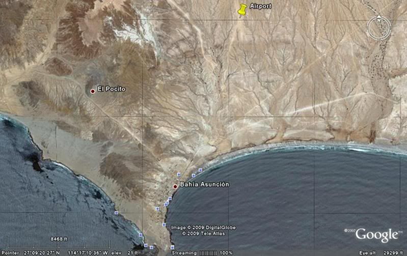
Asuncion from space!

David K - 5-27-2009 at 04:12 PM

The first two are the view at 2,500' with north at the top:


This one is at 8,500' with the airport marked with a yellow pin (about 2 miles from town):


This is at an angle, still looking north (at the top)... Shari and Juan's place near the lower left corner.


capt. mike - 5-28-2009 at 06:22 AM

is the number relative to horizontal scale or elevation above ground/sea level?

twogringos - 5-28-2009 at 07:33 AM

Shari, I was hoping you would help. I have put my working map on a file share site (too large to post here). Maybe you could print it out and mark it up.
http://www.keepandshare.com/doc/view.php?id=1211200&da=y... (PDF 55K)
or
http://www.keepandshare.com/doc/view.php?id=1211201&da=y... (JPG 205K)

capt. mike, I don't think I can enlarge the map without starting over, but I'm green at this. I'll experiment. I know I can add the runway if I had coordinates at each end, I 'm just not sure I can enarge my google earth photo (see links above) to trace over it.

David K - 5-28-2009 at 07:53 AM

Quote:
Originally posted by capt. mike
is the number relative to horizontal scale or elevation above ground/sea level?


The bottom numbers (GPS & elevation is for the pointer, and means nothing as far as the image posted).

The scale bar and number of feet above it represent just that, the scale of the map shown... and more like the approx. elevation of the view. The first two are about 2,500' up and the third about 8,500' up... high enough so I could show the town and your airport... if you ever fly out there!

In Shari's slide show, she shows two planes parked out there.

Bajaboy - 5-28-2009 at 07:57 AM

Any idea how to post or share a Google Earth file? I created a map of town with many of the businesses, etc., a while ago. The map is too populated for a useful screen shot.

David K - 5-28-2009 at 08:02 AM

Quote:
Originally posted by twogringos
Shari, I was hoping you would help. I have put my working map on a file share site (too large to post here). Maybe you could print it out and mark it up.
http://www.keepandshare.com/doc/view.php?id=1211200&da=y... (PDF 55K)
or
http://www.keepandshare.com/doc/view.php?id=1211201&da=y... (JPG 205K)

capt. mike, I don't think I can enlarge the map without starting over, but I'm green at this. I'll experiment. I know I can add the runway if I had coordinates at each end, I 'm just not sure I can enarge my google earth photo (see links above) to trace over it.


capt. mike - 5-28-2009 at 12:41 PM

thx DK - i was thinking elevation then imagined the view from my bird's eye at 2500' or 8500' and thot the image seemed higher up than that.
i am pretty weak at using googley earth. fun stuff tho.

yes - i need to get there one of these days. right now i am simply not equipped to go from a time standpoint. but it will be there a while longer i am figuring!

David K - 5-28-2009 at 02:45 PM

Quote:
Originally posted by Bajaboy
Any idea how to post or share a Google Earth file? I created a map of town with many of the businesses, etc., a while ago. The map is too populated for a useful screen shot.


Not sure if you are talking about something other than a single image Zac? If you mean your personal file of places on Google Earth... I think you can only post a link to that, as a single image would need to be so high to show all of Baja, the marker pins wouldn't be well defined. Perhaps bajalou or another Google map user can help?

When I want to show a Google Earth image, as I have above, I first save it to a file on my PC (let me know if anyone needs the steps to do that).

Second, I open up my photobucket.com album then copy that file to Photobucket (set on 15" screen size reduction so it dowsn't distort the Nomad page wider than standard monitors can show).

Third, I paste the url [IMG] link onto the Nomad page.

Neal Johns - 5-28-2009 at 09:31 PM

BajaBoy,
To send someone an email containing a jpg picture of what is on your Google Earth screen, in Google Earth, click File, Email, and then Email Image.

To send someone an email containing the info that will open the image on your screen in their copy of Google Earth, in Google Earth, click File, Email, and then Email View.

To send someone an email containing all or part of your Google Earth "My Places", check the box(s) of the places you want to send and then in Google Earth, click File, Email and then Email Placemark.

For capturing any image on your monitor, I use the free version of PrintScreen from http://www.gadwin.com/download/

[Edited on 5-29-2009 by Neal Johns]

Bajaboy - 5-28-2009 at 09:32 PM

Thanks Neal!

Cyanide41 - 6-1-2009 at 11:53 AM

twogringos.... just nit picking... but shouldn't it be "Juarez"?

David K - 6-1-2009 at 04:20 PM

Quote:
Originally posted by Cyanide41
twogringos.... just nit picking... but shouldn't it be "Juarez"?


I may have not been 'loud' enough when I posted this a few days ago :light: :

posted on 5-26-2009 at 02:02 PM

Check the spelling of main street... Thanks for sharing your map!

805gregg - 6-1-2009 at 08:04 PM

I'm not trying to start anything here, but why would you need a map? It's so small, if you ask directions, I'm sure everyone knows all the residences.

David K - 6-1-2009 at 09:21 PM

Basically a one business street town... I was surprised to see such a detailed 'street' map that Shari had... Shows some planning!

Cyanide41 - 6-2-2009 at 06:27 AM

Quote:
Originally posted by David K
Quote:
Originally posted by Cyanide41
twogringos.... just nit picking... but shouldn't it be "Juarez"?


I may have not been 'loud' enough when I posted this a few days ago :light: :

posted on 5-26-2009 at 02:02 PM

Check the spelling of main street... Thanks for sharing your map!


What's that DK? Could you speak up? :P

Your right you did say that a few days ago. It was Monday. That's my excuse

twogringos - 6-2-2009 at 07:32 AM

I acknowledged the typo 5-27. Sorry I can't go back and edit the photo.

TwoGringos

DianaT - 6-2-2009 at 09:27 AM

Hi,

We are looking forward to seeing both of you again in August in Bahia Asuncion.

However, I am curious about this map project. I am a person who gets lost in parking lots, and I can't imagine getting lost in Bahia Asuncion. And the majority of streets do not have names, if they really are streets.

Also, we know that there are plans of putting a street behind our house and another one in front of your home, soon, we are told. :lol::lol:

There are roads all over Bahia Asuncion that do not exist. You can drive on one today, then the land owner looks at the map in the land office and sees that it is not a road and blocks it off. Then it takes about 3 days for a new road to appear---just as soon as the ground is a little more packed from cars driving around where the road is blocked.

Usually we find people with directions like, drive up the hill behind the Tel Cel, look for a white house with lots of plants, and my red truck. So, a map would not really help.

And, thanks to our new delegado, we now have signs that point to the airport and to the dump. Boy, talk about lots of "roads", that area is covered with them. But even there, It is difficult to get really lost. We just look for the power lines and head that direction.

But, I am sure there is a good reason and it could be fun to see how many changes need to be made every month or so.

See you at fiesta time!

Diane

[Edited on 6-2-2009 by jdtrotter]

msteve1014 - 6-2-2009 at 04:10 PM

I have a picture of a "map" of a small part of La Bocana, where my house is. It shows the streets and the lots with the names of the people that own the lot. Except that most of the streets don't exist. There are streets where none are shown, and people have built homes where there should be a street:rolleyes: I love it.

shari - 6-2-2009 at 07:26 PM

Actually David, there are LOTS of businesses worthy of finding that are NOT on the main drag. There are clothing stores, a nice jewellery store, an excellent taco restaurant type place, killer hot dog stand, the telegraph office, depositos, the cultural center, clothing stores, hardware stores, restaurants etc. that are off the main street and sometimes hard to find...even for me. A map would be usefull IMHO particularly for those hard to find businesses.

capt. mike - 6-3-2009 at 06:20 AM

the telegraph office,

i find that fascinating!

shari - 6-3-2009 at 07:14 AM

the Telegraph office is really the heart of the village and suffers many cardiacos! It is where everyone wires money to their kids on college, their grandmas in their villages, pays the phone bills, collects the old age pensions, is the post office too, and the bank where people get paid from the coops. It is also Western Union where gringos send $ to builders.

Problem is with changing technology, it is suffering...the coops used to pay in cash and so people would make deposits there into their bank accounts...(it works with Banamex, Bancomer, Banorte and HSBC) and pay their bills there. But now people can pay bills online and fishermen's salaries are deposited in the banks in ensenada and so the families have to withdraw the money with a bank card.

So this means that there is little money being deposited and everyone wants to withdraw...so there is often no money in the coffers now. It is turning out to be a real problem...besides the fact there is only one agent so on payday, there is a very very long wait....and by the time I get to the window, they run out of $. We desperately need a bank here now with this new change in payroll. Well....we will finally have a family bar soon...hopefully a bank is to follow!
So word to the wise...make sure you feul up with pesos and gas in Vizcaino before heading to paradise...oh yeah and Vodka because the new residents clean out the supply real fast!

David K - 6-3-2009 at 08:47 AM

Quote:
Originally posted by shari
Actually David, there are LOTS of businesses worthy of finding that are NOT on the main drag. There are clothing stores, a nice jewellery store, an excellent taco restaurant type place, killer hot dog stand, the telegraph office, depositos, the cultural center, clothing stores, hardware stores, restaurants etc. that are off the main street and sometimes hard to find...even for me. A map would be usefull IMHO particularly for those hard to find businesses.


Good reason for a good map, then!