BajaNomad

Chapala to Ocean Loop

TMW - 7-12-2009 at 03:20 PM

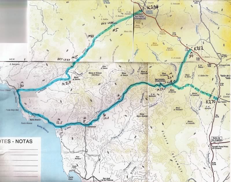
I gave a trip report in the trip report section but I wanted to be a little more specific on the loop starting at the Rancho Chapala area KM234 out to the ocean and back thru San Antonio to hwy 1 at KM252. This is a 75 mile off road trip that's fun and interesting. It is also two short cuts between hwy 1 and the ocean road if needed.

I did this in my 2004 GMC Z71 4x4. The road does not require a 4x4 but does require higher ground clearance that most cars have so an SUV, Van or truck is the choice. I said 4x4 is not necessary but keep in mind that there are two large silt bed sections that could be trouble. If traveling alone be very very careful what lines you take or you could find yourself high centered and in most of these areas a winch won't help much since there is not much to hook to. You could try a sand anchor but I think a high lift jack with wood to put under the wheels might be the better choice.

Note all of my GPS reading are Datum 27 in hrs-mins-sec.

The start is off hwy 1 @ .2 miles north of KM234. The road is easy to spot from the hwy.

At 3.4 miles is the first dry lake bed, 29-21-20x114-25-41 @2076ft. Off to your left at a distance is a concrete marker. As you look west there is a dark hill the road passes to the right of that hill.

At 5 miles your off the dry lake.

At 8 miles is a Y go right. If you go left it will come back to the road in about .3 miles.

At 8.3 miles start down hill.

10.6 miles bottom of hill, 29-18-10x114-30-32 @1297ft.

At 15 miles is an open valley looking area with the 2nd dry lake bed. 29-15-27x114-33-11 @1152ft.

At 17 miles up hill out of valley area. 17.2 miles is a sand hill on the left for reference. At 17.3 miles you can see the ocean.

At 20.7 miles down hill with several routes to take. Suggest most used one, others may be washed out from rains.

At 22 miles your down the hill 29-12-07x114-37-11 @322ft.

At 28 miles is silt beds for a mile or more. 29-10-42x114-41-25 @43ft.

At 30 miles your at the ocean. 29-10-49x114-44-20 @0ft.

I zero'd my odometer here for the section south.

At 11 miles I pulled over to the ocean @ 29-05-42x114-37-35 @0ft.

At 12.5 miles Y go left 29-05-22x114-36-36 @0ft. Right goes thru a marsh area and over the hill to a fish camp.

I zero'd my odometer at the Y.

At .6 miles Y go left.

At 3.5 miles Barb Wire fench with opening for vehicles. 29-06-03x114-33-24.

At 4.3 miles Y go right toward windmill and pass by it.

At 5 miles jct with coastal road from the south. 29-05-35x114-32-05 @135ft. Across the wide open area toward the north are several ranch buildings.

At 8.2 miles Y go left. At 8.6 miles Y go left.

At 9.1 miles Y left is to Rancho Las Palomas, go right.
Rancho Las Palomas @ 29-07-48x114-29-01 @237ft.

10.8 miles Y left to Rancho Las Palomas, go right.

This is a silt area with multiple lines. Pick your best and watch out. I did not have any problems but if it had rained who knows.

At 11.8 miles out of the silt area and into the sand wash.

At 14.5 miles out of the sand wash and start up mountain @ 29-09-23x114-25-52 @600ft. Abandoned rancho on right.

At 15.6 Y go right onto new road 29-10-06x114-25-32 @1083ft.

At 16.1 miles jct with old road go straight.

At 18.4 miles road from left. At 20.1 miles road from left. At 24 miles road from left. I think the last two roads take you to San Antonio. I never saw it coming out but it is close to the next rancho which is near by. San Antonio has several tall palm trees, a well and a couple of adobe buildings in disrepair. I've been there several times, the last time about three years ago.

At 24.5 29-11-42x114-17-31@1095ft palm trees concrete dam and watering for animals.

At 25miles Y ranch to right go either way, I went left.

At 25.6 Y same ranch to right go left. The road by the ranch is the better road.

At 26.4 miles jct 29-11-44x114-16-53@1674ft. go straight house to the left on hill. Road to right meets hwy 1 @KM270.

At 34 miles hwy 1 @KM252.

Enjoy the ride.

[Edited on 7-12-2009 by TW]

TWST-15.jpg - 27kB

The previous pix was from last Jan.

TMW - 7-12-2009 at 03:23 PM

You can see the dark hill with not so dry lake at the time to the right. Here is a better pix from last week.

TWST-7.jpg - 15kB

The road is not bad.

TMW - 7-12-2009 at 03:25 PM

No big rocks to worry about.

TWST-10.jpg - 23kB

There are silt beds as you get near the ocean

TMW - 7-12-2009 at 03:28 PM

The road is not used much except fore the people at the fish camp just north of where the road meets the ocean.

TWST-12.jpg - 26kB

From the ocean back to hwy 1

TMW - 7-12-2009 at 03:30 PM

The road up the mountain is mostly a new graded road. Maybe that will change with the winter rains.

TWST-13.jpg - 32kB

David K - 7-12-2009 at 07:51 PM

Great TW!!!

Paulina - 7-12-2009 at 08:11 PM

That is on our list of things to do.

Nice tulip notes!

P<*)))>{

bajaandy - 7-13-2009 at 07:19 AM

Love it. I keep meaning to get down there and do that loop, but it seems like one thing after another keeps me from going. Thanks for the TR and the pics.

One of these days...

The TW Loop Map

David K - 7-13-2009 at 08:22 AM


That looks cool, TW!

Ken Cooke - 7-13-2009 at 11:11 AM

The silt beds near the ocean look like an action adventure location for the Jeeps one day. Gotta love that Baja 4WD'ing!!:bounce::bounce:

Paulina - 7-13-2009 at 11:19 AM

That is quite a short cut. Thank you for putting up the map DK so I could picture what Dern's been talking about for years. (visual person here)

I think we will be passing it up once again this summer as we'll be towing the panga. What has been taking us so long to make this adventure is that we are rarely on the Hwy without something being towed behind us.


P<*)))>{

That cuts down on the fun quotent

Ken Cooke - 7-13-2009 at 11:25 AM

Quote:
Originally posted by Paulina
What has been taking us so long to make this adventure is that we are rarely on the Hwy without something being towed behind us.


P<*)))>{


Could you set up a base camp someplace secure in order to explore more places in Baja?
For instance, in Cataviña you would be out of the way, but fairly secure. The reason I
bought my Jeep was to see everything that Baja has to offer. The downside, however, is
the lack of interior space/comfort.

Paulina - 7-13-2009 at 11:36 AM

ken,

You have a good point. Our home is in Punta Banda, we keep everything there. We get there, spend a few days, pack up what we need for the season, then hit the road south. Our other "home" is in Bahia de Los Angeles where we unload all the seasonal stuff we tow down. We have the most time for exploring in the summer, so when time comes where we welcome the cooling effect of the Pacific side we lock things up and head that direction. We explore other places as well. It is usually on the trips south, as we are passing TW's short cut that we say, "One of these days..." We just need to make one of these days happen.

P<*)))>{

Ken Cooke - 7-13-2009 at 11:51 AM

Paulina,

That sounds like quite an operation you have set up. I'm sure there are plenty
of places most 'Nomads wished they could travel to given the amount of time
you have at your disposal. Hey, its a trade off, but I'm sure its a real fun one.

Paulina - 7-13-2009 at 12:45 PM

Quote:
Originally posted by Ken Cooke
... given the amount of time
you have at your disposal. Hey, its a trade off, but I'm sure its a real fun one.


Being a teacher for many years has provided me with plenty of off work time to go home as it is. We live simply, no credit cards ie debt, and plan for our journeys home and adventures that stem from there. It's not really time at our disposal, it's time that is planned and saved for that will only add to the future when we plan to stay there once and for all.

P<*)))>{

David K - 7-13-2009 at 04:02 PM

Work to Live instead of Live to Work... Yes indeed!

Paulina, I think it was 4baja who first reported on that shortcut to the Pacific from L.A Bay many years ago... The one at Km. 270... It is just a stone's throw south of where the old L.A. Bay road meets the highway (between El Crucero and the modern L.A. Bay jcn.)

You can easily follow it on Google Earth or Wilimapia.org at high resolution.

When the fishing is bad at Bahia (well when the wind blows, as the fishing is never bad)... or it is too hot... just cross over to the west coast of Baja, 70 miles away!

Paulina - 7-13-2009 at 05:38 PM

David,

We head over to the pacific side every summer. It's part of our routine. Not because fishing is bad, because we only fish for our dinner, there's always enough for that. Fishing is never bad for us as we don't take any home. We head west because we want a break from August's furnace that is stuck in the on position over in Bahia.

P<*)))>{

David K - 7-13-2009 at 05:40 PM

I remember when we saw you at Bahia Asuncion, July of 2007!


[Edited on 7-14-2009 by David K]

707 160r.JPG - 32kB

Paulina - 7-13-2009 at 05:42 PM

...and we'll probably be there around the same time this year as well. That was quite the surprise though! Baja can be quite a small world at times.

P<*)))>{

On edit:

Oh Gawd, I knew you'd post that photo!

[Edited on 14-7-2009 by Paulina]

David K - 7-13-2009 at 05:44 PM

Hey, we are all CASUAL in Baja, aren't we???

TMW - 7-14-2009 at 07:03 AM

Here is a good video on youtube of a MC going thru a silt bed.

http://www.youtube.com:80/watch?v=rL7ygCadtEY

David K - 7-14-2009 at 07:18 AM

Quote:
Originally posted by Paulina
...and we'll probably be there around the same time this year as well. That was quite the surprise though! Baja can be quite a small world at times.

P<*)))>{

On edit:

Oh Gawd, I knew you'd post that photo!

[Edited on 14-7-2009 by Paulina]


Hey Paulina... Here's a photo of Dana Point Dave, Whistler, and me at my Viva Baja #1 party (in 2000)... and if you look behind me just inside the doorway... Yep, that's YOU! It's been a wild 9 years hasn't it!


Ken Cooke - 7-14-2009 at 07:25 AM

Thanks for hosting that party, David.

I really enjoyed it, and think about how it brought so many people together.

David K - 7-14-2009 at 08:13 AM

Quote:
Originally posted by Ken Cooke
Thanks for hosting that party, David.

I really enjoyed it, and think about how it brought so many people together.


El gusto es mio... I remember you guys came in a Jeep, yes?


See many of today's Baja Nomads in 2000 who are still with us, and a couple who are in the great Boojum Forest in the Sky at http://vivabaja.com/vivabaja

2003 1/2 Wranger Rubicon

Ken Cooke - 7-14-2009 at 08:46 AM

Quote:
Originally posted by David K
Quote:
Originally posted by Ken Cooke
Thanks for hosting that party, David.

I really enjoyed it, and think about how it brought so many people together.


El gusto es mio... I remember you guys came in a Jeep, yes?


See many of today's Baja Nomads in 2000 who are still with us, and a couple who are in the great Boojum Forest in the Sky at http://vivabaja.com/vivabaja


No, I was still driving my infamous FORD RANGER. You forget so quickly....

mtgoat666 - 7-14-2009 at 09:05 AM

Quote:
Originally posted by Ken Cooke
Could you set up a base camp someplace secure in order to explore more places in Baja?
For instance, in Cataviña you would be out of the way, but fairly secure. The reason I
bought my Jeep was to see everything that Baja has to offer. The downside, however, is
the lack of interior space/comfort.


ken,
why don't you get a small off-road trailer to haul your camping gear? that way you can set up your base camp anywhere you can pitch a tent.

Ken Cooke - 7-14-2009 at 09:13 AM

Quote:
Originally posted by mtgoat666
ken,
why don't you get a small off-road trailer to haul your camping gear? that way you can set up your base camp anywhere you can pitch a tent.


I might still do that. When the temperatures drop later this year, I plan to camp out in Joshua Tree (tent), and do more wandering through Baja next Spring.

Paulina - 7-14-2009 at 01:40 PM

Ken,

We have a Sportmobile 4x4 trailer that we may be interested in selling. We can u2u on it as it gets closer to your spring time travels.

P<*)))>{

David K - 7-14-2009 at 09:35 PM

Quote:
Originally posted by Ken Cooke
Quote:
Originally posted by David K
Quote:
Originally posted by Ken Cooke
Thanks for hosting that party, David.

I really enjoyed it, and think about how it brought so many people together.


El gusto es mio... I remember you guys came in a Jeep, yes?


See many of today's Baja Nomads in 2000 who are still with us, and a couple who are in the great Boojum Forest in the Sky at http://vivabaja.com/vivabaja


No, I was still driving my infamous FORD RANGER. You forget so quickly....


Ken, Viva Baja #1 was in October of 2000, so I don't think that Jeep you showed me outside the hotel in San Clemente was a 2003 Rubicon! You said it was Suzanne's Jeep, I thought.

Ken Cooke - 7-15-2009 at 10:12 PM

Quote:
Originally posted by David K
Quote:
Originally posted by Ken Cooke
Quote:
Originally posted by David K
Quote:
Originally posted by Ken Cooke
Thanks for hosting that party, David.

I really enjoyed it, and think about how it brought so many people together.


El gusto es mio... I remember you guys came in a Jeep, yes?


See many of today's Baja Nomads in 2000 who are still with us, and a couple who are in the great Boojum Forest in the Sky at http://vivabaja.com/vivabaja


No, I was still driving my infamous FORD RANGER. You forget so quickly....


Ken, Viva Baja #1 was in October of 2000, so I don't think that Jeep you showed me outside the hotel in San Clemente was a 2003 Rubicon! You said it was Suzanne's Jeep, I thought.


You are 100% right! I forgot about that..:)

David K - 4-23-2010 at 08:02 AM

Bump for Boojum Man

For your GPS, remember what TW said: "Note all of my GPS reading are Datum 27 in hrs-mins-sec."

That's Map Datum NAD27Mexico and the figures (position format setting) is hdddºmm'ss.s"

[Edited on 4-23-2010 by David K]

TMW - 4-23-2010 at 08:56 AM

Probably would not be able to cross the dry (wet) lake bed, just in from Chapala, now. I'm headed down for the NORRA 1000 next week and I may run in just to see if it's wet or not next Thursday, provided I get thru Cocos before dark. Thinking of working my way up the coast from there to do some fishing after the race. If wet I'll go in from KM252 or Santa Rosalillita.

rts551 - 4-23-2010 at 09:03 AM

The Chapala lake bed is still has a lot of water in it

Mexitron - 4-23-2010 at 10:55 AM

And even when it looks dry, check it first--it can still be muddy underneath a dry crust...I know, I got stuck in it at Chapala many years ago!

[Edited on 4-23-2010 by Mexitron]