Route, distance and time? Road conditions? My guess is it's faster to cross and take I-8 through El Centro/ Mexicali but the g/f lives in TJ and
can't cross. It would be me, the g/f, her 19 yo niece and her 7 yo son. Any problems with that? Both the g/f and niece are real lookers They are going to attract attention. bajaguy - 11-15-2009 at 12:29 PM
Uh-oh......where is Fishbuck?????.....Cyanide41 - 11-15-2009 at 12:50 PM
where are the PICS!?!
Basically you are either taking Hwy 2 to Hwy5 or Hwy 1 - Hwy 3 - Hwy 5. I think the 1st option is faster, but I have never taken it myself.bajalou - 11-15-2009 at 01:25 PM
Highway 2 to the toll road around Mexicali, the Highway 5 to San Felipe.Bajahowodd - 11-15-2009 at 01:47 PM
Quote:
Originally posted by Cyanide41
where are the PICS!?!
Basically you are either taking Hwy 2 to Hwy5 or Hwy 1 - Hwy 3 - Hwy 5. I think the 1st option is faster, but I have never taken it myself.
Cyanide is correct about time. That said, the route from Ensenada, Hwy 3, is much more scenic.David K - 11-15-2009 at 04:03 PM
Hwy. 3 east from Ensenada is a calmer, more scenic country drive than going east from Tijuana on Hwy. 2... although that isn't so bad once you are
out of Tijuana.
Tijuana to Ensenada is 70 miles, 1.5 hrs.
Ensenada to Hwy. 5 on Hwy. 3 is 122 miles, 2.5 hrs.
Hwy. 5/3 jcn. to San Felipe is 31 miles, 45 minutes.BajaGeoff - 11-16-2009 at 01:30 PM
Just did this drive over the weekend. We crossed at Tecate and took the 2 to the 5. Road was great and the drive was only about 4 hours to San Felipe
from the time we got into Baja. On the way back yesterday we opted to cross at Mexicali and take the 98 west to the 8 to return to San Diego. That was
also quick and easy except for the border wait, which was just under two hours (we had a non-sentri passenger in the car).
Taking the 3 is much more scenic, but definitely slower, so it really depends on time vs. scenery.DENNIS - 11-16-2009 at 01:47 PM
Quote:
Originally posted by BajaGeoff
Taking the 3 is much more scenic, but definitely slower, so it really depends on time vs. scenery.
They say there's lots of road work going on at the present, just so folks keep that in mind.David K - 11-16-2009 at 02:32 PM
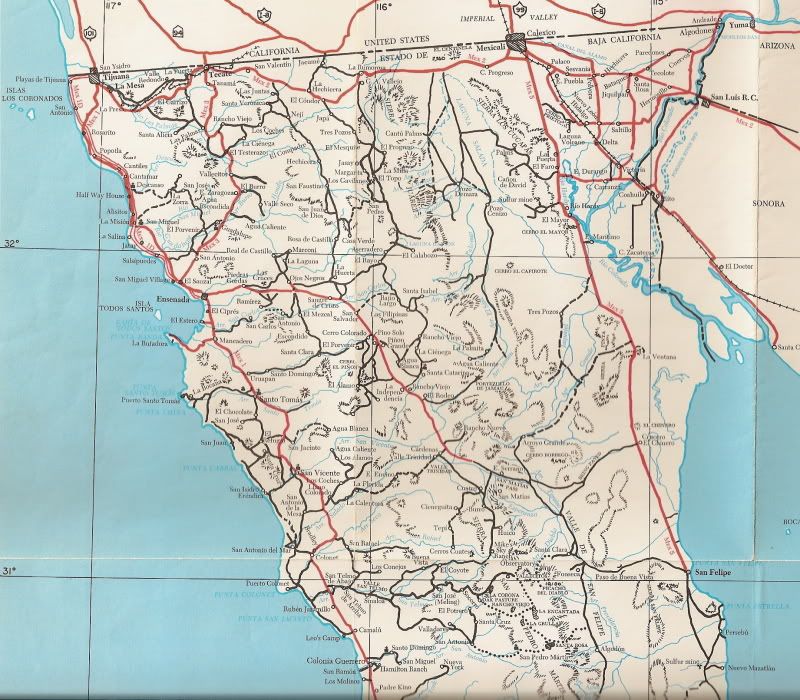
Because alafrontera is new to Baja, let me point out that there are TWO Federal Hwy. 3's in Baja!
The original is a north-south highway from Tecate to (near) Ensenada... completed 1958 and paved in a couple more years.
The 'other' is the Ensenada to San Felipe road, originally designated as state Highway 16 and completed about 1977, then renamed or made part of
federal Hwy. 3. It actually goes to Hwy. 5, at a point 31 miles north of San Felipe.
A map from 1975 of northern Baja (shows pavement reaching Valle de Trinidad and a note beyond saying: 'Being Paved':
[Edited on 11-16-2009 by David K]alafrontera - 11-16-2009 at 09:22 PM
Quote:
Originally posted by David K
Because alafrontera is new to Baja, let me point out that there are TWO Federal Hwy. 3's in Baja!
Well of course, why wouldn't there be? It's a big place.
I may be a Baja noob but I am not unfamiliar with turd world living. In St Thomas there is an "official government issued"
landmark map to help people get around. It includes such gems as "the chicken coop" (which is actually an old nursery overgrown with wild
vegitation now but still mostly fenced in with chicken wire), several bars and vistas, places with names like "four corners", and my personal alltime
favorite; where the dumpster used to be on Hull Bay Road. Moving that dumpster confused a lot of people

 They are going to attract attention.