BajaNomad

Black Mountain

mcfez - 10-28-2010 at 10:33 AM

I am writing these little reviews because there are some folks here that would like detail accounting of a particular area...as I do.

About 9 miles south of Puertecitos. I really like this area for primitive camping. There is no water. No restrooms. No improvements. Primitive yet one can see the highway.

Great area for fishing. Large trigger fish. Lots of pan fish.
Again....this area is coastal rock and cobble stone shoreline. Use of rocks for your sinkers will work great here. Some folks even use spark plugs...I wont use em due to the fact they emit a tiny bit of carbon / oil residue. Using bait that was salted down ---weeks---- prior...the triggers goes nutz.

Several sites to camp at. You'll see a trailer next to a wooden shack. Real nice there. Piles of scallop shells 8 feet high to dig around in. Nice ravine or two to explore. No beach sand.

Other spot is pictured below. NOT for trailers/campers. As one drives past the mountain....you will see a entrance (it's in the picture below)......turn in till you reach a road heading up that hill (in the picture) on the left. Proceed to the top of the hill...on your right...a cove! Yes...and a steep road going to the cove. Road is 300 ft only. Wind protected. Extremely private. One can launch small craft (12 feet or less) or fish off the rocks that are northward. Have a fire going.....you going to need it to cook all that fish!

Puertecitos is 15 minutes away for supplies and help.

bm.jpg - 45kB

David K - 10-28-2010 at 10:56 AM

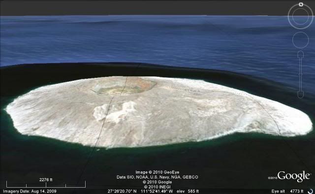
Black Mountain (Cerro Prieto) has a crater at its top...


Bajatripper - 10-28-2010 at 11:02 AM

Quote:
Originally posted by David K
Black Mountain (Cerro Prieto) has a crater at its top...


David, you forgot to mention the snow it the crater:lol:

David K - 10-28-2010 at 11:04 AM

Yah, potassium nitrate snow perhaps?:light:

crater?

mcfez - 10-28-2010 at 11:09 AM

DavidK........You see...every single mile of Baja offers something new...every time...no mater how many times one has been there. Been to Black Mountain as much as in my front yard...and never knew of the crater! Guess where I am going next time. Anyone know of a existing trail up to it?

I was in baja for only 6 days last week...was scheduled for 3 weeks. In those 6 days...I gather so much experience of new stuff in a hundred mile stretch from San Felipe.

Bajatripper...you recommend cross country skiing or downhill there?

[Edited on 10-28-2010 by mcfez]

David K - 10-28-2010 at 11:43 AM

Yes, it was described in the 1962 Lower California Guidebook (pg. 83, 11.2 miles from Puertecitos) about having a crater at its top...

Unless you were a pilot, the only way we land lovers can see it without hiking up, is on Google Earth!

Here is a whole series of views, I just now did:


Looking north:


Looking west:


Looking south:


Looking east:


David K - 10-28-2010 at 12:02 PM

Maybe the next 'visible' crater south is Isla San Luis, with a crater taking a dip in the Sea of Cortez!


castaway$ - 10-28-2010 at 01:44 PM

Tortuga off of Santa Rosalia has a very large crater almost in the center of the island----- David K, google earth picture please since I can't figure out how to put it here.:tumble:

[Edited on 10-28-2010 by castaway$]

sancho - 10-28-2010 at 02:22 PM

You're right about those Triggers, I camped
in a non descript cove about 2 mi. so. of
Puerticitos a few times, before the pavement,
2 mi. was about as far as I got down that road.
I could barely Mtn Bike back to Puerticitos.
I don't know what other species of pesca
inhabit the area, but the Triggers will bend a rod
off of a kayak. I remember G Kira in his book
mentioning Blk Mtn, I believe he camped
just beyond it to the So.

IMAGES POSTED FOR EDUCATIONAL PURPOSES ONLY

David K - 10-28-2010 at 03:05 PM

Larry, my posting of Google Earth images with my friends here is for educational purposes only, I make no income from what I do with them. I also believe Google cannot charge for viewing the images either, because they come from our government (taxpayers) satellites... just like GPS is free. We can see the images on Google, Wikimapia, and other Internet sources... the same images.


Quote:
Originally posted by castaway$
Tortuga off of Santa Rosalia has a very large crater almost in the center of the island----- David K, google earth picture please since I can't figure out how to put it here.:tumble:


I am happy to help...

View north, from south of the island:


Close view looking southeast:


castaway$ - 10-28-2010 at 03:18 PM

Thnks David. Tortuga is a really interesting island, I'm hoping to hike up to the crater next ti me down if I can find a safe place to anchor my boat. I have also heard the diving is excellent there.

David K - 10-28-2010 at 03:21 PM

The closest I have been was sailing by it on the ferry boat, back in 1973!

smlslikfish - 10-28-2010 at 03:36 PM

Do NOT try and drive on the salt flat south of Black mountain. No matter how firm and tempting it looks!

smlslikfish - 10-28-2010 at 03:42 PM

I was lucky we ran into this guy.

David K - 10-28-2010 at 04:01 PM

Quote:
Originally posted by lencho
Quote:
Originally posted by David K
Larry, my posting of Google Earth images with my friends here is for educational purposes only, I make no income from what I do with them. I also believe Google cannot charge for viewing the images either, because they come from our government (taxpayers) satellites...


I understand that and agree with you in great part. I'm not an expert in copyright law, but I think that what Google is presenting on top of that taxpayer-funded information is a value-added product which may be independently copyrightable, and the text which I quoted from their user agreement makes me uneasy.

I have never heard of anyone getting harassed by Google for such republication, but that doesn't mean they might not have the legal right to do so, and I'd hate to put Doug at risk (having advertising here makes this a for-profit operation, I think, which may counterindicate "fair use" privileges).

I've just been experimenting with another technique of presenting such information directly via the Google Earth interface rather than publishing their image on the board; if you can download this file and tell it it run in Google Earth (if it doesn't do so automatically), this technique might present an interesting alternative:

Test of Google KMZ tour

--Larry

Edit: Microsoft, being who they are, messes around with things without asking. If you use Internet Exploder, make sure you SAVE the file as TortugaView.kmz (my IE tries to save it as TortugaView.zip without asking if it should change the name, sigh. Google Earth wants .kmz, not .zip).


[Edited on 10-28-2010 by lencho]


I had a look Larry... well tried to, but my PC doesn't know what program created the file and can't open it.

[Edited on 10-28-2010 by David K]

mcfez - 10-28-2010 at 04:20 PM

Quote:
Originally posted by David K
Quote:
Originally posted by lencho
Quote:
Originally posted by David K
Larry, my posting of Google Earth images with my friends here is for educational purposes only, I make no income from what I do with them. I also believe Google cannot charge for viewing the images either, because they come from our government (taxpayers) satellites...


I understand that and agree with you in great part. I'm not an expert in copyright law, but I think that what Google is presenting on top of that taxpayer-funded information is a value-added product which may be independently copyrightable, and the text which I quoted from their user agreement makes me uneasy.

I have never heard of anyone getting harassed by Google for such republication, but that doesn't mean they might not have the legal right to do so, and I'd hate to put Doug at risk (having advertising here makes this a for-profit operation, I think, which may counterindicate "fair use" privileges).

I've just been experimenting with another technique of presenting such information directly via the Google Earth interface rather than publishing their image on the board; if you can download this file and tell it it run in Google Earth (if it doesn't do so automatically), this technique might present an interesting alternative:

Test of Google KMZ tour

--Larry

Edit: Microsoft, being who they are, messes around with things without asking. If you use Internet Exploder, make sure you SAVE the file as TortugaView.kmz (my IE tries to save it as TortugaView.zip without asking if it should change the name, sigh. Google Earth wants .kmz, not .zip).


[Edited on 10-28-2010 by lencho]


I had a look Larry... well tried to, but my PC doesn't know what program created the file and can't open it.

[Edited on 10-28-2010 by David K]

Off the web:

The .KMZ file is a standard .ZIP file that can be opened with any unzipping utility.

http://filext.com/file-extension/KMZ


[Edited on 10-28-2010 by mcfez]

file

wessongroup - 10-28-2010 at 05:01 PM

Quote:
Originally posted by lencho
Quote:
Originally posted by mcfez
Off the web:

The .KMZ file is a standard .ZIP file that can be opened with any unzipping utility.

Well, yes. It's actually a Google Earth .kml file (G.E. xml format instruction file) compressed with ZIP algorithms. Unfortunately, Internet Explorer thinks it should actually change it to a .zip file, which is incorrect behavior.

Hmmm, I may have found a way to fool it; would someone please try this link to see if it behaves better (ie allows you to open the file in Google Earth without messing with it)?

Thanks-- Larry


Larry,

Instructions please... way cool.. .:):)

mcfez - 10-29-2010 at 08:20 AM

Worked great here. Thanks for that

David K - 10-29-2010 at 08:36 AM

Quote:
Originally posted by lencho
Quote:
Originally posted by David K
I guess... I just clicked your link... then the Google Earth window opened and 'warmed up for a couple of minutes (as it does when I open my GE up), and then the world comes into view, rotates high over Baja (with all my push pin icons there), hesitates for a moment, then zooms down to your capture of Isla Tortuga.
Great. Actually, it's not a "capture" or copy of anything; all we're doing is generating a file of instructions to Google earth to follow a specific sequence of actions that result in that view. That difference is important in that generating this "tour" file is acceptable to Google's conditions of service, whereas copying their images and publishing them on another site, probably is not.

Besides, the tours are way cooler than static screen captures. I'm sure you'll find a way to take advantage of the technique on the forum... ;D

--Larry


I am wondering if the end result is you are looking at the same thing, why does Google care?

Your method takes several minutes, and requires your PC to download GoogleEarth, etc. My method is instant, right? I don't think most Nomads care to wait so long just for a fancy view of an island or where Mike and the burro are tonight... do you?

IF there is a faster method and you wouldn't mind sending me the steps for it, I am happy to try it.

Thank you Larry!

Martyman - 10-29-2010 at 01:11 PM

Nice Hijack

surfer jim - 10-29-2010 at 06:58 PM

And now we must return to.....BAJA.:yes: