BajaNomad

Heading Norte. Need info La Parisma to Highwa 1.

Sweetwater - 3-8-2011 at 08:59 PM

We've been riding Baja for ten days and heading to Mulege next. We are running ok but the motos and tires have some tough miles on them.

We would like to ride thru La Purisima to San Isidro to Highway 1 into Mulege.

Can anyone update me on that route? We have already ridden through Comandu and San Javier so we don't want to duplicate that stretch. Thx. :light:

baja Steve - 3-8-2011 at 09:26 PM

the road to HY 1 was in great condition about 45 days ago. 1:45 in Durmax Pickup.

Sweetwater - 3-9-2011 at 10:02 AM

Thx. Headed out to the La Perisma area then perhaps on to Mulege tonight or definitely tomorrow.

Willy-please ask for a seat in the fishing boat Friday morning.

Sweetwater - 3-9-2011 at 09:24 PM

Well. I'd like to say it took an hour but it was probably closer to two. The road is in good condition with a few rocky spots. Very little sand.

David K - 3-10-2011 at 08:06 AM

Thanks!

Lauriboats - 3-10-2011 at 09:48 AM

Thanks for the update, we will be taking that route back to Mulege next week.

Desertbull - 3-30-2011 at 03:37 PM

I ran this road this past Sunday and it was a Yellow Brick Highway compared to most Baja roads, it's graded all but the part that runs on the south wall of the wash..the rest is smooth! Even the switchbacks above San Isidro are wide and smooth, the road crew even built retaining walls on the turns of the switchbacks! :bounce:

TeamDonde - 4-2-2011 at 09:30 AM

Hi everyone. New to the forum. Great site.

Running this route at months end and wanted to ask for some clarification. Do you take the road straight east where it comes out about 40 mi south of mulege? Or do you go left and north east on the road that comes out by the bahia concepcion?

baja Steve - 4-2-2011 at 09:37 AM

Just go up through the switch backs and stay on the obviously good road. comes out at the south end of Bay of conception.

David K - 4-2-2011 at 10:03 AM

Quote:
Originally posted by TeamDonde
Hi everyone. New to the forum. Great site.

Running this route at months end and wanted to ask for some clarification. Do you take the road straight east where it comes out about 40 mi south of mulege? Or do you go left and north east on the road that comes out by the bahia concepcion?


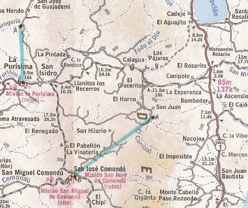
You are speaking of the one via Los Pajaros on the 2003 map, below?

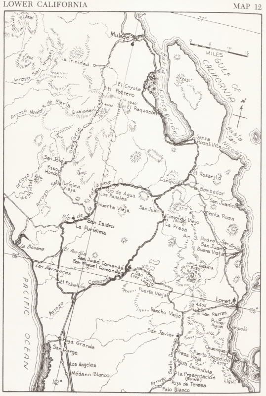
I think everyone uses the graded road... the other road will be a slower drive I would bet... We took it in 1966 as a short cut to Comondu and La Paz instead of the former route via Rancho Santa Rosalillita (at the bottom of Bahia Concepcion) and Rancho El Rosarito (near where the new graded road meets Hwy. 1).

2003 Map:

(the highlight line connects the two sites of the Comondu mission, 1708 and 1737 and the two La Purisima mission sites)

Here are the area roads as they were in the early 1960's:


[Edited on 4-2-2011 by David K]

TeamDonde - 4-2-2011 at 10:38 AM

Thx for the quick reply guys. The Los Pajaros is exactly what I was wondering about. Seems like it would save some mileage on the highway into Mulege. But sounds like everyone goes out the main road that comes out at the red 85m marked on the map.

Anyone try the Los Pajaros route lately? Maybe we can go that way on our dirt bikes and can send our truck out the main graded road.

Bob H - 4-2-2011 at 10:45 AM

Took that route about 14 years ago in my old 1990 F150. It was a whole lot of fun, but it took much longer than I thought and we ended up driving the last part of it in the dark. I stopped and turned my headlights off... and, man, it was pitch black out there!!!
We pulled into Mulege very hungry. Ate lots of great food and drank a couple of beers before retiring for the night.
Bob H

PS: David, your maps area always a treat!

[Edited on 4-2-2011 by Bob H]

TeamDonde - 4-2-2011 at 10:50 AM

If we venture that way I will be sure to post and update.

Thx All!