BajaNomad

From San Diego South to PuntaFinal 4-8-11

cabaja - 4-6-2011 at 02:12 PM

We are going south from San Diego By way of Mexicali and San Felipe to PuntaFinal on Friday AM !!

In case anyone wants to tag along.

www.cabaja.com

[Edited on 4-6-2011 by cabaja]

David K - 4-6-2011 at 03:24 PM

Please note or zero your mileage at the Puertecitos fork and then again where the pavement ends now. At last report it was about 26 miles south... (about 6 miles south of the big bridge that is just past El Huerfanito).

Thanks!

BajaBlanca - 4-6-2011 at 03:30 PM

Cabaja - put http:// in front of your www.cabaja address so that it forms a direct link !!

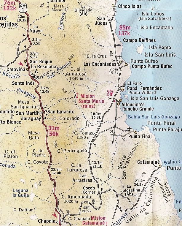
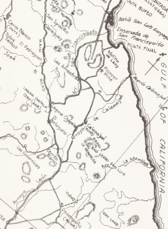
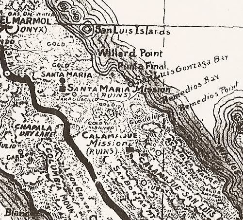
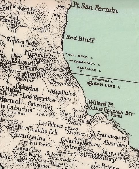
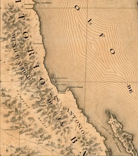
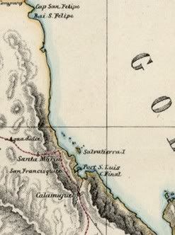
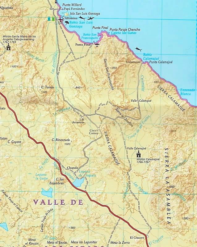
where is punta final ???

David K - 4-6-2011 at 03:46 PM

Quote:
Originally posted by BajaBlanca
Cabaja - put http:// in front of your www.cabaja address so that it forms a direct link !!

where is punta final ???


Still in the same place as always! ;)

2008:


2003:


1962:


1941:


1930:


1904:


1868:


Although, it was called Cabo Final on the oldest maps!

punta final

mcfez - 4-6-2011 at 07:33 PM

What a great place. We darn near bought the green house there. Make sure you go up and over the hill there....the dirt road may have a chain across it...just ask around and the caretaker at the old house ......he will take it down. Great snorkeling and fishing.

If you are camping.....'
Not sure if you'll find outhouses there......

Top off you fuel in Puertecitos. The last 20 or so miles of the highway is NOT paved. Rough....but doable with a slow pace.

Have fun!

[Edited on 4-7-2011 by mcfez]

Pointe_final.jpg - 26kB

Skipjack Joe - 4-6-2011 at 08:21 PM

There's an outhouse in that picture. Right next to Snoopy's ear. It only has 3 walls and faces the homes but is so distant that it's actually fairly private.

mcfez - 4-6-2011 at 08:43 PM

Never saw it!
Hey cabaja......check that out , will you, and let us know?


Now.....why only 3 walls :?: Short on the ol material budget?

bonanza bucko - 4-7-2011 at 06:55 AM

We drove in to Alfonsina's on Monday.

The pavement ends at mile 77 south of San Felipe. Then there are about 10 miles of good graded road and only 13 miles left of the old "road." The graded construction road is very good...they have graded the old "ScareCrow Draw" where you had to climb over sharp rocks about a foot high...nice to see that go bye bye.

The last 13 miles are a mess....the old washboard has been made about 200% worse by the Baja 1000 which dug holes the size of a VW about every 30 feet....swoopy do of a ride..can't go slow enough to keep the stuff in back from going airborn. The Mexicans billed SCORE for the road "damage" but, of course, don't grade the road...haven't since about 1999.

Be very careful driving anywhere on this road. The falling rock on the pavement through the old Tres Marias is sometimes extreme and if you come around a blind curve at 65 MPH (speed limit 110 KPH) you are gonna hit one and have a really bad day. Sometimes it's necessary to stop and move the rocks to get by..stay awake!

Also be careful about where the end of the pavement is...some guys came in here a day ago driving at night and went over the end and into some rebar....almost got killed....maximum dumb for driving in there at night but...???

As bad as it was we are gonna miss that old "road" when it's gone....good roads bring bad people. Think LA.

wessongroup - 4-7-2011 at 06:59 AM

Thanks for the report, and yes your correct... on the roads.....

David K - 4-7-2011 at 12:01 PM

Quote:
Originally posted by bonanza bucko
We drove in to Alfonsina's on Monday.

The pavement ends at mile 77 south of San Felipe. Then there are about 10 miles of good graded road and only 13 miles left of the old "road." The graded construction road is very good...they have graded the old "ScareCrow Draw" where you had to climb over sharp rocks about a foot high...nice to see that go bye bye.

The last 13 miles are a mess....the old washboard has been made about 200% worse by the Baja 1000 which dug holes the size of a VW about every 30 feet....swoopy do of a ride..can't go slow enough to keep the stuff in back from going airborn. The Mexicans billed SCORE for the road "damage" but, of course, don't grade the road...haven't since about 1999.

Be very careful driving anywhere on this road. The falling rock on the pavement through the old Tres Marias is sometimes extreme and if you come around a blind curve at 65 MPH (speed limit 110 KPH) you are gonna hit one and have a really bad day. Sometimes it's necessary to stop and move the rocks to get by..stay awake!

Also be careful about where the end of the pavement is...some guys came in here a day ago driving at night and went over the end and into some rebar....almost got killed....maximum dumb for driving in there at night but...???

As bad as it was we are gonna miss that old "road" when it's gone....good roads bring bad people. Think LA.


Did you note the mileage at the Puertecitos junction?
Where did you start with Mile 0 for San Felipe?

Was it:
1)Hwy. 5 traffic circle?
2)Pemex on south side of town where old road joins?
3)left turn off airport road (Km.0)?

Thank you.

Last July (2010) it ended 20 miles from the Puertecitos Jcn. at an unfinished bridge (just south of El Huerfanito). This was the point it had ended since March 2010. It was reported that the next 10 km. section was done (6 miles) since then.

It seems like the can build and pave 1 mile per month?

BajaBlanca - 4-7-2011 at 12:05 PM

the gorgeous locations in Mexico necer cease to astound me ... Punta Final looks sooooooooooooo beautiful.

bonanza bucko - 4-7-2011 at 12:53 PM

Mile Zero for us is the Pemex on the traffic circle in San Felipe. The Puertecitos Y junction is then mile 52 and the end of the pavement is mile 77..... well beyond the big bridge at Huerfanito that was the hold up for so long...the pavement goes about five miles south of that bridge. The graded, construction, road is good for another ten miles and then you have 13 miles of "That Road" to Alfonsina's turn off.
------------------------------------------------------------------------------------
BTW we didn't see any of the Chupacabras y Bandidos that have been waiting along "That Road" for Gringo touristas in Cadillacs...All of us locals know that the Bandidos live in the draws and canyons along the road waxing their mustachios and polishing their pistolas so they will be ready to stick up any Gringo in a Cadillac who stops to take a leak or toss out a beer can. The Chupucabras, of course, sneak out of the barancas after dark to suck the blood outa your goat and to make your little kids go to be early. But the Chupacabras don't like any Gringo in any Cadillac...not even in a Hummer, which is a Cadillac with a box body.

These poor things will be outa work when the entire road is done. Us locals are gonna have to retrain them to perform frights and mild mayhem on anybody from Buena Park with a camper full of rotten little kids who make it in here on a four day weekend.

David K - 4-7-2011 at 01:00 PM

Quote:
Originally posted by BajaBlanca
the gorgeous locations in Mexico necer cease to astound me ... Punta Final looks sooooooooooooo beautiful.


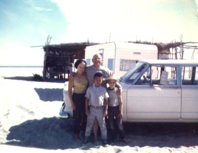
In 1983, on our way home from a Laguina Manuela fishing trip, my parents and I saw the new road leaving Laguna Chapala, and decided to go camp on Gonzaga Bay for the night... The new road went only to Puerto Calamajue that year, but we turned left near where Coco's Corner would later be established and took the original road to Gonzaga. In this case, we decided to check out Punta Final instead of going all the way to Alfonsina's. We found a gringo vacation community there, and drove down the beach just far enough to be out of anyone's front view.

It was one of the last times I got to take both my parents to Baja before I got married and my dad couldn't travel anymore.

This photo is in my web site in my Baja photo album section...


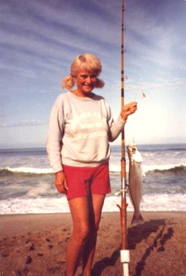
Coming home from Laguna Manuela, we made camp on the beach near Punta Final. My parents knew how to make camping fun as the champagne was always on ice!

David K - 4-7-2011 at 01:03 PM

Quote:
Originally posted by bonanza bucko
Mile Zero for us is the Pemex on the traffic circle in San Felipe. The Puertecitos Y junction is then mile 52 and the end of the pavement is mile 77..... well beyond the big bridge at Huerfanito that was the hold up for so long...the pavement goes about five miles south of that bridge. The graded, construction, road is good for another ten miles and then you have 13 miles of "That Road" to Alfonsina's turn off.
------------------------------------------------------------------------------------
BTW we didn't see any of the Chupacabras y Bandidos that have been waiting along "That Road" for Gringo touristas in Cadillacs...All of us locals know that the Bandidos live in the draws and canyons along the road waxing their mustachios and polishing their pistolas so they will be ready to stick up any Gringo in a Cadillac who stops to take a leak or toss out a beer can. The Chupucabras, of course, sneak out of the barancas after dark to suck the blood outa your goat and to make your little kids go to be early. But the Chupacabras don't like any Gringo in any Cadillac...not even in a Hummer, which is a Cadillac with a box body.

These poor things will be outa work when the entire road is done. Us locals are gonna have to retrain them to perform frights and mild mayhem on anybody from Buena Park with a camper full of rotten little kids who make it in here on a four day weekend.


Thanks for that... it all adds up perfectly now...

mcfez - 4-7-2011 at 04:29 PM

Quote:
Originally posted by David K
Quote:
Originally posted by BajaBlanca
the gorgeous locations in Mexico necer cease to astound me ... Punta Final looks sooooooooooooo beautiful.


In 1983, on our way home from a Laguina Manuela fishing trip, my parents and I saw the new road leaving Laguna Chapala, and decided to go camp on Gonzaga Bay for the night... The new road went only to Puerto Calamajue that year, but we turned left near where Coco's Corner would later be established and took the original road to Gonzaga. In this case, we decided to check out Punta Final instead of going all the way to Alfonsina's. We found a gringo vacation community there, and drove down the beach just far enough to be out of anyone's front view.

It was one of the last times I got to take both my parents to Baja before I got married and my dad couldn't travel anymore.

This photo is in my web site in my Baja photo album section...


Coming home from Laguna Manuela, we made camp on the beach near Punta Final. My parents knew how to make camping fun as the champagne was always on ice!


David....
This picture is so cool! Love it!

David K - 4-7-2011 at 04:49 PM

Thanks Deno... I wish we could turn back the clock to some wonderful times we had...

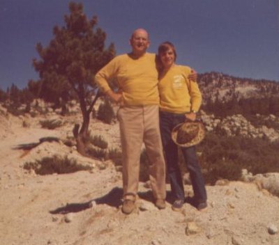
Here is a photo of my dad and I in Oct. 1972... I was 15 and we were driving to the observatory on the new road in the San Pedro Martir... We stayed at Mike's Sky Rancho and there were some Mexican 1000 (Baja 1000) racers pre-running the Mexicali to La Paz race.


Anyway, we got to the end of the road past the small observatories that were there, took a photo of the 8,000+ foot dropoff to Diablo Dry Lake and of Diablo Mountain and were chased away.

mcfez - 4-7-2011 at 07:15 PM

Quote:
Originally posted by David K
Thanks Deno... I wish we could turn back the clock to some wonderful times we had...

Here is a photo of my dad and I in Oct. 1972... I was 15 and we were driving to the observatory on the new road in the San Pedro Martir... We stayed at Mike's Sky Rancho and there were some Mexican 1000 (Baja 1000) racers pre-running the Mexicali to La Paz race.


Anyway, we got to the end of the road past the small observatories that were there, took a photo of the 8,000+ foot dropoff to Diablo Dry Lake and of Diablo Mountain and were chased away.


Let me tell you something David. Keep it to yourself here :)

This last picture. Pop holding son.
I dont see that much. Not in these days. Not in the old days. My Dad would die before holding us as such in the picture you have posted. Having said that...

I know for a fact that your Dad gave you 100% unconditional love. How do I know? I duplicate that picture of yours EVERY TIME I see my older kids. My young son Nicky gets hugged everyday :-)

You....a lucky man DavidK.

BajaBlanca - 4-8-2011 at 02:17 PM

both of the pics are priceless.

David K - 4-8-2011 at 06:25 PM

THanks a lot for those comments...

Here are some more of the man responsible for my addiction to Baja:

1966 at La Paz before bording the ferry to Mazatlan after 2 weeks driving the length of the peninsula by Jeep:


1967 at Nuevo Mazatlan (my school friend Shawn was with us)


1982 at Rancho Santa Ynez:


1983 near Laguna Manuela (Variety Beach):


In case you wondered who was taking the photos... mom:


Last photo is 'congratulations' after making it through Laguna Chapala dust bowl along an under construction Mex. 1 in July, 1973 (in a new 2WD station wagon as we thought the highway would be nearly done... it wasn't!)...

scan0016.jpg - 45kB

Aerial view of Punta Final

Stickers - 4-8-2011 at 10:49 PM

Here is a short video we shot flying over Punta Final many years ago.
You can see the dirt airstrip as we pass by and the "secret bay."

http://www.youtube.com/watch?v=u4r4O4CwuuI

BajaBlanca - 4-10-2011 at 10:00 AM

those pics are great ... no wonder you love Baja so much - in your blood from day one !! your dad must've been a super great guy. I so wish I had known about how fab Baja was before we moved here, I would have brought my kids ....

David K - 4-10-2011 at 10:03 AM

Thanks! I hope to see your place someday... We did drive through La Bocana after staying with Juan and Shari in Asuncion, back in 2007...