Attn: All Pilots --- I'm searching for aerial photographs. Date is irrelevant, but tell me anyway.
A very specific location on the Pacific coast, Baja Sur. I've tried multiple Google searches but figure this is THE site to post a help request. My
motives remain a secret right now. Winner gets a free day of panga fishing. Or free surf lessons at my super-secret sweet spot. THANKS in advance for
any and all info.
Location: Pacific Coast from beach to 2 Km inland
NORTH of La Paz
SOUTH of Ciudad Constitucion
The stretch between:
SOUTH of Conejo light house & surf point
NORTH of Punta Marquez surf point (at Ley Federal Agraria Dos
Sort of this area for Pilots & Navigators:
24° 00' N
110° 54' 30" W
For Boaters & Fishermen:
Due east 30 miles of the Luisitania Bank
[Edited on 2011-7-26 by bryanmckenzie]Curt63 - 7-26-2011 at 05:00 PM
Try Charles Chandler.
He has extensive aerial photos of Baja.bryanmckenzie - 7-26-2011 at 05:33 PM
That's "top secret" right now Natalie. More to come in the coming weeks. But suffice it to say that I think I've found the remnants of a "lost"
mission in the area.
Quote:
Originally posted by Natalie Ann
Curious.... waddaya plan to do with the photos?
nena
bryanmckenzie - 7-28-2011 at 02:26 PM
Oh, Kurt! I hate you. I have spent the better part of two days on his sites looking at Baja "eye candy." All I can say is WOW! This would be my ideal
"career" --- flying, Baja, photography, travel. Oh, yeah, and a small cooler of Pacificos; cans of course (they're lighter than bottles).
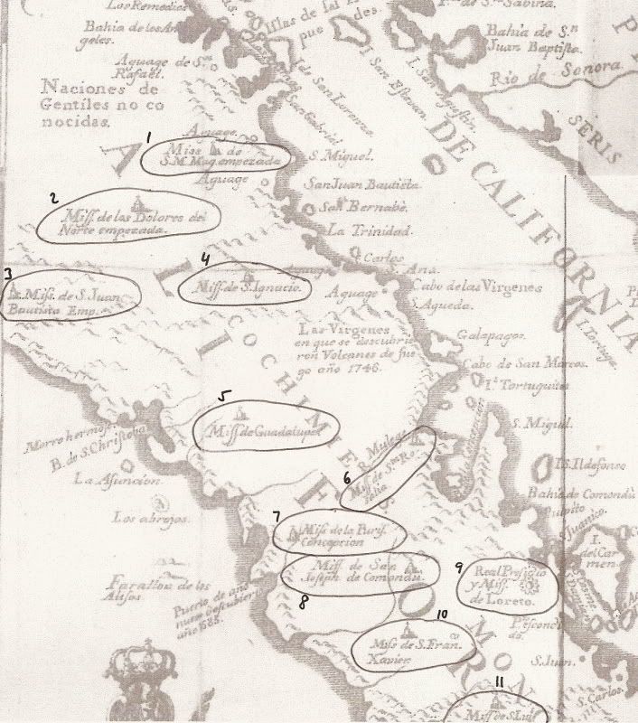
Bryan, there is (really) one 'lost' mission still to find (unless you still want to look more for Santa Isabel)!
That remaining lost mission was shown on the Jesuit's 1757 map as a mission 'started' in the Sierra Santa Clara mountains, north of Punta Abreojos
(west of San Ignacio)... It was named 'San Juan Bautista', but the legend has simply called it the Lost Santa Clara Mission.
The locals at Abreojos know of it, well!
It is #3, due west of San Ignacio.
#2 is Dolores del Norte, once believed to be a lost mission but later learned it was simply the proposed name that eneded up becoming Santa Gertrudis.
#1 is Santa Maria Magdalena, which Choral Pepper believed was the site they found in 1966, and we photographed in 2009 http://vivabaja.com/109
#4 is San Ignacio.bryanmckenzie - 7-30-2011 at 11:47 AM
Thanks David. Once again, you've piqued (sp?) my curiosity. But that Mision will have to wait for another day. And an exploration budget. I'd make
this a month-long adventure.
[Edited on 2011-7-30 by bryanmckenzie]David K - 7-30-2011 at 06:42 PM