BajaNomad

what's under the Sea of Cortez?

mulegemichael - 8-29-2011 at 08:37 AM

huh?

durrelllrobert - 8-29-2011 at 08:41 AM

Quote:
Originally posted by mulegemichael
huh?

SORRY> Pictures wont post so I'm removing this.

David K - 8-29-2011 at 10:54 AM

Quote:
Originally posted by durrelllrobert
Quote:
Originally posted by mulegemichael
huh?

SORRY> Pictures wont post so I'm removing this.


U2U or Email it to me if you want me to post it...?

sancho - 8-29-2011 at 11:30 AM

Read a item about, I believe it was Scripps Oceanography,
they sent a camera down in the region of LA Bay where
the Isles combine to funnel the Cortez flow during a
big tidal exchange creating a Venturi Effect.
Said they saw boulders the size of box cars being
moved on the bottom

durrelllrobert - 8-29-2011 at 11:56 AM

Quote:
Originally posted by durrelllrobert
Quote:
Originally posted by mulegemichael
huh?

SORRY> Pictures wont post so I'm removing this.

I think I got it this time.What's under the Sea of Cortez? In the 1960s the Soviet Union damed up all the rivers feeding the Aral Sea. Today it is dry and these pictures show what it looks like now:


[IMG]


Puckdrop - 8-29-2011 at 12:03 PM

I think I saw Noah's arc in one of those pics:lol::lol::lol:

Barry A. - 8-29-2011 at 05:26 PM

Looks like the Laguna Salada to me---------spanish galleons out there someplace, full of treasure for sure.

Someone should go for it, but not much fun looking in that waste land.

The Aral Sea situation is a true trajedy!!! It was HUGE, once upon a time in the very recent past.

David K - 8-29-2011 at 05:43 PM

Trying to make the connection to the thread title? The Aral Sea is a lake (or was)... The Sea of Cortez is an arm of the Pacific Ocean. Damming the Colorado River doesn't affect the water level...?

J.P. - 8-29-2011 at 05:51 PM

Thanks Bob REAL interesting post. Wonder what the bottom of lake Mead would look like

Barry A. - 8-29-2011 at 07:23 PM

Quote:
Originally posted by David K
Trying to make the connection to the thread title? The Aral Sea is a lake (or was)... The Sea of Cortez is an arm of the Pacific Ocean. Damming the Colorado River doesn't affect the water level...?


Well, yes and no. :biggrin:

I was just thinking that the pics of the dry Aral sea sorta look like the Laguna Salada, and that being the main connection.

But, the damming of the Colorado has a very real effect on the Laguna S. as it is the occasional flood waters from the Colorado River that backup behind the sand berm "natural dam" in the delta of the Colorado River causing the water to flow into the slightly lower elevations of the Laguna S.-------I have seen the water in the Laguna S. come and go over the many years in response to the Colorado river floods (which seldom happens anymore, granted.) To the best of my knowledge, the waters of the Pacific have not entered the Laguna S. within written Historic times, but yes it was an arm of the Sea of Cortez 1000's (millions?) of years ago as was the Imperial Valley, until the deposited sediments of the Colorado River eventually cut them both off from the Sea.

Man's attempted control over water has always fasinated me.

Barry

Barry A. - 8-29-2011 at 09:51 PM

Quote:
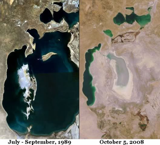
Originally posted by sancho
Read a item about, I believe it was Scripps Oceanography,
they sent a camera down in the region of LA Bay where
the Isles combine to funnel the Cortez flow during a
big tidal exchange creating a Venturi Effect.
Said they saw boulders the size of box cars being
moved on the bottom


Wow, that is incredible!!! I knew there was A LOT of water passing by the mid-drift of the SOC during tide changes, but "house size boulders" is truly amazing!! I would love to see that, even if just on a computer screen, or something.

Thanks for posting that tid-bit, Sancho.

Barry

wessongroup - 8-29-2011 at 10:04 PM

Cool thread .. thanks mulegemichael :):)

Von - 8-30-2011 at 06:38 PM

dirt and mud and some scallops lol~

Pablito1 - 8-31-2011 at 08:37 AM

In 1991 I flew over the Aral Sea on a real clear day. It was amazing to see how much this former "sea" has shrunk.

Regards, Pablito

durrelllrobert - 8-31-2011 at 10:21 AM

Quote:
Originally posted by David K
Trying to make the connection to the thread title? The Aral Sea is a lake (or was)... The Sea of Cortez is an arm of the Pacific Ocean. Damming the Colorado River doesn't affect the water level...?

I was just wondering how many similar shipwrecks were under the SoC:?:

jbcoug - 8-31-2011 at 11:05 AM

Keep in mind that almost everything in the pictures here was NOT on the bottom of the Aral Sea. These ships were on the sea until the sea disappeared from under them. I've seen pictures with rows of these derelicts sitting in partially dug channels. They only got partially dug because the water disappered from under them before the channel could reach another large body of water. Pretty spooky! Notice, they are all sitting upright.

John

[Edited on 8-31-2011 by jbcoug]

bacquito - 8-31-2011 at 08:03 PM

Quote:
Originally posted by Barry A.
Looks like the Laguna Salada to me---------spanish galleons out there someplace, full of treasure for sure.

S


Cussler, Inca Gold! Good book.

David K - 8-31-2011 at 11:03 PM

Quote:
Originally posted by durrelllrobert
Quote:
Originally posted by David K
Trying to make the connection to the thread title? The Aral Sea is a lake (or was)... The Sea of Cortez is an arm of the Pacific Ocean. Damming the Colorado River doesn't affect the water level...?

I was just wondering how many similar shipwrecks were under the SoC:?:


OK... thanks for explaining what you were thinking about! Get Ed Vernon's book 'A Maritime History of Baja California' and Walt Peterson's 'The Baja Adventure Book' for details on shipwrecks.

other diminishing salt lakes

Mulegena - 9-4-2011 at 08:43 AM

Protestors arrested in Iran re: Lake Orumiyeh which has lost over half its volume in 20 years due to dams and drought. The protest came about because the parliament refused to implement a rescue plan for the lake which borders Turkey and Iraq.

http://www.bbc.co.uk/news/world-middle-east-14780708

Salton sink canal

Dave - 9-6-2011 at 01:11 PM

There's been talk over the years about a canal system all the way up to a port near Indio which I think is pretty much downhill. It would be cool but there's no money now and probably never will be.

David K - 9-6-2011 at 07:08 PM

Quote:
Originally posted by Dave
There's been talk over the years about a canal system all the way up to a port near Indio which I think is pretty much downhill. It would be cool but there's no money now and probably never will be.


Indio is north of, and higher up than the Salton Sea (sink)... the canal that was once proposed was to go south to the Sea of Cortez. The idea was to flush the Salton Sea and return its salt level to that which is closer to the ocean (and flush out the selenium and other agri-cchemicals). Calexico and Mexicali (which are between the Saton Sea and the Sea of Cortez) are at sea level, and thus also higher than the Salton Sea (which I think is about 240 feet below sea level).

Here's part of what is under there

vgabndo - 9-6-2011 at 07:53 PM

High tech sonar mapping off the coast of Mulege'

http://www.ceoe.udel.edu/deepsea/dailynews/neatstuff/day/21....

durrelllrobert - 9-7-2011 at 11:42 AM

Quote:
Originally posted by vgabndo
High tech sonar mapping off the coast of Mulege'

http://www.ceoe.udel.edu/deepsea/dailynews/neatstuff/day/21....

Wow! 2,000 meter deep throughs.

David K - 9-7-2011 at 11:50 AM

Quote:
Originally posted by vgabndo
High tech sonar mapping off the coast of Mulege'

http://www.ceoe.udel.edu/deepsea/dailynews/neatstuff/day/21....


Cool link... this was in there:

Extreme 2000 scientists will dive to depths of about 1.5 miles in the Guaymas Basin in the Sea of Cortés. This area of the seafloor features unique hydrothermal vent sites, where there are high levels of petroleum (oil). There's evidence that some bacteria at the Guaymas vents are able to degrade this oil into non-toxic or less toxic compounds (a process called biodegradation).


Is Pemex reading this?

vgabndo - 9-7-2011 at 02:48 PM

Thanks David, I found it interesting that this great mapping was done on the "flip side" of the major expedition. They were primarily deploying the Alvin deep submersible, and did the mapping at night while they were cruising and charging Alvins batteries!

This tectonic rift extending past the mouth of the gulf is getting a lot of attention as it appears to be getting warmer. (If I have properly interpreted the science.) There must be hundreds of seismometers down there.

Barry A. - 9-7-2011 at 03:52 PM

Quote:
Originally posted by David K
Quote:
Originally posted by Dave
There's been talk over the years about a canal system all the way up to a port near Indio which I think is pretty much downhill. It would be cool but there's no money now and probably never will be.


Indio is north of, and higher up than the Salton Sea (sink)... the canal that was once proposed was to go south to the Sea of Cortez. The idea was to flush the Salton Sea and return its salt level to that which is closer to the ocean (and flush out the selenium and other agri-cchemicals). Calexico and Mexicali (which are between the Saton Sea and the Sea of Cortez) are at sea level, and thus also higher than the Salton Sea (which I think is about 240 feet below sea level).


Just to be picky--------My understanding, David, is that the Salton Sea bottom is about 275 feet below sea level, slighly higher than "Bad Water" in Death Valley at 282 feet below sea level. The surface of the Salton Sea is probably about the 240 feet below SL that you state.

I believe that the highest elevation between the Salton Sea (surface water level) and the SOC at 'sea level' is only 30 feet above Sea Level, but there would be a LOT of digging as there is a lot of earth between the Salton Sea and the SOC. Not practical, as I see it.

Barry

Barry

[Edited on 9-8-2011 by Barry A.]

Pompano - 9-7-2011 at 04:45 PM

4TH JASON PROJECT..TUBE WORMS OF THE SEA OF CORTEZ...1993.

REMEMBER THAT, MULEGE?

GOOD TIMES WITH THE RESEARCH MEMBERS ...'FLYING' THE LITTLE GUY...'ARGO'..TUBE WORMS FEEDING NEAR VOLCANIC VENTS 7,000 FT DOWN.

AN INTERACTIVE EXPERIENCE WITH HUNDREDS OF THOUSANDS OF STUDENTS WORLD-WIDE.


A NEW WAY TO STUDY AND LEARN ABOUT.....LIFE.

THE ROMANTIC LIGHTS AT SEA NIGHTTIMES FROM EL PATRON'S CANTINA..
A SAUCY NAVY LT. NAMED 'C'....BE STILL, MY HEART...AND HELP ME KEEP MY MOUTH SHUT.. ;)

rocks, mud & a few fish

bajadave1 - 9-8-2011 at 07:12 AM


Barry A. - 9-8-2011 at 07:59 AM

Quote:
"ROCKS, MUD, AND A FEW FISH"---Originally posted by bajadave1


You OBVIOUSLY are NOT a Geographer!!! :P

Barry

I'm a realist

bajadave1 - 9-9-2011 at 06:19 AM

:P:P:P
Dave

Skipjack Joe - 9-9-2011 at 06:48 AM

That's like the disappointed husband after the Machu Pichu trip:

"All there was was ruins everywhere"