BajaNomad

MISSIONS over the years 1700 to 1840 on maps

David K - 12-13-2011 at 01:26 PM

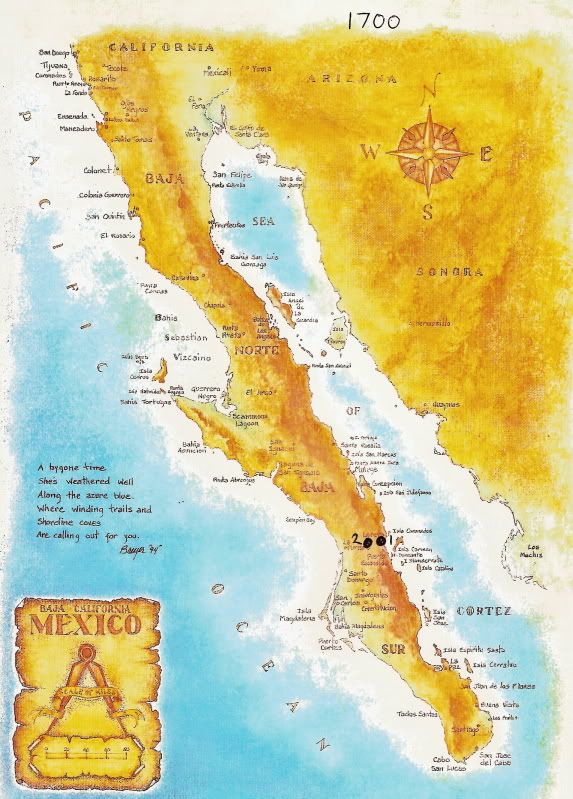
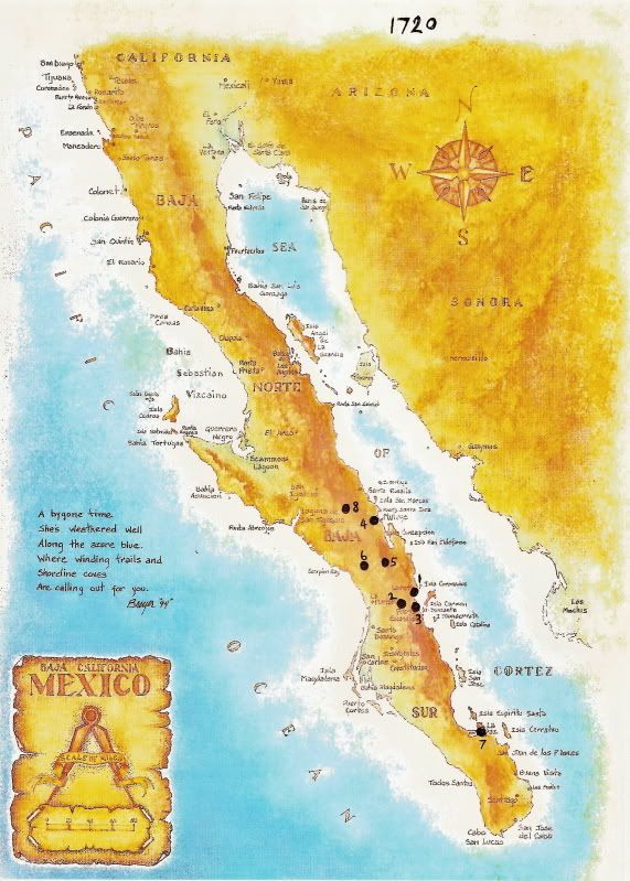
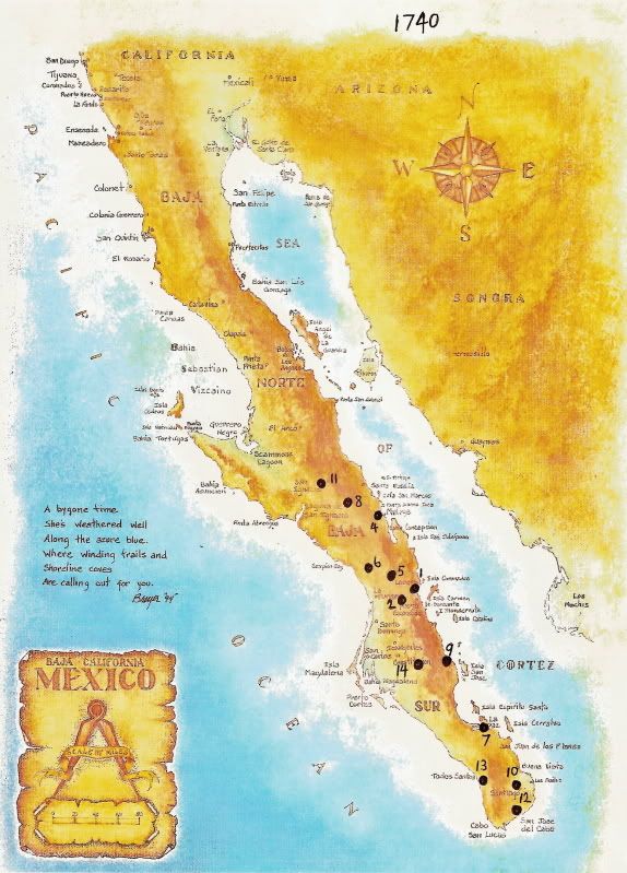
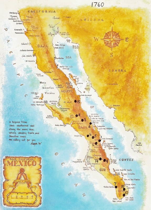
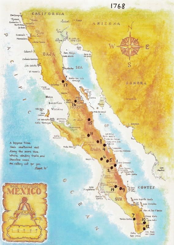
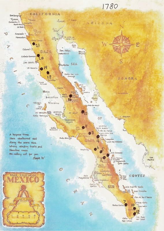
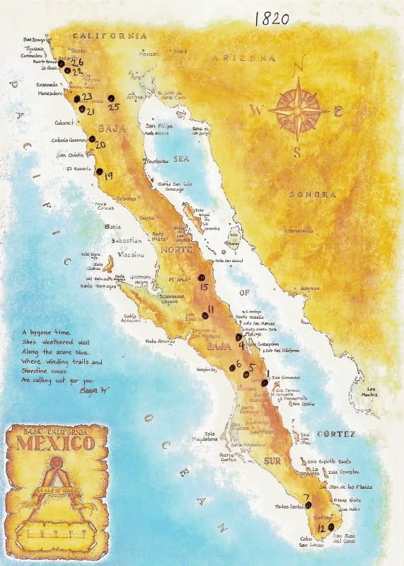
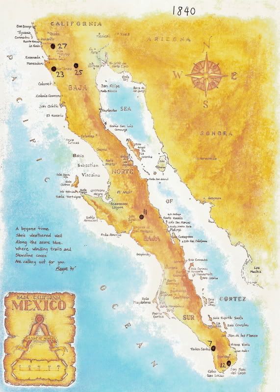
Seeing the build up, then decline of missions on the peninsula is easy with the use of maps showing the mission locations.

I made a location map for every 20 years starting in 1700 and ending in 1840, the last year for the remaining missions except Santo Tomas (1849).

In the captions, I will list missions that moved or were removed during the 20 year periods.


1700 2 missions


1) Nuestra Seņora de Loreto Concho 1697-1829

2) San Francisco Javier de Biaundo 1699-1817 (moved 5 miles south in 1710)
---------------------------------------------------------------------------------------

1720 8 missions

San Javier mission moved.

1) Nuestra Seņora de Loreto Concho 1697-1829

2) San Francisco Javier de Biaundo 1699-1817 (moved 5 miles south in 1710)

3) San Juan Bautista de Ligui/ Malibat 1705-1721

4) Santa Rosalia de Mulege 1705-1828

5) San Jose de Comondu 1708-1827 (moved 22 miles south in 1736)

6) La Purisima Concepcion de Cadegomo 1720-1822 (moved 10 miles south in 1735)

7a) Nuestra Seņora del Pilar de la Paz Airapi 1720-1748 (moved to Todos Santos in 1748)

8) Nuestra Seņora de Guadalupe de Huasinapi 1720-1795
-----------------------------------------------------------------------------------------

1740 13 missions

Ligui mission removed, and re-established as Dolores. Comondu mission moved. Purisima mission moved. Santiago mission moved. San Jose del Cabo mission moved.

1) Nuestra Seņora de Loreto Concho 1697-1829

2) San Francisco Javier de Biaundo 1699-1817 (moved 5 miles south in 1710)

4) Santa Rosalia de Mulege 1705-1828

5) San Jose de Comondu 1708-1827 (moved 22 miles south in 1736)

6) La Purisima Concepcion de Cadegomo 1720-1822 (moved 10 miles south in 1735)

7a) Nuestra Seņora del Pilar de la Paz Airapi 1720-1748 (moved to Todos Santos in 1748)

8) Nuestra Seņora de Guadalupe de Huasinapi 1720-1795

9a) Nuestra Seņora de los Dolores Apate 1721-1741 (moved to La Pasion in 1741)

10) Santiago el Apostal Aiņini 1724-1795 (moved 2 miles south in 1734)

11) Nuestro Seņor San Ignacio Kadakaaman 1728-1840

12) San Jose del Cabo Aņuiti 1730-1840 (moved 5 miles north, then back, then 1 mile north)

13) Santa Rosa de las Palmas (Todos Santos) 1733-1748 (absorbed by moved La Paz mission in 1748)

14) San Luis Gonzaga Chiriyaqui 1737-1768
---------------------------------------------------------------------------------------

1760 12 missions

La Paz mission moved. Santa Rosa mission removed. Dolores mission moved.

1) Nuestra Seņora de Loreto Concho 1697-1829

2) San Francisco Javier de Biaundo 1699-1817 (moved 5 miles south in 1710)

4) Santa Rosalia de Mulege 1705-1828

5) San Jose de Comondu 1708-1827 (moved 22 miles south in 1736)

6) La Purisima Concepcion de Cadegomo 1720-1822 (moved 10 miles south in 1735)

7b) Nuestra Seņora del Pilar de la Paz (Todos Santos) 1748-1840

8) Nuestra Seņora de Guadalupe de Huasinapi 1720-1795

9b) Nuestra Seņora de los Dolores Chilla (La Pasion) 1741-1768

10) Santiago el Apostal Aiņini 1724-1795 (moved 2 miles south in 1734)

11) Nuestro Seņor San Ignacio Kadakaaman 1728-1840

12*) San Jose del Cabo Aņuiti was reduced to visita status from 1748-1768, under the mission of Santiago.

14) San Luis Gonzaga Chiriyaqui 1737-1768

15) Santa Gertrudis de Cadacaman 1751-1822
-----------------------------------------------------------------------------------------


A big event year for California mission history was the 1767 royal order to replace the Jesuits in California with the Franciscans.

1767/1768 15 missions


In 1762, San Borja was founded and then four years later, the next mission north was founded at Calamajue. Just a few months were spent there before the bad water forced a move 30 miles to the final site of the 17th and final Jesuit mission named Santa Maria de los Angeles.

1) Nuestra Seņora de Loreto Concho 1697-1829

2) San Francisco Javier de Biaundo 1699-1817 (moved 5 miles south in 1710)

4) Santa Rosalia de Mulege 1705-1828

5) San Jose de Comondu 1708-1827 (moved 22 miles south in 1736)

6) La Purisima Concepcion de Cadegomo 1720-1822 (moved 10 miles south in 1735)

7b) Nuestra Seņora del Pilar de la Paz (Todos Santos) 1748-1840

8) Nuestra Seņora de Guadalupe de Huasinapi 1720-1795

9b) Nuestra Seņora de los Dolores Chilla (La Pasion) 1741-1768

10) Santiago el Apostal Aiņini 1724-1795 (moved 2 miles south in 1734)

11) Nuestro Seņor San Ignacio Kadakaaman 1728-1840

*12) San Jose del Cabo Aņuiti 1730-1840 (moved 5 miles north, then back, then 1 mile north)

14) San Luis Gonzaga Chiriyaqui 1737-1768

15) Santa Gertrudis de Cadacaman 1751-1822

16) San Francisco de Borja Adac 1762-1818

17b) Santa Maria de los Angeles 1767-1769

*San Jose del Cabo was a visita of Santiago from 1748 to 1768

In their 71 years on the peninsula, the Jesuits founded 17 missions and only closed Ligui, Santa Rosa and San Jose del Cabo). Ligui was a failed site, but Santa Rosa was prosperous. The La Paz mission being the oldest of the two absorbed Santa Rosa when it moved to there in 1748. The location was generally called Todos Santos, the original name when it was a visita of La Paz before becoming a seperate mission of Santa Rosa. San Jose del Cabo was reduced from mission to visita in 1748 to 1768. For financial resons it too was called abandoned, so funds could be directed to establish Santa Gertrudis in 1751.

The Jesuits were removed by force early in 1768. The Franciscans, under orders by the governor-general, closed Los Dolores and San Luis Gonzaga, moving the remaining Indians to Todos Santos. San Jose del Cabo was returned to full mission status in 1768.
-------------------------------------------------------------------------------------------

1780 16 missions

Jesuits removed from California in 1768 after establishing the 17th mission at Calamajue in 1766 and then moving it to Santa Maria in 1767. Franciscans took over missions and removed Santa Maria in 1769. Dolores and San Luis Gonzaga were also removed by the governor general. Dominicans took over Baja California missions in 1773.

1) Nuestra Seņora de Loreto Concho 1697-1829

2) San Francisco Javier de Biaundo 1699-1817 (moved 5 miles south in 1710)

4) Santa Rosalia de Mulege 1705-1828

5) San Jose de Comondu 1708-1827 (moved 22 miles south in 1736)

6) La Purisima Concepcion de Cadegomo 1720-1822 (moved 10 miles south in 1735)

7b) Nuestra Seņora del Pilar de la Paz (Todos Santos) 1748-1840

8) Nuestra Seņora de Guadalupe de Huasinapi 1720-1795

10) Santiago el Apostal Aiņini 1724-1795 (moved 2 miles south in 1734)

11) Nuestro Seņor San Ignacio Kadakaaman 1728-1840

12) San Jose del Cabo Aņuiti 1730-1840 (moved 5 miles north, then back, then 1 mile north)

15) Santa Gertrudis de Cadacaman 1751-1822

16) San Francisco de Borja Adac 1762-1818

18) San Fernando Velicata 1769-1818

19) Nuestra Seņora del Rosario Viņaraco 1774-1832 (Moved 2 miles west in 1802)

20) Santo Domingo 1775-1839 (Moved 2 miles east in 1793)

21) San Vicente Ferrer 1780-1833
-------------------------------------------------------------------------------------

1800 18 missions

Guadalupe removed. Santiago removed.

1) Nuestra Seņora de Loreto Concho 1697-1829

2) San Francisco Javier de Biaundo 1699-1817 (moved 5 miles south in 1710)

4) Santa Rosalia de Mulege 1705-1828

5) San Jose de Comondu 1708-1827 (moved 22 miles south in 1736)

6) La Purisima Concepcion de Cadegomo 1720-1822 (moved 10 miles south in 1735)

7b) Nuestra Seņora del Pilar de la Paz (Todos Santos) 1748-1840

11) Nuestro Seņor San Ignacio Kadakaaman 1728-1840

12) San Jose del Cabo Aņuiti 1730-1840 (moved 5 miles north, then back, then 1 mile north)

15) Santa Gertrudis de Cadacaman 1751-1822

16) San Francisco de Borja Adac 1762-1818

18) San Fernando Velicata 1769-1818

19) Nuestra Seņora del Rosario Viņaraco 1774-1832 (Moved 2 miles west in 1802)

20) Santo Domingo 1775-1839 (Moved 2 miles east in 1793)

21) San Vicente Ferrer 1780-1833

22) San Miguel Arcangel 1787-1834 (moved 7 miles west in 1788)

23) Santo Tomas de Aquino 1791-1849 (moved 1 mile northeast in 1794, and 2 miles east in 1799)

24) San Pedro Martir de Verona 1794-1806 (moved 7 miles south and nearly 2,000' lower in elevation, after 3 months)

25) Santa Catalina Virgen y Martir 1797-1840
------------------------------------------------------------------------------------------

1820 15 missions

Mexico declared its independence from Spain in 1810. Over the next several years during the war, supplies to the missions were greatly reduced.
San Javier removed. San Borja removed. San Fernando removed. San Pedro Martir removed.

1) Nuestra Seņora de Loreto Concho 1697-1829

4) Santa Rosalia de Mulege 1705-1828

5) San Jose de Comondu 1708-1827 (moved 22 miles south in 1736)

6) La Purisima Concepcion de Cadegomo 1720-1822 (moved 10 miles south in 1735)

7b) Nuestra Seņora del Pilar de la Paz (Todos Santos) 1748-1840

11) Nuestro Seņor San Ignacio Kadakaaman 1728-1840

12) San Jose del Cabo Aņuiti 1730-1840 (moved 5 miles north, then back, then 1 mile north)

15) Santa Gertrudis de Cadacaman 1751-1822

19) Nuestra Seņora del Rosario Viņaraco 1774-1832 (Moved 2 miles west in 1802)

20) Santo Domingo 1775-1839 (Moved 2 miles east in 1793)

21) San Vicente Ferrer 1780-1833

22) San Miguel Arcangel 1787-1834 (moved 7 miles west in 1788)

23) Santo Tomas de Aquino 1791-1849 (moved 1 mile northeast in 1794, and 2 miles east in 1799)

25) Santa Catalina Virgen y Martir 1797-1840

26) El Descanso 1817-1834 (Also called 'San Miguel Nuevo', moved 1/2 mile north in 1830)
-----------------------------------------------------------------------------------------

1840 6 missions

The final year of operations for all the remaining Baja missions, except Santo Tomas (1849).

7b) Nuestra Seņora del Pilar de la Paz (Todos Santos) 1748-1840

11) Nuestro Seņor San Ignacio Kadakaaman 1728-1840

12) San Jose del Cabo Aņuiti 1730-1840 (moved 5 miles north, then back, then 1 mile north

23) Santo Tomas de Aquino 1791-1849 (moved 1 mile northeast in 1794, and 2 miles east in 1799)

25) Santa Catalina Virgen y Martir 1797-1840

27) Nuestra Seņora de Guadalupe 1834-1840
--------------------------------------------------------------------------------------


The Jesuits had 15 missions in operation at the time of their being removed. Only the missions at Ligui and La Paz were abandoned, but both were relocated (Dolores and Todos Santos). The mission already at Todos Santos (Santa Rosa) became part of the moved La Paz mission.

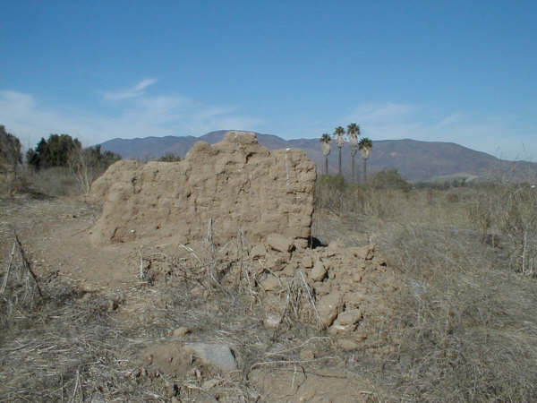
The Dominicans completed the started stone mission church at San Ignacio and built the stone churches at Santa Gertrudis and San Borja. All the mission buildings north of San Borja were made of adobe, and have fallen into ruin or nearly vanished from the elements.

For more details on the 27 Baja missions, as well as photos of most sites: http://vivabaja.com/bajamissions


[Edited on 5-16-2012 by David K]

Mexitron - 12-13-2011 at 02:19 PM

Nice time-lapse David! Good metaphor for the lifetimes of empires.....

David K - 12-13-2011 at 04:52 PM

Quote:
Originally posted by Mexitron
Nice time-lapse David! Good metaphor for the lifetimes of empires.....


Thanks Steve,

I wanted to make a visual display of the population centers on the peninsula founded by Europeans. The sites of 1820 have remained population centers today. Santa Gertrudis being the smallest, followed by Santa Catalina (re-named Santa Catarina by the Mexicans).

I welcome comments or corrections...

David

drpsp71 - 12-13-2011 at 11:09 PM

David, Your history of the history is lovely and fascinating, not least for the love of the hard work! Thank you. Penny

Ateo - 12-14-2011 at 08:48 AM

Interesting. My daughter is doing her mission project right now. I'll show her this.

David K - 12-14-2011 at 09:18 AM

Quote:
Originally posted by ateo
Interesting. My daughter is doing her mission project right now. I'll show her this.


Do show her the mission web page that I have worked on for some time, and includes many photos from Nomads such as Jack Swords... http://vivabaja.com/bajamissions

The California mission chain started in Baja, yet the California schools don't put much or any effort to teach this. San Diego was the 19th California mission, not the first! :light:

David K - 12-16-2011 at 02:17 PM

Three missions were closed during the Jesuit time on the peninsula, Ligui (Malibat), San Jose del Cabo, and Santa Rosa (Todos Santos).

Ligui was closed, but the mission population was moved to a new mission of Los Dolores using new funds, thus a new name. Santa Rosa didn't fail, the older mission at La Paz simply absorbed it when it moved from the Bay of La Paz to 'Todos Santos' (which was originally a visita of La Paz before becoming a seperate mission of 'Santa Rosa de las Palmas'. San Jose del Cabo was reduced from mission to visita status in 1748. The Franciscans would return it to mission status in 1768.

[Edited on 4-13-2012 by David K]

David K - 12-26-2011 at 06:33 PM

A mission was like a business, an organization, a corporation... not just the church building. However, the church for the mission was the largest structure and the best built... designed to impress the locals!

MISSIONS that operated over 100 years

David K - 12-28-2011 at 10:07 AM

Interesting is that the first California mission of Loreto was also the longest operating mission....

The 7 Longest Operating Missions in Baja California (over 100 years):

1) LORETO, 132 years (1697-1829)

2) SANTA ROSALIA DE MULEGE, 123 years (1705-1828)

3) PILAR DE LA PAZ/TODOS SANTOS, 120 years (1720-1748 then moved to Todos Santos from 1748-1840)*

4) COMONDU, 119 years (1708-1827)

5) SAN JAVIER, 118 years (1699-1817)

6) SAN IGNACIO, 112 years (1728-1840)

7) LA PURISIMA, 102 years (1720-1822)

* The mission of Santa Rosa de las Palmas was at Todos Santos for 15 years from 1733 to 1748, when the senior mission of Pilar de la Paz moved to there.

Before 1733, Todos Santos was a visita of the La Paz mission. The original name ('Todos Santos') was generally how the La Paz mission was called after 1748.

San Jose del Cabo (1730-1840) was not a mission for 20 years of its life (1748-1768) when it was reduced to being a visita of Santiago. Thus being a mission for 90 vs. 110 years.

[Edited on 4-13-2012 by David K]

Ateo - 12-28-2011 at 10:11 PM

My daughter just finished her California missions report. Wish she could've done it on Baja missions.

David K - 12-29-2011 at 09:27 AM

Quote:
Originally posted by ateo
My daughter just finished her California missions report. Wish she could've done it on Baja missions.


Yes, then she would have a unique report... the FIRST 18 California missions were on the peninsula (which was the first 'California')... We in the U.S. part are in Alta California. Yup, California and Alta California were the names originally. Funny how things turned around!

The San Diego mission was the 19th California mission! :lol:

Someday, I hope to see the mission kits for the Baja missions... at least the stone ones that remain standing today: San Borja, Santa Gertrudis, San Ignacio, Santa Rosalia de Mulege, Loreto, San Javier, & San Luis Gonzaga.

The Shortest Operating Missions

David K - 1-11-2012 at 12:48 PM

Above, I listed 7 missions that operated over 100 years. Now, here are 6 missions that operated less than 20 years:

1) SANTA MARIA (2 locations): 3 years (1766-1769)

2) GUADALUPE (del Norte): 6 years (1834-1840)

3) SAN PEDRO MARTIR (2 locations): 12 years (1794-1806)

4) SANTA ROSA DE LAS PALMAS: 15 years (1733-1748)

5) LIGUI/MALIBAT: 16 years (1705-1721)

6) EL DESCANSO (2 locations): 17 years (1817-1834)

[Edited on 4-13-2012 by David K]

Jack Swords - 1-11-2012 at 01:24 PM

Nice perspective, David. Certainly shows the frailty of the human condition. Thanks.

David K - 1-12-2012 at 02:29 PM

So Jack, any new discoveries of mission visita sites? Did you ever find anything at San Hilario, 100 km. north from La Paz (Jesuit mission gardens)?

Jack Swords - 1-13-2012 at 08:50 AM

San Hilario was a bust. Some ranches, no one knew anything. No evidence of historical importance. Hiked up to Angel de la Guarda yesterday and enjoyed seeing again the old ruins. Guava trees had no fruit, but lots of water and frogs croaking. Thinking of going back to La Pasion and poking around there. Let you know.

David K - 1-13-2012 at 11:53 AM

Quote:
Originally posted by Jack Swords
San Hilario was a bust. Some ranches, no one knew anything. No evidence of historical importance. Hiked up to Angel de la Guarda yesterday and enjoyed seeing again the old ruins. Guava trees had no fruit, but lots of water and frogs croaking. Thinking of going back to La Pasion and poking around there. Let you know.


Sounds good.

Jack Swords - 2-26-2012 at 12:03 PM

Just got back from BCS...lots of off road exploring. New Ocio hacienda, Gonzaga is the same, but with street lights. La Presa rancho is fenced off and developed into hotel (nobody there, duh!), La Pasion is completely destroyed and covered with a goat ranch (didn't have far to go, sadly it was never protected) Roads confusing as usual so getting a GPS "puck" receiver to integrate with our netbook using Google Earth and maps. Ranchers and folks living in the outback are the greatest.

David K - 2-26-2012 at 12:12 PM

Quote:
Originally posted by Jack Swords
Just got back from BCS...lots of off road exploring. New Ocio hacienda, Gonzaga is the same, but with street lights. La Presa rancho is fenced off and developed into hotel (nobody there, duh!), La Pasion is completely destroyed and covered with a goat ranch (didn't have far to go, sadly it was never protected) Roads confusing as usual so getting a GPS "puck" receiver to integrate with our netbook using Google Earth and maps. Ranchers and folks living in the outback are the greatest.


Glad you could photograph La Pasion before it was covered up/ destroyed! It joins Ligui, La Paz, and perhaps Santiago, San Jose del Cabo, and Todos Santos as being missions whose original Spanish foundations are gone...?

In the north, Santo Tomas (all three locations) are nearly gone.

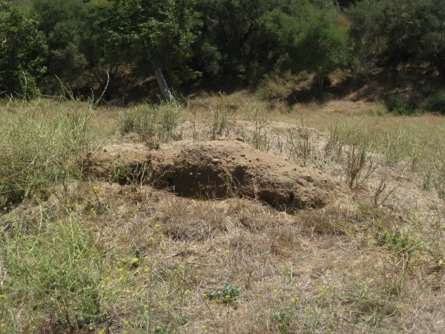
Here is the first site, July 2011:


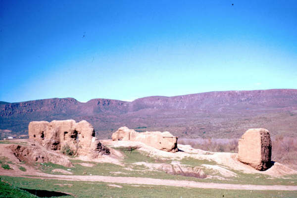
In 1977, the same site:


David K - 4-13-2012 at 12:52 AM

Just did some editing on the map lists... details on San Jose del Cabo... From 1748 to 1768 it was reduced from mission status to being just a visita of the Santiago mission. The Jesuits called it 'abandoned' in 1748 so funds could be used for founding a new mission to the north, Santa Gertrudis, in 1751. That was the wishes of the benefactor, who also provided the new mission's name, as it was planned to be called 'Dolores del Norte'.

thebajarunner - 4-13-2012 at 08:47 AM

We spent some time at San Borja last week,
it is so dramatic to reflect on what life must have been like 200 years ago in such primitive settings.
Also, the tremendous, and sad, drop in the indigenous population from the time of first establishment of the missions on into the next few decades.
Great report as always, my friend

D

David K - 4-13-2012 at 09:15 AM

Gracias B'Runner!

The 27 missions in Baja and their many visitas are a grand source for exploration, wonder, photography, reflection and so much more.

If we can keep the eyes open to this huge part of Baja's history and mystery, it could so benefit today's Baja population... If only they would stop destroying this window to the past!

It is one thing to lose a mission to nature, as in the case of Ligui. It is another to lose one to indifference or something else, as in the case of the farmer who plows over as site, or the government that bulldozes one to build a school on top of it... What does that teach?

thebajarunner - 4-13-2012 at 04:24 PM

Your photos of the Santo Tomas decline bring back lots of memories

At least, in some sites, like San Borja, they have built covering metal canopies over the ruins to give some semblance of preservation.

We could only hope for a better way to memorialize the past.

I seem to remember similar decay of the ruins in La Mision.

David K - 4-13-2012 at 09:37 PM

Quote:
Originally posted by thebajarunner

I seem to remember similar decay of the ruins in La Mision.


1949:


McDonald Photo

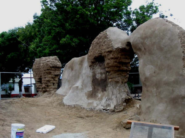
2003:


Jack Swords Photos

1926 plan by P. Meigs:


David K - 4-14-2012 at 11:39 AM

The final site of Santo Tomas... (1799-1849)...


In 1926


In 1975


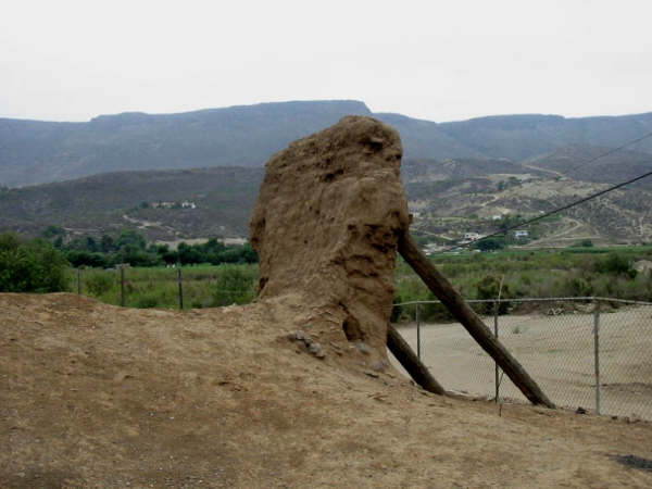
In 2005

This is just north of the El Palomar campground, east side of Mex. 1, as you enter town. The tall palms are a landmark seen from the highway.

See them disappear...

David K - 4-14-2012 at 11:50 AM

Santo Domingo is 5 easy graded dirt miles east of Hwy. 1, just north of the long bridge before Colonia V. Guerrero...

The final site for the mission, 1793-1839

1880:


1926:


1949:


1954:


2003:


2005:


Mexitron - 4-14-2012 at 03:02 PM

Cool pics, thanks David! BTW have you been back to the visita area out by R. El Metate recently to see what's become of the plowed field?

David K - 4-14-2012 at 07:36 PM

No... haven't been there since the farmer destroyed the mission visita church from 230 years ago.

BajaRat - 4-15-2012 at 11:08 AM

David,
Any site or thread discussing GPS puck / Google map setup and operation.
Thanks, BajaRat

David K - 4-15-2012 at 11:11 AM

Quote:
Originally posted by BajaRat
David,
Any site or thread discussing GPS puck / Google map setup and operation.
Thanks, BajaRat


Help me please... what is GPS puck ? On my Baja Missions pages I have GPS waypoints and Google Earth images above the mission sites... HERE: http://vivabaja.com/missions4/

[Edited on 4-15-2012 by David K]

BajaRat - 4-15-2012 at 11:20 AM

David,
It is a sat. antenna you plug in to your computer to plot and place you on a Google map.

David K - 4-15-2012 at 11:28 AM

Quote:
Originally posted by BajaRat
David,
It is a sat. antenna you plug in to your computer to plot and place you on a Google map.


Sounds like I need one of those... if I ever get a lap top!:light:

I would try the Google Earth forums for discussion on that set up... Unless some Nomads see this here, who have it.

BajaRat - 4-15-2012 at 11:35 AM

I'm wondering if a tablet would have the same capability, less space, energy, ease of handling.

Jack Swords - 4-15-2012 at 01:19 PM

http://www.amazon.com/GlobalSat-BU-353-Waterproof-USB-Receiv...

Have been using this GPS and my netbook in the Mojave Desert. It is necessary to cache an intended area in Google Earth before using it in the area. It works well just with GE, but better with Earthbridge software (free). It will leave a track (both GE and EB) that you can review later. I plan on using it in the area between La Paz and Constitucion and the Sea of Cortez. It also will work with the TOPO products (which recently came out with a TOPO CD of Baja). There is also a Bluetooth version (the other is USB) that will work with Ipad, Touch, netbooks, etc. as long as it has Bluetooth. This version is about $100, but is wireless. The linked one (about $35) is quite fast in acquiring satellites (faster than my handheld GPSs) and has a magnet for the rooftop, but works as well on the dash. Many, many topographical programs are available on the internet to load into GE and enhance what you view. The learning curve is steep, for me anyway, but wow! what a tool for Baja (and the Mojave). The tablets do not have a GPS that measures up in comparison, have personal experience with that. Another issue is the shiny screen in the daylight. GE will work by itself and show a track, but more options are available with EB or Goops and GE.

These are actually full GPS units, not an antenna. USB powers the linked one, a small battery powers the Bluetooth version. (edited to add this)

[Edited on 15-4-2012 by Jack Swords]

windgrrl - 4-15-2012 at 06:05 PM

Thanks for this post - got hooked on Baja missions this year!:dudette:

David K - 4-16-2012 at 10:05 AM

Quote:
Originally posted by windgrrl
Thanks for this post - got hooked on Baja missions this year!:dudette:


Please enjoy the several pages of mission and visita data, photos, locations, etc. at http://vivabaja.com/bajamissions

I recommend you get one or two books published recently to further your mission quest for knowledge!

1) Las Misiones Antiguas: The Spanish Missions of Baja California by Edward W. Vernon c2002
http://www.bajacaliforniamissions.com/pages/missions.html

2) Saints and Demons in a Desert Wilderness: A History and Guide to Baja California's Spanish Missions byDave Werschkul c2003
Saints and Demons on Amazon.com

David K - 5-16-2012 at 03:06 PM

In the thread on San Gabriel mission in Non-Baja Trip Reports, I was asked if all the Baja missions were located...

Yes, and the maps above give a general location, with exact locations on my Baja Missions web pages.

Nearly half of all the missions were moved to better locations after they were founded... usuall for better water supply or food growing conditions.

A mission had an official name that usually included the local tribe's name for the location: Nuestra Seņora de Loreto Conchó for example (Conchó being the native's name for the location).

Often a mission would be called by the previous pre-mission site name: La Pasion for Los Dolores new site, and Todos Santos for Santa Rosa and later La Paz... the two missions that were established at Todos Santos (which was originally a visita for La Paz).

North of San Ignacio, finding water supplies suitable for a mission was difficult. The next mission to the north was planned to be called Dolores del Norte and Padre Consag even baptized neophytes into Dolores del Norte, long before it had funds to be built. Consag found water at a site he called La Piedad and with the 1748 closing of San Jose del Cabo, its funds could be used for the next mission. However, the benefactor requested the mission be called Santa Gertrudis. Maps and lists containg 'Dolores del Norte' have caused many to seek a lost mission by that name.