
Tree - 2-20-2012 at 11:14 AM
I heard there is a trail going from the observatory that goes over the mountain and drops you into the dry lake. Does anyone have any information on
it? We are doing a ride in May and I'm looking for a route to get to san felipe from san Quitin without going by Mikes or higher up through Valle T
and without going south through catavina/Puertocitos. Just seeing if that is a doable route. If I don't find a good route we may just skip SF and stay
at Mikes the last night. The group will be about 7 bikes and two jeeps if that helps.
[Edited on 2-20-2012 by Tree]
TMW - 2-20-2012 at 11:28 AM
No there is not a road by way of the Observatory however you can take the Observatory road to the El Coyote ranch turn off and follow the road from El
Coyote north by northwest around to Mike's Sky Ranch. The people at El Coyote can direct you if need be. I have it from a friend that the road is OK
for trucks so your Jeeps will be OK.
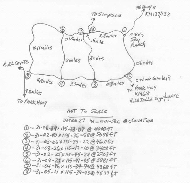
TMW - 2-20-2012 at 11:36 AM
Here is a hand drawn map of the area. You would want to go from 5 and pass 6, 7, 8, and go to 1.
Tree - 2-20-2012 at 02:55 PM
OK I've done that back route to mikes on the outside trails before but that was before the rock slide. I did not do the start of the inside route but
I beleive I picked up the 2nd half of it were its coming from Valle Trinidad but it looks like it might be the best option.
Thanks
astrobaja - 2-21-2012 at 07:57 AM
Tree, not sure if you know but motorbikes are strictly prohibited in the park itself. There is an ancient path leading from the observatory down to
the road that leads to Mikes but its death-defying! We had a cabalgata come to stay with us last year, they took that path by foot and horse and had a
helluva time, took them 9 hours!
Tree - 2-21-2012 at 10:47 AM
Thanks for the info. Nothing from the observatory so It looks like we'll either go in at the trail by los coyotes and stay the night at Mikes or just
head further north up the 1 to Valle Llno Colorado to the conector road that crosses into Valle Trinidad and around that way but it seems like alot of
miles for one day to get to San Felipe. Anyone have information on the dirt road before camalu that goes by aguaje del burro and el carricito and
connects to observatory road?
David K - 2-21-2012 at 11:01 AM
If you get Kacey Smith's GPS Guidebook for motorcycles (Vol. 2), you will have a single track that goes from Hwy. 1 (in the region of San Agustin/ El
Marmol rd.) across to Hwy. 5, just south of Puertecitos "The Bill Nichols Trail". See http://www.bajagpsguide.com
The next trail across is the El Camino Real from Mision Santa Maria to Gonzaga Bay, but this is very extreme and only one m/c rider I know did it
(with damage to his bike), Kevin Ward... Perhaps Malcolm Smith too?
The next track across is in Kacey's Volume 1 guide and is called the XR Ride. It can be traveled in a short wheelbase 4WD, but is difficult. It goes
from just south of El Pedregoso (the boulder mountain) to the Turquoise mine 3 miles north of Las Arrastras site off Hwy. 5 ... Sometime called
'Coco's Shortcut' as it is a few miles north of Coco's Corner. Baja Nomads worked on this abandoned mine road a few years ago and 'The squarecircle'
drove it in a Land Rover LR-3... Photos and more posted here on Nomad (La Turquesa Canyon Road).
Here is a neat story about Bill Nichols from Kacey: http://www.bajagpsguide.com/index.php?option=com_content&...
[Edited on 2-21-2012 by David K]