BajaNomad

Hello Baja!!! Feel that quake???

Hook - 4-12-2012 at 12:33 AM

About 12:20 MST, we just had a pretty long and moderately strong shaker over here. How about you?

Watch for puddling!!!

Hook - 4-12-2012 at 12:36 AM

HOLY CHIT!!!!

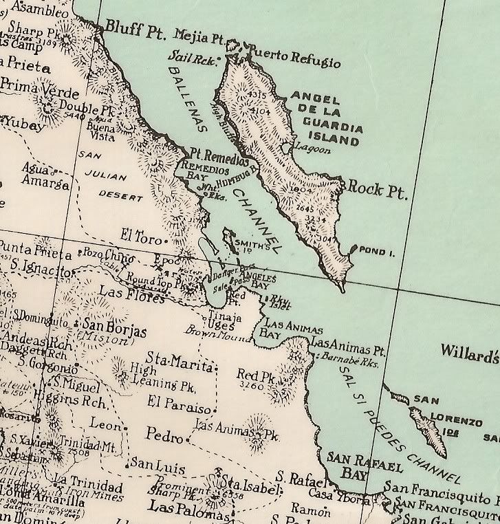
7.1 AND JUST SOUTH OF BAHIA LAS ANIMAS!!!!!

Hook - 4-12-2012 at 12:38 AM

Already downgraded to 6.9.

http://earthquake.usgs.gov/earthquakes/eventpage/usc00091a1#...

Hook - 4-12-2012 at 12:56 AM

USGS reporting two within nine minutes; a 6.2 and a 6.9.

People in BOLA must have felt this pretty good, if it woke us all up over here about 100+ miles away.

[Edited on 4-12-2012 by Hook]

TheColoradoDude - 4-12-2012 at 01:08 AM

I am right with you.

Eerie that no one from over there has posted yet.

[Edited on 4-12-2012 by TheColoradoDude]

chuckie - 4-12-2012 at 05:34 AM

iiiiiiiiiii hhhhaaaaaavvvvveeee bbbbeeeennn ttrrrryyyiiinnng tttoooo bbbbuuut tttthhhheee kkkeeeeyyybbboooaaard wwwoooonnnnt ssstttttoooppp mmmmoooovvvviiiiinnnng.....:no:

woody with a view - 4-12-2012 at 05:48 AM

that's a biggie! the one in Indo lasted 4 MINUTES!

i hate earthquakes.....

woody with a view - 4-12-2012 at 06:05 AM

http://news.yahoo.com/strong-earthquake-strikes-off-coast-me...

Hook - 4-12-2012 at 06:34 AM

No reports from BOLA?

I checked their message board but that board get an average of about one post a week.

larryC - 4-12-2012 at 06:36 AM

That was a good foot massage last night. It was actually 2 seperate quakes 9 minutes apart, not one lasting 9 minutes. No damage that I have heard about yet on the vhf radio. I am going into town in alittle bit so I will check it out.
Larry

Hook - 4-12-2012 at 06:42 AM

Quote:
Originally posted by Don Jorge
"Estoy entre un temblor y otro, aunque parece que el mas fuerte ya paso, sigue habiendo replicas, y yo que ya estaba en mi quinto sueno, creo que ya mejor no me duermo, por lo menos las casas y el hotel siguen en pie, y yo con un sueno, mis huespedes dormidos, mis vecinos dormidos, ni con quien platicar es tan noche bueno tan temprano porque aqui es la 1 am"


Sounds like most of them slept through it, eh? Or went right back to sleep.

Juanita - 4-12-2012 at 06:44 AM

Yes, I felt one, at about 1:15 a.m., a jerk toward the south and then a long, gentle, east west roll. I don't think anything here would have fallen, unless already on the very verge of collapsing. This is the second I have felt in nine years.

Meany - 4-12-2012 at 06:45 AM

Wow! ...that was kinda fun. On our way to Punta Chivato we stayed in Malarrimo in Guererro Negro last night and woke up around midnight to feel the bed shaking. My wife said it wasnt an earthquake cause the window shades werent shaking.....THEN a few minutes later the bed started shaking again and kept getting stronger. it went on for a loooooong time. Couldnt go back to sleep waiting for the tsunami...:wow::lol:

larryC - 4-12-2012 at 06:45 AM

That one would have been difficult to sleep through, at least here in BoLA. No chatter on the radio so I am assuming no damage.
Larry

4baja - 4-12-2012 at 07:01 AM

if you had enough beers you could sleep through it. a few years ago i was at my place in bola when one hit and it threw me off the bed into the hallway. i thought my buddies were screwing with me.

shari - 4-12-2012 at 07:02 AM

wow, I'm surprised you felt it all the way to San Ignacio Juanita...nothing felt here in Asuncion. I wonder if there will be more today...hope everyone in BOLA is fine and just a bit shook up.

Hook - 4-12-2012 at 07:02 AM

LarryC, this is the third quake I can remember from that area in the last year or so and in all cases, the USGS is referencing it as occurring near Santa Isabel. I'm not aware of any community or rancho named that out there. Where does that name come from?

Elena La Loca - 4-12-2012 at 07:25 AM

http://www2.ssn.unam.mx/website/jsp/ultimos.jsp

larryC - 4-12-2012 at 07:32 AM

Quote:
Originally posted by Hook
LarryC, this is the third quake I can remember from that area in the last year or so and in all cases, the USGS is referencing it as occurring near Santa Isabel. I'm not aware of any community or rancho named that out there. Where does that name come from?


No idea, their map must show some rancho or something out in the desert. I know the area pretty well and I do not know of a Santa Isabel. From looking at the usgs coordinates it appears the epicenter was pretty near the southern end of Angel Is. about 15 to 20 miles from here. The last big quake here was in the summer of 09, and it was also a 6.9. I wasn't here for that one, but this one was a really good shaker. It took me almost 20 minutes to go back to sleep.:lol:
Larry

rts551 - 4-12-2012 at 07:33 AM

Quote:
Originally posted by Juana
Yes, I felt one, at about 1:15 a.m., a jerk toward the south and then a long, gentle, east west roll. I don't think anything here would have fallen, unless already on the very verge of collapsing. This is the second I have felt in nine years.


You sure that was an earthquake?;D

Hook - 4-12-2012 at 09:03 AM

Was Marv the first one to take the group to BOLA? 'Cause I know the program was in existence long before Marv took it over.

I seem to remember that a community college also has some kind of field studies program there. I believe they have a compound right at Guillermo's. Think it is/was a school from the Valley.

But, admittedly, I havent been to BOLA since the early 2000s now.

[Edited on 4-12-2012 by Hook]

Iris Seismic monitor website

windgrrl - 4-12-2012 at 09:10 AM

Another reference that features a summary of earthquakes headlines:
http://www.iris.edu/seismon/
http://www.iris.edu/seismon/last30days_N_Pacific.html

Looks like a pretty active period around North America these days:wow:

DavidE - 4-12-2012 at 09:11 AM

The coast of Michoacan had a 6.5 yesterday at noon. Hope this isn't a precursor for a big mamacita up in California!

Hook - 4-12-2012 at 10:33 AM

I remember Phil and had his wife Patricia as an English teacher at Saddleback in the early 70s. One of the best teachers I ever had.

I also remember Mike Gaskins and met him and his group once in Baja somewhere, cant remember where. I do think it was in BOLA. ' Nuff said about that. :saint:

Pompano - 4-12-2012 at 10:46 AM

Mulege area:

Last night while watching a late night movie..and had just dropped off to dreamland, when the bed started rocking.

For a minute I thought I had got lucky.

bkbend - 4-12-2012 at 11:35 AM

Seems like business as usual this morning in downtown BOLA. Just a few frayed nerves in the night. After the two biggies I think I slept through most of the 4.x aftershocks the map was showing.

Juanita - 4-12-2012 at 11:42 AM

Checking the old adobe this morning I could not see any new cracks, but my grandfather clock had stopped right at 1:15 a.m. The quake must have swung against the momentum of the pendulum. Over at the mission, the crack extending upward from the center of the great entrance doors to the ceiling has enlarged a little. A crack over the window in the new Museo de la Mision is a little wider, too, and some debris fell. Word has come down from Rancho San Gregorio, in the Sierra de San Francisco to the north, that they had some damage; some pillars fell.

There is a Santa Isabel just north of Mexicali.

David K - 4-12-2012 at 11:47 AM


BajaBlanca - 4-12-2012 at 01:03 PM

We never felt anything here either, Shari, but I heard from some neighbors that folks in G Negro DID .... go figure.

doublelimits - 4-16-2012 at 09:34 AM

I just returned last night from camping at Las Animas as part of the the Dana Hills trip. I was sleeping in the back of my truck during the first of the larger quakes, it was very abrupt and not a gentle roller. we were all up and awake for the other quakes/aftershocks. After each quake you could hear many loud rumblings from rockslides on the hills behind us and out at Animas point. It was also cool to see the bioluminesence in the water as it was shaking.

Just after noon on Thursday there was an aftershock and we could see a rockslide and a large dust ploom out at Animas Point as well as a slide on the large hill behind us.

It is kind of weird being so isolated and trying to gather information as to where it was located and if it was something very serious elsewhere.

Nature is cool!

David K - 4-16-2012 at 09:51 AM

Thanks for that report from Las Animas!

Hook - 4-16-2012 at 10:12 AM

David, if anyone might know what feature they always refer to as "Santa Isabel" in that area, it would be you.

Hey, it's another excuse to break out the maps again...................

David K - 4-16-2012 at 10:28 AM

Quote:
Originally posted by Hook
David, if anyone might know what feature they always refer to as "Santa Isabel" in that area, it would be you.

Hey, it's another excuse to break out the maps again...................


Santa Isabel is rancho and an arroyo about 20 miles north of El Arco, on today's maps... just north of Rancho Santa Cruz.. That's all... no town. It is an old ranch and also appears on my 1930 Baja map. For some reason Google Earth used it as a point of reference?

See it just west of San Rafael on the 1930 map... it is about 20 miles west of Bahia San Rafael on the Baja Almanac...


[Edited on 4-16-2012 by David K]

Hook - 4-16-2012 at 11:07 AM

Oh yeah, now I see. Thanks for that.

Is that peak possibly named Cerro Santa Isabel on other maps?

bajadogs - 4-16-2012 at 11:22 AM

I was sleeping in an upstairs bedroom in a house at the south end of the bay near Rincon. Man it was rockin' and rollin'. You could hear it coming like a freight train with the rock slides on the mountains to the east. You could see flashlights come on up and down the coastline. A friend drove around a bit to check on everyone. Damage was suprisingly minimal. Most people slept in their cars or trucks the rest of the night with rattled nerves. In town Thursday everything seemed business as usual. Rumor has it there were more people than usual at the church. :)

David K - 4-16-2012 at 12:07 PM

Quote:
Originally posted by Hook
Oh yeah, now I see. Thanks for that.

Is that peak possibly named Cerro Santa Isabel on other maps?


The one prominent mountain peak you can see from all around is La Sandia, less than 10 miles north of Rancho Santa Isabel.

OCEANUS - 4-16-2012 at 01:55 PM

I too was in Las Animas the night of the earthquake. The USGS site does not show it, but we felt several (around 10) earthquakes that evening. The two largest were actually events #7 and #9 that evening. My students were scared when the initial quakes occurred, but when reminded that they had nothing to worry about (i.e. a Tsunami, buildings, etc.) they were able to "enjoy the ride" when the two larger ones happened.

Being outside, this was the first time I could actually hear the Earth rumbling. I've always experienced earthquakes indoors, and that rumbling sound is lost to other things making noises. Like mentioned in the earlier post by Doublelimits, that rumbling sound was followed by the sounds of numerous rockslides echoing throughout the bay. Very cool!

When we returned back through LA Bay on Saturday, everything in town was o.k., and there was no noticeable damage to the roads back north.

David K - 4-16-2012 at 04:17 PM

Thanks for your report... So, no concern of an under-sea landslide or fault upthrust creating a tsunami?

OCEANUS - 4-17-2012 at 09:59 AM

"Thanks for your report... So, no concern of an under-sea landslide or fault upthrust creating a tsunami?"

You need to have water displacement in order to generate a tsunami. Underwater landslides will not, because they are already underwater. Thrust faulting is not common along this region of the plate boundary, as leteral or transform faulting is the norm, thus considerably reducing any potential tsunami threat.

Barry A. - 4-17-2012 at 10:09 AM

True, Oceanus, but those mountains in Baja were created by something other than lateral faulting, so upthrust or block-faulting is possible, but generally I agree with you in your above statement.

Barry

Pompano - 4-17-2012 at 10:11 AM

I believe this diagram describes the wave caused by water displacement?


Tsunamis were historically referred to as tidal waves because as they approach land they take on the characteristics of a violent onrushing tide, rather than the sort of cresting waves that are formed by wind action upon the ocean (with which people are more familiar). However, as they are not actually related to tides, the term is considered misleading, and its use is deprecated by oceanographers.

tsunami_wave_diagram.jpg - 19kB

Taco de Baja - 4-17-2012 at 10:28 AM

Quote:
Originally posted by OCEANUS
"Thanks for your report... So, no concern of an under-sea landslide or fault upthrust creating a tsunami?"

You need to have water displacement in order to generate a tsunami. Underwater landslides will not, because they are already underwater. Thrust faulting is not common along this region of the plate boundary, as lateral or transform faulting is the norm, thus considerably reducing any potential tsunami threat.


I beg to differ. Underwater slides can cause Tsunamis. Even slides a long way from the actual epicenter, and possibly slides not even associated with an earthquake event.

Here's a paper from my Alma mater:

Quote:

Landslide Tsunami
Steven N. Ward
Institute of Geophysics and Planetary Physics
University of California at Santa Cruz
Santa Cruz, CA 95064 USA

Abstract
In the creation of “surprise tsunami”, submarine landslides head the suspect list. Moreover, improving technologies for seafloor mapping continue to sway perceptions on the number and size of surprises that may lay in wait offshore. At best, an entirely new distribution and magnitude of tsunami hazards has yet to be fully appreciated. At worst, landslides may pose serious tsunami hazard to coastlines worldwide, including those regarded as immune.

To raise the proper degree of awareness, without needless alarm, the potential and frequency of landslide tsunami have to be assessed quantitatively. This assessment requires gaining a solid understanding of tsunami generation by landslides, and undertaking a census of the locations and extent of historical and potential submarine slides. This paper begins the process by offering models of landslide tsunami production, propagation and shoaling; and by exercising the theory on several real and hypothetical landslides offshore Hawaii, Norway and the United States eastern seaboard.

Introduction
Earthquakes generate most tsunami. Rightly so, tsunami research has concentrated on the hazards posed by seismic sources. The past decade however, has witnessed mounting evidence of tsunami parented by submarine landslides. In fact, submarine landslides have become prime suspects in the creation of “surprise tsunami” from small or distant earthquakes. As exemplified by the wave that devastated New Guinea's north
coast in 1998......


http://es.ucsc.edu/~ward/papers/single.pdf

Edit: Here's a visual of what happens to generate the wave.


[Edited on 4-17-2012 by Taco de Baja]

Barry A. - 4-17-2012 at 10:31 AM

Every time we think we know something, we find out we don't.

Thanks, Taco.

Barry

Bugman - 4-17-2012 at 01:31 PM

I was with my wife and 3 kids at Raquel and Larry's when that thing hit. I went through the big quake in San Francisco back in 89 and this one felt nearly as strong. That hotel was really shaking and the bed one of my kids was sleeping in had a leg collapse so he freaked out and jumped in bed with me. 2 seconds later his little brother was in bed with me two. We considered running outside but I was more worried about the deck collapsing so made the call to hold up inside. It took awhile for everyone to settle down to go back to sleep and all the aftershocks did not make it any easier. As scary as it was there really did not seem to be any major damage at the hotel or around town. One of the chairs on the deck moved several feet (glad I was not up there when it hit!). We just got back Sunday night and not sure which was worse, the quake or the 3 hour wait at the border. By the way, fishing does not seem to improve right after a major quake :biggrin:

OCEANUS - 4-17-2012 at 02:06 PM

Taco:
That is an interesting paper. It would be nice to know how much of it actually applies to the geology/faulting of the sea floor in the Sea Cortez.

Barry:
There are many examples of faults throughout the BOLA and Animas region. I've read that much of it is very old, and occurred before the land was moved to its current position via tectonics. Many of the rocks too, are igneous in origin (basalts, granites, pumice, tufts, etc.) which suggest a very rich history of formation. I've been out with geologists before who have a difficult time piecing together a story that explains the region - they just summarize the area as being very "complex" geologically.

David K: Ever since I read your lost mission post focusing on the Animas region, I've been meaning to get over there to check it out. I've been able to see the walls for years from a boat, but this year we ventured out to walk the site. We had an archaeologist with us who, aside from the man made walls, was very interested in checking out the two mesas that stretched south from the peak containing the circular "rock rooms." He seemed to think that it would be the most likely place to find more evidence of human activity because of the relatively flat and hospitable terrain. We surveyed the location extensively for artifacts (pottery, etc.) and could not come up with any good explanations for the apprent human activity. The dead palm tree was significant because it definitely appeared to be an introduced variety (possibly a date palm?) that had no business being in that part of the gulf. In any case, it was a fun activity that gave us an excuse to go out and play. Thank you for the adventure.

DavidE - 4-17-2012 at 02:33 PM

I took three semesters of geology, and when I expressed an interest in both seismology and vulcanology the professor took me under her wing. My father later convinced me that geologists earn about as much as a car wash employee...

Anyway, it is helpful to understand (simplified) that subduction events close to a shoreline that are of significant magnitude coupled with shallow depth of event center can generate substantial tsunami as well. A significant magnitude event seems to be in the Richter 7.0 and higher range.

Most of the current fracturing events seem to indicate slip-strike fault activity. But one has to wonder about the obvious upthrust seen along this coastline. It is certainly the product of subduction events.

David K - 4-17-2012 at 03:21 PM

Quote:
Originally posted by OCEANUS
Taco:
That is an interesting paper. It would be nice to know how much of it actually applies to the geology/faulting of the sea floor in the Sea Cortez.

Barry:
There are many examples of faults throughout the BOLA and Animas region. I've read that much of it is very old, and occurred before the land was moved to its current position via tectonics. Many of the rocks too, are igneous in origin (basalts, granites, pumice, tufts, etc.) which suggest a very rich history of formation. I've been out with geologists before who have a difficult time piecing together a story that explains the region - they just summarize the area as being very "complex" geologically.

David K: Ever since I read your lost mission post focusing on the Animas region, I've been meaning to get over there to check it out. I've been able to see the walls for years from a boat, but this year we ventured out to walk the site. We had an archaeologist with us who, aside from the man made walls, was very interested in checking out the two mesas that stretched south from the peak containing the circular "rock rooms." He seemed to think that it would be the most likely place to find more evidence of human activity because of the relatively flat and hospitable terrain. We surveyed the location extensively for artifacts (pottery, etc.) and could not come up with any good explanations for the apprent human activity. The dead palm tree was significant because it definitely appeared to be an introduced variety (possibly a date palm?) that had no business being in that part of the gulf. In any case, it was a fun activity that gave us an excuse to go out and play. Thank you for the adventure.


Glad you liked it...

Finding that site has been a goal of mine for many years (first read about it in 1973). I got to meet Choral Pepper before she died (10 years ago) and she wished me well to find it, as she couldn't remember the location. I also talked with Bruce Barron, J.W. Black and Ricardo Castillo by phone... no luck. I made a few searches for it with other Nomads... and it was a Nomad at home on Google Earth that saw the wall... I went south to confirm, and yes, it was the same!

As a follow up to my Magdalena Mystery article in BajaBound.com's Baja Travel Adventures page last month, I have the story on the 'other' Magdalena mystery submitted for this month...

Anyone interested in the lost mission discovery by Choral Pepper and the Gardner expedition of 1966, and how it looked over 40 years later: http://vivabaja.com/109/

[Edited on 4-17-2012 by David K]

Pompano - 4-18-2012 at 09:13 AM

Tuesday night, April 17. Mulege.

Another shaker late last night felt in Mulege area? Anybody else notice this?