
viabaja - 10-10-2004 at 02:07 PM
For those who are wanting to camp at Shell Island/Beach - be aware that something has been going on recently. Met a lady there who was camped on the
beach last Fri. She imparted this info from 2 weeks ago - A Mexican national came up to her and her kids and said " You do not want to camp here
tonite" Her response was yes I do. He said again - You do not want to camp here tonite - for your health" The light came on & she understood that
something illegal was coming ashore that night. She prudently packed up her stuff and moved on. Please note copy of previous e-mail on subject.
This stuff appears to go in waves during certain seasons & years. I have seen & heard pangas with no lights in the dead of night right off the shore
line. One just closes the tent flap & goes back to sleep.
Again, more info to make one's trip more enjoyable & hassle free.
"I would think access was all the time to the beach, even when it gets wet. People need to understand that is not so. The access (there are 2) and I
don't count crossing at Percebu or from Santa Maria as part of it, does get water at a 16'7" high tide. The higher the tide, the more water it holds
that equates to soft clay mud that will suck the uneducated upto the floor boards! It takes a week or more to dry out - depending on the tide height.
I pulled out a 4x4 (2) weeks ago who misjudged. His comment was he heard that it was accessable all the time, even when wet.
Just info for those wanting to camp on Shell Beach/Island. Also & unfortunate, the stretch of beach is a "zoo" during holiday weekends. I was down
over Memorial weekend and because the tides permitted access, there were (I'm not joking) at least 100+ people up & down the beach with all their
trash, loud music, & noisy ATV's! It is becoming too well known and like everything else in Baja, getting trashed. I've been down on weekdays and have
been surprised by the amount of people camped.
One other comment. The locals call that area "drug beach" due to the pangas coming in at night dropping off their loads. This is because there are no
houses there, it's not too far from San Felipe, access is reasonable with a 4x4 on low tides, and is not watched alot by the Army. For those who are
camping, keep to yourselves at night and don't put alot of interest in lights off the water."
Tis the season
jrbaja - 10-10-2004 at 02:09 PM
so to speak 
JESSE - 10-10-2004 at 02:11 PM
La Mota is coming.
For some real excitement,
jrbaja - 10-10-2004 at 02:21 PM
go remote camping along the coast anywhere between Loreto and El Centenario during the harvest season.
David K - 10-10-2004 at 03:37 PM
That's good info Chris. If I wasn't clear on the radio, it is an ISLAND, a barrier island that does (at extreme tides) get seperated from the rest of
Baja... makes the place all the more special. That elevated causeway put in about 1984 is pretty much toast, so the original track is probably best...
the one Bob and Pat Hale use to drive their motorhome (2WD) onto the beach. Here is a photo I took Memorial Day, 2003 of some four wheeler who tried
to drive to the island... across the (at low tide) empty lagoon! This was directly across from where I was camping in my Toyota.

David K - 10-10-2004 at 03:43 PM
Here is where I spent the night after exploring with mcgyver... this was a holiday weekend, but the higher tides may have limited traffic from
Percebu... That stuck Bronco is the opposite direction from the camera, across the lagoon of Percebu.

Shell Beach (Island ?)
MrBillM - 10-10-2004 at 08:55 PM
Boy, it sure makes me want to avoid the place.
As far as being an "Island" as opposed to being
part of a tidal estuary, doesn't an ISLAND have
to be surrounded by water at all times ?
David K - 10-10-2004 at 09:11 PM
Bill it is just my romantic name for this beach, since 1977... "Island" sounds more exotic, it is a barrier island, Capt. Mike's giant pilot's wall
map shows it as an island, and there already is a "Shell Beach" in Baja (at Punta Chivato).
Actually, here in San Diego we have at least three 'islands' not totally surrounded by water: Shelter Island, Harbor Island, Coronado Island.
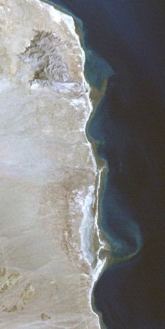
In this satellite image, the long thin beach appears as a barrier island backed by lagoons and salt flats/mud flats with Percebu to the north and
Bahia Santa Maria to the south.
David K - 10-10-2004 at 11:52 PM
Here's a closer aerial view, looking south from the north end of the island... just east of Rancho Percebu. Photo by BajaMur
in Doug Bowles' Cessna 206 enroute to Alfonsina's.

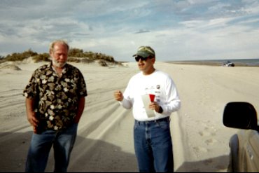
We meet 'Via Baja'
David K - 10-10-2004 at 11:59 PM
Here is Mike Humfreville and Via Baja on Shell Island, Feb. 2004.
David : Another Ersatz "Island"
MrBillM - 10-11-2004 at 08:46 AM
The most "odd" Island of all is NORTH ISLAND which is simply
the North End of Coronado Island.
Stuck Bronco
viabaja - 10-11-2004 at 10:56 AM
Dave,
In regard to the stuck Bronco, I met the owners group last July 4th. They were camping on the north end of the beach. This time they were driving a
beautiful kicked up Ford Excursion. They were all from S. Africa, working in L.A. They said that Bronco was stuck for 3 days!
Long story short - I drove my CJ5 through some mud & salt water and misjudged the water depth (yes, I erred despite my knowledge of the area)! It was
a very high tide that weekend. The CJ died with water upto the floor boards. Not stuck, just wet. Could not start it! These guys were kind enough to
winch me out and tow me back to Percebu when we couldn't start it. What a great group of people! Their story of the Bronco, being stuck for 3 days
came out during conversations.
Took the CJ home for the summer and refurbished it. Saltwater is not kind to a 24 year old machine nor my checkbook! MrBillM, who is my Percebu
neighbor couldn't beleive it!
Chris
synch - 10-11-2004 at 11:20 AM
So does the tide ever fully submerge the barrier island there?
viabaja - 10-11-2004 at 12:06 PM
Normally no. However, the water can at times (high wind, high tides, storms) creep over the top of the beach by the dunes and go over into the back
estuary.
Does anyone know this guy...
Herb - 10-12-2004 at 08:23 AM
A few years back, I was camping with my daughter at Percebu during a high tide time, and I encountered this guy who lived in the area and obviously
new the tides well. He would drive out to this spot during low tide (dry all the way) and launch his boat from a trailer. He would then go out fishing
until the next low tide when he would return and hook up his boat and tow it back across the dry sand. The first time he parked there, I watched the
tide coming in and thought, "OMG he's out at sea and he's going to be really bummed when he comes back!" But he obviously knew what he was doing as
his car stayed high and dry on it's own little "island".

Local Knowledge
MrBillM - 10-12-2004 at 11:57 AM
Back in August, I drove out on that very same sandbar
In one of my Samurais. It was about an hour before
high tide and I GUESSED that I would be OK. As the tide
came in, it got closer and closer, first covering the
middle of the bar. I got more and more concerned,
however it stopped INCHES short of my wheels to my
relief. When I drove back up the hill later in the
afternoon, a neighbor couple said "Boy, you sure know
those tides". Right ! I just said that it took
experience and didn't mention that I was sure I
might have screwed up.
It is pretty easy to guage approximately if you've
been there the day before and you've consulted the
tide calender, but it's not an exact science,
especially if the wind comes up.
viabaja - 10-12-2004 at 12:07 PM
Bill said it right!
If the wind had come up , even on an out-going tide, the water could have come up another 3-6 inches. The wind could be blowing 30-50 miles south of
there and you wouldn't know it. But you'd find out when the tide exceeded the chart numbers! The guy in the picture was pushing his luck!!
That would be a cool picture
jrbaja - 10-12-2004 at 12:42 PM
1' wind chop and a truck sitting there.
Who's first ?
Cool photo!
synch - 10-12-2004 at 12:52 PM
The blue-green water behing the truck sure makes it look like there is some depth right off the sandbar island
HotSchott - 10-12-2004 at 04:14 PM
We were there in July / August. Tides were at 19' 5" and the island was an island from all directions. The levy is still the best approach even in
it's current condition. The "Slot" right before the beach is usually 6" to 8" of mud and gets torn up with each high tide over about 16'. If there
is any wind the levy is at least three feet deep and you are not leaving or entering the island for three or four hours. If you stay on the
"two-track" as Neal Johns calls it and you have 4x4 traction I believe it is passable at its worst. After the high tide fills the Slot there will be
a fresh layer of mud, but it is compacted sand below. There was at least five feet of water over the the end of the levy on July 30 and 31st. I had
the truck backed up on the dunes and the water was over the island in a couple of spots just north of where we camp. The high water mark was about
10-feet from our camo net / palapa.
I am curious about the original thread here. Who was the woman camped with her kids? Has she ever owned a Rottweiler? I am guessing she was camped
right near the entrance (a place we usually avoid because of the traffic). She should have told the clown that there would be sixty girlscouts camped
there in a couple of hours.
All told I have camped there 14 or 15 times in the same spot over the last few years. Even during the busiest holiday weekends I have never seen more
than 25 or 30 people on the island and few stay overnight. As beautiful as the place is, it can be inhospitable. Daytime temps over 100 and 85 - 90
percent humidity and no shade that you didn't bring with you. It can be extremely windy with absolutely no notice. No kidding, zero to sixty MPH
wind in 30 seconds! It gets cold in the winter at can be cool anytime. I have spent time there and seen noone for days at a time. We did not see
one person for three days at the end of July. I have never seen anyone other than the fish camps leave any trash on the beach. I don't believe that
anyone should ever be threatened into leaving there. It is one of the few, beautiful open access beaches I have seen that are as clean and offer
potentially mesmerizing days and nights. The big tides on days with little wind and a full moon - or new moon with a trillion stars make this place
one of the most unique camping locations this close to the USA. There are still fish to be caught from the shore too.
I can't even count the good things about a trip to shell island. It is truly a special place.
Steve
HotSchott - 10-12-2004 at 04:19 PM
[Edited on 10-13-2004 by HotSchott]
Experts
MrBillM - 10-12-2004 at 05:24 PM
"When the waves are crashing against the barrier island in the distance
on the worst windy day, the lagoon can be almost perfectly flat. The wind
may push the tide higher, but there are only man-made waves in that lagoon
bigger than a few inches."
The above quote is amazing to those of us who have lived there for over 20
years. I've seen some REALLY rough water in that lagoon, especially during
the Fall-Winter-Spring when the wind is from the North. I once left my 14'
sailboat anchored out on the beach in February and the wind came up during
the night. The wind and waves the next day were such that it might have
been suicidal to try to move it. Luckily, it didn't suffer any damage other
than a mast FILLED with sand when the tide went out and the wind pushed the
boat over.
The depth of water where the truck is parked on that kind of tide is 7-10 feet
just 25 feet or so to the South. That's why it's a favorite spot of mine.
Even on mediocre tides, there is swimming depth.
HotSchott - 10-12-2004 at 08:53 PM
I guess I should have just stayed in my hole and written nothing. For those of you that have lived at Percebu for 20 years there is probably very
little that you don't know. Given all the time you would have had to contemplate nothing at all, you have probably forgotten more than I will ever
know about the area. I was not trying to obtain EXPERT status in yours or anyone elses eyes.
I should somehow more humbly offered up that due to the natural protection afforded the lagoon by the barrier island, it is not uncommon, in my novice
opinion, to have somewhat nasty conditions on the windward side and be quite pleasant on the leeward side.
Since most of my recent experiences at Percebu, albeit meaningless compared to the vast knowledge of most locals, are while camping on the island on
the windward side, I can relate to recent foul weather. The water may be churning on the Cortez side and yet very near the shore on the lee side it
is perfectly calm. The conditions on the opposite side of the lagoon might be more like the windward side of the barrier island since that shore is
not in the shadow of the island. I might also add that I don't make a habbit of camping on Shell island during a gale, although I have been there and
endured weather that cleared the beach of most other campers. It was still calm on the lagoon side by comparison.
David K - 10-12-2004 at 09:33 PM
HotSchott descibes Shell Island just the way I have experienced it... having camped there dozens of times since 1977.
The choppy (from wind) Cortez side of the island is as different from the lagoon side, which has always been smooth as glass, as night and day. This
is about a mile south of the lagoon's mouth at Percebu, mind you.
Last time I camped there with both my kids, a gale to hurricane force wind came up about 3:30 am and had us do an emergency break down of camp and get
off the island! HotScott was camping just over the dune from us and he later told me the wind died as quickly as it had came up... just a short time
after we left!
Again, this is roughing it, camping in the open, just tents and sun shade... it's part of what makes my Baja experience great! If you want safe and
predictable, STAY HOME!
Here is a happy David K with his first Subaru on Shell Island, March, 1978...

David K - 10-12-2004 at 09:38 PM
When we would stay on Shell Island for a week, our camp was more substantial for sun protection. Can you believe all THAT fit in a Subaru!!??

I am standing on the sand dune to take this photo... from early 1980's The Subaru here was my second... the first was so great as a super sand bug,
and this was as good! Just a 1600cc four banger and 13" tires... Four wheel drive and dropping the little tires to 10 psi made this unstoppable on
that bottomless sand. I wish my Tacoma drove as easily in the sand... I guess it's the weight?
[Edited on 10-13-2004 by David K]
Never question a tourists ideas
jrbaja - 10-12-2004 at 09:40 PM
As they will probably be writing a guidebook about it.
HotSchott - 10-13-2004 at 06:52 AM
JR - are you writing a book?
Lemme guess: Berkshires to Baja - A cacophony of intellect and perspective.
[Edited on 10-13-2004 by HotSchott]
synch - 10-13-2004 at 08:38 AM
David K - I can'tr see those 2 images, just a red X like the link is bad
Actually
jrbaja - 10-13-2004 at 08:39 AM
I'm more into pictures but nope, no books in the plans. Way too many already!
Different Conditions
MrBillM - 10-13-2004 at 10:45 AM
It is true that the conditions in the Estero vary according to how
far South you are. At the North end, where Rancho Percebu is located,
It is fully exposed to wind conditions from the North to Northeast
quadrant and tends to get pretty rough when the wind gets up, especially
since 1997 (Nora) when the Estero became much shallower. To the South,
it will remain calm so both estimates of conditions are correct at one
time or another.
I'm reminded of the first book that Earl Stanley Gardner wrote on his
trip to La Paz (1947 ?). He had written about a particularly bad curve
that he called the "point of the picture of Death". Years after the
book's publication, he received numerous letters from people who were
critical of his description because they found it nowhere near as bad
as described. He added a note to later additions that the reason was
the area had been widened and made less dangerous so it no longer
represented what he had written so his description AND those critical
were both correct.
Shell Beach/Island
Bajagato - 10-13-2004 at 10:58 AM
Well that one picture really tells it all! I have never posted pictures on this site so I am going to try, here is bajaddict fishing in the same spot
as that guy was on the tiny island..lets see if this works....
Shell Beach/Island
viabaja - 10-13-2004 at 11:32 AM
Hey all,
Why don't we all just take out a front page ad in the L.A. Times and tell everyone what a great spot this is! This way, we can have 120 girl scouts,
more trash, everyone with a 4X4, more people fishing, & hopefully houses built!!
By the way, it isn't the Mexican shark fisherman with the trash problem (granted they do leave some by their campsites & usually it's fish
carcass's), but the Americanos. Go visit a campsite after everyone's left and you'll get the point! July 4th was the ultimate! I lost count of the
Budweiser beer cans. Granted, there are people who cool and remove their trash when they leave.
For those who say it's never crowded, I disagree. But then again, I still remember it from 70's!
From that picture,
jrbaja - 10-13-2004 at 11:43 AM
I don't think an ad in the newspaper is necessary
RELAX!!
David K - 10-13-2004 at 05:46 PM
This is not the L.A. Times, it is Baja Nomad! You are sharing with Baja loving people, not the roudy hords from Semana Santa week (mostly from
Mexicali) and some form San Diego and Tijuana.
The people who are seeing this are the people who love Baja, respect Baja, don't leave trash on the beach... or drink Budweiser!!!
Anyway, in my 27 years camping on Shell Island it still looks the same (to me), man-made Global Warming hasn't raised the sea level (otherwise we
would never get out there anymore). The coming of pavement and a new road onto the island, bulldozed in, didn't end the island's life.
The worst campers I have witnessed who leave trash (and dirty diapers) are mostly Mexican nationals... sorry, but true. Perhaps it is because they are
not 'guests' like we are, in this land. Or it is just the time thing... we were pretty trashy before the 1960's (give a hoot don't pollute...)
I have hauled out more than I hauled in on Shell Island (and other places)... trash is gross and ugly and I love a clean Baja!
--------------------------------------------------------
BajaGato... that is a great photo (on the north end of the island looking across the mouth of the lagoon at Percebu. Good seeing you posting here!
Synch, try refreshing the page or returning another time to see the photos... Or go to where they are in my Baja Album and Nuevo Mazatlan web pages
(listed in my Index at http://community-2.webtv.net/drdrip/index )
HotSchott - 10-13-2004 at 06:36 PM
I have to agree with David K on the Shell Island thing. I have been visiting percebu since 1985 and have been camping on the island regularly for the
last five years. You gotta wanna be there to get there and if you are simply an idiot looking for a place to trash - it is a hell of a long way out
of the way. We always take a couple of full bags of trash home with us - some of it is ours. It will be a major undertaking to construct anything
out there bigger than a pile of rocks and the location is completely in the Federal Zone.
I met a guy from San Felipe that owns one of the hotels and he claims that he has title to the land. Who knows...Given the rate of development in the
area, I suspect that some burro will find a way to restrict access to the campers and it will become off limits in the next five to ten years. Or
not.
What I do know is that it takes balls to camp out there for more than a couple of days. Your basic idiot gets stuck before they get there and the
rest usually can't handle more than a day or two in the elements.
Its a cool spot and with the right kind of people going there it will stay pretty much what it is now - I hope. Wouldn't it be awesome to be able to
catch 30# Tutuava and big Corbina from the shore (like the 60's) and cook them up right on the beach?
This forum is how people get interested in places and learn to care about resources. Stewardship works. Rather than b-tch about the trash and
people, confront the problem. Pick up the trash if it bugs you (My wife and I do). Bring some extra hefty bags and ask the campers next to you to
use them. Whats the worst that can happen? They give you the finger and leave their trash anyway? For those of you fortunate enough to live down
there, why not take a few minutes out of your busy day watching the tide come in and become proactive and reverse the degradation? I would rather
have 120 girl scouts than one drug-running panga.
End of rant.
Steve
Right on HotSchott!
David K - 10-13-2004 at 08:29 PM
HotScott is serious about his love of Baja and his Chevy 4X4!
viabaja - 10-13-2004 at 09:28 PM
All right all right!!!
You guys have put me straight (isn't this great)!!
But seriously, the majority of the trash on that beach is from people camping who are 99% American. I'm down there usually twice a month and very few
Mexicans will stay on that beach with the exception of the fishermen. They prefer the campgrounds as in Percebu
I agree also, they much don't care about the environment. But they are getting better about it.
According to Sr. Lopez, Percebu's patron, the gov't holds title to that area and have made it a marine preserve. I know the El Dorado Co. tried to
hold on to it. That empty concrete house in the mud flats & old well on the way in was theirs. I met some yahoo from L.A 3-4 years ago who claimed he
has a portion of it too. However, if some corporation came in and spent millions (jetty rocks & culvert for the road), power, water, etc., I'm sure
Fox & Co. would change their minds. I heard some Japanese Co. looked at that and determined it would have been to cost prohibitive for the return on
their money. This was several years ago.
Also, I commend everyone who takes more trash out than is brought in! Fantastic!
Mas tarde.
David K - 10-13-2004 at 09:35 PM
Thank you Chris for starting this thread so we could talk about our favorite Baja beach (that's within 6 hours drive from home)!
Folks, I highly recommend you view ViaBaja's web site if this area is of interest to you. He also has GREAT historic photos of San Felipe,
Puertecitos, as well as Percebu, Shell Island, and Bahia Santa Maria over the years. http://www.viabaja.com 
California Rancho Adventours!
viabaja - 10-14-2004 at 12:34 PM
If anyone has missed this, check the link. This has been on-going for over a year now. It's being funded by the Italians. Quite the affair!!
I still can't fiqure out on how the Feds will permit the marina to be dug to ocean. It's an environmental impact issue. There is giant plan in place
to develope & upgrade current harbors (SF is part of this plan). It's on the net somewhere.
http://www.xdreamrancho.com/
bajagato, way cool photo!
bajapablo - 10-14-2004 at 01:34 PM