BajaNomad

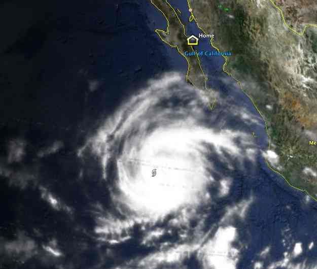
Look out below! hurricane Miriam...

 Pages:  1  

woody with a view - 9-22-2012 at 05:59 PM

http://www.stormsurfing.com/cgi/display.cgi?a=npac_height

looks like Miriam may become b-tchy in her old age!


[Edited on 9-25-2012 by BajaNomad]

Bob H - 9-22-2012 at 06:17 PM

Wow, GREAT link !

And, look at this, after clicking on this link, click on SURF

http://www.stormsurf.com/locals/ccal.shtml

[Edited on 9-23-2012 by Bob H]

Cisco - 9-22-2012 at 06:19 PM

Quote:
Originally posted by Bob H
Wow, GREAT link !


Looks like Shari will have no problem keeping the dipping pool full.

woody with a view - 9-22-2012 at 06:24 PM

yeah Bob. how do you think i get more good waves than your average hodad?

Bob H - 9-22-2012 at 06:29 PM

Quote:
Originally posted by woody with a view
yeah Bob. how do you think i get more good waves than your average hodad?


Every time I hear the word "hodad" I want a burger in OB

woody with a view - 9-22-2012 at 06:49 PM

remember when it was in the grassy area north of the lifeguard parking lot? My buddy Dave's mom has owned it since the lean days......

805gregg - 9-22-2012 at 07:03 PM

I lived 1/2 block from the beach in 1972, on Santa Monica ave in the green cottages, mine was the last one from the street next to the alley, $125 a month. I roofed all day and came home and surfed OB everyday. Allthough I lived there over 2 years we never ate at Hodads, it was just a greasy spoon back then. But I do remember breakfast every sunday at Margaritas on Newport and the Black.

Ateo - 9-22-2012 at 08:28 PM

Miriam is on Surfline's radar.............looking good.

Ateo - 9-22-2012 at 08:30 PM

We are currently watching tropical storm Miriam spinning well offshore from Mainland Mexico, which is gradually strengthening and tracking NW, soon to be in the SoCal swell window. If Miriam stays on track to the forecast, then we'll see a decent pule of SSE tropical swell (155-170 deg) build into Southern CA over Tuesday and top out Wed/Thurs+. Stay tuned and be sure to check out HURRICANE TRAK for all tropical swell info.

That meeting with South Swell and Northwest (it's alive!!!!!!!!!) means O'side is gonna be peaky and bowling!!!!!!!!

55steve - 9-22-2012 at 09:12 PM

It's still a greasy spoon but the stoners in OB seem to worship it for some reason.

Quote:
Originally posted by 805gregg
I lived 1/2 block from the beach in 1972, on Santa Monica ave in the green cottages, mine was the last one from the street next to the alley, $125 a month. I roofed all day and came home and surfed OB everyday. Allthough I lived there over 2 years we never ate at Hodads, it was just a greasy spoon back then. But I do remember breakfast every sunday at Margaritas on Newport and the Black.

shari - 9-22-2012 at 09:22 PM

well Miriam was a hot topic at the Brat-fest in Campo Sirena tonight...hosted by a Loreto Nomad...un friggin believable BBQ'd brats complete with saurkraut(sp?) and potato salad....and everyone was pretty concerned about hot Miriam would affect their travel plans. Folks decided to head out early to get back to Loreto before the storm...others may decide to ride it out here....


AND, we had the pleasure of meeting in the flesh...wide angle wandering... and his Australian body guards.


It's all about the food....tomorrow's menu is already planned....shrimp tacos at 10, sashimi when Big Boy gets in from fishing, and BBQ'ed fish for dinner...yellowtail or perhaps a nice grilled dorado...yeah baby!

WideAngleWandering - 9-22-2012 at 10:20 PM

I'm kinda hoping for a hurricane party. You guys know how to do it right!

After several rough days in San Felipe / Gonzaga / Bahia de LA I'm glad to be enjoying the good food, good weather and great company out here in Asuncion.

bajario - 9-23-2012 at 04:53 AM

Brent gets around with those brats. Tell'em to save one for Adam.

shari - 9-23-2012 at 06:36 AM

Ahem....the models are making us a wee bit uneasy...my mind is racing to figure out all the prep we must make in the next few days...roof patching, window caulking, securing stuff, rolling in awnings, getting plywood for our nice new windows...crap...the swell is going to be INSANE! Remind me NOT to play in the blowhole por favor.


Here is this mornings news....the red X is us! Miriam is looking like she may get rather worked up and in a snit the next few days as this forecaster commented in the middle of his night shift last night. I highly suggest folks think seriously about travel plans for mid week on......da da da DUN!

storm_113.jpg - 45kB

acadist - 9-23-2012 at 06:42 AM

Is there a witch down there you will find flying her bicycle? Be safe down there!!!

shari - 9-23-2012 at 06:46 AM

hey that's freaky that the model graphic posted twice in the same post and I only clicked once on it....no really....it's giving me the creeps!

I am looking forward to Wide Angle Wandering's hurricane photos....I think.:o

hmmmm....better start stocking up on Tecate now.

bajajudy - 9-23-2012 at 07:02 AM

Shari
I think that you are safe
Carry on with the party

miriam.gif - 33kB

redmesa - 9-23-2012 at 07:02 AM

National Hurricane Centre seems to think if she makes landfall it will be about Friday with maybe 50kt. I just know my roof will be leaking, I better head down today...hahaha I wish.

MAXIMUM WIND SPEED (INTENSITY) PROBABILITY TABLE

CHANCES THAT THE MAXIMUM SUSTAINED (1-MINUTE AVERAGE) WIND SPEED OF
THE TROPICAL CYCLONE WILL BE WITHIN ANY OF THE FOLLOWING CATEGORIES
AT EACH OFFICIAL FORECAST TIME DURING THE NEXT 5 DAYS.
PROBABILITIES ARE GIVEN IN PERCENT. X INDICATES PROBABILITIES LESS
THAN 1 PERCENT.


- - - MAXIMUM WIND SPEED (INTENSITY) PROBABILITIES - - -

VALID TIME 18Z SUN 06Z MON 18Z MON 06Z TUE 06Z WED 06Z THU 06Z FRI
FORECAST HOUR 12 24 36 48 72 96 120
- - - - - - - - - - - - - - - - - - - - - - - - - - - - - - - - - -
DISSIPATED X X X X X 2 7
TROP DEPRESSION 1 1 1 X 3 11 25
TROPICAL STORM 86 48 26 15 39 55 54
HURRICANE 13 51 73 85 59 32 14
- - - - - - - - - - - - - - - - - - - - - - - - - - - - - - - - - -
HUR CAT 1 12 43 49 39 39 25 12
HUR CAT 2 1 6 17 26 13 6 1
HUR CAT 3 X 2 6 15 6 2 1
HUR CAT 4 X X 1 4 1 X X
HUR CAT 5 X X X X X X X
- - - - - - - - - - - - - - - - - - - - - - - - - - - - - - - - - -
FCST MAX WIND 55KT 65KT 75KT 85KT 75KT 65KT 55KT

shari - 9-23-2012 at 07:11 AM

this is pretty much how the models looked for Jimena and John too...oh oh...it never really got here cause it decided Mulege was a better place to eat.

But as the old folks say here...ya just never really know with a hurricane so best be prepared. Because the last few deviated and headed to the gulf, people have become rather complacent thinking the storms just wont get here...lets hope but be prepared anyway.

It WILL certainly give everyone something new to talk about this week.

woody with a view - 9-23-2012 at 07:13 AM

at least the new dipping pool can be filled with some fresh rain water.:light:

shari - 9-23-2012 at 07:31 AM

it's gonna be a life saver when the waves are 15' high and it's hotter than stink!

dtbushpilot - 9-23-2012 at 07:45 AM

This is just great, Me and the 2 cats are heading south back to Buena Vista on Saturday. I'm picturing being stranded on the wrong side of a washed out road with nowhere to go, nowhere to stay and putting up with 2 cranky cats.....sounds like "Baja adventure" to me...

CP - 9-23-2012 at 07:47 AM

Off topic but important...

Were those good lookin' Brats purchased in Loreto?

LaTijereta - 9-23-2012 at 09:31 AM

Quote:
Originally posted by CP
Off topic but important...

Were those good lookin' Brats purchased in Loreto?


Checkout this store for the brats...
:cool:
http://www.tripadvisor.com/Attraction_Review-g150772-d220282...

Loretana - 9-23-2012 at 09:45 AM

Quote:
Originally posted by LaTijereta
Quote:
Originally posted by CP
Off topic but important...

Were those good lookin' Brats purchased in Loreto?


That is our own Baja Nomad "Fish 101" Brent Currier who has brats on board.......he's coming back to Loreto from his US summer tour......the brats in question are from McBee's Brats in Amsterdam, Kansas......

I hope he saves us a few! :saint:

DavidE - 9-23-2012 at 10:24 AM

Then again, it may just drizzle off to the northwest and water the ocean. In meteorology, predicting a mid course hook shot of a hurricane is akin to predicting a mid course hook shot in golf.

Gentle rain! For the entire state! Not gonna wash the car and throw sand in its face...

woody with a view - 9-23-2012 at 10:32 AM

keep dreaming David. It is late summer and the hook is the favored track....

woody with a view - 9-23-2012 at 10:51 AM

Quote:
Originally posted by shari
it's gonna be a life saver when the waves are 15' high and it's hotter than stink!


can't wait for the pics!:light:

BajaBlanca - 9-23-2012 at 11:17 AM

at leat we are getting a little break from the unbearable hurricane weather heat .... La Bocana has been cooler this last week.

we sur have a lot of windows to board up at the new house if Miriam really comes over ):

I agree with DavedE - gentle rain gentle rain gentle rain

BillP - 9-23-2012 at 03:57 PM

That sucker is wound tight, about to be a Cat 1 at any moment if it isn't already! That said, only two of the models now say right turn Clyde . Still, she'll be throwing bands at the peninsula starting Mon-Tue.


woody with a view - 9-23-2012 at 04:40 PM

well Bill, my site is dead on accurate at minus 90 hours..... but don't trust me.

BillP - 9-23-2012 at 04:45 PM

Quote:
Originally posted by woody with a view
well Bill, my site is dead on accurate at minus 90 hours..... but don't trust me.
Not questioning ya there Woody, just passing on the latest, you're probably right.

DavidE - 9-23-2012 at 04:48 PM

Wait there, Woody; I'll come get you and bring you back so you can have a front row seat! I've been through two category 5 hurricanes, Camille and Gilberto, I am not fond of their little siblings either.

Bajaboy - 9-23-2012 at 06:26 PM

I'll be there just in time to clean up or celebrate.....:o

redmesa - 9-23-2012 at 07:54 PM

It does look like it is going to weaken quickly.

FORECAST POSITIONS AND MAX WINDS

INIT 24/0300Z 16.8N 111.3W 80 KT 90 MPH
12H 24/1200Z 17.6N 112.5W 95 KT 110 MPH
24H 25/0000Z 18.5N 113.9W 95 KT 110 MPH
36H 25/1200Z 19.2N 114.8W 90 KT 105 MPH
48H 26/0000Z 19.8N 115.2W 80 KT 90 MPH
72H 27/0000Z 21.2N 115.9W 60 KT 70 MPH
96H 28/0000Z 22.5N 116.0W 45 KT 50 MPH
120H 29/0000Z 24.0N 115.5W 30 KT 35 MPH

SMG - 9-24-2012 at 04:28 AM

I'm headed out now, was planning to cross the border Wednesday or Thursday...This could be interesting...

shari - 9-24-2012 at 06:48 AM

Interesting in an understatement SMG....Miriam is going to definitely rain on our parade and create an insane swell. I highly recommend people who have houses here to get busy today on preparing for lots of water and laying in extra provisions just in case.

David E....if the swell does what it says it's going to on the surf sites...you may need to evacuate to higher ground...like your old digs on the 2nd floor of Gypsies place so get a little ditch bag together!!!! A surf site says between 15-20 feet and at high tide, that will pass over the bank at the beach in town...but I guess that new hotel built right in front of you will take the brunt of it.

Remember Nomads NOT to camp in any arroyo...many of those nice sandy beaches ARE arroyos so beware. I would alter travel plans to be somewhere secure later this week and have extra water/food and gas.

WideAngleWandering - 9-24-2012 at 07:16 AM

What do you guys think will happen with the Santa Rosalia ferry? I know my australian body guards are planning to leave Bahia and try to catch that ferry. I'm still waffling on whether I ride things out or make a run for it, spending more time in Baha on the return trip.

This thread talks about the ferry but mentions it is small and easily delayed by rough sees:
http://forums.bajanomad.com/viewthread.php?tid=44761&pag...

Departures are Tuesday, Wed, Friday, Sat, Sun according to their web site.

Mula - 9-24-2012 at 07:19 AM

Should not affect the ferry schedule, but who knows.

It's Baja!

woody with a view - 9-24-2012 at 07:43 AM

the storm has passed the area to push high seas into the gulf. the waves travel in the direction the storm travels.

DavidE - 9-24-2012 at 07:55 AM

Hi Shari,

I have been making plans as best I can for the last couple of days. I will continue to prepare for the worst. The lady with the new hotel may not like what's coming. There's nothing like a 3 meter surge with 5 meter waves atop it to renovate coastal areas.

And separately. Thank you for the offer of the blue casa!

redmesa - 9-24-2012 at 08:11 AM

Shari, you should get lots of before and after pictures of the bay coastline. It will probably look quite different in a week if the swells and rain are as predicted. The Leys coop sure seems vulnerable. I hope my house is dried out before we get there. although my main worries are with the residents of B.A. That sand is so unpredictable and nothing there is rain proof. Is there any type of community emergency aid there? other than roaming speakers telling everyone to go to high ground. I wonder how the new astro turf will survive?

woody with a view - 9-24-2012 at 08:17 AM

new models show it going towards vizcaino putting BA in the heavy quadrant. at least it is predicted to fall apart prior to landfall. the waves, however, will still be impressively large!

WideAngleWandering - 9-24-2012 at 08:20 AM

But by Saturday, if the storm passes over the peninsula, it may be windy enough to be a problem?

http://www.wunderground.com/tropical/tracking/ep201213_5day....

aguachico - 9-24-2012 at 08:23 AM

I hope the desert beats down another hurricane and sends it packing west. There are tons of tuna to catch from San Diego this weekend and would like smooth sailing.

woody with a view - 9-24-2012 at 08:26 AM

Quote:
Originally posted by WideAngleWandering
But by Saturday, if the storm passes over the peninsula, it may be windy enough to be a problem?

http://www.wunderground.com/tropical/tracking/ep201213_5day....


it will just be a tropical storm/depression once it passes over land. nothing more than a rainy windy rainstorm. nothing to worry about. it's the beaches that are gonna get pounded by the surf and storm surge.

Wishful Thinking Ahead :)

DavidE - 9-24-2012 at 08:43 AM

Prepare For The Worst


Enjoy The Best

I sure hope you are right about the hurricane winds and rain.

I sure hope you are wrong about the intensity of the surf

Storm Miriam weather reports

shari - 9-24-2012 at 08:44 AM

I see that the cape area is getting Miriam's outer bands now. Can we please get weather updates on wind and rain when it starts?

Katiejay99 - 9-24-2012 at 09:27 AM

Hi Shari: Todos Santos is hazy/overcast, no rain, no wind to speak of. Ocean looks unsettled but no white caps.

shari - 9-24-2012 at 09:29 AM

thanks for that...calm before the storm eh!

LaTijereta - 9-24-2012 at 09:53 AM

Quote:
Originally posted by shari
I see that the cape area is getting Miriam's outer bands now. Can we please get weather updates on wind and rain when it starts?


Try this site... Scroll down for wind speeds for Miriam..

http://weather.unisys.com/hurricane/e_pacific/2012/index.htm...

bajajudy - 9-24-2012 at 10:08 AM

We are overcast, no wind, no rain.
Big swell from the SW

Bob H - 9-24-2012 at 10:23 AM

Shari, bring the chairs in....

http://www.nhc.noaa.gov/graphics_ep3.shtml?5-daynl#contents

BFS - 9-24-2012 at 10:26 AM

Head high dreamy peaks this morning. Hoping for bigger later today...

Bob H - 9-24-2012 at 10:26 AM

National Hurricane Center stuff

http://www.nhc.noaa.gov/graphics_ep3.shtml?5-daynl#contents

woody with a view - 9-24-2012 at 11:01 AM

Quote:
Originally posted by BFS
Head high dreamy peaks this morning. Hoping for bigger later today...


...and here i am waiting for a flight to work.:no:

Bajagypsy - 9-24-2012 at 11:20 AM

Miriam needs to stay away! Not cetain if our roof will take it!
Hope everyone stays safe, if Miriam does hit land.

windgrrl - 9-24-2012 at 11:25 AM

Rancho Leonero webcam facing WNW-ish to Los Barriles:
Rancho Leonero

Bill Collector - 9-24-2012 at 11:35 AM

We are just North of Rancho Leonero, we are getting a very gentle slight breeze out of the East. We are wanting the rain, but no wind Please...

micah202 - 9-24-2012 at 12:54 PM

...here's the words of some weather watchers up the coast......I'm wishing everyone well---look after the locals too if you can!
...I'm pretty concerned for all those folks in Guerro Negro and all that very flat land around there-I know there's an army post there,,but somehow that doesn't reassure me of anything

......Going into the storm archive, Miriam has beat the probability projections every day. And not by a little bit. Southern Baja is usually impacted by a tropical cyclone on an yearly basis, though Miriam is forecast to landfall quite north on the peninsula. More north than is usual.
This storm is one to watch.
I think the last tropical cyclone to really impact southern California was in the 30's, so little chance of that. Forecast is for the cyclone to collapse prior to landfall, which would be kind to the resident population of Abreojos, Accension, and Turtle Bay. The rainfall associated with Miriam could cause trouble from Baja to New Mexico, and in between.

Miriam's satellite signature isn't beautiful and it is hard to imagine without cleaning things up a bit she can remain at Category 3 strength. More later if the trajectory changes but most models are in agreement that a mid peninsula strike as a TS is the most logical solution. Things have been trending north a bit though...

[Edited on 9-24-2012 by micah202]

BajaBlanca - 9-24-2012 at 01:18 PM

I don't evenknow where to start preparing for this hurricane .... our palapa roof will end up in abreojos for sure ....

micah202 - 9-24-2012 at 01:30 PM

Quote:
Originally posted by BajaBlanca
I don't evenknow where to start preparing for this hurricane .... our palapa roof will end up in abreojos for sure ....


...maybe warn the people of abreojos then!
...g'luck

[Edited on 9-24-2012 by micah202]

DavidE - 9-24-2012 at 02:32 PM

SUPPOSEDLY, the center of the storm is going to be HERE as a remnant low with 30 kt winds on Saturday


[url=https://maps.google.com/maps?hl=en&q=map+27.0N+113.0W&ie=UTF-8]

[Edited on 9-24-2012 by DavidE]

landyacht318 - 9-24-2012 at 02:41 PM

They are really calling on Miriam to rapidly weaken before reaching land. As fast as or faster than an Atlantic hurricane moving over land. I don't see it.

Gonna be a lot of rain regardless, and far reaching on both sides of the storm's center.

redmesa - 9-24-2012 at 03:01 PM

In hurricanes from what they say and what I have experienced, the winds are bad but the sudden huge rainstorm and high surf are what cause most of the damage. i.e. Galveston. I have been in B.A. in two rain storms and it was shocking the amount damage done to the town. My heart is going out to the people there and I so hope Miriam has a heart and dissipates quickly.

BillP - 9-24-2012 at 03:12 PM

Quote:
Originally posted by DavidE
SUPPOSEDLY, the center of the storm is going to be HERE as a remnant low with 30 kt winds on Saturday


[url=https://maps.google.com/maps?hl=en&q=map+27.0N+113.0W&ie=UTF-8]

[Edited on 9-24-2012 by DavidE]

David, check your u2u

surfdoc - 9-24-2012 at 03:35 PM

Gypsy..........no worries the pups and I will check up on your place !!!

Putting the seat in the Yak... white water down the hill to the Coop store Yeehaa!
And stocking up on Tecate and TP...........

Thanks for the links and updates !!!!

shari - 9-24-2012 at 03:41 PM

STan, when that arroyo by your house runs, you will be stranded as the road washes out down from you...maybe you should stay at Gypsies if it rains for more than 4 hours...seriously dude. From there you can access town and drive around in all the water! It's gonna be a freak show.

mulegemichael - 9-24-2012 at 04:44 PM

we've weathered julio, juan and jimena and are a little worn out from mucking out but are committed to doing it again if it happens...my honey says, "it weeds out the weak"....whatever...she's kidding, of course...just hope we don't see water over our roof again.

Russ - 9-24-2012 at 04:59 PM

I'm hoping she'll let me get home on Tues.

Ken Cooke - 9-24-2012 at 06:10 PM


Hurricane Miriam (Cat 3) Forecast Storm Tracks

bryanmckenzie - 9-24-2012 at 06:44 PM

24 Sept 2012, 9:00 hrs (Pacific) ... look out GUERRERO NEGRO (?).

Google Earth KMZ (dynamic link) file may be downloaded here (also Atlantic basin) ... http://www.tropicalatlantic.com/models/data.cgi

Checkmark box will be UNchecked. Checkmark it once, it turns off again. Checkmark it a 2nd time and it stays on.

I like to monitor:

* Orange "traffic cone"-looking placemarks are worldwide ocean buoys (Google it --- and YES, these are your USA taxpayer dollars at work; for the citizens of all countries).
* White is real-time visible cloud cover.
* Green is real-time rain/precipitation.


1400 pixel image here


[Edited on 2012-9-25 by bryanmckenzie]

Gee, it doesn't look all that big from up here ...

bryanmckenzie - 9-24-2012 at 06:53 PM

Gee, it doesn't look all that big from up here (7,100 miles up).


1400 pixel image here


Closeup of the most likely path ...

bryanmckenzie - 9-24-2012 at 06:59 PM

... Jeez, it's been quiet here on the Atlantic side all season. :P What's up with THREE major Pacific storms in just a few months?

1400 pixel image here


SFandH - 9-24-2012 at 07:05 PM

Great images, thanks.

shari - 9-24-2012 at 07:19 PM

it' supposed to rain starting wednesday evening here

Ateo - 9-24-2012 at 07:22 PM

My guess and hope is it will dissipate offshore and only bring minor winds and heavy rains.............judging by the surf sites I visit. Definitely some swell coming, but the hurricane looks like it'll fall apart. BUT- who knows what nature's opinion is??

bryanmckenzie - 9-24-2012 at 07:36 PM

De nada, amigo.

Quote:
Originally posted by SFandH
Great images, thanks.


[Edited on 2012-9-25 by bryanmckenzie]

bigmike58 - 9-24-2012 at 07:55 PM

Chris Dunn is the ch5 weatherman in phx and a So.Cal native and fisherman. He sent this email tonight with a couple of links and will keep an eye on this storm for us and send updates.


"I will record a special update and post this evening. Right now the storm could go either way as there is no clear-cut forecast track. Even if the center stays off the coast, Baja could see some heavier rain (1-3”). Not sure if that would cause widespread flooding problems in Mulege…it could if it came in one day.

Here are a couple of links for you:

http://classic.wunderground.com/tropical/tracking/ep201213_m... I like weather underground stuff

http://www.stormsurfing.com/cgi/display.cgi?a=enp_wind Closer view of eastern Pacific WWIII model of wind field

http://wxweb.meteostar.com/sample/sample.shtml?text=mmlt Grid point output from the GFS model for Loreto. Mulege doesn’t have one available, so this was the closest I could find. Keep in mind this is just ONE possible solution…and there isn’t a lot of consensus between all the models right now. Check out the “models” section on Weather underground!

Intensity forecast shows a rapid decline in wind speed once it gets away from 80° water. Looks like the center is very close to Clarion right now.
-Chris Dunn


Chris Dunn
Multimedia Chief Meteorologist
KPHO CBS 5 News

cdunn@cbs5az.com

BajaRat - 9-24-2012 at 09:09 PM

Quote:
Originally posted by woody with a view
new models show it going towards vizcaino putting BA in the heavy quadrant. at least it is predicted to fall apart prior to landfall. the waves, however, will still be impressively large!


I'll send pics of Abre Woody :spingrin:

WideAngleWandering - 9-24-2012 at 09:41 PM

I sure hope this storm is just big enough to be entertaining but doesn't cause too much damage.

If one were traveling south from Asuncion to avoid potential washed out roads & storm damage, it looks like being in Loreto by Friday would do the trick? The bit people are warning me about is the stretch from Santa Rosalia to Concepcion.

David K - 9-24-2012 at 10:38 PM

Quote:
Originally posted by WideAngleWandering
I sure hope this storm is just big enough to be entertaining but doesn't cause too much damage.

If one were traveling south from Asuncion to avoid potential washed out roads & storm damage, it looks like being in Loreto by Friday would do the trick? The bit people are warning me about is the stretch from Santa Rosalia to Concepcion.


The large Magdalena arroyo is between Santa Rosalia and Mulege... even with the dozen new bridges, it got flooded on the Mulege side and cut traffic at least a day.

Along Bahia Concepcion, the hazard is mainly from rock slides, but the small arroyos coming down from the mountain may be torrents.

Get somewhere you can stay put for a week if needed.

bigmike58 - 9-25-2012 at 05:57 AM

Here is the special report video that Chris Dunn did for us.

http://www.kpho.com/category/247096/cbs-5-meteorologist-chri...

shari - 9-25-2012 at 06:23 AM

good report....but not real encouraging for us here in the danger zone! Let's hope she cools her jets a bit before turning. It's a crap shoot.

[Edited on 9-25-2012 by shari]

miriam track.gif - 33kB

WideAngleWandering - 9-25-2012 at 07:40 AM

Quote:
Originally posted by David K
Get somewhere you can stay put for a week if needed.

Just trying trying to decide where. Asuncion to watch what happens or drive drive drive to get down to Loreto and La Paz to avoid what happens :)

Good luck everybody.

vandenberg - 9-25-2012 at 07:47 AM

From the La Paz hurricane site:

GRADUAL WEAKENING IS FORECAST DURING THE NEXT 24 TO 36 HOURS AS
SOUTHWESTERLY SHEAR INCREASES AHEAD OF A SLOWLY ADVANCING
MID-/UPPER-LEVEL TROUGH NOTED TO THE WEST AND NORTHWEST OF MIRIAM
IN WATER VAPOR IMAGERY. BY DAYS 3-5...THE GLOBAL MODELS ARE
FORECASTING A LARGE MID-/UPPER-LEVEL LOW DEVELOPING NEAR 30N 130W.
THIS LOW IS EXPECTED TO INCREASE THE VERTICAL SHEAR ABOVE 30 KT...
WHICH SHOULD INDUCE MORE RAPID WEAKENING AND POSSIBLE DISSIPATION
BEFORE MIRIAM REACHES BAJA CALIFORNIA. THE OFFICIAL FORECAST IS
SIMILAR TO THE PREVIOUS ADVISORY AND FOLLOWS A BLEND OF THE SHIPS
AND LGEM MODELS.

So, most likely, just rain!!

David K - 9-25-2012 at 08:03 AM

Quote:
Originally posted by shari
good report....but not real encouraging for us here in the danger zone! Let's hope she cools her jets a bit before turning. It's a crap shoot.


Wowsers, that map you posted has it hitting you at 2am Sunday. Yesterday's map had it hitting Abreojos.

Mulegena - 9-25-2012 at 09:00 AM

Latest sat photo update shows a big debris storm spinning off. Mulege and southland are in no danger of a hit or a flooding, imo, but we's gonna get our heads wet later today.

Gonna go get prepared.

Latah!

redmesa - 9-25-2012 at 09:25 AM

Looks like they are picking Tortuga!
http://www.surf-forecast.com/breaks/Bahia-Tortugas/forecasts...

Hurricane Miriam - When & Where will it hit??

TecateRay - 9-25-2012 at 10:41 AM

From what I can tell it looks like it will hit somewhere around Bahia Tortugas on Saturday or Sunday. It will likely be a tropical storm by then.

Any storm watchers out there have a feel for the impacts on travel down Hwy 1 and lingering effects elsewhere ? I'm heading south Wednesday and plan on about 8 days to Cabo.

Bajaboy - 9-25-2012 at 10:50 AM

Wednesday...tomorrow...or Wednesday next week? I plan to head down on Monday and will report as best I can.

shari - 9-25-2012 at 10:55 AM

We have seen this several times before...all the models point to us and everyone is racing the clock to get prepared for the worst...but for the last 10 years the storms have snuck over to the gulf side before reaching us...the problem with this is that many folks think the same thing will happen...we are lulled into complacency thinking its wont get to us again.

Juan remembers the last storm that did alot of damage...the reports all said it would only be a tropical low when it hit us and it cranked up again and did alot of damage...so he is more worried than I am! (I wasn't here for that one)

But I imagine with the 2-3 day of rain they are forecasting, the highways will be a mess starting on thursday so make sure you check the road closures before setting out anywhere past central baja. I think this site will have great up to date info on the latest road reports...IF our internet doesnt get knocked out.

DavidE - 9-25-2012 at 11:12 AM

I would packs LOTS of snacks, beverages, some blankets, repellent, flashlights, batteries, and keep the gas tank as full as possible. If I were headed south and did not pass many northbound diesel big rigs starting around San Quintin, I would grow very suspicious. Filling up with lots of rain, and a possible gas shortage means the possibility of a gasolinera sucking down to the bitter end. That means water and sediment. I would not start a trip under those conditions without having a new fuel filter in place and carrying 2 spares and the means to change them. Another tip is to ask at Antonio's Baja Cactus station but remember, their reports arrive, obsolete.

TecateRay - 9-25-2012 at 11:29 AM

Quote:
Originally posted by Bajaboy
Wednesday...tomorrow...or Wednesday next week? I plan to head down on Monday and will report as best I can.


Tomorrow. So this weekend a storm hit could definitely mess things up.

In honor of the surf being up...

vgabndo - 9-25-2012 at 11:50 AM

I'll use the term "b-tchin'" This NASA live view of the earth can be backed-up using the slider on the bottom. It may have been posted before.

http://earthdata.nasa.gov/labs/worldview/

I hope positive outcomes for everyone in the path. Otherwise, think of the giant geologic smile on the face of the aquafer as the bounty seeps-in!

Be prepared goes without saying.

Julio Sculpture...

IMG_02381.jpg - 46kB

Bajatripper - 9-25-2012 at 12:27 PM

Quote:
Originally posted by DavidE
If I were headed south and did not pass many northbound diesel big rigs starting around San Quintin, I would grow very suspicious.


Another key to this observation is one starts seeing the trucks pulled over at whatever truckstops there are along the way before one actually arrives at the problem area. I just experienced this on our return trip when a couple of arroyos at Rosarito were flooded.

A good thing, too, for it would make one heck of a long convoy if they all just kept on truckin' until they got to the arroyos. I'd hate to have to pass them all once traffic got flowing again.

As usual, your advice is spot on, David.

Pescador - 9-25-2012 at 12:45 PM

The last two rainstorms have really messed up the main highway due to flooding in the Vados. Because we have already received two major rains in the Loreto to Vizcaino area, everything is saturated (we still have standing water), so if we get heavy rain out of Miriam, the vados will run really full and I would expect some serious road closures until the water level goes down in the arroyos. All of the weather reports are indicating that we will start seeing rain at least on Friday and maybe even Thursday. So, the problem is not whether the hurricane or tropical storm makes landfall, but how much water in the form of rain we get out of this. While I do not expect a lot of wind on the Santa Rosalia side (predictions are for 20-25 knots), we are preparing for a major rainfall, and in terms of the highway, that can cause just as many problems.
Reports on this web site are usually pretty timely and accurate, and since there are enough nomads living up and down the peninsula, you should be able to get pretty current and updated information on the highway.

DavidE - 9-25-2012 at 12:59 PM

Inconvenience may be hard to take, but as I deal with lots of rain I must keep in mind that of all the things that are precious on the Baja California peninsula, water ranks near the top. Aquifers must be replenished. The cattle we see as we drive must have water and almost all of their supply relies on maintaining a dependable water table level. Ancient fig trees planted by early missionaries will die in a prolonged drought. Fertile soil in Cd Constitucion will have salt leached downward and provide more bountiful crops. Wild honeybees will go riot with the honey production and that makes me smile.

Now where did I put that @#$%^&!! Mop!

TecateRay - 9-25-2012 at 01:01 PM

Thanks for all the info and advice. I will check in daily (if there is wi-fi) to keep up to date. :yes:

roundtuit - 9-25-2012 at 01:09 PM

Will be headed for Mulege Monday so I'm sure all of us would appreciate any info here:yes::yes::yes:
 Pages:  1