BajaNomad

El Camino Real/ Google Earth/ Santa Gertrudis to San Borja

David K - 10-25-2012 at 05:48 PM

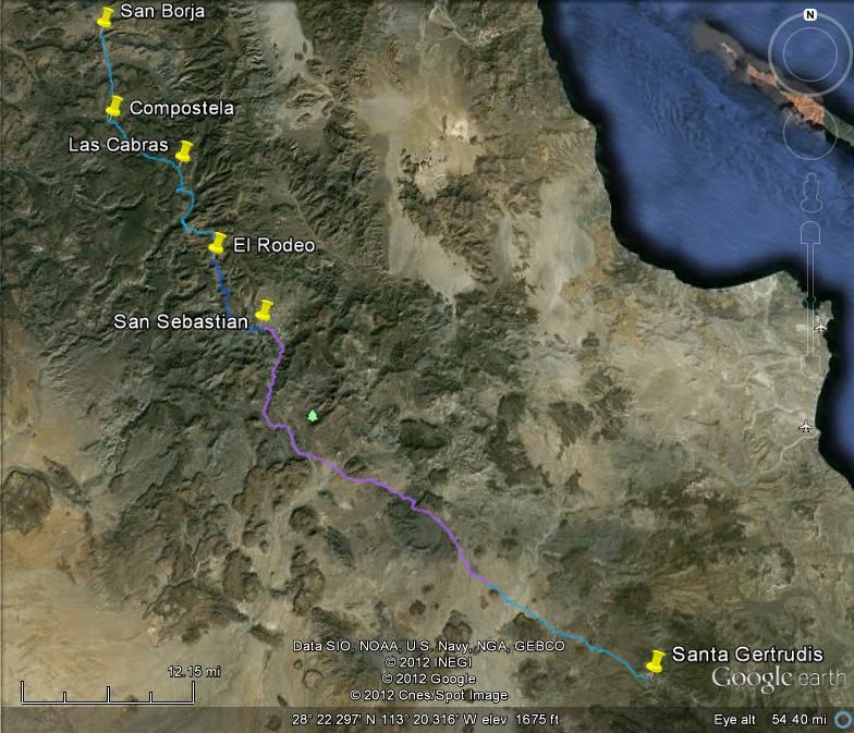
With help from Bryan Mackenzie, I started making an El Camino Real Map on Google Earth... Going down close to see the actual trail built in the 1760's between these two missions. Some places it is plain as day, others are faint to no trace, sometimes in an arroyo and sometimes with an auto road on top of it. In the past, I have shown the actual GE images of the trail and made maps (highlighting or pointing out the mission road on the Baja Almanac). Links to those posts on Baja Nomad are listed in my Baja Missions web pages http://vivabaja.com/bajamissions

Here is the high view of the entire route between the two missions.


The future of this new project is a new book on the Camino Real in California... San Jose del Cabo to Sonoma (the furthest south to furthest north California missions.

Naturally, for us to do a new project, it would help if you all would get a copy of our current book on all the missions in California! Thank you for your support!:light:;)

Baja Bucko - 10-25-2012 at 07:21 PM

David-you need to get off the web and get on a mule and RIDE ECR for a few weeks.......then write about it! .:bounce:

Baja Bucko - 10-25-2012 at 07:40 PM

There's a big difference between sitting in a chair and analyzing sat fotos and "traveling" and describing ECR and actually putting in the miles and DOING it...really EXPERIENCING IT. Kinda like writing a minutely-detailed travel guide but never having left the frontyard.

ECR is not just an ancient path in the wilderness-it is a time machine, littered with remnants of the hearts, dreams and hopes of the thousands who journeyed north and south whether indio, mission worker, miner, lost soul, soldier, gov. official, priest, vaquero, trailblazer, wife, mother, children.......

"Listen to the ghosts of those footsteps
of weary travelers long ago.
Feel the hearts of those people
who left pieces at the side of that old road"

The quote is MY writing and says it all.


I'm jus' saying.....;D

David K - 10-25-2012 at 10:31 PM

Quote:
Originally posted by Baja Bucko
There's a big difference between sitting in a chair and analyzing sat fotos and "traveling" and describing ECR and actually putting in the miles and DOING it...really EXPERIENCING IT. Kinda like writing a minutely-detailed travel guide but never having left the frontyard.

ECR is not just an ancient path in the wilderness-it is a time machine, littered with remnants of the hearts, dreams and hopes of the thousands who journeyed north and south whether indio, mission worker, miner, lost soul, soldier, gov. official, priest, vaquero, trailblazer, wife, mother, children.......

"Listen to the ghosts of those footsteps
of weary travelers long ago.
Feel the hearts of those people
who left pieces at the side of that old road"

The quote is MY writing and says it all.


I'm jus' saying.....;D


I KNOW I KNOW... and I am BEGGING you to please start writing, sharing, posting ... before that treasure in your head is lost like Mission Santa Isabel! Only your memory is for real!

Would you at least allow me to publish a chapter (if not a whole book) about your riding the Camino Real on mules?

Just think of what an influence Harry Crosby had on you and me with his works of the late 1960's and 1970's... They inspired you to do what you been doing the past dozen years since I first met you.

If I could, I would be down there on the trail... so flying over and marking it on my PC is the most I can do in these lean financial times.

Please consider it as what we publish today on the Camino Real can only spark future advocates of the history of Old California, the way Harry... and Howard Gulick's research of the 1950's-1970's inspires you and I.

Neal Johns - 10-26-2012 at 11:33 AM

Right on, DK!
That lady has a lot of stories, locked up in her little pea brain. Ja, Ja Ja!
Come on, Teddi, do it, pretty please with sugar on it.
Neal (H in W #1)

David K - 10-26-2012 at 11:54 AM

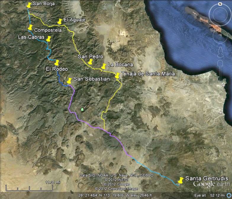
Often there was more than one Camino Real trail. Either because of the season or to serve visitas along one of the routes, the padres would travel on the alternate roads.

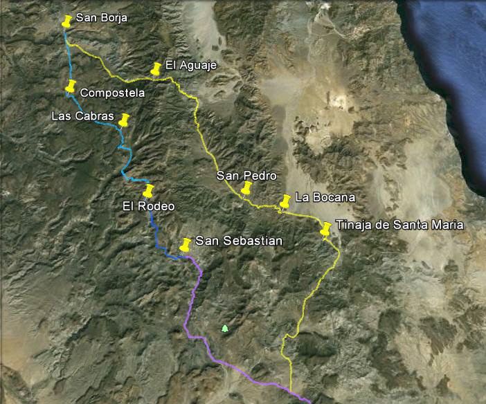
Between Santa Gertrudis and San Borja, there were three main roads... The central or 'Sierra Camino Real' (shown above); the west slope or 'Pacifico Camino Real' and the east slope or 'Golfo Camino Real'.

The Golfo Camino Real was traveled by Arthur North in his 1905/6 adventure published as 'Camp and Camino in Lower California' c1910. Erle Stanley Gardner talked about it as he and his 1966 team used some of it making a new road between Bahia de los Angeles and Punta San Frasncisquito, and wrote 'Off the Beaten Track in Baja' c1967.

The Golfo route can be seen from space, but not nearly as much as the Sierra route... where it vanishes from view, I just ran the path line on the logical route...


I have visited the Tinaja de Santa Maria twice and seen the Golfo route where it climbs the ridge just east of the water hole. Great times!

David K - 10-26-2012 at 11:58 AM

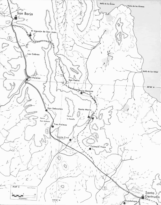
Here is Harry Crosby's 1977 commissioned map of the same area: