BajaNomad

4WD Offroad Trek: 1942 Pole Line Road (Mexicali area) + Rio Hardy BBQ with Nomad MICK 3/29-3/31

Ken Cooke - 2-19-2013 at 06:58 PM


This year's Baja Pole Line Run will take place in two distict locales synonymous with Baja California Adventure - Baja California's Rio Hardy and the ultra-rugged Baja canyonland trail adjacent to the mountainous Sierra Juarez Summit Trail - the 1942 Pole Line Road.

4WD Run Type: Bobtail Camping - 1 night at the Rio Hardy Vacation House, and 1 night in the pure backcountry.

Date: Friday March 29th through Sunday March 31st (with option to return to Rio Hardy for a free night's stay or cross the border and go home).

Location: 2013 Baja Pole Line Run
(night 1 - March 29th) Rio Hardy Vacation House (free accomodations)
(night 2 - March 30th) Pole Line Road - Caņon Enmedio (free access camping)

Facilities: Tow vehicles can be stored at the Rio Hardy Vacation House.

Leader: Ken Cooke (and Wife Leidys Cooke)

Contact: thedesertoutlaw@yahoo.com 951-255-1589 cell

RSVP: Required for BBQ and guest planning at Rio Hardy Vacation House for first night.

Run Type: Camping Run (2 Full Days on the 1942 Pole Line Road) with an optional night run to Suzuki Falls for those who can't get enough rock crawling!

Difficulty Rating: 2+ (5 being 'EXTREME')

Required Equipment:
Provisions for 2 nights of camping - 1 night in the remote backcountry.
31" Tire required.
CB Radio and Fire Extinguisher.
3 1/2 Days worth of Mexico Auto Insurance for 96 hrs./4 Days (Can only be purchased in 24 hr. increments).
One traction aiding device strongly suggested (Limited Slip).
Skid plate for oil pan, spare tire required.

Meeting Time: 10 AM - Pep Boys, Calexico, CA - 400 S Imperial Ave Calexico, CA 92231

Departure Time: 10:45 AM from Pep Boys - 400 S Imperial Ave Calexico, CA 92231

* Please have your Mexican insurance already purchased/in hand, and Passports/Visas to return to USA.

*This is going to be a fun run - one where the Wives (on night #1) get to watch their Husbands prepare a BBQ Feast along the waterfront in the historic Rio Hardy - (We will have a chance to shop for meats in Mexicali at the giant grocery store at the center of town after we eat lunch). The following two days will provide a chance for pure 4WD canyon off-roading in some of the most desolate wilderness - ripe with both flora and fauna from the Baja region. Once the run is over, drivers will have an option to stay again at the Rio Hardy vacation house, or return to the USA.

MICK and Wife Penny on the cobblestone Pole Line Road


[Edited on 2-20-2013 by Ken Cooke]

David K - 2-19-2013 at 08:07 PM

Sounds like fun... hope I can drive it someday.

Ken Cooke - 2-19-2013 at 09:04 PM

Quote:
Originally posted by David K
Sounds like fun... hope I can drive it someday.


Trade up to a Jeep? :light:

Tacodawgtim - 2-19-2013 at 09:10 PM

Is it possible to meet you at Rio Hardy? I am in San Felipe now and plan on being here for a few months. Sounds like a great trip

Ken Cooke - 2-19-2013 at 09:25 PM

Quote:
Originally posted by Tacodawgtim
Is it possible to meet you at Rio Hardy? I am in San Felipe now and plan on being here for a few months. Sounds like a great trip


That would be entirely possible. Would you be willing to meet us Friday the 28th at about Noon to 1 PM on Hwy 5? We will be traveling near El Medanito EAST to the Rio Hardy at that time. CB Channel 4 will connect with us as you travel close to the river in the general vicinity of Terrenos Indios. You will definitely need to travel north to the nearest PEMEX, filling your tank, and two 5 gallon gas cans. This is a remote 4WD run, and you'll be running on fumes by the end of the trip.

[Edited on 2-20-2013 by Ken Cooke]

David K - 2-19-2013 at 10:42 PM

Quote:
Originally posted by Ken Cooke
Quote:
Originally posted by David K
Sounds like fun... hope I can drive it someday.


Trade up to a Jeep? :light:


You misunderstand my reply, I have no worries that my Tacoma 4x4 Off Road can do the drive. Didn't you get introduced to the road by Toyota off roader Neal Johns?
I hope that I can take the days off. Because It is hard for a Toyota to drive so slow, I would meet you at the start of your run instead of Calexico. Maybe I would be already down there the day before? :light:

Ken Cooke - 2-19-2013 at 11:15 PM

Quote:
Originally posted by David K
Quote:
Originally posted by Ken Cooke
Quote:
Originally posted by David K
Sounds like fun... hope I can drive it someday.


Trade up to a Jeep? :light:


You misunderstand my reply, I have no worries that my Tacoma 4x4 Off Road can do the drive. Didn't you get introduced to the road by Toyota off roader Neal Johns?
I hope that I can take the days off. Because It is hard for a Toyota to drive so slow, I would meet you at the start of your run instead of Calexico. Maybe I would be already down there the day before? :light:


This is a very challenging route. Your truck is in very good condition. Are you sure??:?: I had better talk to Elizabeth.:!:

Best case scenario:
Huitzi and his wife plan on also meeting early on Saturday morning. I told Huitzi (Weet-zee) the meeting place will be near Mex 5 at El Medanito. We will be driving West from near Terrenos Indios to Mex 5 at around 7 am. I will ask MICK if there is a restaurant in the area we could meet at instead. This would be more convenient, but the general plan will be to meet near El Medanito at 7 AM.

Tacodawgtim - 2-20-2013 at 07:51 AM

Thanks Ken I am doing as addition on our house here so I will know pretty soon if I can sneak away plus if the wife lets me go. I have a jeep all stock and a Tacoma 4 wheel drive. The Tacoma would be more comfy ride. Ill keep in touch thanks. Hope it works out look forward to meeting some nomads and a great ride to boot.

David K - 2-20-2013 at 11:52 AM

El Mendanito, and Terranos Indios, are locations on the Almanac, north of Rio Hardy where the graded road goes west over the mountain towards Laguna Salada and to the sulfur mine. The Almanac does not show that road.

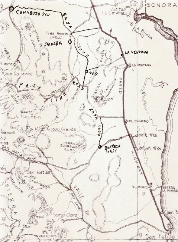
Is this a better way to reach the Pole Line instead of the closer road by the sand dunes (Ejido Saldaņa/Tres Pozos) to Cohabuzo Jcn.? Is Cohabuzo how you are heading to it?


[Edited on 2-20-2013 by David K]

Ken Cooke - 2-20-2013 at 02:55 PM

Quote:
Originally posted by David K
El Mendanito, and Terranos Indios, are locations on the Almanac, north of Rio Hardy where the graded road goes west over the mountain towards Laguna Salada and to the sulfur mine. The Almanac does not show that road.

Is this a better way to reach the Pole Line instead of the closer road by the sand dunes (Ejido Saldaņa/Tres Pozos) to Cohabuzo Jcn.? Is Cohabuzo how you are heading to it?


MICK and I are discussing a good meeting place for people that will be meeting us on the morning of Saturday March 30th. We will be traveling to Cohabuzo Junction that day, then camp along the Cobblestone just like I did in November 2011 (for the night of Saturday, March 30th).

But, for the morning of March 30th, MICK and I are talking about a restaurant or someplace where we can meet up. His home is located near El Mendanito and Terranos Indios. Meeting up someplace along MEX 5 is most convenient, comfortable, and reduces the number of variables that I will need to plan for. We will be utilizing CB Radios for this 4WD run in order that we can communicate from vehicle to vehicle, and vehicle to base camp, etc. With the number of vehicles planning on meeting us on Saturday, March 30th (3 so far), finding a good meeting place is the priority. MICK will chime in when he is able to. At the moment, he is traveling and having a great time in the Copper Canyon.

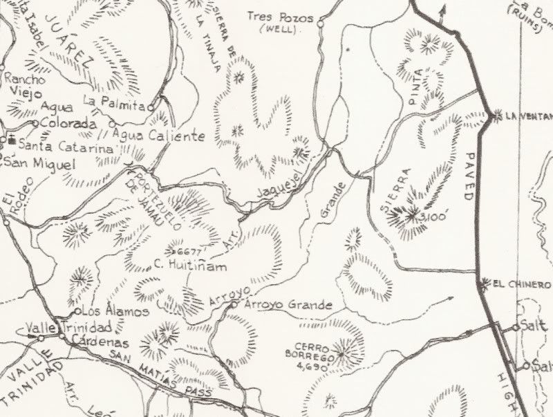
Maps!!!

David K - 2-20-2013 at 06:41 PM

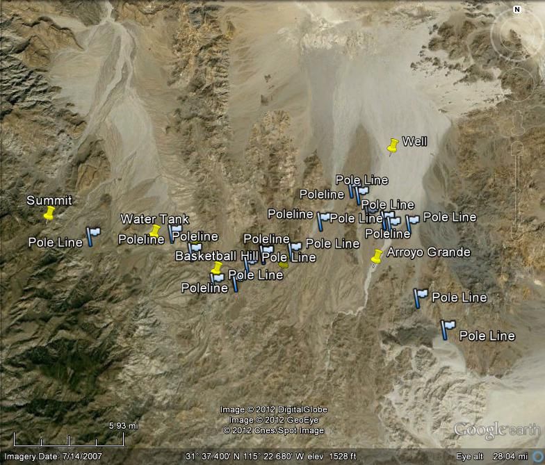
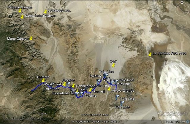
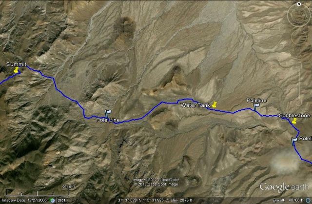
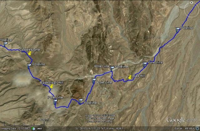
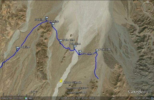
Okay, so I already had several waypoints (GPS) of the Poleline Road from TW, Ken and Neal Johns... and those are shown as flags or push pins. I just today drew a path over the road as I viewed it on Google Earth. There was only some cloud cover around Basketball Hill, otherwise I could see the entire 1942 road. I began the path from west of the summit to east of Arroyo Grande.

The poleline road serviced the WWII telephone line to our radar station near San Felipe (Punta Diggs) from the phone lines already into Ensenada, from San Diego.

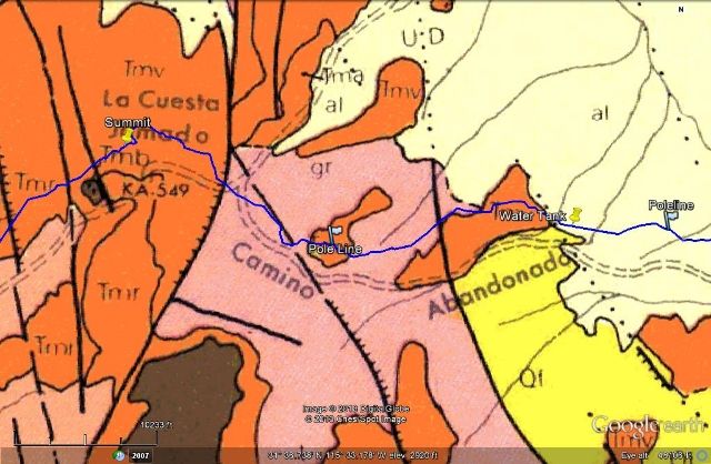
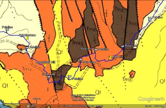
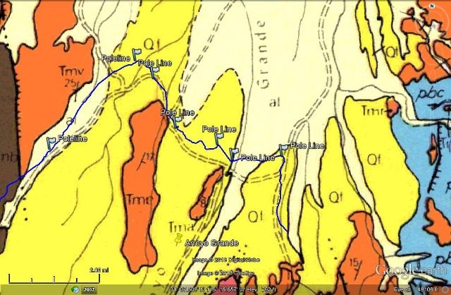
Then, I superemposed the 1971 Geology Map, which shows the Poleline road as 'abandonado'... and you can see the path line and the '71 map road are very close, less than a mile apart if not right over... pretty good for those cartographers!

First a High, overview look. See Cohabuzo Jcn. and La Ventana on Hwy. 5 (the typical start and end of the run).

Next are three sections of the road followed by the geology map overlay for each:


David K - 2-20-2013 at 11:02 PM

Who is up for searching for the lost grave of Melchior Diaz?

Ken Cooke - 2-21-2013 at 12:10 AM

Quote:
Originally posted by David K
Okay, so I already had several waypoints (GPS) of the Poleline Road from TW, Ken and Neal Johns... and those are shown as flags or push pins. I just today drew a path over the road as I viewed it on Google Earth. There was only some cloud cover around Basketball Hill, otherwise I could see the entire 1942 road. I began the path from west of the summit to east of Arroyo Grande.

The poleline road serviced the WWII telephone line to our radar station near San Felipe (Punta Diggs) from the phone lines already into Ensenada, from San Diego.

Then, I superemposed the 1971 Geology Map, which shows the Poleline road as 'abandonado'... and you can see the path line and the '71 map road are very close, less than a mile apart if not right over... pretty good for those cartographers!

First a High, overview look. See Cohabuzo Jcn. and La Ventana on Hwy. 5 (the typical start and end of the run).

Next are three sections of the road followed by the geology map overlay for each:


These are all great maps, David. Thank you for researching them. When a map reads, 'Abandoned Road' in Spanish, you know things can get interesting!:o

Taco de Baja - 2-21-2013 at 08:10 AM

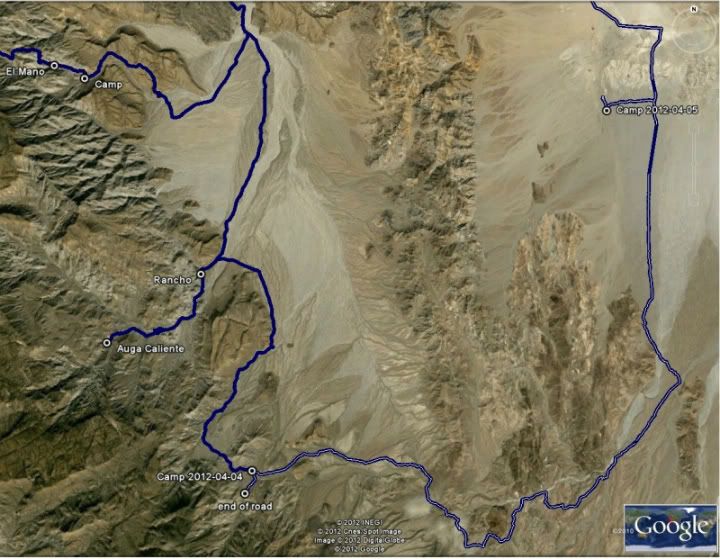
Here's our actual GPS track from our trip last April (with 3 Toyotas and no Jeeps :) )


Have fun.

Neal Johns - 2-21-2013 at 01:53 PM

Taco de Baja,
That was a great trip you were on. Been on all those roads, highly recommended for all backcountry lovers.
Ken Cooke, you really should go to Agua Caliente (above) as a side trip to the Pole Line Road.
Neal

Mexitron - 2-21-2013 at 02:26 PM

I agree Neal----it was a nice stopover between El Mano and the Pole Line road last March...very peaceful and nice taking a dip in the agua. We also hiked up Agua Caliente canyon up to around 3,500 feet, really nice area.

MICK - 2-25-2013 at 07:54 AM

I'm back. The road over the mountian seems to be the best way from 5 to there now due to the amazing amount of rain we got this year. the road thru the dunes is mostly no longer there and you have to pick your way thru. By going over the mountian and then north a little you can save a lot of time.
Mick

Ken Cooke - 2-26-2013 at 08:58 PM

This is sounding more and more interesting. I was in Tijuana last week giving my Jeep the "Baja Grande" treatment. Just a few more items that need attention before the Pole Line Run.

Luis installing my Currie 1" Motor Mount Lift

Ken Cooke - 3-22-2013 at 10:50 PM

Quote:
Originally posted by MICK
I'm back. The road over the mountian seems to be the best way from 5 to there now due to the amazing amount of rain we got this year. the road thru the dunes is mostly no longer there and you have to pick your way thru. By going over the mountian and then north a little you can save a lot of time.
Mick


How bad to you think the area has become? Were there flash floods that destroyed the roads??

MICK - 3-23-2013 at 07:24 AM

We drove over to El Palomar after the rains and it was not bad to there. the ranchers out there keep the roads passable to there so we will have no problems from here to there. below that I do not know but that's why we go.
Mick