BajaNomad

Adios, Guadalupe

elfbrewery - 4-13-2013 at 02:51 PM

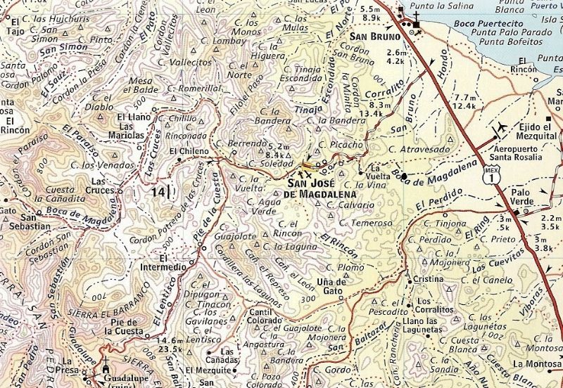
Two jeeps and a Toyota 4runner took off from La Posada Concepcion to retrace a route done two years ago that would take us along the Icehouse Road to Rancho Estanislao, Exmisión Guadalupe, the pass through the mountains, the canyon, past San Jerónimo (turnoff to Uña de Gato/San Borjitas) onward to San José de Magdalena and Highway 1. Leaving at 8 a.m. we planned to have lunch at the old mission site. The paved road out of Mulegé was very rough, but the dirt roads weren’t much better. The absence of the check dam (mile 16 in the Higginbottom book) was an indication as to why the roads were rough. The road now runs around the remains of the dam in the wash. Everyone agreed the climbs over the hills (someone should name these) were as bad as ever, but the previous good parts weren’t at all good. A man with a shovel at the top of the first hill waved us up and around. Thank you for clearing the road!

Once on the road to Rancho Estanislao, the endless crossing of the wash kept eyes down and not enjoying the scenery. Fortunately, it was lunchtime and we arrived at the signed turnoff to Exmisión Guadalupe. There are two ways to approach this ex-site. By taking the turnoff and passing through the gate, the track leads up to a chapel and the remains of an old rancho (where the mission used to be). The other approach, that provided us some shade, was to drive ahead a few car lengths along the road signed “La Presa.” There is a gate on the left and a path through some shade to a wash. After eating in the shade, we went down to the wash and followed it to the left towards the palm trees. You can find water catchments, the old rancho, lots of old palms and the chapel. To return, follow the wash to the fenceline to find your vehicles.

Refreshed and happy with our tour, we backed up and turned onto the road to San Jose de Magdalena. We now faced the climb over the mountains (2700’ pass) and eventual downward journey to town. This stretch was incredibly bad. Every time I think of it, I’m amazed. We drove over incredible washouts. The first jeep missed a shortcut around a crater, but eventually crawled back out. Then there was the “face plant” cut in the road. The angle entering this cut was “say your prayers” time. Another miracle granted. At this point I was thinking, “I’m glad we don’t have to come back this way.” More madness of rough road and then cement! When we made this trip in 2011 we had to wait near the canyon for cement to dry. They must have laid a lot more cement.

As we neared the canyon with remembrances of wet cement and the workers’ camp, we snaked down to where the road disappeared suddenly. That’s it, game over. I repeat, that’s it -- no road at all! I ran back to stop the other vehicles from coming closer because we were all going to have to turn around and wide areas along the road were not plentiful. Thank goodness for short wheelbases. We have to go back. We HAVE to go back. And we HAVE TO DRIVE EVERY STINKING INCH OF ROAD we came in on. Back over the cut (now you see a jeep, now you don’t, now you do). We got around the crater. We scrambled and spun and squirmed all the way back to the mission and then put our heads into getting home. We reached La Posada at 6 p.m. dusty, gritty, nerves on overdrive and totally amazed we had no accidents, broken down vehicles or injuries. I’m still amazed.

Mileage log (approximate) from start of Icehouse Road
15.8 check dam (remains), stay left
20.5 goat ranch at corner (Km 34), sharp right turn. Now we begin the climbs.
27.8 right turn onto Guadalupe road (Km 41?). Big sign.
30.6 Rancho Estanislao
39.45 first of two gates (place close these after passing through)
43.23 turnoff to Exmisión Guadalupe
47.2 road ends
if there were road, then
54.1 San Jerónimo (turnoff to Uña de Gato/San Borjitas)
62.8 West end of San Jose de Magdalena
72.3 Highway 1

BajaBlanca - 4-13-2013 at 03:54 PM

what a hard trip ... no time for photos?

David K - 4-14-2013 at 09:40 AM

This a great that you shared a rough ride report... Baja's wild roads are the best!

The Jesuit Spanish mission was the 8th in California, founded in 1720 by Padre Everado Helen at the Cochimí rancheria of Huasinapí. The mission was closed by the Dominicans in 1795 and the few remaining neophytes were moved to La Purísima.

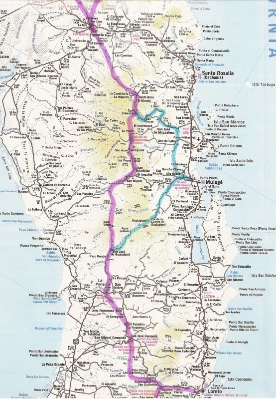
MULEGE to GUADALUPE TO SAN IGNACIO REGION:


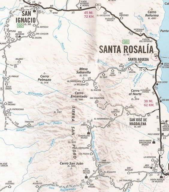
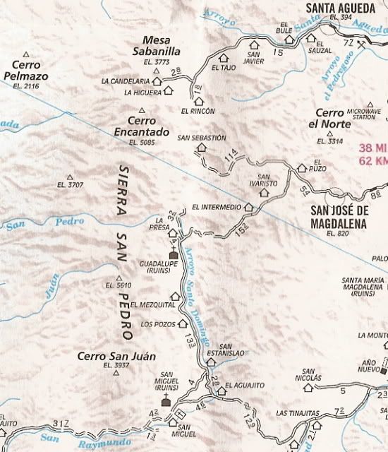
CLOSE UP OF GUADALUPE REGION:


San Miguel (to the south of Guadalupe) was a visita of Guadalupe, and only the graveyard remains to mark the chapel location.

Here is a close up topo map of the intended route out from Guadalupe (note Rancho Uña de Gato):


The El Camino Real...


KurtG - 4-14-2013 at 11:47 AM

If you attempt that road from the other end you will find a boulder the size of a small house blocking the road as it climbs the grade. There will be a lot of work before that road reopens but I have seen it in that state several times over the years and it always gets repaired. About 20 years ago I got as far as Estanislao and when I asked if I could get to Mision Guadalupe on my moto was told "not even on a burro."

Pix

elfbrewery - 4-14-2013 at 12:15 PM

If it's easy enough, I have some good pix.

David K - 5-12-2014 at 07:14 PM

Please send me your photos and I will post them for you (I think I u2u'd you before?)... Valuable data and old California history!

Here is the mission history and some photos: http://discoverbaja.wordpress.com/2014/01/10/the-spanish-mis...

Neal Johns - 5-12-2014 at 08:29 PM

I guess things have changed since I was there. Several years ago the road was in great shape. We explored M. Guadalupe and on the way out met the family that was living there broken down in the road. We supplied jacks and tools and they were very friendly.

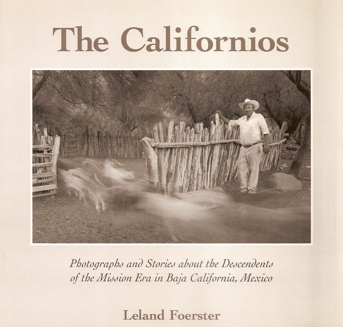
Anyone going near there should stop at Rancho El Mezquital. If the elders are still alive (Camerina and Antonio Villavicencio), you may meet their sons and daughters who populate the valley. A very formal picture of them is on page 40 of Leland Foerster's photo book The Californios. Camerina is a fantastic cook and Antonio is super friendly in spite of the very formal picture. :lol:

Oddly enough, Leland was there when I arrived. I had met him once before on the Anza Trail near Borrego Springs. Small world.
Neal

David K - 5-13-2014 at 03:10 PM

Quote:
Originally posted by Neal Johns
I guess things have changed since I was there. Several years ago the road was in great shape. We explored M. Guadalupe and on the way out met the family that was living there broken down in the road. We supplied jacks and tools and they were very friendly.

Anyone going near there should stop at Rancho El Mezquital. If the elders are still alive (Camerina and Antonio Villavicencio), you may meet their sons and daughters who populate the valley. A very formal picture of them is on page 40 of Leland Foerster's photo book The Californios. Camerina is a fantastic cook and Antonio is super friendly in spite of the very formal picture. :lol:

Oddly enough, Leland was there when I arrived. I had met him once before on the Anza Trail near Borrego Springs. Small world.
Neal


Excellent B&W Photos...