BajaNomad

road along east side of laguna salada

cercidium - 5-4-2013 at 04:23 PM

first time posting, long time traveler. howdy!

i'm wondering if anyone can comment on the road conditions heading south from the 2 traveling along the east side of laguna salada, against the sierra cucapas? i'm planning a trip in june to reach the pools(??) at the low point, approx 10-15 miles from pavement and welcome any comments/experience with this area. i see a lot of tracks on google going along the base of the bajada but have never explored this area in the past. any advice / trip experience is welcome!

i've traveled in all seasons throughout the sonoran desert, summer and mexico included. i'm well aware of the temps and general driving conditions, fyi.

this is a great forum to explore!

woody with a view - 5-4-2013 at 04:26 PM

welcome to the jungle!

stand by for info overload......

Barry A. - 5-4-2013 at 04:33 PM

"east side" of the Laguna Salada??-----nowTHAT is going to be interesting. Many times on the west side (when we lived in El Centro), but never the east side. Hope you get some responders---------it's all very interesting and I love to hear about new places in Baja.

Barry

TMW - 5-4-2013 at 06:25 PM

The last time I rode down the east side was for the 1990 Baja 1000 race. I think CODE has used the east side for some races. The SCORE race came down the east side and went thru a canyon that came out to an access road that went to hwy 5 at about KM40. But there is a parallel road that joins the road back over the mtns from hwy 5 at KM49 to Laguna Salada. At that point there is a road that sides the mtn around the south end back to hwy 5. Never heard of any pools anywhere in the area, but who knows.

David K - 5-4-2013 at 07:02 PM

Pools? There is a sulfur mine, but the only pools I can think of is the hot springs on the west side of Laguna Salada... ie. Guadalupe Canyon, Palomar, etc.

MMc - 5-4-2013 at 07:29 PM

Maps to follow:lol::lol::lol: Sounds like a fun trip.

one route

John M - 5-5-2013 at 10:36 AM

So many years ago I cannot recall details, but we left Highway 5 at about El Medanito, just a little north of Rio Hardy (GPS 32 10.696/ 115 18.879 on google earth) - wound up and through the Sierra el Mayor, joining the east side of Laguna Salada at about (GPS 32 7.758/ 115 25.680 on google earth) then continued south along the edge of the salada, rejoining Highway 5 near Pozo el Coyote. The route is pretty easy to see on google earth zoomed in.

We were working a Score checkpoint and followed the above route after the race as a sweep vehicle looking for stranded racers. If someone has race maps back into the early '80s it would show as race course.

Not much along your proposed east of Salada trip, but maybe could be used as an exit route if you work your way south from Highway 2D.

I could send along some waypoints if you do not do google earth but have GPS.

David K not doubt has mapped this area...David??

John M

David K - 5-5-2013 at 11:05 AM

I am on my phone at a softball game. When I am home I will see what I can do.

Mexitron - 5-5-2013 at 11:12 AM

Looks like a good road on google maps---and looks like vegetation denoting at least saline wet spots in several spots. Never noticed the shoreline terraces along that side---evidently from the occasional flooding.

cercidium - 5-5-2013 at 04:55 PM

thanks to all for the input and advice! upon re-discovering google earth (don't ask) i see that the destination is labeled pozo del tules, somewhat north of the route josh m recommended. if anyone has info about this area i'd love to hear it.

likewise, if david k has historic maps from score events i'd love to see those too.

new trips get more exciting by the minute!

Mexitron - 5-5-2013 at 05:10 PM

BTW---love the moniker, Cercidium is one of my favorite trees!

David K - 5-6-2013 at 09:03 AM

Quote:
Originally posted by cercidium
thanks to all for the input and advice! upon re-discovering google earth (don't ask) i see that the destination is labeled pozo del tules, somewhat north of the route josh m recommended. if anyone has info about this area i'd love to hear it.

likewise, if david k has historic maps from score events i'd love to see those too.

new trips get more exciting by the minute!


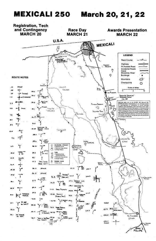
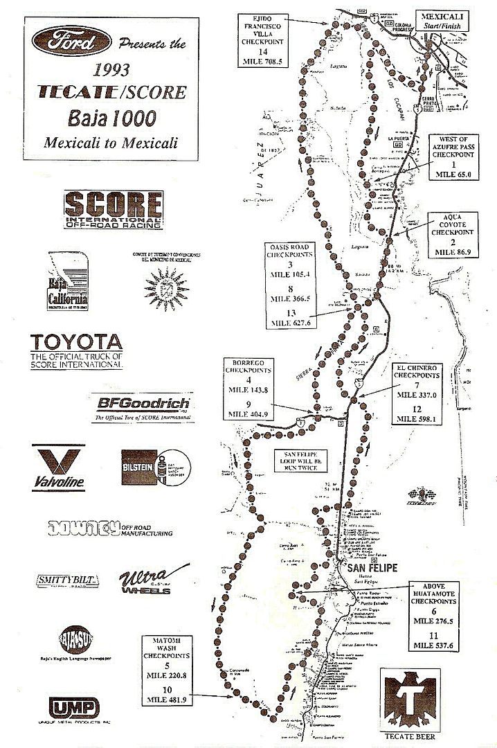
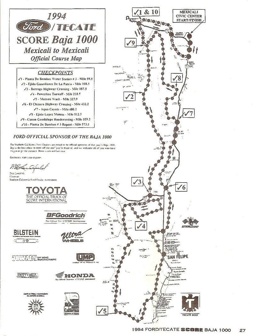
Welcome to Baja Nomad! Here are some online maps that show when a race went along the east side of Laguna Salada (from http://www.murdocknav.com/racingmaps.htm ):

1981 Mexicali 250:


1993 Baja 1000:


1994 Baja 1000:


2007 CODE Mexicali 250:

2007 CODE Night Race:

2007 CODE Mexicana Logisics 300:

2007 CODE Race Ready 275:

2008 CODE Mexicali 500:

Many more CODE races along Laguna Salada...

See them at http://www.murdocknav.com/racingmaps.htm


EDIT: As it seems the pdf or jpg map links didn't work, I removed them but left the race name. These are all the races I know of that ran along the east side of Laguna Salada... No doubt there are many more. Baja Nomad member 'Tunaeater' races CODE and might have some maps to add?

[Edited on 5-7-2013 by David K]

cercidium - 5-7-2013 at 03:31 PM

thanks david k! the links are 'forbidden'. do i need to be a registered user on murdocknav?

DENNIS - 5-7-2013 at 03:42 PM

Quote:
Originally posted by cercidium
thanks david k! the links are 'forbidden'. do i need to be a registered user on murdocknav?


Forbidden for me as well, but maybe you can get into it through DK's top link:

http://www.murdocknav.com/racingmaps.htm ):


.

[Edited on 5-7-2013 by DENNIS]

David K - 5-7-2013 at 03:53 PM

Interesting... I just click on the link and the map appears for me... ? Let me see if I can show them another way... You guys do see 3 maps above, in addition to the links, yes?

DENNIS - 5-7-2013 at 03:55 PM

Quote:
Originally posted by David K
... You guys do see 3 maps above, in addition to the links, yes?


I don't.


.

[Edited on 5-7-2013 by DENNIS]

David K - 5-7-2013 at 04:18 PM

Very weird... Okay, I scanned the 1993 Baja 1000 map... Mexicali to Matomi Wash and back to Mexicali, with a double loop of the southern half:


1981 Mexicali 250:


1994 Baja 1000:


[Edited on 5-7-2013 by David K]

DENNIS - 5-7-2013 at 04:48 PM

Like I mentioned....I can get to this map through here:


http://www.murdocknav.com/racingmaps.htm ):


.

[Edited on 5-7-2013 by DENNIS]

David K - 5-7-2013 at 04:51 PM

OK, I just edited my first set of links to race maps, and show 3 races that went along the west side of the Laguna Salada basin... Good that the master link to the web site works for you guys. Thanks Dennis for the view from your end.

cercidium - 5-9-2013 at 07:24 AM

thanks to both dennis and david k for helping out, it's much appreciated. the maps appear as expected now... and they're cool historic documents too!

TMW - 5-20-2013 at 03:58 PM

Did you find the place you were looking for?

Neal Johns - 5-20-2013 at 05:34 PM

I led a group of DesertExplorers.org over the east road over a decade ago and there was no problems at all. The short, heavy vegetated parts were narrow but not marshy. Then the road finally went through the mountains to Hwy. 5. We were going south.

Caution: Do not run it when pre-runners are doing their thing, we stopped our group in a heavy vegetated area for a pee stop, and a pre-runner came zooming along and had to eat a lot of weeds and brush to keep from rear-ending us. Our fault for not knowing the race course was there. He stopped and apologized profusely. That shows me a lot of class.
Neal

cercidium - 5-21-2013 at 01:32 PM

thanks for the additional information neal. the trip is planned for mid june (to answer tw's question) and i'm happy to have so much additional information from seasoned salada minds. looking forward to checking out the area!

scott