BajaNomad

Malpaso del Infierno, Journey of the Flame

philodog - 5-11-2013 at 01:01 PM

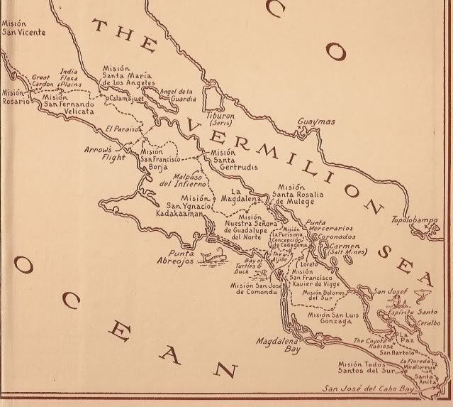
I just finished reading Journey of the Flame, a fantastic book of a trip through Baja in 1810. It mentions Malpaso del Infierno as an incredibly hard part of the route to negotiate and I was wondering where this is. The map in the book shows it between Mission San Gertrudis and San Ignacio and is well away from the current highway. A Google search turns up nothing of interest.

DavidE - 5-11-2013 at 02:05 PM

It is located within the area of San Francisco de Sierra and is remote enough to have earned the respect of today's venturing explorers searching pepitas. Various prospectors have confirmed what I suspected for decades, microclimates can play hell with so called climate averages on the peninsula.

As a mini-example leaving Mulege headed south on Mex 1, between the gasolinera and crest of the cumbre where you can see the water, there is a tiny valley that at times can be 8 - 10F warmer than north or south of it.

As a guess, perhaps such a small valley earned the ire of early explorers. Looking for obsidian, I have encountered ravines to the west of Las Tres Virgines full of cinnabar colored lava that were simply unbearable. One such mini inferno pegged a small thermometer higher than 120F

David K - 5-11-2013 at 04:35 PM

Very good amigo... Indeed it is on the eastern branch of El Camino Real just north of San Ignacio. More details when I get home... The book has been discussed here, but in the historic interests and literature forum... where
this may end up.? ;)

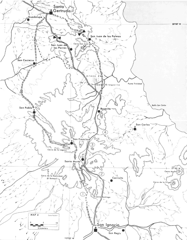
On Harry Crosby's 1977 El Camino Real maps:

David K - 5-11-2013 at 05:22 PM

Just north of San Ignacio... and south of Santa Marta, note the #2, in a circle... That is the location of 'Malpaso del Infierno'... where the Camino Real traveled in a canyon of Arroyo El Infierno ('Hell'). On the 2009 Baja Almanac, Map 12, A-6. The 2003 Baja Almanac, it is on Map 32, B-1 and A-1.


Here is the map from the Journey of the Flame novel:


The map is not exact, but is pretty good to help visualize the Camino Real and missions in 1810 (the whole story, as our 2012 'Old Missions' book tells it, not just half of 'California')... El Infierno is much closer to San Ignacio than shown.. and El Paraiso is actually south of San Borja, not north as shown.


A 2008 post by BajaAmy: http://forums.bajanomad.com/viewthread.php?tid=35936


[Edited on 5-12-2013 by David K]

BajaNomad - 5-11-2013 at 06:08 PM

Just because you mentioned "Journey of the Flame":

http://forums.bajanomad.com/viewthread.php?tid=35936

philodog - 5-11-2013 at 06:22 PM

Thanks David. Unfortunately only the last link worked.

Osprey - 5-11-2013 at 07:24 PM

Many a night on the patio behind the little tienda Jimmy and I would chew the fat for want of a better thing to do and when we couldn't see each other to demonstrate a point here and there with our hands or eyebrows he would call for the lamp. With the bugs now happily buzzing all around the table we talked for hours about the old Red Head. Jimmy drank beer but I brought Hornitos and limes and it was just because he was older and more used up than me was I still talkin' when he went out and down like a new calf near the tank.

Together we walked the Baja with early ones long before Graham and Younghusband and others but just in our whiskey dreams. I still do it. Hope Jimmy says the same.

David K - 5-12-2013 at 01:25 AM

Quote:
Originally posted by philodog
Thanks David. Unfortunately only the last link worked.


Weird... well just do what I did and use Nomad search at the top left. I will try and fix the links later. Mainly I wanted to answer your question with the Camino Real map.

Edit: Seems that Doug vaporized a couple of those classic Nomad threads about the book, a new search fails to show them...

Bajatripper - 5-12-2013 at 11:53 PM

Quote:
Originally posted by philodog
I just finished reading Journey of the Flame, a fantastic book of a trip through Baja in 1810. It mentions Malpaso del Infierno as an incredibly hard part of the route to negotiate and I was wondering where this is. The map in the book shows it between Mission San Gertrudis and San Ignacio and is well away from the current highway. A Google search turns up nothing of interest.


You do know this is a work of fiction, right?

durrelllrobert - 5-13-2013 at 09:51 AM

Quote:
Originally posted by David K
Just north of San Ignacio... and south of Santa Marta, note the #2, in a circle... That is the location of 'Malpaso del Infierno'... where the Camino Real traveled in a canyon of Arroyo El Infierno ('Hell'). On the 2009 Baja Almanac, Map 12, A-6. The 2003 Baja Almanac, it is on Map 32, B-1 and A-1.


Here is the map from the Journey of the Flame novel:


[Edited on 5-12-2013 by David K]

The Vermilion Sea? Never heard or saw it called that before.

DavidE - 5-13-2013 at 11:54 AM

The poor gulf has had romanticized tags laid on it for many years.

Gulf - A large area of a sea or ocean partially enclosed by land, especially a long landlocked portion of sea opening through a strait. (Gulf of Mexico, Gulf of
California).

Ray Cannon may have been one of the early visitors who popularized the term "Sea of Cortez"

History Excerpt
____________________________________________________________

"n April of 1535 Cortés, probably on the basis of the reports from the, ill-fated Ximénez expedition, sailed directly to the southeastern tip of the Baja Peninsula. (See Fig. 1) At Puerto de la Paz* (Santa Cruz, as he called it), he attempted to establish a colony. From here he sent out a number of land expeditions, one of which quite possibly reached the west side of the peninsula, around latitude 25o. The expedition had been on Baja for some months when Francisco de Ulloa arrived at La Paz, or Santa Cruz, with letters to Cortés from Viceroy Antonio de Mendoza. When the Audiencia had ordered against Nuño De Guzmán's new voyage it had also forbidden Cortés to make a voyage. The recalcitrant Cortés, ignoring this decision, had proceeded to place a colony at La Paz. The letters were presumably orders directing Cortés to return and to answer charges.

At the La Paz colony everything had gone wrong. The settlement had been a failure from the beginning. The greatest problem was logistics. In an attempt to save the situation, several trips had been made across the Gulf. These were mainly directed toward obtaining supplies and transporting colonists to La Paz. The hazards of such a voyage were great. On the second trip one ship was wrecked and another, commanded by Hernando de Grijalva, was unable to return to Baja. When the pilot of Cortés' vessel was killed during a storm, Cortés took the wheel himself and managed to bring the vessel into La Paz. Upon his return he found twenty-three of the colonists dead of starvation and the survivors cursing his name. With the remaining vessel he returned to the mainland seeking relief. By 1536 it became apparent to all that the colony was a failure, and Cortés was undoubtedly glad to be recalled. Upon receiving the letters he gave command of the colony to Ulloa and hastened to Acapulco. It was not long before Ulloa returned with the remnants of the colony"

David K - 5-14-2013 at 08:51 AM

Quote:
Originally posted by durrelllrobert
Quote:
Originally posted by David K
Just north of San Ignacio... and south of Santa Marta, note the #2, in a circle... That is the location of 'Malpaso del Infierno'... where the Camino Real traveled in a canyon of Arroyo El Infierno ('Hell'). On the 2009 Baja Almanac, Map 12, A-6. The 2003 Baja Almanac, it is on Map 32, B-1 and A-1.


Here is the map from the Journey of the Flame novel:


[Edited on 5-12-2013 by David K]

The Vermilion Sea? Never heard or saw it called that before.


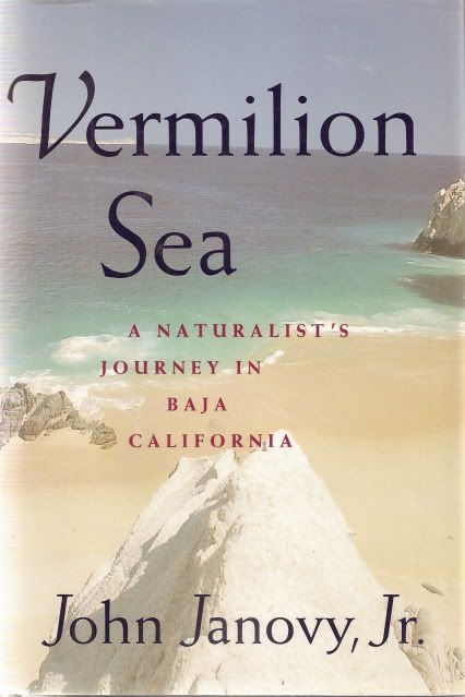
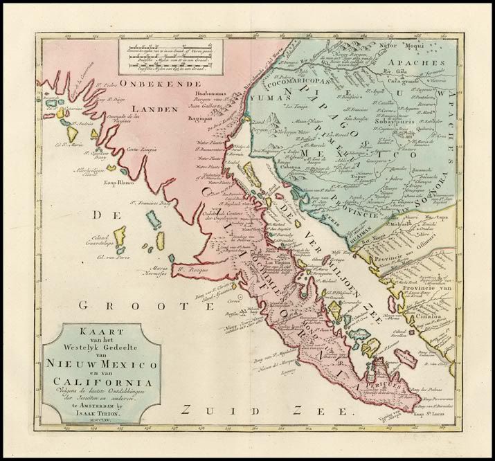
It isn't as common as the names, 'California Sea' or 'Cortez Sea', but similar to the name 'Red Sea of Cortez'... and there was a book published in 1992 called: 'Vermilion Sea, A Naturalist's Journey in Baja California' by John Janovy, Jr.


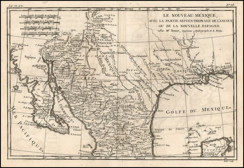
Here's one map from 1780:


Here's another, from 1765:


David K - 5-14-2013 at 09:03 AM

Quote:
Originally posted by DavidE
The poor gulf has had romanticized tags laid on it for many years.

Gulf - A large area of a sea or ocean partially enclosed by land, especially a long landlocked portion of sea opening through a strait. (Gulf of Mexico, Gulf of
California).

Ray Cannon may have been one of the early visitors who popularized the term "Sea of Cortez"

History Excerpt
____________________________________________________________

"n April of 1535 Cortés, probably on the basis of the reports from the, ill-fated Ximénez expedition, sailed directly to the southeastern tip of the Baja Peninsula. (See Fig. 1) At Puerto de la Paz* (Santa Cruz, as he called it), he attempted to establish a colony. From here he sent out a number of land expeditions, one of which quite possibly reached the west side of the peninsula, around latitude 25o. The expedition had been on Baja for some months when Francisco de Ulloa arrived at La Paz, or Santa Cruz, with letters to Cortés from Viceroy Antonio de Mendoza. When the Audiencia had ordered against Nuño De Guzmán's new voyage it had also forbidden Cortés to make a voyage. The recalcitrant Cortés, ignoring this decision, had proceeded to place a colony at La Paz. The letters were presumably orders directing Cortés to return and to answer charges.

At the La Paz colony everything had gone wrong. The settlement had been a failure from the beginning. The greatest problem was logistics. In an attempt to save the situation, several trips had been made across the Gulf. These were mainly directed toward obtaining supplies and transporting colonists to La Paz. The hazards of such a voyage were great. On the second trip one ship was wrecked and another, commanded by Hernando de Grijalva, was unable to return to Baja. When the pilot of Cortés' vessel was killed during a storm, Cortés took the wheel himself and managed to bring the vessel into La Paz. Upon his return he found twenty-three of the colonists dead of starvation and the survivors cursing his name. With the remaining vessel he returned to the mainland seeking relief. By 1536 it became apparent to all that the colony was a failure, and Cortés was undoubtedly glad to be recalled. Upon receiving the letters he gave command of the colony to Ulloa and hastened to Acapulco. It was not long before Ulloa returned with the remnants of the colony"


Ulloa was the first of many to actually prove California was not an island... yet, maps kept depicting it an island for another 200 years. Kino, Melchior Diaz, and others failed to convince politicians and cartographers of the peninsular nature of California in the 1500's and 1600's.

Jesuit Padre Consag's canoe expedition of the upper gulf in 1746 seemed to finally rest the case and the Jesuits began to build missions and roads to connect their peninsula missions (from San Jose del Cabo north to San Ignacio) with their missions in Sonora...
=======================================================

More on Ulloa from Wikipedia:

Francisco de Ulloa (died 1540) was a Spanish explorer who explored the west coast of present-day Mexico under the commission of Hernán Cortés. The reports of his expeditions along the Baja California peninsula are credited with being influential in the perpetuation of the 17th century cartographic misconception of the existence of the Island of California.

It is not known whether Ulloa accompanied Cortés on his first expedition to the New Spain. By the account of Bernal Díaz del Castillo, he came to Mexico later while transporting letters to Cortés from his wife. According to some early historians, Ulloa was influential in helping subdue the Aztec capital Tenochtitlan by naval power.

In 1539, at the private expense of Cortés, he embarked on an expedition in three small vessels, sailing north from Acapulco to explore the Pacific Coast, and to seek the mythical Strait of Anián that supposedly led to the Gulf of St. Lawrence, proving the existence of the Northwest Passage. The expedition left on July 8 sailing northwards along the coast and reaching the Gulf of California six weeks later. Ulloa named it the "Sea of Cortés" in honor of his patron. When one of his ships was lost in a storm Ulloa paused to repair the other two ships, and then resumed his voyage on September 12, eventually reaching the head of the Gulf.
Unable to find the Strait of Anián, Ulloa turned south and sailed along the eastern coast of the Baja California peninsula, landing at the Bay of La Paz. After taking on supplies of wood and water Ulloa rounded the tip of the peninsula with great difficulty and sailed northward along the western shore in the Pacific Ocean.

The progress of his small ships was hampered by the fierce winds and high seas he encountered, eventually forcing him to turn back to New Spain. The voyage eventually reached 28 degrees north near the Isla de Cedros.

Although his discoveries lent support to the fact that Baja California was a peninsula, his reports were used to create maps depicting California as an island. According to Díaz del Castillo, Ulloa was stabbed to death by a sailor after his return in 1540. By other accounts, his ship was lost without a trace during the return voyage from Baja California. Supposedly his ship was swept inland with a tsunami, later becoming known as the Lost Ship of the Desert.


[Edited on 5-14-2013 by David K]

El Infierno

John M - 5-15-2013 at 12:30 PM

There is substantial description of this route in Crosby's The Kings Highway in Baja California In addition to his fine word picture, Crosby cites (and quotes from) an account written by William M. Gabb published in Resources of the Pacific Slope; pp 62-122.

A brief passage from Crosby upon his reaching the portezuelo, or high pass between hills: As I stood at the portezuelo and gazed out on that tranquil scene, once again I had the strange sensation of having gone back in time. Lizasoain [Fr. Ignacio Lizasoain S.J.] had stopped to eat in Santa Marta and Serra h ad slept there. Both had to have stood on the very spot where I was standing and they must have looked out on almost exactly the same picture. Nothing had disturbed Santa Marta since their time, and the land, wrapped in its sheltering mountains, preserved the aura of centuries past.

Though Crosby and Gabb make much of this section of the El Camino, Serra hardly seems phased. Serra's diary entry reads: "On the 18th, in the morning, I set forth from San Ygnacio; and as I failed to waken early, and the day was burning, I could not make the regular day's march. I made noon, much heated, in a Cave which they say is called [Cave] of la Magdalena; and in the evening arrived at the place which is called Santa Marta, where I slept on the earth."

I've tried to add a photo but photobucket is not cooperating.

John M


[Edited on 5-15-2013 by John M]

[Edited on 5-15-2013 by John M]

Mexitron - 5-15-2013 at 12:40 PM

Quote:
Originally posted by Bajatripper
Quote:
Originally posted by philodog
I just finished reading Journey of the Flame, a fantastic book of a trip through Baja in 1810. It mentions Malpaso del Infierno as an incredibly hard part of the route to negotiate and I was wondering where this is. The map in the book shows it between Mission San Gertrudis and San Ignacio and is well away from the current highway. A Google search turns up nothing of interest.


You do know this is a work of fiction, right?


Fiction, but with a lot of history intertwined...aka Michener.

DENNIS - 5-15-2013 at 12:49 PM

Quote:
Originally posted by Mexitron
Fiction, but with a lot of history intertwined...aka Michener.


Yeah....I liked the part when the kid invented the hand grenade while he was coming up the Peninsula and ran into that old reprobate who wanted to turn him into a jailhouse punk, so the kid put a river rock, swollen with water, into the fire and it exploded, blowing hell out of the old creep, and he split with his honor intact.

David K - 5-16-2013 at 06:52 AM

Quote:
Originally posted by John M
There is substantial description of this route in Crosby's The Kings Highway in Baja California In addition to his fine word picture, Crosby cites (and quotes from) an account written by William M. Gabb published in Resources of the Pacific Slope; pp 62-122.

A brief passage from Crosby upon his reaching the portezuelo, or high pass between hills: As I stood at the portezuelo and gazed out on that tranquil scene, once again I had the strange sensation of having gone back in time. Lizasoain [Fr. Ignacio Lizasoain S.J.] had stopped to eat in Santa Marta and Serra h ad slept there. Both had to have stood on the very spot where I was standing and they must have looked out on almost exactly the same picture. Nothing had disturbed Santa Marta since their time, and the land, wrapped in its sheltering mountains, preserved the aura of centuries past.

Though Crosby and Gabb make much of this section of the El Camino, Serra hardly seems phased. Serra's diary entry reads: "On the 18th, in the morning, I set forth from San Ygnacio; and as I failed to waken early, and the day was burning, I could not make the regular day's march. I made noon, much heated, in a Cave which they say is called [Cave] of la Magdalena; and in the evening arrived at the place which is called Santa Marta, where I slept on the earth."

I've tried to add a photo but photobucket is not cooperating.

John M


Let me know if I can help!

Several Crosby El Camino Real photos are on this web site: https://www.sandiegohistory.org/journal/77winter/bajaimages....

[Edited on 5-16-2013 by David K]

From Harry Crosby, 1970's

David K - 5-16-2013 at 07:16 AM


Entering El Infierno (between Carrizito and Santa Marta, Map 4) The bizarre regional botany of Baja California is well represented by torote (Bursera microphylla) left, and cardón (Pachycereus pringlei), right, flanking a well-worn piece of El Camino Real.


El Infierno (between Carrizito and Santa Marta, Map 4) The old mission trail had to traverse a number of rocky gorges of which El Infierno emerges from the literature as perhaps the most infamous.

Bajatripper - 5-17-2013 at 10:43 PM

Quote:


Though Crosby and Gabb make much of this section of the El Camino, Serra hardly seems phased. Serra's diary entry reads: "On the 18th, in the morning, I set forth from San Ygnacio; and as I failed to waken early, and the day was burning, I could not make the regular day's march. I made noon, much heated, in a Cave which they say is called [Cave] of la Magdalena; and in the evening arrived at the place which is called Santa Marta, where I slept on the earth."

I've tried to add a photo but photobucket is not cooperating.

John M


As for the disparity between how Crosby and Serra saw the grade, keep in mind that Serra travelled it just after the Jesuits had left the peninsula, so it had been well-maintained until then. He was also a man of those times, when there weren't many roads anywhere in Mexico, so such grades were somewhat common in the day. Crosby, on the other hand, visited it after it had been neglected for some 60 years and furthermore came down from California in the 1960s and was using that urban jungle as his reference point for judging such things.

Baja Bucko - 5-18-2013 at 08:38 AM

I have ridden (mule) El Infierno many times in the SSF and much of ECR in this range, also all of it from San Casimero north to almost El Rosario; south of Ian Ignacio from Guajademi to San Javier.

I don't have time at this moment but will try to get back regarding many questions here. By far with the problems age, lack of use and chubascos bring, El Paraiso is one of the worst parts.......(Sta Gertrudis to San Borja....even Harry had a hiccup or two there.

Barry A. - 5-18-2013 at 11:27 AM

THE VERMILLION SEA--------In the good ol days before dams, the Colorado River disgorged into the Sea of Cortez in flood, carrying tons of fine red earth from it's upper reaches suspended in the water-------I always suspected that the name "Vermillion Sea" came from the Sea of Cortez being turned red with that suspended mud/silt during Spring floods, at least in it's northern portion.

Just my theory, as I don't recall anybody putting this idea forward.

Barry

DENNIS - 5-18-2013 at 11:32 AM

Quote:
Originally posted by Barry A.
THE VERMILLION SEA--------In the good ol days before dams, the Colorado River disgorged into the Sea of Cortez in flood, carrying tons of fine red earth from it's upper reaches suspended in the water-------I always suspected that the name "Vermillion Sea" came from the Sea of Cortez being turned red with that suspended mud/silt during Spring floods, at least in it's northern portion.

Just my theory, as I don't recall anybody putting this idea forward.

Barry


Yeah....I'll buy that, Barry. Also, the word Colorado meaning "Red" gives meaning to the word Roxo, which is probably another way to spell Rojo. [did Steve already say this?]

willardguy - 5-18-2013 at 12:16 PM

I always thought "vermilion sea" came from the plankton bloom in soc?

Barry A. - 5-18-2013 at 12:20 PM

Quote:
Originally posted by willardguy
I always thought "vermilion sea" came from the plankton bloom in soc?


------that's as good, or a better theory than mine, willardguy.

I truly have no idea. In all my years I have never seen a "plankton bloom" in the SOC, but they probably happen. I certainly saw several of them in the Pacific off San Diego, years ago.

Barry

DENNIS - 5-18-2013 at 12:26 PM

There was a Red Tide [is that a Plankton bloom?] that came by the coast near La Bufadora ten or so years back that suffocated 500 ton of Tuna in the pens. They had to tow the pens outside and dump them.
Never could understand how they could let that happen. It's not like a Red Tide can sneak up on you. They should have released the fish when they were alive.

Barry A. - 5-18-2013 at 12:27 PM

"Red tide"--------"plankton bloom"-------I think they are the same, Dennis. Yur point is well taken.

Barry

David K - 5-18-2013 at 03:18 PM

Indeed, history give the red sea credit to the Colorado (Red) River dumping sediment into the gulf. Francisco de Ulloa was the first Spaniard to sail the the length of the gulf... Here's a bit from Wikipedia:
=============================================================

The Gulf of California (also known as the Sea of Cortez or Sea of Cortés or Vermilion Sea; locally known in the Spanish language as Mar de Cortés or Mar Bermejo or Golfo de California) is a body of water that separates the Baja California Peninsula from the Mexican mainland. It is bordered by the states of Baja California, Baja California Sur, Sonora, and Sinaloa with a coastline of approximately 4,000 km (2,500 mi). Rivers which flow into the Gulf of California include the Colorado, Fuerte, Mayo, Sinaloa, Sonora, and the Yaqui. The gulf's surface area is about 160,000 km2 (62,000 sq mi).

-------------------------------------------------------------------------------------------------------

In 1539, at the private expense of Cortés, he (Ulloa) embarked on an expedition in three small vessels, sailing north from Acapulco to explore the Pacific Coast, and to seek the mythical Strait of Anián that supposedly led to the Gulf of St. Lawrence, proving the existence of the Northwest Passage.

The expedition left on July 8 sailing northwards along the coast and reaching the Gulf of California six weeks later. Ulloa named it the "Sea of Cortés" in honor of his patron. When one of his ships was lost in a storm Ulloa paused to repair the other two ships, and then resumed his voyage on September 12, eventually reaching the head of the Gulf.

Unable to find the Strait of Anián, Ulloa turned south and sailed along the eastern coast of the Baja California peninsula, landing at the Bay of La Paz. After taking on supplies of wood and water Ulloa rounded the tip of the peninsula with great difficulty and sailed northward along the western shore in the Pacific Ocean.

The progress of his small ships was hampered by the fierce winds and high seas he encountered, eventually forcing him to turn back to New Spain. The voyage eventually reached 28 degrees north near the Isla de Cedros.
Although his discoveries lent support to the fact that Baja California was a peninsula, his reports were used to create maps depicting California as an island. According to Díaz del Castillo, Ulloa was stabbed to death by a sailor after his return in 1540. By other accounts, his ship was lost without a trace during the return voyage from Baja California. Supposedly his ship was swept inland with a tsunami, later becoming known as the Lost Ship of the Desert.

[Edited on 5-18-2013 by David K]