BajaNomad

Mike's Sky Ranch to PN Sierra San Pedro Martir

56MM# - 5-16-2013 at 03:07 PM

Does anyone know if there's a 4WD road from Mike's to PN (not Mike's to Meling Ranch)? The Baja Almanac indicates no, but Google Maps seems to show trails that connect the two. Perhaps up El Hulco to Rancho Nuevo (Baja Almanac p. 4, coordinates L5 & M5).

Regarding the Meling Ranch route, it was impassable to 4WD when I was down there two years ago. Coming from Meling Ranch, about two miles east of El Coyote the road gets too rough.

Lastly, has anyone else observed that some of the roads within PN that were open 10 or more years ago are now closed?

David K - 5-16-2013 at 03:53 PM

Nope... the last people to try recently were never heard from again! (no joke)

The road that was once shown in the AAA map to get to the observatory was a logging trail from 80 years ago maybe!? It goes by 'Corral de Sam' and you can see it on Google Earth. However, nearby b&b operator 'AstroBaja' (Rancho La Concepcion renamed Baja Dark Skies Inn) seriously advises not to try, saying they risk arrest for using an officially 'closed road'!?!
This is going up from the point called 'San Pedro (Ab)' at L5, Pg. 4. Rancho Concepcion is also not shown correctly in the Almanac... It is just south of that San Pedro on the arroyo labled Los Pinos... not down next to the observatory highway.

Interesting abbreviation PN...? Parque Nacional, yes?


[Edited on 5-17-2013 by David K]

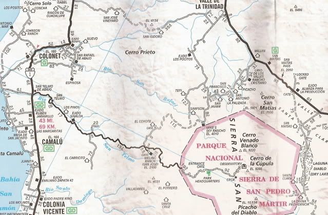
Some maps...

David K - 5-16-2013 at 05:53 PM


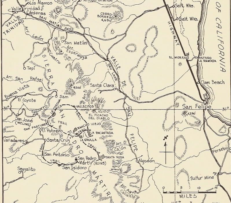
1962 Gulick Map (Lower California Guidebook)


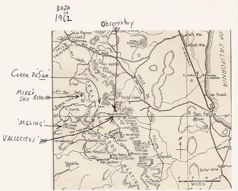
1962 map with notes added.


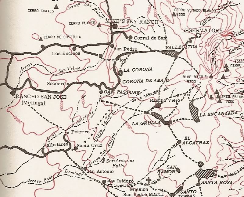
1972 map.


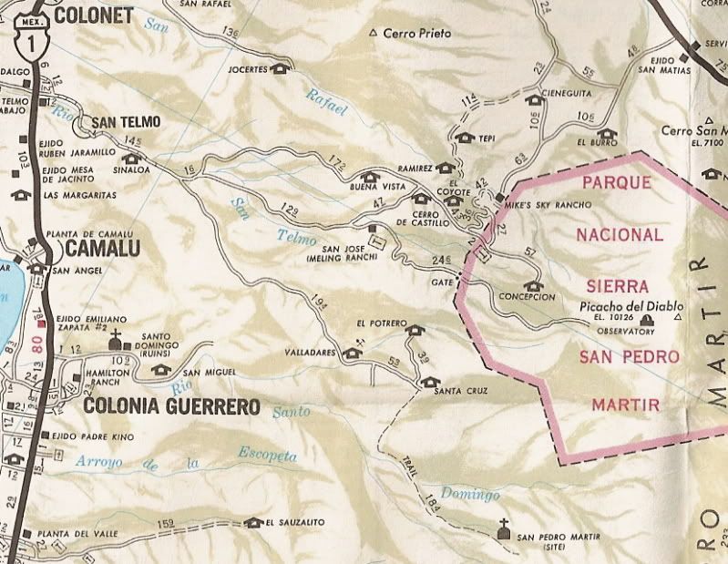
1974 AAA Map.


1978 AAA Map.


2003 Baja Almanac


2007 AAA Map

56MM# - 5-16-2013 at 09:30 PM

Thanks Mike...great collection of maps. Would have loved to attempt a drive up to PN via a route other than the now-paved observatory road.

There are few things in life more enjoyable than discovering an old road in Baja, then seeing how far one can get. One of the best days of my life was doing just that on an old road east of Nueva York in 2001. Back then it was slow going in a 4WD with lots of frequent stops, trail finding and Arizona pinstripes. Today, the road has been reopened for ranching and can be done in a 2WD pickup.

Yes, PN stands for Parque Nacional. I have heard this park referred to as "parque nal" at Meling Ranch.

David K - 5-16-2013 at 09:44 PM

Quote:
Originally posted by 56MM#
Thanks Mike...great collection of maps. Would have loved to attempt a drive up to PN via a route other than the now-paved observatory road.

There are few things in life more enjoyable than discovering an old road in Baja, then seeing how far one can get. One of the best days of my life was doing just that on an old road east of Nueva York in 2001. Back then it was slow going in a 4WD with lots of frequent stops, trail finding and Arizona pinstripes. Today, the road has been reopened for ranching and can be done in a 2WD pickup.

Yes, PN stands for Parque Nacional. I have heard this park referred to as "parque nal" at Meling Ranch.


Your welcome (it's Dave/ David ;) )

Finding new and old roads (and trails) is a great thing about Baja. Seeing a road built in the 1700's is way cool to me (El Camino Real), as well!

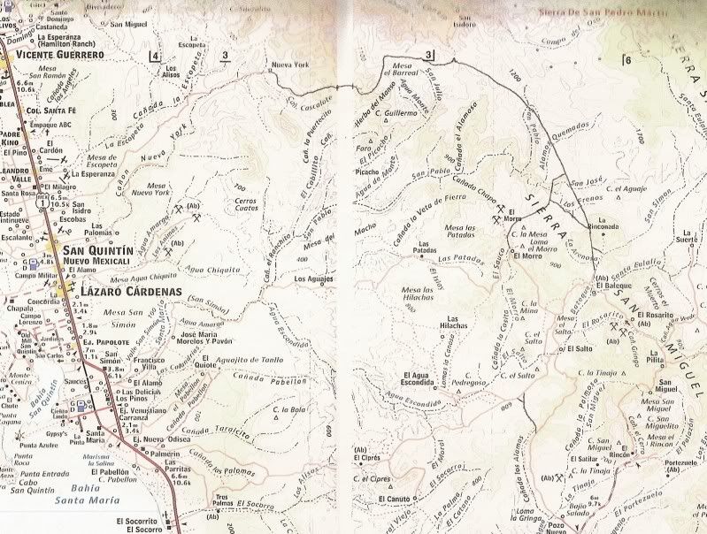
That road up to Nueva York from north of San Quintin now continues around the foothills and goes south to meet Hwy. 1, east of El Rosario. It provides a short route to hike to San Isidoro and get to the Camino Real up to Mision San Pedro Martir from Mision Santo Domingo.

Here is some of that new road past Nueva York, added to the Almanac:


56MM# - 5-17-2013 at 10:12 AM

Two years ago, I attempted this route from both ends. What kept me from getting through was a lack of gasoline, camping gear, food and other beverages. Both days, we had to turn around in time to make it back to the pavement before dark. I started a trip report but never posted it.

Lots of road grading and new fencing from the San Quintin side once one passes Nueva York. The trail that once took persistence and binoculars to find while standing on the Nueva York plateau is now fully graded.

Here's the furthest we got (NAD 27 / degrees minutes seconds) in June 2011 before turning around:

From San Quintin - N 30 42 06.4 / W 115 36 46.6 3282 MSL

From El Sacraficio - N 30 35 42.9 / W 115 25 18.9 3543 MSL

Based on what I saw, I think it can be done in two days. Unlike in 2001, I don't think BFG Mud Terrains and a rear locker would be required. Perhaps I'll give it another try soon.

TMW - 5-17-2013 at 11:50 AM

Quote:
Originally posted by 56MM#
Does anyone know if there's a 4WD road from Mike's to PN (not Mike's to Meling Ranch)? The Baja Almanac indicates no, but Google Maps seems to show trails that connect the two. Perhaps up El Hulco to Rancho Nuevo (Baja Almanac p. 4, coordinates L5 & M5).

Regarding the Meling Ranch route, it was impassable to 4WD when I was down there two years ago. Coming from Meling Ranch, about two miles east of El Coyote the road gets too rough.

Lastly, has anyone else observed that some of the roads within PN that were open 10 or more years ago are now closed?


Some of the motorcycle guys use to take a route near either Garet or San Pedro up to the park.

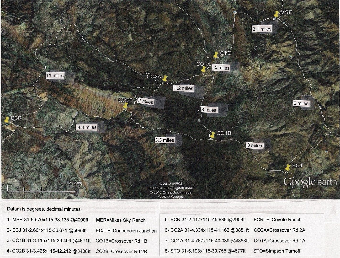
Here is a Google Earth shot of the roads around Mike's. The route you couldn't get thru two years ago was probably this years Baja 500 route. From MSR to CO2A to CO2B, this was the washed out area, to ECR. I got thru in my Tacoma by going down a 30 embankment and working my way thru the rock field. The route from CO2A north around to ECR has been open for sometime. It was closed due to a major washout just to the left of the pin at CO2A.


mtgoat666 - 5-17-2013 at 01:37 PM

Quote:
Originally posted by 56MM#
Lastly, has anyone else observed that some of the roads within PN that were open 10 or more years ago are now closed?


Not sure which specific roads you are asking about,... but up on the plateau in the park, many of the old roads are closed to public vehicles (only ranchers and park employees can drive them). The closed roads are great for mtn biking, horse riding or hiking. Much of the plateau has moderate topography, so easy for most to mtn bike the roads. The "open" unpaved roads are accessible in 2wd moderate clearance vehicles. I have noticed that some of the old now-closed roads have been entirely abandoned (not maintained or used by ranchers/park staff) and are returning to nature,... but still pretty good paths for non-motorized recreation.

805gregg - 5-17-2013 at 06:03 PM

Mike's Sky ranch is a pretty much a non destination any more, I would skip it

[Edited on 5-18-2013 by 805gregg]

Ken Cooke - 5-17-2013 at 10:08 PM

Quote:
Originally posted by 805gregg
Mike's Sky ranch is a pretty much a non destination any more, I would skip it

[Edited on 5-18-2013 by 805gregg]


On the Mike's Facebook page, there are over 4,800 'Friends' - almost to the limit of 5,000 total allowed. :!:

This photo makes it look like a pretty happening place.


[Edited on 5-19-2013 by BajaNomad]

TMW - 5-18-2013 at 05:06 PM

The high times for Mikes is when the SCORE races go thru there and for the last several years there were none. Even so a lot of off roaders still go there. Most of the off road tours stop there. It's more of a weekend shindig than weekdays. With the Baja 500 going thru this years a lot of racers, chasers and pit crew members will be there. If the room rates are too high, $70 per person includes breakfast and dinner last year when I was there, then you can always camp. Some think El Coyote is a better deal for the same price but better food. I can't say as I've never stayed at El Coyote. It would be hard to beat the bar at Mikes.