Originally posted by David K
It is an excellent road, and large trucks and maybe 4WD motorhomes have gone in, but there are a few sharp bends, short grades, and stream crossings
that could hang you up. It is only 20 miles, so if you have a motorbike or toad (Jeep, etc.), it would really be wise for you to check it out first.
Plenty of area along Hwy. 3 to park it, or in nearby San Matias village while you check it out.
I would like to hear other's opinions on going in there with a motorhome.
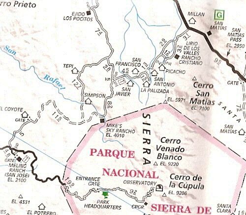
Here are my photos and road log (we went across the peninsula from San Quintin to San Felipe via Mike's Sky Rancho, in Sept. 2005: http://vivabaja.com/905/
The road to Mike's from Hwy. 3:

In Tacoma, we zipped along and with stops, averaged 20 mph:
Part 2, Mike's Sky Rancho north to Hwy. 3 (GPS at Map Datum NAD27 Mexico)
Mike's Sky Rancho: 0.0 miles, 0:00 hours elev. 3,992', 31°06.57', 115°38.10'.
Rancho El Conejo road: 5.1 mi., 0:21 hrs., 4,108', 31°09.94', 115°39.17'
La Cieneguita road northwest: 5.7 mi., 0:24 hrs., 4,115', 31°10.46', 115°39.30'
Rancho San Javier road: 8.3 mi., 0:30 hrs., 4,287', 31°11.70', 115°37.52'
Rancho San Antonio: 9.8 mi., 0:37 hrs., 3,956', 31°12.40', 115°36.72'
Road to west (Alberchigos): 13.3 mi., 0:48 hrs., 3,583', 31°15.16'. 115°36.00'
Rancho Picacho road south: 16.8 mi., 0:57 hrs., 3,438', 31°17.77', 115°35.06'
Highway 3 (just east of San Matias): 19.8 mi., 1:03 hrs., 3,143', 31°20.24', 115°34.39'
The AAA Map of Mike's road, 2010 edition:
 |


