BajaNomad

Crossing south near Yuma

woody with a view - 6-17-2013 at 07:49 PM

looks like i'm gonna make the surf tourney in BA in august. since it is more direct (and i've never gone this way) what would be the best most direct route thru San Flippy and on south? also, how long is the drive from yuma to H1 at chapala?

i'll prolly stop for breakfast tacos in san flippy or gonzaga and power thru to BA. maybe stop and pick up George and Sandra if they are going to be home.

BajaRat - 6-17-2013 at 07:53 PM

Woody, Glad to hear it...... Comin from SD or.......

and did Shari find out the dates?:cool:

[Edited on 6-18-2013 by BajaRat]

woody with a view - 6-17-2013 at 08:19 PM

from yuma. aug 4. i'll leave yuma friday before and come back the same way tuesday.

BajaRat - 6-17-2013 at 08:37 PM

two ways from Yuma,
Algadones is slow two lane farm roads in poor condition.
San Luis we think is the better route. Its well marked out of Yuma heading south to Somerton and on to San Luis crossing. Once across head west on Mex 2 toll road which is a nice 4 lane highway and on to Mex 5 south to San Filipe. An early start from Yuma will have you at Papa Fernadez for a fantastic lunch and on to GN well before sunset. If we leave Alfonsinas by 11 we make BA before sunset.:cool:

woody with a view - 6-17-2013 at 08:39 PM

cool. can't wait.

woody with a view - 6-18-2013 at 07:37 PM

so is that about 5 hours from the border to gonzaga? i want to leave around 3pm and get there by dark so i can see the sites. i'm not against driving in the dark with my offroad lights but i'd rather pull in during the evening.

Phil S - 6-18-2013 at 09:49 PM

Woody. You'll enjoy the San Felipe route. We did it about 18 months ago, and stayed at Francisco's (?) down from S.F. Was a great experience. Then on down to Coco's Corner, & over to Hwy 1. Watch out for the Vado's before S.F. Trust me. WATCH OUT FOR THE VADO's. You'll bottom out, and then 'sail into the air' if not driving slow. We plan on going that route again from Phoenix area this November. We crossed at Mexicali. Loved the drive, and from Coco's it's still under construction, but who's in a hurry when your in Baja???? Safe trip, Woody.

CortezBlue - 6-19-2013 at 02:04 AM

Quote:
Originally posted by BajaRat
two ways from Yuma,
Algadones is slow two lane farm roads in poor condition.
San Luis we think is the better route. Its well marked out of Yuma heading south to Somerton and on to San Luis crossing. Once across head west on Mex 2 toll road which is a nice 4 lane highway and on to Mex 5 south to San Filipe. An early start from Yuma will have you at Papa Fernadez for a fantastic lunch and on to GN well before sunset. If we leave Alfonsinas by 11 we make BA before sunset.:cool:


3 ways

If you are coming through Yuma from the east, Hwy 195/Araby Rd is the fastest. It is a new road that swings 21 miles south to San Luis. Less stop signs and 65 mph

woody with a view - 6-19-2013 at 04:25 AM

but how long to gonzaga? i'd like to watch the sunset with my toes in the sand and a ballena in my hand.

David K - 6-19-2013 at 07:22 AM

Quote:
Originally posted by woody with a view
but how long to gonzaga? i'd like to watch the sunset with my toes in the sand and a ballena in my hand.


Mexicali to San Felipe is 2.5 hrs. (125 miles) I Don't know the Algodones or San Luis to Hwy. 5 driving times, perhaps an hour?)

San Felipe to Gonzaga Bay is about 3 hrs. (100 miles), perhaps less if you don't stop to enjoy the view points of the islands. The first 50 miles to the Puertecitos junction is old style, slow highway (steep dips/ vados). The next 50 miles are fast, modern highway until the pavement ends, about 3 miles from the Alfonsina's Pemex/ Rancho Grande store.

woody with a view - 6-19-2013 at 04:32 PM

thanks!

Bwana_John - 6-19-2013 at 04:42 PM

We have taken all the ways in from AZ to go to Gonzaga and points south (Lukeville/Sonoyta, San Luis, Algonones, east and west Mexicali... and west Mexicali is the fastest (and also the easiest and safest) way in.

It just aint worth the "cultural experience" to make your way thru the back streets and roads.

David K - 6-19-2013 at 04:47 PM

I have only used west Mexicali southbound, but am surprised an Az person would like it over the closer east Mexicali crossing? Is getting south from Mexicali east that difficult?

Bwana_John - 6-20-2013 at 03:13 PM

Quote:

Is getting south from Mexicali east that difficult?

No its just some secondary crowded streets thru questionable neighborhoods, and not as fast.
We also had a problem on a weekend getting visas at Mexicalli east, we had to wait in line with everybody importing autos and a late opening bank with only one teller, it took 3.5 hours to get INTO Mexico that time(Christmas week).

We do leave through Mexicali East because that crossing is usually faster to go back into the US.

David K - 6-20-2013 at 05:31 PM

Quote:
Originally posted by Bwana_John
Quote:

Is getting south from Mexicali east that difficult?

No its just some secondary crowded streets thru questionable neighborhoods, and not as fast.
We also had a problem on a weekend getting visas at Mexicalli east, we had to wait in line with everybody importing autos and a late opening bank with only one teller, it took 3.5 hours to get INTO Mexico that time(Christmas week).

We do leave through Mexicali East because that crossing is usually faster to go back into the US.


Thank you for explaining that... I understand what you experienced... !

woody with a view - 6-20-2013 at 06:06 PM

i'll cross at san luis just because, and be able to find my way back fairly easy!

Bwana_John - 6-21-2013 at 06:18 PM

Quote:

i'll cross at san luis just because, and be able to find my way back fairly easy!

Use Cerro Prieto with all the geothermal steam power generating stations as a landmark when you are driving down to figure where you are and where you need to go.

Its much easier than trying to follow the signs.

woody with a view - 6-21-2013 at 06:25 PM

WTH does that mean? i hate to ask for a map.

anywaze, i'll finger it out! i'm never on vacation until i leave myself behind......

BajaRat - 6-21-2013 at 08:28 PM

Woody when you cross, Mex 2 is the first stop light, turn right west and that's it your on a nice 4 lane hwy. A couple of tolls ( one is the San Felipe off ramp ). That parts weird, you have to exit right and go a few blocks north before you can u turn south to San Felipe. have fun :cool:

Bwana_John - 6-22-2013 at 08:09 AM

Quote:

Mex 2 is the first stop light, turn right west and that's it your on a nice 4 lane hwy. A couple of tolls

If you are coming from Yuma, using Mex 2 from San Luis to get to San Felipe and points south is farther, slower, and costs more than taking US 8 to Mexicali to Mex 5

A shorter route from San Luis uses Son 40 and comes out on Mex 5 via BCN 4 (but again slower than US 8 to Mex 5 from Yuma)
Quote:

Use Cerro Prieto as a landmark

Quote:

WTH does that mean?

Big black prominent hill with steam vents, you will be north-east of it to start, and are going to south-west of it to get to Mex 5


[Edited on 6-22-2013 by Bwana_John]

woody with a view - 6-22-2013 at 08:18 AM

thanks!

David K - 6-22-2013 at 08:33 AM

Quote:
Originally posted by Bwana_John
Quote:

Mex 2 is the first stop light, turn right west and that's it your on a nice 4 lane hwy. A couple of tolls

If you are coming from Yuma, using Mex 2 from San Luis to get to San Felipe and points south is farther, slower, and costs more than taking US 8 to Mexicali to Mex 5

A shorter route from San Luis uses Son 40 and comes out on Mex 5 via BCN 4 (but again slower than US 8 to Mex 5 from Yuma)
Quote:

Use Cerro Prieto as a landmark

Quote:

WTH does that mean?

Big black prominent hill with steam vents, you will be north-east of it to start, and are going to south-west of it to get to Mex 5


[Edited on 6-22-2013 by Bwana_John]


woody with a view - 7-30-2013 at 08:04 PM

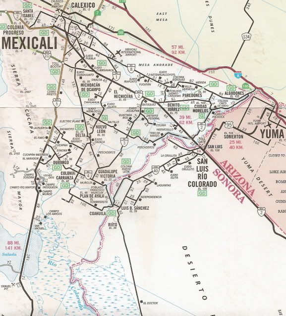
okay, so looking at the map above, which would be the route from algagones? is it signed fairly well? i'm not against an adventure but i'd like to be in Gonzaga before dark. heading out around 1pm Thurs.

mcfez - 7-30-2013 at 08:21 PM

I would take the east gate.............less stops and turns than algagones. Once you are on the main highway (5).....it's a straight shot and very easy road. I do around 70 til I hit San Felipe......only slowing down for three little towns that are a few blocks long...and the checkpoint.

Pass San Felipe airport....you can speed up again....but not as fast. The road is winding ...but 60ish is a good speed. Slow down at marker 28 til you past that town....the cops are active there. Up a few miles the new improved highway kicks in.....super road.....and the sights are fantastic.

Enjoy you trip..............

David K - 7-30-2013 at 08:54 PM

Km. 35 is the little town of Delicias.

MICK - 7-31-2013 at 06:32 AM

I drive this about once a month and I have taken every way possible. There is no good way thru Algodones unless you drive it all the time one wrong turn (easy to do) and you are driving thru a lot of small towns going real slow. From San Luis taking Mex 2 (toll) over to 5 south it takes about 1 hour. There is a military stop along that route with many trucks at it most times. You can just go around the trucks they are in a different lane but it is sometimes hard to tell.
Taking US8 to Mexicali east is about the same time but you can get caught in the Border check station on 8 (your tax dollars at work) I have sat there for 45 mins before.
Good luck
Mick

woody with a view - 7-31-2013 at 01:19 PM

i was given directions by my laborer:

cross at algodones and at B Street turn right. go 4 streets to fire station and turn left. follow sign to San Flippy. basically 2 south to 3 south to 4 west to 5 south. is it as simple as the map says?

redmesa - 7-31-2013 at 02:58 PM

This all sounds very informative but the surf competition (last heard) is friday and saturday August 2nd and 3rd.

DavidE - 7-31-2013 at 03:42 PM

Take care Vizcaino to the end of the construction zone. It's a real mess sometimes. Half hour delays waiting for a motor grader to blade out a windrow and then a roller to compress it.

woody with a view - 7-31-2013 at 05:02 PM

Quote:
Originally posted by redmesa
This all sounds very informative but the surf competition (last heard) is friday and saturday August 2nd and 3rd.


the kids are friday. i'll be there for lunch.

woody with a view - 7-31-2013 at 05:04 PM

Quote:
Originally posted by DavidE
Take care Vizcaino to the end of the construction zone. It's a real mess sometimes. Half hour delays waiting for a motor grader to blade out a windrow and then a roller to compress it.


4x4 means no waiting!

MICK - 8-1-2013 at 07:41 AM

It is not that simple. some of the signs are not there or you will miss them. Once again this will also take you thru several small towns where you will follow many slow trucks and it will take you about 1 1/2 hours to get to 5. and that is if you don't get lost.
Mick